


Below is the uncorrected machine-read text of this chapter, intended to provide our own search engines and external engines with highly rich, chapter-representative searchable text of each book. Because it is UNCORRECTED material, please consider the following text as a useful but insufficient proxy for the authoritative book pages.
2 Missouri River History, Management, and Legal Setting Much of western history is a series of lessons in consequences. Wallace Stegner, 1962 The Missouri River flows through several different landscapes and physical regions on its path from the Rocky Mountains to the Mississippi River. The mountainous terrain in the basinâs western reaches, the aridity in the basinâs western and middle sections, and the more humid climate in the eastern part of the basin help explain the basinâs ecology, human uses of the land, and its history. Humans have altered the Missouri River and surrounding lands to address both the challenges of limited water supplies during drought and high flows during floods. In some cases, these alter- ations have led to conflicts among the Missouri basinâs upstream and down- stream states. They have also resulted in significant modifications of the basinâs natural environment in general and of the Missouri River and flood- plain ecosystem in particular. PHYSICAL GEOGRAPHY During the last Ice Age, glaciers that extended southward from Canada into the northern United States defined the Missouri River basinâs north- eastern boundary. Glacial lobes directed the Missouri River drainage to- ward the Mississippi River. Before the glaciers, much of the upper basin (northward of the Bad Riverâs present confluence with the Missouri at Pierre, South Dakota) drained northeastward into Hudson Bay. On the basinâs southern margins, a low ridge and the Ouachita Mountains today separate the Missouri River basin from the Arkansas River basin. 21
22 THE MISSOURI RIVER ECOSYSTEM FIGURE 2.1 Missouri River basin landforms. SOURCE: Erwin Raisz, 1954. The basinâs northern landscapes include level to gently rolling plains and hills composed largely of glacial till. The region between the Missouri River (on the north) and the South Dakota-Nebraska border (on the south) is arid and has eroded to form deep valleys. From there to the basinâs southern boundary lie the Great Plains, with their characteristic widely- spaced streams and broad, flat valleys. In the basinâs eastern third, the plains give way to upland plateaus and gently rolling till plains. Annual rainfall varies from 8 inches in the foothills of the Rockies to over 40 inches in parts of Missouri and Iowa. Much of the basin is characterized by the cold winters and hot summers associated with a continental climate (drier in the basinâs western portions, more humid in the east). Throughout the basin, most rain falls during the spring and summer. The basinâs western rivers, such as the Marias and the Yellowstone, gain a large portion of their flow from spring snowmelt. In eastern portions of the Missouri basin, the climate is humid conti- nental and the vegetation is medium-height bluestem grasses, with mixed oak and hickory forest. Moving westward into more arid regions, grasses generally become shorter and more sparse. In this portion of the basin that
MISSOURI RIVER HISTORY, MANAGEMENT, AND LEGAL SETTING 23 straddles the one-hundredth meridian, irrigation is practiced in some areas (some with water tapped from the Ogallala Aquifer), but some crops can be grown without supplemental water during wetter years. Moving west- ward, low grasslands stretch from near the one-hundredth meridian to the Rocky Mountain foothills, dominating the landscape in the basinâs western sections. In this arid section, agriculture consists primarily of ranching, dryland wheat farming, and irrigated agriculture. Along its course from Three Forks, Montana to its confluence with the Mississippi River in St. Charles County, Missouri, just north of St. Louis, the Missouri River flows through or borders seven states, with the river basin encompassing ten states. The westernmost tributaries of the Missouri River begin at elevations near 11,000 feet above sea level. Flowing down- stream and eastward through Montana, the Missouri River is joined on the north by the Milk River, the Missouriâs only major tributary that originates in Canada. Farther downstream, the Yellowstone River joins the Missouri near the MontanaâNorth Dakota border. It is then joined by the Little Missouri, Knife, Cheyenne, Bad, Grand, Niobrara, Platte, and Kansas riv- ers and several smaller tributaries, all of which enter from the Missouriâs right bank. Between the Milk River in Montana and the James River (which enters the Missouri just northwest of Sioux City, Iowa, on the southern South Dakota boundary), no major tributaries join the Missouri from the north (its left bank). Downstream from the Missouri RiverâJames River confluence, the Vermillion, Big Sioux, Little Sioux, Chariton, Osage, and Gasconade rivers enter the Missouri from both the left and right banks. Where the Missouri joins the Mississippi just above St. Louis, the Missouri River has fallen to an elevation of slightly less than 400 feet above sea level. HUMAN SETTLEMENT Native Americans were the Missouri River basinâs first known inhabit- ants. Spanish explorers, followed by British and French fur traders, were the first Europeans to enter the Missouri basin. The exploration and settle- ment of the Missouri basin represents a fascinating and well-documented chapter in the history of United Statesâ westward expansion (DeVoto, 1947; Webb, 1931). The basin became part of the United States with the Louisiana Purchase in 1803. President Thomas Jeffersonâs interests in the basinâs physical geography, ecology, and its Native American tribes led to Lewis and Clarkâs celebrated expedition. Between 1804 and 1806, Lewis and Clarkâs âCorps of Discoveryâ explored the river from its mouth to its headwaters and opened the Missouri basin to the exploration and settlement of a growing United States (Ambrose, 1996). In âthe greatest wilderness trip ever re- cordedâ (Botkin, 1995), the groupâs journey was remarkable not only for
24 THE MISSOURI RIVER ECOSYSTEM the distance covered and the dangers and hardships encountered and over- come, but also for its scientific discoveries. Lewis and Clarkâs reports led subsequent explorers to see the region as a route to the West for trade with the Indians, and a region for possible mineral extraction. In the early nineteenth century, travelers within the basin relied on the river for transportation and on the benevolence of the natives for their survival. Navigation eventually reached Fort Benton, Montana, in the Rocky Mountain foothills, and carried a great deal of river traffic in the first half of the nineteenth century. But as the railroads expanded and reached the banks of the Missouri (St. Joseph, Missouri, 1859; Bismarck, North Dakota, 1872) and eventually crossed over it to move to the West (reaching Casper, Wyoming, in 1884), reliance on water- ways began to decline. Railroads ultimately had a greater influence on the basinâs settlement patterns, especially in its upper reaches, than did steam- boats and river navigation. The westward movement brought settlement and farming, as well as commercial hunting. The basinâs settlement initially resulted in only lim- ited ecological impacts. But as these activities intensified, they began to change the lives of Native Americans and the ecology of the Great Plains. The Missouri basinâs settlement was encouraged by public land policies such as the Homestead Act of 1862 and Desert Lands Act of 1877. How- ever, settlement in the basinâs upper, interior reaches was more ephemeral compared to other parts of the west, as droughts and harsh winters there caused many to leave the basin. During the nineteenth century, the prevailing assumption was that land disposition policies would be sufficient to settle and sustain the West, in- cluding much of the Missouri River basin. But by the twentieth century, based in part on John Wesley Powellâs surveys of the arid regions of the western United States (Powell, 1878), the federal government realized that more substantial government intervention would be necessary to encourage and sustain further settlement and economic development in the vast, harsh portions of the basin. CHANGES IN THE MISSOURI RIVER AND FLOODPLAIN Irrigated Agriculture Throughout the latter half of the nineteenth century, settlement of the western United States placed increasingly larger demands on the regionâs limited water resources. This period saw an increase in private sector efforts to move water from rivers to nearby arable lands. For example, by 1850 the Mormons were irrigating over 16,000 acres in the area that would become the state of Utah (Worster, 1985). Within the Missouri basin,
MISSOURI RIVER HISTORY, MANAGEMENT, AND LEGAL SETTING 25 irrigation cooperatives appeared in Colorado as early as 1859 (Dunbar, 1983). Small diversion dams were constructed and ditches were dug to carry diverted waters to fields for irrigation. Larger dams were eventually used to create storage reservoirs to capture spring runoff for use in the hot and dry western summers. By the end of the nineteenth century, many basin farmers were collaborating to develop irrigation projects that they hoped would ensure the availability of water for increasing acreage in agriculture. Settlement of the Missouri River basinâs arid areas required states to adjust their water laws to unfamiliar climatic conditions. The doctrine of prior appropriation, which provides that the water rights of users who first put water to beneficial use are senior to water rights established later, or âfirst in time, first in right,â was adopted in varying degrees in the Missouri River basinâs arid regions. Scholars continue to debate whether prior ap- propriation originated in New England to allocate the rights to the flow of streams among mill owners, or whether it was an application of mining and irrigation customs developed in the west (Pisani, 1996). Whatever its ori- gins, it seems clear that prior appropriation represented a conscious effort to develop an irrigation society in an area of variable rainfall. The two most arid Upper Basin states, Montana and Wyoming, re- jected the common law of riparian rights in favor of prior appropriation. States split by the one-hundredth meridian took a more circuitous route to prior appropriation. The Dakotas initially adopted the common law of riparian rights and subsequently followed dual appropriative-riparian sys- tems until the 1950s and 1960s when riparian rights were extinguished. Kansas and Nebraska went through a similar transition (Wells Hutchins, 2 Water Rights in the Nineteen Western States 1-14, 1974). The more humid states of Iowa, Minnesota and Missouri followed the common law of ripar- ian rights and later supplemented them with permit systems. Areas along the Missouri River have never benefited from irrigated agriculture to the extent that other areas in the west have. Irrigated agricul- ture was in its infancy in the western United States during the 1850s and 1860s, a period during which farmers had limited political influence. But drought in the late 1880s, combined with the efforts of irrigation advocates such as George Maxwell and William Smythe, created the political momen- tum for a federal reclamation policy to settle the west (Pisani, 1992). The Reclamation Act of 1902 established federal support of irrigation in the western United States as a national policy and created the Reclama- tion Service, later renamed the Bureau of Reclamation. Missouri River basin residents were quick to recognize the potential for securing resources water resources development; they were, however, less able to profit from the program than areas farther west that had established irrigation districts. As western historian Walter Prescott Webb observed, âThe United States
26 THE MISSOURI RIVER ECOSYSTEM government, after the most extensive surveys has not selected a project on the High Plains. . . . by law the national government was compelled to put at least one project in each arid state except Texas, but it will be noticed that the projects in Colorado, Nebraska, and North and South Dakota are placed in the most western portions of those statesâ (Webb, 1931). By 1904, irrigation projects were under way in the Missouri River basin at several locations. For example, by 1909, the Yellowstone River was being diverted in two locations. By the 1930s, most of the Missouriâs tributaries had one or more dams, diversion structures, or pump stations to store water or to shift it from the rivers and streams to arable lands. By 1939, federal dams had been constructed on the Belle Fourche, Milk, North Platte, Platte, Sun, and Shoshone rivers and their tributaries. Construction also was under way on a 14-dam project that would move 260,000 acre-feet of water a year from the Colorado River basin to the Big Thompson River of the Missouri River basin (Tyler, 1992). One pumped irrigation project was built along the Missouri River near its junction with the Yellowstone River. In these projects, irrigated crops such as sugar beets, beans, flax, and grains replaced dryland agricultural crops. Navigation As early as 1824, Congress appropriated funds to the U.S. Army Corps of Engineers to remove large tree snags and other obstacles in the Missouri River channel. Government snag boats and river-based work crews contin- ued their efforts to improve navigability through the late 1870s. However, the volume of upper Missouri River traffic began to decline in mid-century, and by the late 1880s, river traffic essentially ended north of Sioux City, Iowa. At about the same time, the Corps began stabilizing riverbanks in populated areas to reduce losses to riverfront property. In 1910, Congress, under pressure from farming and barge interests, authorized the development of a six-foot-deep navigation channel on the Missouri River from Kansas City to St. Louis. The project stalled, however, when Congress, faced with World War I, did not appropriate adequate funds for the project. By 1915, all activities had essentially stopped. In 1927, the project was resumed when Congress authorized extension of the six-foot-deep channel to Sioux City, Iowa, and authorized a feasibility study of a nine-foot-deep channel from Kansas City to St. Louis. With funding secured, the Corps launched a program combining bank stabiliza- tion with dike construction and strategic dredging designed to narrow the river and eliminate meandering. The dike fields soon filled with sediment, restricting the river to a relatively narrow channel. Wide bends were elimi- nated, the channel was narrowed, and the riverâs velocity increased. The result was a self-scouring channel that reduced the amount of dredging
MISSOURI RIVER HISTORY, MANAGEMENT, AND LEGAL SETTING 27 required. The Corpsâ focus on the lower basin ultimately linked naviga- tion-enhancement activities and dams for the first time. In 1945, Congress extended the authorization for a nine-foot-deep navigation channel on the Missouri River from Kansas City, Missouri, to Sioux City, Iowa. Flood Damage Reduction Despite the hazards associated with the Missouri Riverâs floodplains, the benefits of settling on them attracted settlers and resulted in increased occupancy and development. In the late eighteenth and early nineteenth centuries, there was no coordinated federal program for flood damage reduction structures and policies, and large floods resulted in significant losses of life and property. Congress considered flood control primarily a local responsibility until passage of the 1917 Flood Control Act, which placed flood control on equal footing with navigation within the Corps and authorized Corps flood-control programs on the Mississippi and Sacra- mento rivers. In 1927, Congress passed a River and Harbor Act that authorized the Corps to conduct surveys to formulate comprehensive water development plans in several river basins (because the provisions of the surveys were described in House Document No. 308, the surveys were known as the â308 Reportsâ). In examining the Missouri River basinâs flood-control and navi- gation needs, the Corps identified several major projects intended to assist in flood damage reduction and the development of the basin. There was also catastrophic flooding on the Mississippi River in 1927, which cata- lyzed further federal involvement in flood-control activities (Barry, 1998). The Flood Control Act of 1936 declared floods a federal responsibility and established a national flood-control policy. Following a major Missouri River flood in 1943, the Corps prepared a report to Congress proposing five major dams on the mainstem Missouri River, two on the Yellowstone River, and five on the Republican River. These flood damage reduction works would be supplemented by levees on the banks of the Missouri River from Sioux City, Iowa, to St. Louis and would complement another ten dams already authorized for construction on Missouri River tributaries (Ferrell, 1993). Hydropower Construction of hydropower dams began in the Missouri basin during the second half of the nineteenth century. In 1890, the Corps of Engineers was given responsibility for approving all nonfederal dams on navigable waters. The 1920 Federal Power Act shifted primary responsibility for the approval of such nonfederal dams to the Federal Power Commission after
28 THE MISSOURI RIVER ECOSYSTEM Congress rejected federal coordinated development in favor of regulated private development (Holmes, 1972). Hydropower was considered a project purpose for most Bureau of Reclamation dams, and the revenue from hydropower sales was often used to help offset funding shortfalls in irrigation repayments. The Corps was also authorized to include hydro- power as a project purpose, but only as a subsidiary to flood control or navigation. Taking advantage of the hydropower potential in the upper Missouri basin, private utilities had constructed several hydropower dams on the tributaries upstream from Fort Peck. THE PICKâSLOAN PLAN Setting and Impetus The most important and lasting alteration of the Missouri River ecosys- tem resulted from the PickâSloan Plan. PickâSloan was the product both of the Great Depression and the progressive conservation movementâs belief that multiple-purpose water projects would stimulate growth in the arid West (Hays, 1999). The gospel of the progressive movement was that growth would follow the âharnessingâ of rivers. The PickâSloan Plan also reflected the arid lands reclamation movement, which was promoted at the turn of the century by irrigation enthusiasts like George Maxwell and William Smythe. Unsustainable agricultural practices on the Great Plains, an economic depression, and the prolonged drought in the 1930s that created the Dust Bowl focused the Bureau of Reclamationâs attention on additional storage and diversions in the Missouri basin. Bureau of Reclamation engineers subsequently developed plans for three large dams on the mainstem of the Missouri River downstream from Fort Peck, Montana, as well as for dams on the Yellowstone, Niobrara, Platte, Kansas, and Upper Missouri rivers and on several of the Missouriâs western tributaries. These proposed projects would irrigate more than 4 million acres in the basin, and an additional 1.4 million acres in the SourisâRed River basin (which lies north- east of the Missouri River basin) through inter-basin water transfers from the Missouri River basin. Proponents of these schemes believed that the projects would not only increase the extent of basin agriculture, but that they would also provide construction jobs for thousands of basin residents (Ferrell, 1993). As the drought of the 1930s began, it was apparent that even with the future construction of those dams, there would be insufficient water in the Missouri River to maintain a six-foot deep navigation channel. A 1932 Corps report proposed that it build a major dam on the Missouri River at Fort Peck, Montana. The dam was intended to store water that could be
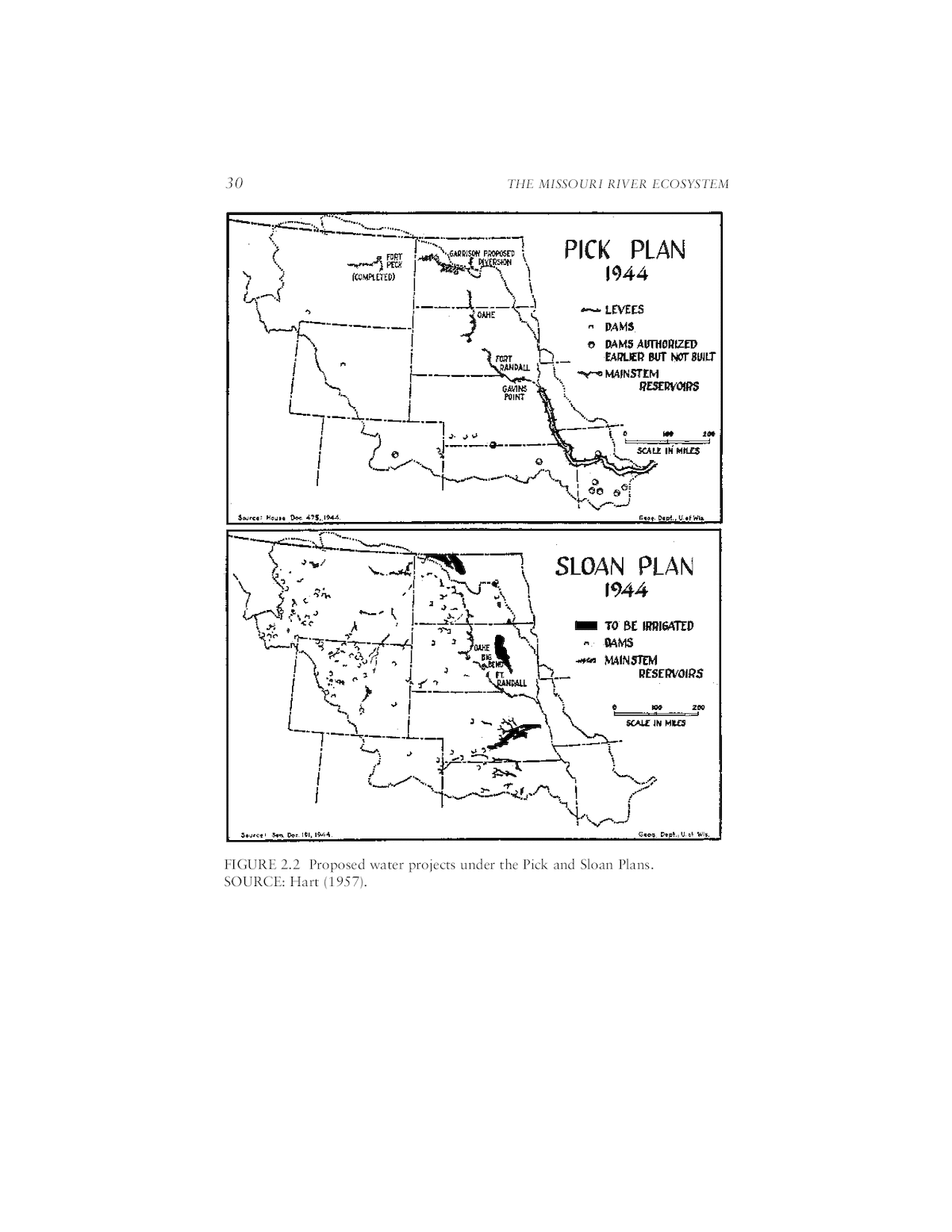
MISSOURI RIVER HISTORY, MANAGEMENT, AND LEGAL SETTING 29 released to supplement flows in the Missouri River downstream from Sioux City, Iowa (Ferrell, 1996). In 1933, Congress passed the National Industrial Recovery Act (NIRA), which authorized the President to undertake public works projects. The Fort Peck project appeared to offer an opportunity to put people in the Upper Missouri basin to work and to support Missouri River navigation. Less than four months after the NIRA was enacted, President Franklin D. Roosevelt directed construction to begin on Fort Peck Dam. By 1939, the dam, then the largest in the basin, was completed and was beginning to store a planned 19.5 million acre-feet of Missouri River water. The dam was approved to provide flow for the authorized Missouri River navigation project and, when feasible, for the development of hydropower under the auspices of the Bureau of Reclamation. Merging the Plans of the Bureau and the Corps The PickâSloan Plan was an amalgam of separate Missouri River devel- opment plans prepared by the Bureau of Reclamation and the U.S. Army Corps of Engineers. The Corps of Engineers was proceeding with plans for flood-control and navigation-enhancement dams and reservoirs under the aegis of its Missouri River Division Engineer, Colonel Lewis Pick. The Corpsâ plans responded to the devastating 1943 Missouri River floods and to lower basin navigation interests. The Bureauâs water development plan- ning for the Missouri River basin was the responsibility of its regional director William Glenn Sloan. The Bureauâs chief goals were irrigation development and hydroelectric power generation. It proposed some ninety dams and reservoirs across the basin, along with several hundred irrigation projects covering 4.7 million acres, which would have doubled the basinâs irrigated acreage (Carrels, 1999). Both plans included several large mainstem reservoirs (Figure 2.2 shows the Pick Plan and the Sloan Plan). Both were presented to Congress at the same time that Congress was considering legislation to create a Missouri River Authority that would promote and coordinate comprehensive devel- opment. There was thus considerable pressure from President Roosevelt, basin water interests, and influential members of Congress to create a single basin development plan. (Support for PickâSloan was not unanimous, how- ever. Native Americans were particularly opposed to it. See Box 2-1.) The similarities between the Pick Plan and the Sloan Plan enabled the two agencies to meet in Omaha, Nebraska in October, 1944 to quickly recon- cile the differences between the two plans and combine them into a unified plan. Congress settled the jurisdiction of the two agencies: the Corps would build and operate the mainstem dams and the Bureau would allocate the water dedicated to irrigation. With this and other minor adjustments,
30 THE MISSOURI RIVER ECOSYSTEM FIGURE 2.2 Proposed water projects under the Pick and Sloan Plans. SOURCE: Hart (1957).
MISSOURI RIVER HISTORY, MANAGEMENT, AND LEGAL SETTING 31 Box 2.1 Native Americans and PickâSloan The PickâSloan Plan was widely supported by water interests throughout the Missouri River basin. Native American tribes, however, took a dim view of the project. The Missouri River floodplains were essential to the tribes. Although the Fort Laramie Treaty of 1851 had granted tribes a permanent homeland for their agricultural economy and culture along the Missouri River, little consideration was given to the tribes in the enactment of the 1944 legislation. The PickâSloan reservoirs displaced thousands of Native Americans from their lands. The five Corps of Engineers mainstem dams displaced roughly 900 Native American families (Lawson, 1982). Tribal groups affected were the Arikaras, Chippewas, Mandans, and Hidatas of North Dakota; the Shoshones and Arapahos of Wyoming; and the Crows, Crees, Blackfeet, and Assiniboines of Montana (Law- son, 1994). In total, the Missouri River mainstem dams flooded over one million acres, much of it belonging to Native Americans (Shanks, 1974). According to Lawson (1994), âThe PickâSloan Plan . . . caused more damage to Indian land than any other public works project in America.â All the mainstem dams in North and South Dakota, except Gavins Point Dam, flooded the Native Americansâ most productive land and resulted in large numbers of ousted people. Garrison Dam submerged 155,000 acres on the Fort Berthold Indian Reservation. The reservation ended up with five isolated areas of remnant upland plains. A total of 1,700 people were relocated, which represented 289 of the tribeâs 357 families. The tribe lost its winter grazing in the river bottom and 90 percent of its timber. Most of its lignite coal seams that provided heating fuel became inaccessible. Wild game, an important food source, was greatly dimin- ished. Oahe Reservoir submerged the river bottoms of the Standing Rock and Cheyenne River reservations. 160,000 acres were covered and 351 families were relocated. Up to 90 percent of the timberland and 75 percent of the corn land were submerged. As at Garrison Dam, the tribes lost their winter grazing and their wild game food sources. Big Bend and Fort Randall dams dislocated families from the Yankton, Rosebud, Crow Creek, and Lower Brule Reservations. The dams flood- ed over 20,000 acres of tribal land, with 17,000 of those being inundated on the Crow Creek and Lower Brule reservations, where 120 families were relocated. The issue of compensation for the loss of their valued floodplains has not been resolved to the tribesâ satisfaction: âThe tribes are still waiting for fair compensation for the lands taken, as well as water and electricity for homes on the reservationâ (Thorson, 1994). Between 1947 to 1949, the tribes received $12.6 million for their lost lands (about $81 per acre) and various relocation costs. This level of compen- sation was viewed as inadequate and was partially rectified over forty later when, in 1991, Congress adopted the recommendations of the Garrison Diversion Unit Joint Tribal Advisory Committee and established a $149 million recovery fund (Thorson, 1994). Native Americans continue to be involved in the details of PickâSloan and Mis- souri River mainstem dam operations. For example, in October 2000 the Standing Rock Sioux Tribe sued the Corps. The suit related to concerns about the impacts of the fluctuating levels of Lake Oahe on burial sites along the shoreline. The Corps and the tribe subsequently agreed on a settlement that will provide the tribe with an opportunity to help the Corps monitor and stabilize the sites and prevent further erosion (Jehl, 2000).
32 THE MISSOURI RIVER ECOSYSTEM Congress ratified the Omaha agreement in the Flood Control Act of 1944, but as a Corps historian noted, â[t]he accord did not purport to deal with the policy issues that arose as project development proceeded. . . . The conferees had not considered interdependence of hydropower, irrigation, navigation, and municipal and industrial water supply; nor [sic] the effects on water and related land and fish and wildlifeâ (Ferrell, 1993). The Flood Control Act of 1944 also granted the Corps responsibility for flood-control structures in the lower Missouri River and its tributaries in Kansas and Missouri. The Bureau of Reclamation was to construct and operate dams on the Missouri upstream from Fort Peck Dam and on upper basin tributaries. The Corps was to determine flood-control and naviga- tion storage capacities in all dams in the basin, and the Bureau would determine irrigation potential. Subsequently, the Fort Peck project would be operated primarily for irrigation (Ferrell, 1993). The last of Pickâ Sloanâs five mainstem dams (Table 2.1 and Figure 2.3) was completed in 1963 (Fort Peck Dam was completed before PickâSloan). In addition to the PickâSloan dams, the U.S. Natural Resources Conservation Service (for- merly the Soil Conservation Service) has constructed hundreds of smaller water projects on the Missouri Riverâs tributaries. State and Federal Governance Under PickâSloan When the PickâSloan Plan was signed, it was assumed that its authori- zation would be followed by a new basinwide governance organization. A Missouri Valley Authority was proposed in 1936 and again in 1944, but these proposals were strongly opposed and were never enacted (Ferrell, 1996; Ridgeway, 1955). A Missouri Basin Inter-Agency Committee (MBIAC) was formed in 1945. The MBIACâs membership included repre- sentatives from several federal agencies (Trelease (1953) listed forty-three federal agencies with some role in Missouri basin development) and five governors chosen by a Missouri River States Committee (Thorson, 1994). The MBIAC was hampered by the lack of a clear legal mandate and it was terminated in the early 1970s (ibid.). Pursuant to Title II of the 1965 Water Resources Planning Act, the Missouri River Basin Commission (MRBC) was established in 1972 and assumed the responsibilities of the former Missouri Basin Inter-Agency Committee. Membership of the MRBC remained a mix of federal and state representatives, but it was organized with a staff and conducted planning studies at the sub-basin level, often focused on basins within a single state. The 1965 federal legislation sought comprehensive water resources plan- ning that went beyond agency-specific efforts and that included substantial roles for basin states. Other basins in which commissions were established were in New England, the Ohio River basin, the Pacific Northwest, the
MISSOURI RIVER HISTORY, MANAGEMENT, AND LEGAL SETTING 33 TABLE 2.1 Corps of Engineers Missouri River Dams Dam Year of Dam Closure Fort Peck 1937 Fort Randall 1952 Garrison 1953 Gavins Point 1955 Oahe 1958 Big Bend 1963 FIGURE 2.3 Missouri River mainstem dam elevations and profile. SOURCE: USACE, 1979. Great Lakes, and the Souris-Red-Rainy area (Rieke and Kinney, 1997). However, the commissions were organized at the end of the dam building era and never developed clear missions. MRBC members represented thirteen federal agencies, all ten basin states, the Yellowstone Compact Commission, and the Big Blue River Com- pact Administration (Thorson, 1994). The commission developed a man- agement plan, published numerous reports, and established a hydrology model that supported water use monitoring and accounting within the basin. But the âcommissionâs greatest accomplishment was providing a forum for communication and information sharingâ(ibid.). This accom- plishment did not lead to a basin-wide management regime, however, be- cause the MRBC and the other Title II commissions were generally seen as
34 THE MISSOURI RIVER ECOSYSTEM ineffective, as they had lost their primary missionâthe review and coordi- nation of large projects for consistency with other basin resources manage- ment objectives. They were thus all terminated in 1981. Termination of the MRBC eliminated one of the important forums for frequent discussions and cooperative activities on Missouri River water management issues. The Missouri Basin states immediately formed the Missouri Basin States Association (MBSA). As the staff addressed several ongoing studies, issues concerning the rights of states to market water outside the basin arose among the states, and the utility of the MBSA came into question. In 1986, the states attempted to develop a compact agreement, which failed because the states were unable to address all the concerns of the states, and they were unable to develop a common approach to address federal and tribal claims to water (Thorson, 1994). In 1988 the MBSA was dissolved when the basin states either concluded that it was not effective in resolving basin conflicts or was peripheral to their interests (ibid.). In 1990 the MBSA was reconstituted to fill the representation vacuum created by the dissolution, and its membership was expanded to include tribal representation. The MBSA also sought to increase its general base of support throughout the region and was renamed the Missouri River Basin Association (MRBA). Eight basin states are currently members of the association (Colorado and Minnesota currently do not participate). Members are appointed by their governors and normally are senior water management officials. In 1990, the Mni Sose Tribal Water Rights Coalition, which was formed in 1988 to assist 28 of the 29 basin tribes in securing their water interests, became a voting member of MRBA. In 1998, the MRBA attempted to mediate an agreement among the states concerning the development of new operating rules for the Missouri mainstem, but it was unable to achieve consensus. Another organization that promotes dialogue on Missouri River man- agement issues is the Missouri River Natural Resources Committee (MRNRC). Formed in 1987 to help promote ecological stewardship, mem- bership of the MRNRC includes the state fish and wildlife agencies of the seven states that the Missouri River flows through or borders. The Corps, the U.S. Fish and Wildlife Service, and the U.S. Department of Energyâs Western Area Power Administration (WAPA) are ex officio, non-voting members, and the U.S. Geological Survey, the Bureau of Reclamation, and the National Park Service are cooperating members. Federal agencies with Missouri River management and science respon- sibilities currently meet once or twice a year on Missouri River issues under the auspices of a Missouri River Roundtable (Box 2.2 lists federal agencies with water science and management roles in the basin). Roundtable meet- ings focus on identifying prospective collaborative efforts, and they provide members the opportunity to share information on relevant activities.
MISSOURI RIVER HISTORY, MANAGEMENT, AND LEGAL SETTING 35 Roundtable members have mutually agreed to avoid areas of conflict and focus on areas of cooperation. The net result of the inability of the states and federal government to develop an effective basinwide governance structure is that the Missouri River is currently managed almost exclusively by the Corps of Engineers according to the Flood Control Act of 1944 (which includes the PickâSloan Plan). Pick-Sloan had two major consequences for Missouri River manage- ment decisions. First, it dedicated upstream storage to three primary uses: hydropower generation, navigation enhancement, and flood control. Sec- ond, it made the Corps the de facto mainstem river master and reduced the influence of other federal agencies in mainstem management issues. The actâs key provisions included: a. declared the Congressional policy to recognize rights and interests of states in water resources development and the requirement for consulta- tion and coordination with affected states. b. required the Corps to coordinate with the U.S. Department of the Interior in cases of waters rising west of the ninety-seventh meridian. c. authorized provision of recreation areas for public use, including recre- ation and fish and wildlife conservation. d. assigned the Secretary of the Army responsibility for prescribing use of storage allocated for flood control or navigation in all reservoirs con- structed wholly or in part with federal funds, and e. authorized the Corps to include irrigation as a project purpose in the 17 western states. The Act also includes the following language inserted by Senators Jo- seph OâMahoney (Wyoming) and Eugene Millikin (Colorado) that guaran- tees the upper basin states a priority to use water for irrigation: The use for navigation, in connection with the operation and maintenance of such works herein authorized for construction, of waters arising in States lying wholly or partly west of the ninety-eighth meridian shall be only such use as does not conflict with any beneficial consumptive use, present or future, in States lying wholly or partly west of the ninety-eighth meridian, of such waters for domestic, municipal, stock water, irrigation, mining, or industrial purposes. (33 U.SC. 701-1.) Since approval of the Flood Control Act of 1944, the Corps has operated the mainstem system in accordance with its understanding of competing needs in the basin, its responsibilities described in navigation and flood- control legislation, and in response to congressional committee instruc- tions. Although the Bureau of Reclamation initially sought to establish a centralized basin-control system, it eventually acceded to Corps control
36 THE MISSOURI RIVER ECOSYSTEM Box 2.2 U.S. Water Resources Management and Science Organizations in the Missouri River Basin Army Corps of EngineersâResponsible for flood-damage reduction activities and navigation-enhancement activities; also involved in ecosystem restoration activities. The Corps constructed and operates thousands of dams across the nation, and it constructed and operates six mainstem dams on the Missouri River. Bureau of ReclamationâResponsible for water resources development and management activities in the 17 western (contiguous) U.S. states (i.e., those that straddle the one-hundredth meridian and westward). The Bureau constructed and operates the Canyon Ferry Dam on the Missouri River, along with many other dams across the western United States. Environmental Protection AgencyâWater-related responsibilities include estab- lishing drinking water quality standards, wastewater management, and wetlands, oceans, and watersheds. EPA jointly administers (with the Corps of Engineers) the Clean Water Actâs Section 404 program. EPA also monitors progress of na- tional programs for total maximum daily load pollutants and for reducing nonpoint source pollution. Federal Emergency Management AgencyâAdministers the National Flood In- surance Program, which provides flood insurance to communities that agree to assure that future floodplain structures meet safe standards. FEMA also conducts other flood hazard mitigation, response, and recovery activities. Federal Energy Regulatory CommissionâResponsible for reviewing, relicens- ing, and decommissioning federally licensed hydroelectric power dams. Fish and Wildlife ServiceâMajor responsibilities involve migratory birds, endan- gered species, certain marine mammals, and freshwater and anadromous fish. A because its proposed reclamation agenda had not been realized. Only the responsibility for tributary operations was left to the agency responsible for specific project construction. As the mainstem dams were completed and their reservoirs filled, the Corps assigned operation of the system to its Reservoir Control Center in Omaha, Nebraska, where it remains today. In 1953, to provide opportunities for coordination with the states and the other federal agencies, the Corps established a Coordinating Committee on Missouri River Mainstem Operations. This committee functioned for nearly three decades. In 1982, because the newly passed Federal Advisory Committee Act (FACA) created administrative requirements for the committeeâs operation and limited its ability to operate in executive session, and therein to forge consensus positions, the committee agreed to dissolve. The Corps announced that in place of the committee it would conduct semiannual public meetings to provide information about important water development issues. The Corps has also solicited comments on proposals for changes to dam and reservoir operations.
MISSOURI RIVER HISTORY, MANAGEMENT, AND LEGAL SETTING 37 major function is the identification and recovery of endangered species. Under the Endangered Species Act, the Service identifies species that appear to be endan- gered or threatened. The Service consults with other federal agencies and ren- ders âbiological opinionsâ on the effects of proposed federal projects on endan- gered species. Forest ServiceâManages federal âWild and Scenic riversâ and manages national forest lands to promote watershed protection. Geological SurveyâConducts scientific programs in several areas of water re- sources, including streamflow gauging, groundwater monitoring, water quality as- sessment (the USGS oversees the National Water Quality Assessment Program, or NAWQA), and ecosystem monitoring through its Biological Resources Division. National Park ServiceâHas regulatory and planning responsibilities on National Park lands. The Missouri basin contains dozens of national parks and national monuments. Natural Resources Conservation Service (formerly the Soil Conservation Service)âPromotes land-use management practices aimed toward reducing ero- sion and promoting conservation. NRCS seeks to reduce the risks of floods and droughts in the nationâs watersheds. Tribal GovernmentsâNative American tribes have federal public trust rights and responsibilities on their reservations. The Mni Sose organization represents 28 of the Missouri Basinâs Native American tribes in basinwide water policy discussions and formulation. Western Area Power AuthorityâMarkets and delivers hydroelectric power and related services within a 15-state region of the central and western United States, including most of the Missouri River basin. WAPA, one of four power marketing administrations within the U.S. Department of Energy, markets electricity from Bureau of Reclamation and Corps of Engineers hydropower dams. Since PickâSloan, the Corps has emerged as the Missouri River water master, although the river must be managed in the context of a larger suite of federal, state, and tribal laws. The Corpsâ role as the key federal agency in Missouri River management has been facilitated because there are rela- tively few private or public entitlements on the mainstem which conflict with its policies. No private individual or state âownsâ the flow of the Missouri. Each basin state can claim an equitable share by Supreme Court degree, interstate compact, or Congressional action, but the Missouri has never been apportioned by any of these methods. The federal ânavigation servitudeâ posits that no individual may assert a property right to the flow of a navigable river below the high water mark, but private entities and tribes may obtain a right to use a portion of the flow (individual water rights are described in Box 2.3). Because firm private and tribal rights exist primarily on the tributaries (with the exception of Montana), the Missouri is most accurately characterized as a regulated river, rather than a fully allocated one.
38 THE MISSOURI RIVER ECOSYSTEM Box 2.3 Water Rights in the Missouri River Basin State Use Entitlements. Each riparian state is entitled to an equitable share of the river, but the right must be based on prior or reasonably anticipated use. The rights can be firmed up by Supreme Court decree, interstate compact, or congres- sional apportionment. The states have explored these options, but they have not been implemented. In the 1980s, the Supreme Court rejected an original action that asserted that the PickâSloan Plan was a congressional apportionment. Article III, Section 2 of the U.S. Constitution provides that suits by one state against an- other state must be filed directly in the Supreme Court rather than in a lower feder- al court. In practice, the Supreme Court appoints a special master to take evi- dence and prepare a recommended decision, and the Court hears arguments by those who object to the special masterâs report. Individual Use Rights. Colorado, Montana, North Dakota, South Dakota, and Wyoming follow prior appropriation and allow an individual to perfect a right based on diversion and application to beneficial use. Iowa and Missouri recognize com- mon law riparian rights and permit rights. Riparian rights exist by virtue of owner- ship of land adjacent to a stream and do not depend on actual use. Kansas is now a pure appropriation state. Nebraska is a dual state and recognizes both riparian and appropriation rights. Rights of Indian Tribes. Indian tribes may claim group rights that have both ripar- ian and appropriative characteristics. Based on the Winters Doctrine of 1908, federal reserved water rights arise by virtue of the creation of a reservation. These rights date from the date of the creation of the reservation (or perhaps time imme- morial if they are true aboriginal rights) and do not depend on the application of water to beneficial use. However, the rights have been primarily recognized for irrigation and have not been of great benefit to the Missouri River tribes. KEY DEVELOPMENTS FOLLOWING PICKâSLOAN PickâSloan was enacted at the height of the Reclamation Era, before the projectâs environmental consequences were clearly understood and be- fore the environmental movement of the 1960s. Many fish and wildlife professionals understood the possible adverse consequences of dams for fish. As early as 1934, Congress enacted the Fish and Wildlife Coordina- tion Act, which mandated that fish conservation be given equal treatment with other project purposes. However, the act did not substantively influ- ence dam construction or operation, except to provide the legal basis for fish ladders and stocking programs. Beginning in 1969, Congress began to enact a series of environmental protection laws that imposed new duties on federal water resources management agencies. Three key laws require the incorporation of environmental values into
MISSOURI RIVER HISTORY, MANAGEMENT, AND LEGAL SETTING 39 Regulatory Rights. The federal government can mandate flows for environmental protection purposes. These flows supercede state-created water rights. Navigation Rights. The ânavigation servitudeâ posits that no individual may assert a property right to the flow of a navigable stream below the streamâs high-water mark. The assumption has long been that the government may enhance or de- stroy the navigable capacity of a stream. In a February 1988 decision (ESTI Pipe- line Project v. Missouri, 484 U.S. 495, 1988), the Supreme Court gave the Corps great discretion to make decisions about Missouri River flow management. How- ever, the status of navigation is complicated by the OâMahoneyâMillikin compro- mise, which the upper basin states argue subordinates navigation to irrigation and precludes the recognition of any vested rights for a navigation channel depth. Flood Protection Rights. The federal government is not liable for âacts of Godâ and is immune from all liability arising from the operation of flood-control reservoirs (33 U.S.C. Section 702c). This committee was not aware of any case alleging that the federal government is liable for flood damage when it subordinates flood control to environmental protection objectives. The assumption is that if the government inundates land above the high-water mark in connection with a flood-control project, the government must compensate the landowner. But this assumption must be qualified. The Supreme Court recently limited the federal governmentâs immunity for flood damage. Immunity is now based on the function of the release that did the dam- age rather than on the source of the release. Thus, if the water is released from a multiple-purpose reservoir for a non-flood control objective such as irrigation, the federal government will be liable for the resulting damage (Central Green Co. v. United States, 531 U.S. 1999). This decision opens the possibility that land owners injured by reservoir releases unrelated to any flood-control objective may recover damages from the federal government. dam and reservoir operations. The National Environmental Policy Act of 1969 requires the preparation of environmental impact statements (EIS) for all major federal actions that will significantly affect the quality of the environment. This act has been interpreted as to not apply to pre-1969 dam operating plans [Upper Snake River Chapter of Trout Unlimited v. Hodel, 706 F. Supp. 737 (D. Idaho 1989), affâd, 921 F. 2d 232 (9th cir. 1990)]. But new actions such as the preparation of new operating guide- lines, structural changes to a dam or power plant, are likely to trigger a full environmental impact statement on operations, as compared to simply the existence of the dams. The Clean Water Act of 1972 imposes technology-forcing standards on all point sources of pollution. An important federal circuit court appeals decision held that dams were not point sources [National Wildlife Federa-
40 THE MISSOURI RIVER ECOSYSTEM tion v. Gorsuch, 693 F. 2d 156 (D.C. Cir. 1982)], but this case is not likely the last word on the issue. The Endangered Species Act of 1973 has the greatest potential to man- date changes in dam and reservoir operations. Unlike NEPA, the mandates of the statute are substantive rather than procedural. The act permits the Department of the Interior to list species as endangered or threatened. Once a species is listed, no federal agency may take an action that jeopar- dizes the continued existence of the listed species or that modifies its critical habitat. Specifically, the federal agency must consult with the U.S. Fish and Wildlife Service. If the U.S. Fish and Wildlife Service decides that the federal action is likely to jeopardize the continued existence of the species, it will prepare a biological opinion, which documents the likely impacts of the action and suggests reasonable and prudent alternatives and possible mitigation measures. In practice, the consultation process has turned into a permit process rather than a veto process over federal actions. Nonetheless, the Endangered Species Act is both an important consideration in water management decisions and an additional source of discretion for altering traditional water management policies. The Master Manual The impacts of NEPA, the Clean Water Act, and the Endangered Spe- cies Act are reflected in the current controversy over proposed revisions to the Corpsâ Missouri River Main Stem System Reservoir Regulation Manual (Master Manual), which was first prepared in 1960 by Corps staff in Omaha. The Master Manual is the primary guidance document for opera- tion of the mainstem reservoirs and reflects the Corpsâ interpretation of its statutory responsibilities and operating approaches developed in coordina- tion with state agencies and other federal agencies. The Master Manual codified the practices that had developed over the previous decade (Ferrell, 1993). Although it does not define specific operating priorities, the Master Manual does provide general guidance for dealing with conflicts among uses (section 9-3): The following general approach which was developed and generally agreed upon during planning and design of the reservoirs, is observed in opera- tion planning and in subsequent reservoir regulation procedures: First, flood control will be provided for by observation of the requirement that an upper block of this intermediate storage space in each reservoir will be vacant at the beginning of each yearâs flood season, with evacua- tion scheduled in such a manner that flood conditions will not be signifi- cantly aggravated if at all possible (this space is available for annual regu-
MISSOURI RIVER HISTORY, MANAGEMENT, AND LEGAL SETTING 41 lation of flood control and all multiple purpose uses but should be vacant at the beginning of each flood season). Second, all irrigation and other upstream water uses for beneficial con- sumptive purposes during each year will be allowed for. This allowance also covers the effects of upstream tributary reservoir operations, as antic- ipated from operating plans for these reservoirs or from direct contact with operating agencies. Third, downstream municipal and industrial water supply and water qual- ity requirements will be provided for. Fourth, the remaining water supply available will be regulated in such a manner that the outflow from the reservoir system to Gavins Point pro- vides for equitable service to navigation and power. Fifth, by adjustment of releases from the reservoirs above Gavins Point, the efficient generation of power to meet the areaâs needs consistent with other uses and power market conditions will be provided for. Sixth, insofar as possible, without serious interference with the foregoing functions, the reservoirs will be operated for maximum benefit to recre- ation, fish and wildlife. To supplement the Master Manual, the Corps each year prepares a more detailed Annual Operating Plan (AOP). During its existence, the Coordi- nating Committee on Missouri River Mainstem Operations provided input to the Annual Operating Plan. Since then, semiannual public meetings provide opportunities for public and governmental input. MISSOURI RIVER RESERVOIRS AND DAMS Dam and Reservoir Operations The Missouri River mainstem reservoir system consists of six major dams and reservoirs (Photos 2.1 through 2.6). The reservoirs differ greatly in storage and discharge capacity, shoreline length, and drainage area char- acteristics (Table 2.2). For purposes of reservoir management, modeling, and decision-mak- ing, these reservoirs are divided into different conceptual levels, or zones. Figure 2.4 shows these conceptual zones, how they are divided according to the authorized uses in the system, and the capacities of each. Table 2.3 shows more detailed information about the capacities of these zones in the six mainstem reservoirs operated by the Corps. Authorized purposes for these reservoirs include: ⢠Flood Damage Reduction. The high-risk season for flooding in the Missouri River system, March until mid-summer, coincides with the poten-
42 THE MISSOURI RIVER ECOSYSTEM PHOTO 2.1 Fort Peck Dam (from Corps of Engineers Digital Visual Library http: //images.usace.army.mil/) PHOTO 2.2 Garrison Dam (from Corps of Engineers Digital Visual Library) http: //images.usace.army.mil/
MISSOURI RIVER HISTORY, MANAGEMENT, AND LEGAL SETTING 43 PHOTO 2.3 Oahe Dam (from Corps of Engineers Digital Visual Library) PHOTO 2.4 Big Bend Dam (from Corps of Engineers Digital Visual Library http: //images.usace.army.mil/)
44 THE MISSOURI RIVER ECOSYSTEM PHOTO 2.5 Fort Randall Dam (from Corps of Engineers Digital Visual Library http://images.usace.army.mil/) PHOTO 2.6 Gavins Point Dam (from Corps of Engineers Digital Visual Library http://images.usace.army.mil/)
MISSOURI RIVER HISTORY, MANAGEMENT, AND LEGAL SETTING 45 TABLE 2.2 Missouri River Reservoir Features Cumulative Cumulative Maximum drainage average Storage discharge Lake area annual capacity capacity shoreline upstream inflow (1,000 (cubic feet length (square upstream Reservoir acre-feet) per second) (miles) miles) (cfs) (1) (2) (3) (4) (5) (6) Fort Peck Lake 18,688 291,000 1,520 57,500 10,200 Garrison Dam/ Lake Sakakawea 23,923 796,000 1,340 181,400 25,600 Oahe Dam/ Lake Oahe 23,338 245,000 2,250 243,490 28,900 Big Bend Dam/ Lake Sharp 1,874 373,000 200 249,330 28,900 Fort Randall Dam / Lake Francis Case 5,574 680,500 540 263,480 30,000 Gavins Point Dam / Lewis and Clark Lake 492 381,000 90 279,480 32,000 SOURCE: USACE, 1989. tial occurrence of snowmelt, ice jams, or heavy rainstorms. The Corps divides the storage capacity of each reservoir into zones, or pools (Figure 2.4), and reserves space in each reservoir for flood control. Table 2.4 shows the flood control storage volume reserved in each reservoir, and also shows additional reservoir storage in the system allocated for other project purposes. ⢠Water Supply and Irrigation. One of the authorized purposes of the mainstem reservoir system is to supply water for municipalities, indus- tries, and irrigation throughout the basin. Irrigation was an integral com- ponent of the original system planning and design, pumps, diversions, and other water distribution facilities were planned and constructed to move water to farms in the basin. However, as Sveum (in Benson, 1988) noted,
46 THE MISSOURI RIVER ECOSYSTEM Exclusive flood control (4.7 million ac ft) Flood control & multiple use (11.7 million ac ft) Carry-over multiple use (39.0 million ac ft) Inactive pool (18.1 million ac ft) FIGURE 2.4. Missouri River system reservoir storage allocation (values shown represent cumulative capacity of the six main-stem reservoirs). SOURCE: USACE, 1989. âlack of support and economic problemsâ have resulted in less than antici- pated demand for water from Lake Sakakawea (Garrison Diversion Unit) and from the irrigation development at Oahe Dam. The latter was de- authorized and the former is not in full operation. Downstream from Sioux City, Iowa, 40 major municipal and industrial users depend on the Mis- souri River for water. Seventeen of the 40 users are municipalities that withdraw water for approximately 3.2 million people, 21 are power plants that withdraw water for cooling, and 2 are chemical manufacturers (GAO, 1992). ⢠Navigation. The Missouri River navigation channel extends 735 miles upstream from the riverâs mouth at St. Louis to Sioux City, Iowa. The Corps of Engineersâ Navigation Data Center reports that total downbound shipping in 1999 was 4.29 million tons and upbound shipping was 4.72 million tons (http://www.wrsc.usace.army.mil/ndc/). Shipping is seasonal and it typically extends from late March until late November or mid- December. During the remainder of the year, the possibility of ice blockage and floating ice prevents commercial navigation. Releases are made from the system reservoirs to support navigation. Fort Peck, Garrison, and Oahe dams provide about 88 percent of the total water storage capacity and thus play a significant role in supporting navigation. The multiple use zones in the reservoirs store water from year to year to support navigation when water in the annual operating zone is exhausted. ⢠Hydropower. All reservoirs have facilities for hydropower genera- tion, and the sale of the energy is a major revenue-producing system pur- pose. Installed power generation capacity of the reservoirs is shown in
MISSOURI RIVER HISTORY, MANAGEMENT, AND LEGAL SETTING 47 TABLE 2.3 Missouri River Reservoir Operational Zones Zone Use (1) (2) Exclusive flood control â¦top zone in each reservoirâ¦utilized only for detention of extreme or unpredictable flood flows, and is evacuated as rapidly as feasible within limitations imposed by considerations for flood controlâ¦[which] include project release limitations, status of storage in other main stem projects and the level of system releases being maintained⦠Flood control and â¦reserved annually for retention of normal flood flows multiple use and for annual multiple-purpose regulation of the impounded flood watersâ¦this zoneâ¦will normally be evacuated to a predetermined level by about 1 March to provide adequate storage capacity for the flood seasonâ¦evacuation of the flood control and multiple use storage capacity is scheduled to maximize service to the conservation functions. Carry-over multiple use â¦provides a storage reserve for irrigation, navigation, power production, and other beneficial conservation uses. At the major projects (Ft. Peck, Garrison and Oahe) the storage space in this zone will provide carry-over storage for maintaining downstream flows [for] below normal runoff years. It will be used to provide annual regulation in the event the storage in the annual flood control and multiple-use zone is exhausted. Inactive â¦provides minimum power head and sediment storage capacity. It also serves as a minimum pool for recreation, fish and wildlife, and assured minimum level for pump diversion of water from the reservoirâ¦drawdown into this zone will not be scheduled except in an unusual emergency. SOURCE: USACE, 1979. Table 2.5. The Western Area Power Administration markets and transmits the power generated by the Missouri River reservoir system. ⢠Fish and Wildlife. The Master Manual requires that â. . . the reservoirs will be operated for maximum benefit to recreation, fish and wildlifeâ to the extent possible, without interference with other project purposes. The manual acknowledges that fish production and development below the main stem projects are affected by reservoir levels and releases and makes provisions for operation of selected reservoirs to improve fishery
48 THE MISSOURI RIVER ECOSYSTEM TABLE 2.4 Storage in Missouri River System Reservoirs Exclusive flood Flood control control storage and multiple Reservoir (1,000 ac ft) use storage (1,000 ac ft) (1) (2) (3) Fort Peck 974 2,718 Garrison 1,494 4,220 Oahe 1,097 3,186 Big Bend 60 117 Fort Randall 985 1,322 Gavins Point 60 92 SOURCE: USACE, 1989. TABLE 2.5 Hydropower Generation Capabilities of Missouri River Mainstem Reservoirs Average annual energy Reservoir Dependable capacity (kW) (106 kWh) (1) (2) (3) Fort Peck 181,000 1,044 Garrison 388,000 2,354 Oahe 534,000 2,694 Big Bend 497,000 1,001 Fort Randall 293,000 1,745 Gavins Point 74,000 700 SOURCE: USACE, 1989. resources. For example, the Corps reported that on April 28, 2000, releases at Garrison Dam were reduced from 20,000 to 18,000 cubic feet per second to keep the reservoir level from falling during the smelt spawning period (Joe Pletka, U.S. Army Corps of Engineers, personal communication, 2001). Even though the inflow into upstream reservoirs was at that time well below normal, this regulation provides for stable pools at both Lake Oahe and Lake Sakakawea. Similarly, the Master Manual acknowledges a need to operate the reservoirs for improving migratory waterfowl habitat. ⢠Recreation. Public Law 78-534 or Public Law 99-662 authorize operation of the mainstem reservoirs for recreation. The Corpsâ Summary of Actual 1999â2000 Operations report shows that during fiscal year 2000, public use at the mainstem lakes was more than 60 million visitor hours.
MISSOURI RIVER HISTORY, MANAGEMENT, AND LEGAL SETTING 49 Recreational uses are particularly important at lakes Sakakawea, Oahe, Francis Case, and Lewis and Clark. Operational Procedures Operational guidelines The system reservoirs are operated following guidelines in a set of six individual reservoir regulation manuals and in the Master Manual. The individual reservoir regulation manuals describe how features of each reser- voir that are not common to the system as a whole are to be operated, while the Master Manual prescribes the allocation of water and storage among the systemâs hydraulically interconnected reservoirs. Interpretation and Operation According to Guidelines The Reservoir Control Center (RCC) of the Corpsâ Northwestern Divi- sion in Omaha, Nebraska is responsible for interpreting the Master Manual guidelines and transforming the guidance into daily decisions about appro- priate amount of water to release and store in the systemâs reservoirs. System operation is guided by the Master Manual on two time scales: A seasonal scale stipulates storage and discharge targets for system water control. In terms of serving navigation, for example, the Master Manual stipulates that if the cumulative system storage as of March 15 each year is 54.5 million acre-feet or more, then the coordinated system should be operated to provide an average flow of 31,000 cubic feet per second at Sioux City, Iowa between March 23 and November 22 (USACE, 1979). Further, the seasonal guidelines require cumulative storage to be examined on July 1 each year to determine if the navigation season should be shortened. For example, if the cumulative storage on July 1 is 25 million acre-feet or less, support of the navigation season will terminate on Septem- ber 7, rather than on November 22. Similar guidance in the Master Manual stipulates minimum daily flow requirements to maintain suitable down- stream water quality each month at Sioux City, minimum releases for water supply, and so on. A daily-hourly scale determines actual storage and discharge values as a function of current availability and demands. Although the Master Manual provides guidance for system and individual reservoir operations, the Corpsâ Reservoir Control Center staff in Omaha determines individual dam releases for all daily purposes, (or in the case of flood operations, hourly), based upon current conditions and projected inflow in the short term. For
50 THE MISSOURI RIVER ECOSYSTEM example, the Master Manual calls for operation immediately following a flood with the following priorities: 1. Evacuation of surcharge storage from all reservoirs; 2. Evacuation of exclusive flood-control storage in Lewis and Clark, Francis Case, and Sharpe lakes; 3. Evacuation of exclusive flood-control storage in Fort Peck, Sakakawea, and Oahe lakes; 4. Evacuation of annual flood-control and multiple-use storage in Lewis and Clark and Francis Case lakesâ annual flood-control and multiple- use storage space above elevation 1360; 5. Evacuation of annual flood-control and multiple-use storage in Fort Peck, Sakakawea, and Oahe lakes. But even with such specificity, actual releases and storages are not pre- scribed outright by the Master Manual or individual reservoir regulation manuals. Instead, the Reservoir Control Center staff reviews, on a daily or hourly basis, forecasts of future rainfall and runoff and observations of current conditions in the basin (including current storages and releases, uncontrollable inflows to the river in reaches between reservoirs, and cur- rent flooding at critical points). They then select actual releases to be made. This is complicated by the inability to perfectly forecast future inflows, and further complicated by the hydraulic interconnections of the reservoirs, as any outflow from an upstream reservoir is inflow to a downstream reser- voir. The problem is thus not a simple problem of accounting for the inflow to, outflow from, and change in storage in a single reservoir. In- stead, it is a problem of simultaneously finding the outflows from all reser- voirs in the system to best achieve the system operation objectivesâa set of objectives that is the subject of much disagreement. The drought of the late 1980s stretched the Corpsâ ability to meet the variety of mainstem water demands, and the Corps ultimately decided to review the Master Manual. At the same time, the Missouri River basin states expressed concerns over priorities being assigned by the Corps to various water uses. Recreation and fish and wildlife interests argued that priority in water use for a dwindling navigation program was at their expense and represented an anachronism. The U.S. Fish and Wildlife Ser- vice asked the Corps to more carefully consider threatened and endangered species in its operations. As a result, the Corps in 1989 announced that it would conduct a major review of the Master Manual. Thirteen years later, this review is still under way. Several proposals have been offered by the Corps but have been quickly rejected by one or more of the interested parties.
MISSOURI RIVER HISTORY, MANAGEMENT, AND LEGAL SETTING 51 In 1989, the Corps and the U.S. Fish and Wildlife Service began a series of consultations mandated by the Endangered Species Act. In 1990 and 1994, the Fish and Wildlife Service issued biological opinions indicating that actions proposed by the Corps would place certain species in jeopardy. On receipt of these opinions, the Corps continued to develop alternative approaches to system operations. In April 2000, the Corps requested the Fish and Wildlife Service to formally consult on the operations of the Missouri River mainstem system, related operations of the Kansas River tributary reservoirs, and on the operations and maintenance of the Mis- souri River Bank Stabilization and Navigation Project. The Fish and Wild- life Service concluded that continuation of current operations on the Mis- souri River was likely to jeopardize the continued existence of several listed species. In November 2000, the Corpsâ Northwestern Division Engineer discussed the Corps position on the biological opinions of the Fish and Wildlife Service: There is significant agreement between the Corps and Service on the known biological attributes necessary to recover the listed species. . . . The Corps is absolutely committed to its role in recovery of the listed species but we also have an obligation to support other project purposes. . . . Our initial assessment is that elements of the biological opinion slightly in- crease the risk of flooding and are detrimental to navigation. As we develop our implementation plan we will evaluate the impact of the rea- sonable and prudent alternative on these and other project purposes. It is possible that the Corps will propose an alternative that meets the biologi- cal objectives with reduced impacts in other areas (Strock, 2000). The consultation continued at this reportâs preparation. The Corpsâ historic response to the consequences of its reservoir opera- tions on fish and wildlife habitat has been to mitigate these consequences through a variety of means including habitat acquisition and restoration, enhancement of flows through side channels, and development of back- water areas. COMMITTEE COMMENTARY Water resources development activities in the Missouri River basin started nearly two centuries ago, soon after the Lewis and Clark expedition. These activities occurred when a national objective was to develop the natural resources of the western United States and to promote settlement. The Missouri River and its floodplain provided water, food sources, fertile agricultural lands, and a transportation corridor. Huge floods that resulted in losses of life and property were typical of the pre-regulation Missouri River.
52 THE MISSOURI RIVER ECOSYSTEM During the nineteenth century, there was an emphasis on encouraging settlement in the Missouri River basin and other parts of the West. The promotion of irrigation thus became a national policy that was reflected in federal laws such as The Homestead Act of 1862 and the Reclamation Act of 1902. Native Americans were given little or no consideration in the political planning processes for Missouri River development. The Great Depression of the 1930s and a pronounced drought in the Midwest and Great Plains during this period had major impacts on the basin. The Fort Peck Dam was built as a Public Works Administration project to provide jobs and to promote navigation. At the same time, the Bureau of Reclamation was planning and developing irrigation and hydro- power projects on Missouri River tributaries. During the same period, the Corps was considering flood-control dams for the basin. After congres- sional approval of the PickâSloan Plan, the Corps built five mainstem dams and assumed principal responsibility for operating them. The chain of Missouri River reservoirs and dams from Montana to South Dakota is one of the twentieth centuryâs engineering marvels. The damsâ modernistic architecture and their powerhouses testify to what was once a nearly unlimited faith in the ability of technology to bring progress to society. PickâSloan reflected the then almost universal faith in large dams to support and sustain regional development in areas not favored by climate and geography, and also not favored by the eraâs unique political and social conditions. The Great Depression of the 1930s revived the construction of multiple-purpose dams begun during the Progressive Con- servation Era in the first two decades of the century. Hopes of settling returning World War II veterans on family farms in the upper basin and the need to provide civilian jobs for the veterans excited planners and politi- cians. The merging of the Corpsâ and the Bureau of Reclamationâs plans into the final PickâSloan Plan in a sense represented a marriage contract between two of the worldâs most powerful water development agencies. Over the next two decades, much of the PickâSloan Plan was implemented to help realize a powerful vision, but one that was not fully attained. The dams and reservoirs only partially fulfilled their promise. Many citizens today are thus calling for a more comprehensive and balanced vision of the riverâs role in the basin. The legal framework for the Missouri also changed with the emergence of environmental protection as a national goal. Virtually all of the nationâs environmental laws have been enacted since the initial decisions were made on Missouri River mainstem dam operations and priorities. Specific ex- amples include the strengthened Fish and Wildlife Coordination Act of 1958, the National Environmental Policy Act of 1969, and the Conserva- tion, Protection, and Propagation of Endangered Species Act of 1973. When the mainstem dams were constructed, there was minimal consideration of
MISSOURI RIVER HISTORY, MANAGEMENT, AND LEGAL SETTING 53 environmental impacts. Since then, there has been a shift in emphasis in the United States from the development of water resources to better manage- ment of water resources in highly developed, mature systems like the Mis- souri River, and specifically to explore the prospects for restoring some level of ecosystem benefits that have often been diminished with river regu- lation. As there have also been large social and economic changes in the Missouri Basin over the past half-century, there is a clear need for a com- prehensive review of operational priorities of the Missouri River dams that better reflects twenty-first century values and scientific knowledge. The lack of a well-structured, flexible, and updated mechanism for coordinating the current interests of the Missouri River basin states, tribes, federal and state agencies, and nongovernmental parties with stakes in dam and reservoir operations represents a barrier to resolving differences and improving environmental and operational conditions. The inability of ba- sin stakeholders to reach consensus has made it difficult to arrive at an approach to river operations that will meet contemporary and future needs in the basin. This matter must be addressed in order to preserve the Missouri River ecosystem and to produce a broader range of ecosystem benefits formerly provided by the river.
