
1
Introduction
Riparian areas are commonly thought of as those lands bordering streams, rivers, and lakes. This association with adjacent waters is an intrinsic part of the structure and functioning of riparian areas. In an ecologically healthy landscape, streams and their riparian areas form an inseparable unit—the stream corridor. The stream corridor encompasses not only the active river channel, but also the exposed bars and areas of ponded water near the channel, as well as the floodplain surfaces above and outside the channel banks. A river channel that has become disconnected from its riparian area no longer stores water and accumulates sediment, thus losing many of its ecological functions.
Ecologically healthy stream corridors and lakeshores are more than just sediment and water, channels and floodplains. They include assemblages of riparian plant communities and wildlife that depend upon the natural hydrologic regimes representative of a particular landscape. In the absence of human alteration, riparian plant communities support numerous functions including bank stabilization through root strength, sediment deposition on floodplains during periods of overbank flow, interstitial flow through the sediments, and large wood supply, which has a substantial influence on channel complexity and instream habitat features. Ecologically intact riparian areas naturally retain and recycle nutrients, modify local microclimates, and sustain broadly based food webs that help support a diverse assemblage of fish and wildlife. Like the loss of floodplain connectivity caused by altered channels and flow regimes, the removal of streambank vegetation has a large ecological impact—affecting aesthetics, recreational opportunities, and other characteristics of these areas that humans value.
HISTORICAL USE OF RIPARIAN AREAS
Prior to the settlement of the United States by Europeans and others, Native Americans utilized riparian areas for a number of purposes. Lakes and waterways, bounded by riparian plant communities and landforms, provided important transportation corridors. Riparian areas were natural producers of berries, seeds, roots, herbs, and other plant parts useful to these early societies. A plethora of wildlife species commonly found within riparian areas complemented the fisheries resources of the adjacent streams and lakes. And because of their proximity to water, riparian systems became synonymous with availability of water for human consumption as well as with relief from the hot and dry conditions common to many portions of the western United States.
With the advent of European settlement, initially in the eastern United States and subsequently across the Midwest and West, rivers and riparian systems were heavily utilized and significantly altered, a trend that continues today. Major rivers continued to serve as transportation corridors, and streamside forests provided fuel for steam-powered riverboats. The use of waterways for transportation provided an impetus for both clearing large wood from channels and reducing the potential recruitment of large wood into stream channels by harvesting streamside trees (Maser and Sedell, 1994). Furthermore, floodplain soils were extremely fertile, and thus vast areas of riparian forests were cleared for farming. In the Midwest, the ditching and draining of extensive floodplains and other low-lying areas for agricultural production ensured loss of many riparian systems. Riparian trees, because of their size, quality of wood, and closeness to a river or stream where they could easily be floated to a downstream sawmill, were highly valued, which greatly increased their likelihood of being harvested.
Thousands of miles of the nation’s highways and railroads have been constructed along waterways (Rose, 1976; Jensen, 1993; Lewty, 1995), creating significant impacts to riparian systems including removal of riparian vegetation; “hardening” of streambanks with concrete, rip-rap, or other means; realignment of channels; and increased sediment production. In the western United States, the construction of dams and other water control structures for power generation and irrigation diversions followed by the subsequent alteration to downstream hydrologic regimes have additionally influenced the extent, quality, and functioning of many riparian systems (Reisner, 1987). In other instances, concern about the water use of streamside vegetation in the southwestern United States during the 1960s led to the initiation of programs directed at the removal of “phreatophytic” (water-loving) vegetation along watercourses (Culler, 1970). Historic livestock production has also impaired riparian function, with western riparian areas being repeatedly overgrazed during most of the nineteenth and twentieth centuries. In recent decades, the rates of urbanization and recreational development along waterways have accelerated and greatly altered many of the nation’s riparian areas. By any ledger—physical, biological, or social—the impacts and extent of
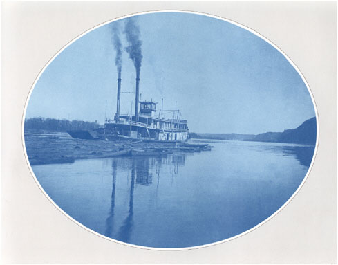
Timber rafts were floated down the Mississippi from Prescott Wisconsin to sawmills and markets to the south in 1885. The rafts were made up of cribs—16- by 32-foot sets of logs roped together. SOURCE: Neuzil (2001).
change to riparian systems across the country have been extensive, diverse, and persistent.
America’s rivers, streams, and lakes and their attendant riparian systems have been utilized for centuries, generally with limited knowledge about the environmental consequences of such actions on either current or subsequent generations. Many of the impacts to riparian systems have been directly or indirectly related to policies of proactive resource development that have dominated the history of this nation. An expanding population base coupled with an increasing standard of living has ensured a high and increasing demand upon the productivity not only of riparian areas, but also of all the nation’s natural resources. Continued population growth and increasing resource demands remain a dominant force in the national agenda. Even though large areas (e.g., national parks and national forests) have been set aside and policies developed to protect some of their natural resources, protection of other portions of the American landscape has been less stringent, less organized, and not always implemented. Riparian areas are characteristic of this latter situation.
Variable Riparian Area Protection
One of the areas where protection of natural resources has been a central theme nationally is forest law and policy (Committee of Scientists, 1999). Yet, even forestlands provide an example of how riparian areas have only recently assumed more explicit recognition and the variable nature of their protection. When Congress authorized the establishment of forest reserves in the Creative Act of 1891, the predominant reason for the legislation was to meet the request of municipalities and irrigation districts for watershed protection. In the Organic Act of 1897, the first listed purpose for establishing forest reserves (which subsequently became national forests) was that of “securing favorable conditions of water flows,” which has generally been interpreted as protecting upland watersheds from significant adverse effects. However, maintaining hydrologic connectivity and the integrity of riparian systems would seemingly be an important part of securing and sustaining favorable flow conditions. The Weeks Act of 1911 also emphasized watershed protection.
In the latter half of the twentieth century, legislation advocated multiple uses of national forests, but “without impairment of the productivity of the land” (Multiple-Use Sustained-Yield Act of 1960). Although in the National Forest Management Act (NFMA) of 1976, the production of timber and other resources were indicated as important multiple uses of federal forestlands, Congress emphasized that “the Forest Service has both a responsibility and an opportunity to be a leader in assuring that the Nation maintains a natural resource conservation posture that will meet the requirements of our people in perpetuity.” Congress further indicated a need to ensure that “protection is provided for streams, streambanks, shorelines, lakes, wetlands, or other bodies of water from detrimental changes in water temperatures, blockages of water courses, and deposit of sediment.” Although riparian areas are not explicitly identified in NFMA, it has been increasingly accepted in agency practice that water resources protection cannot occur without the protection of riparian systems.
Although the protection afforded many riparian areas has increased in recent years on national forests and grasslands, lands administered by the Bureau of Land Management (BLM), state lands, and industrial forestland and private woodlands, loss and degradation of riparian systems throughout the much of United States continue. If the ecological, economic, or cultural assets of riparian systems are not more fully identified, understood, and appreciated by society, there will likely be little incentive or desire by individuals, communities, or the nation to protect and maintain these areas.
Growing Recognition of the Term “Riparian”
The term “riparian,” which has long been used in the United States, has generally been limited to policy and regulations associated with water law. A
“riparian” water right generally provides a landowner whose property borders a stream, river, or other body of water the right to use a portion of that water for irrigation, human consumption, or other purposes. In the eastern United States, “riparian rights” were used as a basis for allocating water, while in the western United States, where water is relatively scarce, the doctrine of “prior appropriation” was typically used. In both situations, the vast majority of water rights were conferred long before the ecological importance of riparian areas and their dependence upon flow regimes were documented and understood. It has only been during the last 30 years that there has been a dramatic increase in the number of published studies that address riparian issues. Thus, only recently have scientists, from a variety of disciplines, begun to explore and better understand the widespread importance of these systems for a range of ecological functions and human values.
To illustrate the increase in recent scientific literature about riparian areas, three databases were investigated. The first was the Library of Congress where a keyword search for all “riparian” citations, by decade, was undertaken for the period 1900 through 1999. Of the 210 documents identified by this keyword search, approximately 37 percent addressed ecological topics, 52 percent addressed water law and policy issues, and 10 percent were indeterminate in their emphasis. Because some of the citations represent symposium proceedings and conferences, a relatively large number of riparian and riparian-related publications could be represented by any given citation. Hence, the actual number of publications contained within the Library of Congress database is much larger than the overall numbers would indicate. Interestingly, of the U.S. riparian citations identified as having an ecological emphasis, only 5 percent were published prior to 1970 (Figure 1-1).
The second database queried was one developed jointly by the U.S. Forest Service (USFS) and the University of Washington (http://www.lib.washington.edu/Forest/). This database contains over 11,000 references to journal articles, government documents, monographs, conference proceedings, and other papers associated with streams, rivers, streamside vegetation, water quality, and other riparian-related topics. This database has a western bias because most national forests and rangelands are located in the western states, and many ecological studies associated with western streams and rivers have occurred in recent decades. Even so, the database contains citations from every state and a number of foreign countries (see Figure 1-2). As with documents listed by the Library of Congress, only a small portion (less than 10 percent) of the references included in the USFS/University of Washington database were published prior to 1970. Of those references that explicitly utilized the term “riparian” as a keyword identifier (approximately a fifth of the total), fewer than 5 percent were published before 1970.
A third compilation of riparian and wetland publications for the western United States (Koehler and Thomas, 2000) reveals similar temporal trends in the
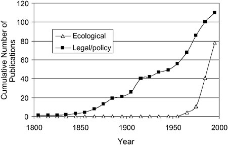
FIGURE 1-1 Cumulative number of citations, by date of publication, obtained from a search of the Library of Congress catalog using the term “riparian” for a keyword, December 2000.
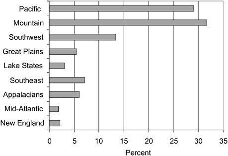
FIGURE 1-2 Percentage of riparian and riparian-related publications, by region, from the U.S. Forest Service and University of Washington (College of Forest Resources) database as of December 2000.
number of publications (Figure 1-3). Furthermore, it was only in 1985 that the “First North American Riparian Conference” was held in the United States (Johnson et al., 1985).
Trends revealed by these databases are consistent with the relatively recent mushrooming of scientific information that specifically addresses riparian and riparian-related topics. Although much fundamental biological, geomorphic, and hydrologic research undoubtedly preceded this recent period of riparian research and provided a useful context for understanding many riparian issues, the last few decades have shown an exceptional trend toward increased research productivity on a wide variety of riparian topics. These trends imply that many current natural resource managers, city councilors, state and federal politicians, and the general public acquired their educational backgrounds during a period when riparian issues, functions, and values were likely never mentioned or discussed, much less emphasized. Even in today’s era of general environmental awareness and concerns, educational programs have been slow to incorporate subject matter that addresses the importance of riparian functions and values.
DEFINITION OF “RIPARIAN”
The lack of a consistent definition for “riparian” has been identified as a major problem of federal and state programs that might manage and protect these areas (Steiner et al., 1994). As discussed in detail below, riparian areas generally
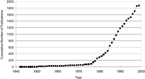
FIGURE 1-3 Cumulative number of riparian/wetland publications, by date of publication, for the western United States. SOURCE: Koehler and Thomas (2000).
do not satisfy regulatory and other definitions of “wetland,” and thus are not encompassed by regulatory programs for wetland protection. A goal of this report is to develop a working definition of “riparian” that can be used to define those areas that require protection and explain the need for such protection.
Webster’s Ninth New Collegiate Dictionary defines riparian as “relating to or living or located on the bank of a natural watercourse (as a river) or sometimes of a lake or a tidewater.” The terms “streamside areas,” “streambanks,” and “bottomlands” are frequently used interchangeably with “riparian areas.” As one might expect, the simple dictionary definition has been expanded or altered innumerable times by scientists and others, frequently for specific purposes or to reflect certain disciplinary preferences. However, an informal survey of definitions from a wide variety of sources—some of which are compiled in Table 1-1—revealed some general traits that most definitions of “riparian” have in common.
Reference to location is the most frequent characteristic of definitions of “riparian.” Riparian areas are invariably defined as being directly adjacent to a waterbody, typically a stream. Definitions vary to the extent that they include all stream types, from perennial to ephemeral (see Box 1-1). Some are restricted to fresh waters, while others incorporate marine and estuarine waters as well. Although typically thought of in relation to streams and rivers, many “riparian” definitions (such as the dictionary definition above) include more static hydrologic regimes that incorporate lakes, estuaries, and other waters in addition to streams. Finally, expansive definitions include manmade waters, such as reservoirs and drainage ditches.
Hydrology is the primary emphasis of most definitions of wetlands and is also used to define riparian areas. Indeed, their proximity to water foreshadows the importance of hydrology in some definitions of riparian areas. However, not all definitions include hydrology, and those that do share little common language. The only statement universally found or strongly implied in various definitions is that riparian areas are wetter than adjacent uplands. More detailed hydrologic descriptions mention the extent and frequency of wetness, the width of wetted area (Freeman and Dick-Peddie, 1970), the role of flooding (Naiman et al., 1993), and interactions with the saturated zone. Although some have suggested definitions as precise as the 100-year floodplain (Lewis, 1996), such definitions have not received wide acceptance.
Regulatory and reference definitions for wetlands include vegetation and soil conditions. Although these factors may be somewhat less recognized for their importance to riparian areas, nonetheless many definitions of “riparian” include them. Soil characteristics and vegetation in riparian areas are frequently noted as being different or distinguishable from adjacent upland areas, particularly in semiarid and arid regions of the country. Invariably, the soils and vegetation of riparian areas are noted as being adapted to distinct hydrologic regimes such as elevated water tables, relatively high levels of soil moisture, or frequent flooding.
TABLE 1-1 Federal Agency Definitions of “Riparian”
|
Agency |
Definition |
|
Bureau of Land Management (1999) |
A riparian area is an area of land directly influenced by permanent water. It has visible vegetation or physical characteristics reflective of permanent water influence. Lake shores and stream banks are typical riparian areas. Excluded are such sites as ephemeral streams or washes that do not exhibit the presence of vegetation dependent upon free water in the soil. |
|
U.S. Fish and Wildlife Service (1998) |
Riparian areas are plant communities contiguous to and affected by surface and sub-surface hydrologic features of perennial or intermittent lotic and lentic water bodies (rivers, streams, lakes, or drainage ways). Riparian areas have one or both of the following characteristics: (1) distinctively different vegetative species than adjacent areas, and (2) species similar to adjacent areas but exhibiting more vigorous or robust growth forms. Riparian areas are usually transitional between wetlands and upland. |
|
U.S. Forest Service (2000) |
Riparian areas are geographically delineated areas, with distinctive resource values and characteristics, that are comprised of the aquatic and riparian ecosystems, floodplains, and wetlands. They include all areas within a horizontal distance of 100 feet from the edge of perennial streams or other water bodies…. A riparian ecosystem is a transition between the aquatic ecosystem and the adjacent terrestrial ecosystem and is identified by soil characteristics and distinctive vegetation communities that require free and unbound water. |
|
U.S. Forest Service Region 9 (Parrott et al., 1997) |
Riparian areas are composed of aquatic ecosystems, riparian ecosystems and wetlands. They have three dimensions: longitudinal extending up and down streams and along the shores; lateral to the estimated boundary of land with direct land-water interactions; and vertical from below the water table to above the canopy of mature site-potential trees. |
|
U.S. Department of Agriculture NRCS (1991) |
Riparian areas are ecosystems that occur along watercourses and water bodies. They are distinctly different from the surrounding lands because of unique soil and vegetation characteristics that are strongly influenced by free or unbound water in the soil. Riparian ecosystems occupy the transitional area between the terrestrial and aquatic ecosystems. Typical examples would include floodplains, streambanks, and lakeshores. |
|
U.S. EPA and NOAA Coastal Zone Management Act (EPA, 1993) |
Riparian areas are vegetated ecosystems along a water body through which energy, materials and water pass. Riparian areas characteristically have a high water table and are subject to periodic flooding and influence from the adjacent waterbody. These systems encompass wetlands, uplands, or some combinations of these two land forms. They will not in all cases have all the characteristics necessary for them to be classified as wetlands. |
|
Forest Ecosystem Management Assessment Team (FEMAT, 1993) |
Riparian Reserves are portions of watersheds where ripariandependent resources receive primary emphasis and where special standards and guidelines apply to attain Aquatic Conservation Strategy objectives. Riparian Reserves include those portions of a watershed required for maintaining hydrologic, geomorphic, and ecologic processes that directly affect standing and flowing waterbodies such as lakes and ponds, wetlands, and streams. |
|
BOX 1-1 Although there are no universally accepted definitions for perennial, intermittent, or ephemeral stream types, most definitions include or imply the following characteristics (Hewlett, 1982; Art, 1993; Comín and Williams, 1994; Nevada Division of Water Planning, 1999). Perennial reaches of streams receive substantial groundwater inputs and generally flow continuously throughout the year. Their flows can vary widely from year to year and may dry up during severe droughts, although groundwater is generally near the surface. Perennial streams are found in both humid and arid regions, although in arid regions, the point of initiation for perennial reaches generally occurs further downstream. Intermittent stream reaches typically flow for several weeks or months each year when precipitation and associated groundwater inputs are relatively high. The timing of the flow and drying of intermittent streams is broadly predictable on a seasonal basis. Though sometimes associated with arid and semiarid climates, intermittent streams are well represented in humid regions. Ephemeral portions of streams flow only in direct response to precipitation. Thus, their flow is as unpredictable as the rainfall events that drive them. Because the channel of ephemeral streams is generally well above the water table, these streams flow for only a few hours or days following a storm of sufficient magnitude to produce overland flow. Many of the dry washes or arroyos of the more arid regions of North America may be classified as ephemeral streams. |
Descriptions of other biota, particularly assemblages that are unique within a landscape, are also sometimes included in definitions of riparian.
Finally, one of the most prevalent characteristics of definitions is the concept of riparian areas as gradients. Occupying the space between land and water, these areas are characterized by multiple transitions in soil, biota, and hydrology. Some scientists have described riparian areas as “ecotones” or interfaces between terrestrial and aquatic ecosystems (Gregory, 1997), while others have embraced riparian ecosystems as landscape units comprising an array of zones that extend from aquatic to upland environments (Brinson et al., 1981). In either case, riparian areas clearly are characterized by gradients in environmental conditions, ecological processes, and species that make it difficult to assign them discrete boundaries (Naiman and Décamps, 1990).
It should be noted that for management and regulatory purposes, riparian areas are frequently given distinct spatial boundaries in order to achieve specific goals and are thereby called “riparian zones” or “riparian management areas.” Such management designations incorporate inherent trade-offs between proportions of riparian functions included within and outside of the boundaries of the zone.
The working definition developed in this report is broad in the sense that it encompasses all the characteristics mentioned above, including reference to location, hydrology, vegetation, soils, and the concept of gradients:
Riparian areas are transitional between terrestrial and aquatic ecosystems and are distinguished by gradients in biophysical conditions, ecological processes, and biota. They are areas through which surface and subsurface hydrology connect waterbodies with their adjacent uplands. They include those portions of terrestrial ecosystems that significantly influence exchanges of energy and matter with aquatic ecosystems (i.e., a zone of influence). Riparian areas are adjacent to perennial, intermittent, and ephemeral streams, lakes, and estuarine–marine shorelines.
This definition is consistent with other definitions developed by interdisciplinary groups of scientists with expertise in riparian issues. For example, Ilhardt et al. (2000) describe riparian areas as “three-dimensional ecotones of interaction that include terrestrial and aquatic ecosystems, that extend down into the groundwater, up above the canopy, outward across the floodplain, up the near slopes that drain to the water, laterally into the terrestrial ecosystem, and along the water course at a variable width.” Lowrance et al. (1985) defines riparian areas as “a complex assemblage of plants and other organisms in an environment adjacent to water. Without definite boundaries, it may include streambanks, floodplain, and wetlands … forming a transitional zone between upland and aquatic habitat. Mainly linear in shape and extent, they are characterized by laterally flowing water that rises and falls at least once within a growing season.” Even programs with disparate goals have developed similar definitions of “riparian.”
Over the last 15 years, several federal agencies have developed considerably narrower definitions of “riparian” for application to their programs, as summarized in Table 1-1. Most definitions reflect the particular goals of individual agencies, including mandates to protect, manage, or restore riparian areas (e.g., BLM and USFS) and to map riparian areas, a responsibility of the U.S. Fish and Wildlife Service (FWS).
It is useful to define two terms sometimes used interchangeably with “riparian.” Almost all rivers have floodplains—aggraded reaches composed of complex bed sediments (alluvia) where flood waters spread out laterally. Clearly part of riparian areas, floodplains are dynamic structures composed of the channel system and adjacent depositional levees, interfluvial bars and low-lying, depositional shelves, often with ridge and swale topography reflecting backfilling of ancient river channels. A river or stream corridor generally refers to riparian areas and their adjacent waterbodies as a unit defined longitudinally from headwaters to the ocean. Figure 1-4 is a schematic of a stream corridor that shows the many interconnections between its different components. Because floodplains are porous and contain aquifers that are closely linked to and controlled by the channel system, waterbodies and their riparian areas are linked longitudinally, vertically, and horizontally—not just by the movement of water and sediments, but also by the movement of biota (Stanford and Ward, 1993).
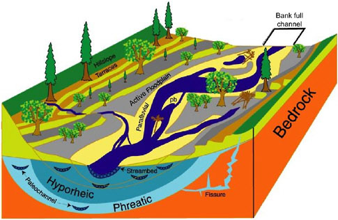
FIGURE 1-4 Idealized view of an alluvial river corridor showing the longitudinal (upstream–downstream), vertical (interstitial), and lateral (floodplain) dimensions that interact both hydrologically and ecologically. The riparian area includes the channel system, its floodplain, and the transition zone into the uplands. An alluvial aquifer underlies the channel and includes both a hyporheic zone and a deeper phreatic zone of groundwater. The phreatic zone contains groundwater that has had no contact or mixing from surface sources for very long time periods, often hundreds of years or longer. In contrast, in the hyporheic zone river water moves rapidly (on the order of days) through surficial alluvia characterized by very high hydraulic conductance. Other terms (parafluvial and bank-full) and interactions are described in detail in Chapter 2. pb = point bar. SOURCE: Adapted from Stanford (1998).
DISTINGUISHING RIPARIAN AREAS FROM OTHER AREAS
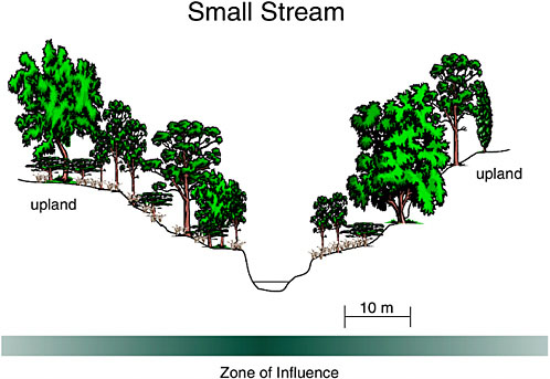
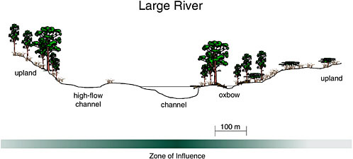
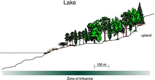
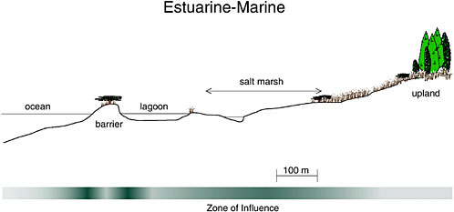
Another way of characterizing riparian areas is to identify what they are not and to contrast them with other adjacent land and water units. The definition in the preceding section describes riparian areas as “zones of influence” between aquatic and terrestrial areas. As such, riparian areas encompass some or all of the wetlands in a typical landscape setting, but they also include portions of adjacent aquatic and upland environments. Figure 1-5(A) shows a “generic” riparian zone of influence in detail; Figures 1-5(B–E) illustrate this zone of influence in small stream, river, lake, and estuarine-marine settings and approximate the scale at which the zone applies.
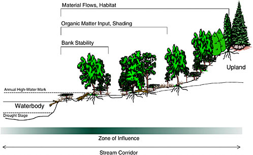
FIGURE 1-5(A) Schematic of a generic riparian area (A) showing a zone of influence relative to aquatic and upland areas. Four common riparian settings are illustrated: (B) a small stream, (C) a large river, (D) a lake, and (E) an estuarine–marine setting. Horizontal scales differ and are provided for perspective. The intensity of riparian influence is depicted with shading. “Material flows” refers to energy, organic matter, water, sediment, and nutrient flow. SOURCE: Adapted from Ilhardt et al. (2000).
Riparian Areas Versus Aquatic Ecosystems
Riparian areas are differentiated from aquatic ecosystems, wetlands, and uplands based on the same characteristics—hydrology, soils, and vegetation—used to define them. With regard to vegetation, riparian areas are normally dominated by woody plants (e.g., trees), grasses, and emergent herbaceous plant cover, in contrast to aquatic ecosystems where these plant types are absent. Rather, aquatic plants commonly found in North America include bullrushes and arrow-head in the shallower waters, water lilies in still deeper water with little current, and submerged aquatic plants (e.g., pondweed, milfoil, coontail, waterweed, and bladderwort), some of which tolerate moderate current velocities.
Although riparian areas and aquatic ecosystems obviously differ in their moisture regimes and water depth, it is difficult to identify a boundary that can be used consistently to separate them. In fact, definitions of riparian may include intermittent to permanent aquatic environments, particularly in headwater streams where the vegetated portions of riparian areas provide the aquatic portion with organic matter, shade, fluvial structure, and biotic exchanges. [Some definitions of wetland ecosystems (and deepwater habitats) extend to two meters of water depth (Cowardin et al., 1979) and even to six meters in marine environments (Scott and Jones, 1995)].
In the transition from headwater to larger streams, there is a tendency for flooding to be more protracted and less abrupt because of the cumulative effects to the hydrograph of multiple tributaries originating from regions differing in the quantity and timing of flow. Floodplains become more expansive in a downstream direction and, in some cases, wetter (Rheinhardt et al., 1998). Ultimately riparian areas of rivers grade into coastal estuaries where tidally driven hydrologic regimes and salinity combine to support estuarine riparian areas.
In anticipation of practical reasons for identifying an aquatic boundary, especially for large rivers, lakes, and estuaries, the following perspective is offered. The aquatic boundary of riparian areas could be established where permanent water begins. For bodies of water that have relatively constant elevations, such as estuarine shorelines influenced by slowly changing sea level, a boundary such as mean high tide or mean low tide is relatively easy to identify. For waterbodies with relatively large fluctuations such as streams, “permanence” is a relative term. Just as it is conventional to assign return periods or frequencies to flood elevations for streams, the same approach could be used to establish a return period for a permanence level during drought—e.g., the low level that would occur at a frequency of every ten years. For ephemeral and intermittent streams, this low stage lies below the channel, and thus the riparian area using this criterion would include the entire streambed and underlying alluvium. (This approach to delineating the zone of influence is consistent with the fact that forest canopies shade the entire stream width of many intermittent streams.) For perennial streams and lakes, a zone of influence could include aquatic portions shaded by riparian
vegetation or even a distance equivalent to the height of a canopy tree. For the shoreline of some lakes (e.g., the Great Lakes), levels fluctuate over a multi-year cycle, causing the boundary of the riparian area to migrate back and forth.
Riparian Areas Versus Wetlands
Two definitions of wetlands provide a useful starting point for differentiating them from riparian areas. One is the jurisdictional, or legal, definition used as the basis for delineating wetlands in the U.S. Army Corps of Engineers regulatory program (WES, 1987):
The term “wetlands” means those areas that are inundated or saturated by surface or groundwater at a frequency and duration sufficient to support, and that under normal circumstances do support, a prevalence of vegetation typically adapted to life in saturated soil conditions. Wetlands generally include swamps, marshes, bogs, and similar areas.
This definition highlights three factors—water, vegetation, and soils—used to characterize wetlands. In practice, a number of primary and secondary field indicators are used to identify wetlands, as described in the Corps’ manual. These indicators constitute criteria that are related to one or more of the three factors. They are prone to vary geographically, which results in the need for regionalization of the manual through supplementary materials, as discussed in NRC (1995). The NRC report found the wetland definition and the delineation approach to be scientifically sound even though they were developed specifically for regulatory purposes with inevitable policy overtones that govern their application.
NRC (1995) provides a reference definition of “wetland” to which specific regulatory definitions can be compared. Although the NRC’s definition is consistent with the three criteria mentioned above, it recognizes hydrologic conditions as paramount because they give rise to the diagnostic features of hydric soils and hydrophytic vegetation. NRC (1995) defines “wetland” as follows:
A wetland is an ecosystem that depends on constant or recurrent, shallow inundation or saturation at or near the surface of the substrate. The minimum essential characteristics of a wetland are recurrent, sustained inundation or saturation at or near the surface and the presence of physical, chemical, and biological features reflective of recurrent, sustained inundation or saturation. Common diagnostic features of wetlands are hydric soils and hydrophytic vegetation. These features will be present except where specific physicochemical, biotic, or anthropogenic factors have removed them or prevented their development.
In both definitions, the emphasis is on minimum conditions that characterize a wetland–upland boundary (i.e., “sufficient to support” and “minimal essential characteristics”) rather than on describing the full wetness gradient. With empha-
sis on the dry end of the gradient, a point in the landscape is identified between wetter (definitely wetland) and drier (definitely upland) conditions.
In contrast to most wetland definitions, a balanced characterization for riparian areas should treat the riparian area as a whole and not place undue emphasis on either its driest or its wettest margin. Moreover, fundamental characteristics of riparian areas are their zonal nature and their position in the landscape. Except for the FWS definition that refers to wetlands as “lands transitional between terrestrial and aquatic systems” (Cowardin et al., 1979), most wetland definitions do not incorporate concepts of zonation and landscape position. To omit these characteristics of riparian areas, however, would be to disregard two of their diagnostic characteristics.
Hence, compared with wetlands, riparian areas are both more expansive from some perspectives and more restrictive from others. They are more expansive because they may include not only portions of wetlands, but also nonvegetated portions of point bars. At the dry end, they encompass terrestrial areas that do not necessarily require inundation and saturation near the surface, as do wetlands. Riparian areas are more restrictive than wetlands because they are confined to specific geomorphic settings of streams, lakes, and estuarine-marine environments. Extensive peatlands or flatwood wetlands, for example, would not be considered riparian areas because most of them lack landscape attributes of linear configuration, distinct zonation, and adjacency to waterbodies.
Riparian Areas Versus Uplands
Unlike uplands that receive precipitation as their principal or only source of water, moisture in riparian areas may be supplied from both adjacent uplands and aquatic ecosystems. Water enters riparian areas from uplands in the form of groundwater discharge, shallow subsurface flow, and overland flow (see Chapter 2). From the aquatic side, water is supplied by overbank flow, infiltration through adjacent channel banks (bank storage), and by hyporheic flow from alluvium upstream. Unlike uplands, floods are important agents of geomorphic change in riparian areas, eroding soils and sediments from some parts of the riparian area while depositing them in others to create new geomorphic surfaces. The lateral transport of materials to riparian areas from outside the floodplain constitutes a fundamental difference between riparian areas and uplands.
These hydrologic conditions are clearly reflected in the distinctive vegetation of riparian and upland areas. First, the flooding regimes of riparian areas select for disturbance-tolerant species, and they may also constrain colonization of riparian areas by flood-sensitive species. Second, because riparian areas exist where depth to the water table is relatively shallow, specific assemblages of shrubs and trees withdraw water directly from the saturated area (Robinson, 1958), a phenomenon not generally possible in uplands. In low-elevation settings
of arid landscapes, riparian areas may be the only place where cottonwoods and willows are present, and the only place where mesquite grows vigorously (Stromberg et al., 1996). These areas may extend hundreds of meters from stream channels on terraces where surface connections are entirely absent but shallow groundwater is available to plants. Riparian forests persist in arid regions where there is insufficient precipitation to support upland forests (Brinson, 1990), thus creating a distinct boundary. In humid climates, water availability is not as crucial, and the boundary between uplands and riparian areas is not always easy to distinguish. Nonetheless, there are distinct assemblages of trees in humid riparian areas, including some species of willow, alder, cypress, tupelo, and sycamore (Hupp and Osterkamp, 1985). In drainage basins with relatively fine sediments, riparian tree species are more likely to be distinguished by their ability to withstand the stresses of sediment anoxia than a requirement for a dependable source of groundwater (Wharton et al., 1982; Friedman and Auble, 2000).
Steep slopes, such as rock escarpments or abrupt sediment banks, present a more ambiguous case because there may be no active hydrologic connection with the adjacent stream, river, or lake for the majority of the riparian area. Nevertheless, riparian functions remain strong, with pronounced flows of biotic and abiotic materials between aquatic and terrestrial ecosystems. Such “upland” riparian areas provide important habitat for a variety of species that respond to topography, water-influenced microclimates, and the presence of a natural movement corridor, among other factors. In areas with steep slopes, distinguishing between riparian and the non-riparian areas should be based on function. This can be justified because the zone of influence by moisture or disturbance alone may be quite narrow and insufficient to account for other influences. Consistent with the working definition of “riparian” developed in this report, which includes areas that “significantly influence exchanges of energy and matter with aquatic ecosystems,” the upper boundary of such riparian areas can be functionally identified by the potential for trees to contribute portions of their wood to a stream channel, should they fall in that direction.
SCOPE OF THE STUDY
This study is an outgrowth of the National Research Council’s (NRC) study on the Characterization of Wetlands (NRC, 1995). The major intent of that work was to identify both the strengths and weaknesses of current regulatory practice regarding wetlands. Beginning in the mid-1970s, the regulation of wetlands as “waters of the United States” under Section 404 of the Clean Water Act has elicited strong opposition by property rights advocates, developers, and landowners. Because portions of riparian areas contain “waters” and, as explained later, carry out many of the same functions as wetlands, questions on how riparian
areas should be managed are often very similar to those for wetlands. A brief background of how the wetland study came about provides historic context to the present study.
In order for a landowner to fill a wetland, the owner must request and receive a permit from the U.S. Army Corps of Engineers (Corps), with oversight authority provided by the U.S. Environmental Protection Agency (EPA). The first step is to identify the location of the wetland to be affected and its boundaries, for which technical manuals were developed to assist regulators in consistently applying delineation procedures in the field. Until 1989, the Corps and EPA had different manuals for this task. In order to provide more uniformity in the regulatory program, a new and revised manual—the “1989 Manual”—was produced by an interagency team of scientists (Federal Interagency Committee for Wetland Delineation, 1989).
In part as a result of its inconsistent application, landowners and developers perceived the 1989 manual as extending the reach of wetlands to include lands that previously had not been designated as wetlands. Further, opponents of the new manual complained that it had been adopted without public comment and that its application constituted a “taking of property” (without just compensation) (Kusler, 1992). In response, the White House released in August 1991 a document—1991 proposed revisions (56 Fed. Reg. 40,446; 10,991)—much different from the approach that the scientists had taken. Field testing found the 1991 proposed revisions not only to be technically wanting, but to propose a much narrower definition of wetlands. Unlike the 1989 Manual, the 1991 proposed revisions would substantially reduce the surface area of wetlands that would fall under jurisdiction of Section 404 of the Clean Water Act. The groundswell of complaints and other objections brought the issue of wetlands definition under scrutiny by Congress. Faced with the need to respond to public outcries from both sides, Congress ordered the Corps to revert to using a 1987 manual (WES, 1987) and mandated that the NRC study the situation and provide recommendations.
That NRC committee reviewed the science of wetland identification and delineation, identified the functions and values of wetlands, and examined the variation among wetland types. During this process, it became obvious that some areas of the landscape, especially riparian areas, were not always wet enough to be encompassed by any of the technical manuals or by the reference definition for wetlands. In other words, they did not have sufficient wetness to develop hydric soils and to support hydrophytic vegetation—key criteria (along with hydrology) necessary to define wetlands. These marginally dry areas were prevalent in arid and semiarid climates where wetlands are exceedingly rare, but were often in the same landscape position as floodplain wetlands of more humid climates. To a large degree, riparian areas perform many of the same functions as areas that are jurisdictional wetlands in more humid climates, such as water storage and conveyance, nutrient and sediment removal, and plant and animal habitat maintenance.
The committee considered the protection and maintenance of riparian areas important toward meeting the goals of the Clean Water Act. However, because the study commissioned by Congress was restricted to wetlands, any attempt to include riparian areas “would unreasonably broaden the definition of wetland and undermine the specificity of criteria and indicators that have developed around wetland delineation” (NRC, 1995). The following was one of the recommendations of the committee: “If national policy extends to protection of riparian zones pursuant to the goals of the Clean Water Act, regulation must be achieved through legislation that recognizes the special attributes of these landscape features, and not by attempting to define them as wetlands.” The purpose of the present study is to recognize and identify the attributes of riparian areas and make recommendations for managing and maintaining these attributes.
Chapter 2 describes riparian structure and how riparian areas affect water quality, provide habitat for fish and wildlife, and serve as corridors for species movement, among many other functions. The report explores these and other aspects of functioning, especially as they vary between climatic extremes of North America. Because of the importance of riparian areas in arid and semiarid regions of the nation, special attention is given to these locations. While riparian areas are also a fundamental part of more humid landscapes, they may not be as easily separated from their adjacent uplands as in arid regions. Nevertheless, principles that govern the functioning of riparian areas are broadly transferable across a wide variety of landscapes.
Knowledge of the status of riparian lands in the United States, both in quantity and quality, is fundamental to any management program that sets goals for improvement. This information should include whether the resource is increasing or decreasing over time, the geographic distribution of these changes, and, ideally, data on the condition of existing riparian areas. But even without detailed inventories on riparian resources nationwide, local knowledge of riparian condition provides clues to the types of impacts they have experienced. Dam and levee construction, cattle grazing, conversion to agricultural production, and withdrawal of water for domestic consumption, power generation, and irrigation are just a few examples. Chapter 3 comprehensively describes the general impacts of water resources development and other human activities on the condition and functioning of riparian areas. The current status of riparian lands in the United States is assessed in terms of overall increases or decreases in acreage, habitat condition, and other important trends.
In spite of an increasing wealth of scientific information, riparian policy issues are complicated by a long and complex history of changing land use and ownership, a proliferation of legal statutes that influence their development for various purposes, and a relatively recent overlay of environmental regulations. The complexity is a result, in part, of development of legislation over time with little attention to removing redundancies and avoiding conflicts. Because policy differs geographically at national and state levels, and jurisdictionally among
agencies, disputes are sometimes resolved in the courts. These issues are analyzed in Chapter 4, which describes the regulatory landscape surrounding riparian areas. Chapter 4 focuses on the differences between eastern and western regions and between public and private lands, as well as on the variability observed from state to state. It considers policy goals reflected in current laws and regulatory and nonregulatory programs for riparian areas and makes recommendations regarding the protection of these areas in the future. Programs of federal and state agencies particularly relevant to or dependent on riparian areas are highlighted.
Finally, Chapter 5 considers the management of riparian areas, which is confounded by many present-day conflicts regarding the functioning of riparian areas and by multiple desired uses of riparian land and water. The report describes our current scientific understanding of these conflicts and the additional scientific information needed to resolve them. Several management strategies, including dam re-operation and other hydrologic manipulations, design of riparian management systems for agriculture, grazing and forestry practices, and education, are explored for restoring, enhancing, and preserving riparian areas across the United States.
CONCLUSION
A large body of scientific information on riparian areas has developed over the last several decades documenting their importance as elements of regional landscapes. Early publications on riparian topics focused predominantly on water law. However, since 1970 there has been an explosion of information addressing ecological and hydrologic topics, processes and functions, aquatic and terrestrial wildlife habitats and food web support, aesthetics, production of goods and services, cultural and social values, and other topics related to riparian areas. As discussed in greater detail in Chapters 4 and 5, new scientific information about the structure, functioning, and importance of riparian areas should be included forthrightly in education at all levels and given full consideration in environmental regulatory and policy processes including decision-making.
REFERENCES
Art, H. W. 1993. The dictionary of ecology and environmental science. New York: Henry Holt and Co.
Brinson, M. M., B. L. Swift, R. C. Plantico, and J. S. Barclay. 1981. Riparian ecosystems: their ecology and status. FWS/OBS–81/17. Kearneysville, WV: U.S. Fish and Wildlife Service.
Brinson, M. M. 1990. Riverine forests. Pp. 87–141 In: Forested wetlands. A. E. Lugo, M. M. Brinson, and S. Brown (eds.). Amsterdam, The Netherlands: Elsevier.
Bureau of Land Management (BLM). 1999. Draft environmental impact statement for riparian and aquatic habitat management in the Las Cruces field office, New Mexico.
Comín, F. A., and W. D. Williams. 1994. Parched continents: our common future? In: Limnology now: a paradigm of planetary problems. R. Maralef (ed.). New York: Elsevier Science B. V.
Committee of Scientists. 1999. Sustaining the people’s lands: Recommendations for stewardship of the National Forests and Grasslands into the next century. Washington, DC: U.S. Department of Agriculture. 193 pp.
Cowardin, L. M., V. Carter, F. C. Golet, and E. T. LaRoe. 1979. Classification of wetlands and deepwater habitats of the United States. FWS/OBS-79/31. Washington, DC: U.S. Fish and Wildlife Service.
Culler, R. C. 1970. Objectives, methods, and environment—Gila River phreatophyte project, Graham County, Arizona. Washington, DC: U.S. Govt. Printing Office. 25 pp.
Environmental Protection Agency (EPA). 1993. Guidance specifying management measures for sources of nonpoint pollution in coastal waters. Washington, DC: EPA.
Federal Interagency Committee for Wetland Delineation. 1989. Federal manual for identifying and delineating jurisdictional wetlands. Washington, DC: U.S. Army Corps of Engineers, U.S. Environmental Protection Agency, U.S. Fish and Wildlife Service, and USDA Soil Conservation Service. Cooperative technical publication. 76 pp. plus appendixes.
Fish and Wildlife Service (FWS). 1998. A system for mapping riparian areas in the western U.S. Washington, DC: U.S. Fish and Wildlife Service.
Forest Ecosystem Management Assessment Team (FEMAT). 1993. Forest ecosystem management: an ecological, economic, and social assessment. Washington, DC: U.S. Department of Agriculture.
Freeman, and Dick-Peddie. 1970. Woody riparian vegetation in the Black and Sacramento Mountain Ranges, Southern New Mexico. The Southwestern Naturalist 15(2):145–164.
Friedman, J. M., and G. T. Auble. 2000. Floods, flood control, and bottomland vegetation. Pp. 219–237 In: Inland flood hazards: human, riparian, and aquatic communities. E. Wohl (ed.). Cambridge: University Press.
Gregory, S. V. 1997. Riparian management in the 21st century. Pp. 69–85 In: Creating a forestry for the 21st century: the science of ecosystem management. Kohm, K. A., and Franklin, J. F. (eds.). Washington, DC, and Covelo, CA: Island Press.
Hewlett, J. D. 1982. Principles of forest hydrology. Athens, GA: University of Georgia Press.
Hupp, C. R., and W. R. Osterkamp. 1985. Bottomland vegetation distribution along Passage Creek, Virginia, in relation to fluvial landforms. Ecology 66:670–681.
Ilhardt, B. L., E. S. Verry, and B. J. Palik. 2000. Defining riparian areas. Pg. 29 In: Riparian management in forests of the continental eastern United States. Verry, E. S., J. W. Hornbeck, and C. A. Dolloff (eds.). New York: Lewis Publishers.
Jensen, O. 1993. The American heritage history of railroads in America. New York: American Heritage/Wing Books. 314 pp.
Johnson, R. R., C. D. Ziebell, D. R. Patton, P. F. Ffolliott, and R. H. Hamre (eds.). 1985. Riparian systems and their management: reconciling conflicting uses. General Technical Report RM-120, Fort Collins, CO: USDA Forest Service. 523 pp.
Koehler, D. A., and A. E. Thomas. 2000. Managing for enhancement of riparian and wetland areas of the western United States: an annotated bibliography. General Technical Report RMRS-GTR-54. Ogden, UT: USDA Forest Service. 369 pp.
Kusler, J. 1992. Wetlands delineation: an issue of science or politics. Environment 34(7-11):29–37.
Lewis, W. M. 1996. Defining the riparian zone: lessons from the regulation of wetlands. In: At the water’s edge: the science of riparian forestry. Conference Proceedings June 19-20, 1995. Minnesota Extension Service. BU-6637-S.
Lewty, P. J. 1995. Across the Columbia Plain: railroad expansion in the interior Northwest, 1885–1893. Pullman, WA: Washington State University Press. 326 pp.
Lowrance, R. R., R. Leonard, and J. Sheridan. 1985. Managing riparian ecosystems to control nonpoint pollution. J. Soil Water Conserv. 40:87–91.
Maser, C., and J. R. Sedell. 1994. From the forest to the sea: the ecology of wood in streams, rivers, estuaries, and oceans. Delray Beach, FL: St. Lucie Press. 200 pp.
Naiman, R. J., and H. Décamps (eds.). 1990. The ecology and management of aquatic-terrestrial ecotones. Man and the Biosphere Series, Volume 4. Paris, France: UNESCO.
Naiman, R. J., H. Décamps, and M. Pollock. 1993. The role of riparian area corridors in maintaining regional diversity. Ecol. Appl. 3:209–212.
National Research Council (NRC). 1995. Wetlands: characteristics and boundaries. Washington, DC: National Academy Press.
Neuzil, M. 2001. Views on the Mississippi: the photographs of Henry Peter Bosse. Minneapolis, MN: University of Minnesota Press.
Nevada Division of Water Planning. 1999. Water words dictionary, 8th edition. Carson City, NV: Nevada Department of Conservation and Natural Resources.
Parrott, H. A., D. A. Marions, and R. D. Perkinson. 1997. A four-level hierarchy for organizing stream resources information. Pp. 41–54 In: Proceedings, Headwater hydrology symposium. Missoula, MT: American Water Resources Association.
Reisner, M. 1987. Cadillac desert: the American West and its disappearing water. New York: Penguin Books. 582 pp.
Rheinhardt, R. D., M. C. Rheinhardt, M. M. Brinson, and K. Faser. 1998. Forested wetlands of low order streams in the inner coastal plain of North Carolina, USA. Wetlands 18:365–378.
Robinson, T. W. 1958. Phreatophytes. U.S. Geological Survey Water Supply Paper 1423. 84 pp.
Rose, A. C. 1976. Historic American roads: from frontier trails to superhighways. New York: Crown Publishers. 118 pp.
Scott, D. A., and T. A. Jones. 1995. Classification and inventory of wetlands: a global overview. Pp. 3–16 In: Classification and Inventory of the World’s Wetlands. C. M. Finlayson and A. G. van der Valk (eds.). Dordrecht, The Netherlands: Kluwer Academic Publishers.
Stanford, J. A. 1998. Rivers in the landscape: introduction to the special issue on riparian and groundwater ecology. Freshwater Biology 40(3):402–406.
Stanford, J. A. and J. V. Ward. 1993. An ecosystem perspective of alluvial rivers: connectivity and the hyporheic corridor. J. N. Am. Benthol. Soc. 12(1):48–60.
Steiner, F., S. Pieart, E. Cook, J. Rich, and V. Coltman. 1994. State wetlands and riparian area protection programs. Environmental Management 18(2):183–201.
Stromberg, J. C., R. Tiller, and B. Richter. 1996. Effects of groundwater decline on riparian vegetation of semiarid regions: the San Pedro, Arizona. Ecological Applications 6:113–131.
U.S. Department of Agriculture Forest Service (USFS). 2000. Forest Service Manual, Title 2500, Watershed and Air Management. Section 2526.05. Washington, DC: USDA Forest Service.
U.S. Department of Agriculture Natural Resources Conservation Service. 1991. General Manual, 190-GM, part 411. Washington, DC: USDA NRCS.
WES Environmental Laboratory. 1987. U.S. Army Corps of Engineers wetlands delineation manual. U.S. Army Engineer Waterway Experiment Station Technical Report Y-87-1.
Wharton, C. H., Kitchens, W. M., and Sipe, T. W. 1982. The ecology of bottomland hardwood swamps of the Southeast: a community profile. FWS/OBS-81/37. Washington, DC: U.S. Fish and Wildlife Service. 133 pp.


