
1
Introduction
Florida Bay is a large, shallow marine ecosystem immediately south of the Everglades (Figure 1). It may be thought of as the marine extension of the Florida peninsula, beginning where the gently sloping land surface of the southern Everglades descends below sea level. It is bounded on the east and south by the Florida Keys and on the west by the Gulf of Mexico, and covers about 850 square miles (2200 square kilometers) including about 700 square miles (1800 square kilometers) within Everglades National Park. Much of the rest is in the Florida Keys National Marine Sanctuary. It is dotted with several hundred small islands, many of which are rimmed with mangroves.
The Physical System
The average depth of Florida Bay is less than one meter (CERP, 2001) and it is generally well mixed vertically. Shallow carbonate banks subdivide it into semi-isolated basins that restrict circulation, especially in the central and eastern zones (Fourqurean and Robblee, 1999). Its salinity is highly dependent on local rainfall and evaporation; cells of hypersaline water are common during the dry season. At the discharge locations of the Taylor Slough and C-111 basins (Figure 2) in the northeastern Bay, the salinity is much lower during the wet season than in the dry season.
The northern boundary, which represents the primary interface between the Bay and the upgradient ecosystems of the Everglades, is complex (Figure 2). Water carrying dissolved and particulate matter flows in shallow sloughs that become channelized through broad bands of creeks as they near the coastline (Rudnick et al., 1999). Fresh water enters the Bay primarily as channel flow fed by Taylor Slough and to a lesser extent the C-111 canal (a major water conveyance canal, now intentionally breached, on the southeast edge of Everglades National Park) to approximately 20 microtidal creeks that cut through the Buttonwood Embankment and as sheetflow across marl prairies of the southern Everglades (Figure 1) (Davis et al. 2002; CERP, 2001). Groundwater discharge along this boundary is poorly quantified but is primarily saline (Fitterman and Deszcz-Pan, 2001). The quantity and distribution of material exchanges between the Everglades watershed and the Bay are not well understood (Sklar and Browder, 1998).
The western boundary of the Bay is open to the Gulf of Mexico (Fourqurean and Robblee, 1999). A west-to-east (or NW-to-SE) current generated by winds, tides, and the broader circulation of the Gulf of Mexico, Caribbean Sea, and Atlantic Ocean generally prevails across the Gulf-Bay boundary (Lee et al., 2002; Smith and Pitts, 2002). It is, therefore, very probable that some of the water and nutrients discharged from Shark River Slough (Figures 1 and 2) migrate south around Cape Sable, across this boundary, and into the Bay (Boyer et al., 1999). Net outflow to the Atlantic Ocean occurs along the southern boundary through passes between the Florida Keys (Smith and Pitts, 2002). The volumes are lower now than they were before construction of the Flagler Railroad, which extended from the mainland to Key West, and was completed in 1912.
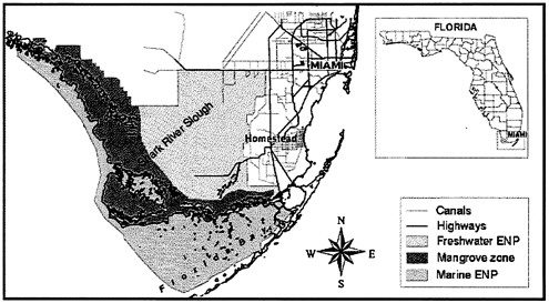
FIGURE 1 Location of Florida Bay with respect to other major features of South Florida. (Note: ENP is Everglades National Park.) Source: Florida Coastal Everglades Long Term Ecological Research, 2002.
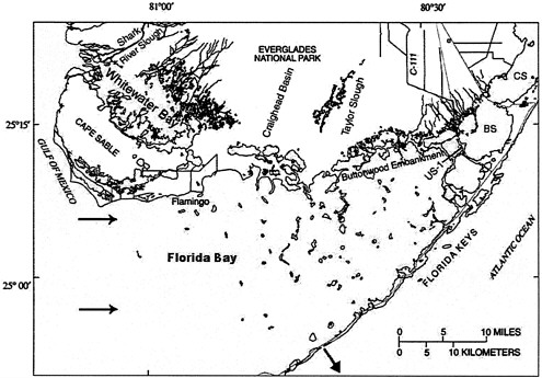
FIGURE 2 Detail map of Florida Bay. Arrows indicate generalized circulation pattern through Florida Bay (after Smith and Pitts, 2002). (Note: BS is Barnes Sound; CS is Card Sound. Biscayne Bay is to the northeast of Card Sound, off the map). Source: Hittle, 2001.
Nutrients in the Bay
In terms of nutrient status and water chemistry, Florida Bay can be divided into three zones (Boyer et al., 1997). These are (a) a western zone of fairly stable marine conditions and nitrogen:phosphorus ratios in seston (i.e., in particulate matter in the water column) approximating the Redfield ratio (indicating balanced conditions relative to the nitrogen and phosphorus needs of the phytoplankton community); (b) a central zone that is often hypersaline, has high nitrogen:phosphorus ratios for seston, and high levels of dissolved organic matter; and (c) an eastern zone with variable salinity, high concentrations of dissolved inorganic nitrogen, and even higher nitrogen:phosphorus ratios for seston. These high nitrogen:phosphorus ratios suggest that phytoplankton growth in at least the eastern Bay is limited by phosphorus.
For at least several decades until the late 1980s, most of Florida Bay was characterized by clear water and dense seagrass (largely Thalassia testudinum, or turtle grass) meadows (CERP, 2001), albeit with some interannual variation (Halley, 2002). However, beginning around 1987, the seagrass beds began dying in central and western Florida Bay (Fourqurean and Robblee, 1999), for reasons that remain a subject of scientific controversy. Several ecological changes that may be related to the die-off have ensued in the Bay. Water in central and western Florida Bay, which had been “gin clear” during recent decades, has become turbid, in part because of phytoplankton blooms and in part because of increased sediment resuspension (Zieman et al., 1999). A decline in fishing success for some commercial and recreational species that use the Bay as a juvenile nursery habitat also was reported in that period (CERP, 2001).
Linkages with the Everglades
Florida Bay is intimately linked to the Everglades from both hydrologic and public policy perspectives. From a hydrologic perspective, some of the water draining from the Everglades flows directly into Florida Bay, supplying it with freshwater runoff that is high in total nitrogen (Brand, 2002) and low in total phosphorus (Rudnick et al., 1999). Other freshwater drainage appears to reach the Bay indirectly after it is discharged from Shark River Slough and mixes with southwest Florida shelf water. The Everglades has been greatly altered during the past century by human activity, including the construction of canals, levees, pumps and control structures, and conversion of land to agricultural and urban uses. This has led to vast ecological and hydrologic changes within the Everglades, including degradation of water quality, nutrient enrichment, landscape fragmentation, invasion by exotic species, declines in native plant and animal species (McPherson and Halley, 1996), and an overall loss of about half of the original wetland area (Davis et al., 1994). Because of the intimate hydrologic connection between the Everglades and the Bay, restoration of the Everglades most likely will affect conditions in the Bay.
From a public policy perspective, Florida Bay is connected with the rest of the Everglades system because it is a part of Everglades National Park and is included in the Comprehensive Everglades Restoration Plan (CERP). CERP planners acknowledge that many questions about the Bay and its relationship to the Everglades have no definitive answers at present. The CERP therefore recommended that the Florida Bay & Florida Keys Feasibility Study (FBFKFS) be conducted to assess the current conditions of the Bay and to determine the modifications needed to restore it (CERP, 2001). The FBFKFS is being conducted under the authority of the Water Resources Development Act (WRDA) of 1996, which allows for continuation of studies and analyses that are necessary to further the CERP (CERP, 2001).
Current Research and Oversight
Research in Florida Bay is carried out under the aegis of many academic and governmental institutions. The Florida Bay and Adjacent Marine Systems Science Program (http://www.aoml.noaa.gov/flbay/) is a collaborative effort of federal, state, and local agencies that conduct and sponsor closely complementary research, monitoring, and modeling projects on the Bay ecosystem. The program also provides a valuable mechanism for meetings of research teams, and it sponsors topical workshops and the important Florida Bay and Adjacent Marine Systems Science Conferences, the most recent of which (April 2001) provided the impetus for this report.
A Program Management Committee (PMC), composed of representatives of 11 state and federal agencies, guides the program. The PMC also provides for independent expert review through the Florida Bay Science Oversight Panel, as defined in the 1994 interagency science plan (Armentano et al., 1994). That plan defined the Panel’s role to include both technical and management review of program development, quality of research, modeling, and monitoring. Ad hoc advisory panels of experts in specialized subject areas also are formed from time to time. Reports of the Science Oversight Panel, along with many other reports on Florida Bay, may be found at http://www.aoml.noaa.gov/ocd/sferpm/oid.html.
Many academic institutions are involved in Bay research, most of which is funded by the PMC agencies. Some now also collaborate through the Florida Coastal Everglades Long Term Ecological Research (FCE LTER) program, which began in 2000. Research associated with the FCE LTER focuses on the coastal Everglades to investigate how nutrient availability and cycling interacts with the hydrologic regime to potentially control ecosystem structure and function (http://fcelter.fiu.edu/).
Report Objective and Overview
This report evaluates scientific components of the Florida Bay studies and restoration activities that potentially affect the success of the overall CERP. It deals with scientific aspects of Florida Bay that feed back to the Everglades components of the CERP and are integral to the success of the overall plan. In particular, it focuses on the potential long-term effects of Everglades restoration on the nature of the Bay. The report reflects discussions and reviews of poster presentations and abstracts from the April 2001 Florida Bay Science Conference and a review of relevant peer-reviewed literature.
Chapter 2 of this report describes the potential effects of the CERP on Florida Bay, specifically addressing the question: will increased flows of water deemed necessary to restore terrestrial and wetland habitats in the Everglades contribute to the restoration and enhancement of Florida Bay or will they have detrimental effects on the Bay ecosystem? Chapter 3 elaborates on the kinds of research that will be required to shed light on this question. Chapter 4 summarizes the committee’s conclusions and recommendations.


