
Executive Summary
Water is fundamental to human existence. The United States has an extensive infrastructure for withdrawing surface and groundwater for public water supply, industrial and commercial use, irrigated agriculture, and livestock and domestic use and for cooling thermal power plants. The objectives of the U.S. Geological Survey (USGS) National Water-Use Information Program (NWUIP) are to quantify the nation’s use of water and to develop and disseminate water use information at the local and national levels. To meet these objectives, USGS water use specialists work with state and local agencies that collect water use data for many purposes, such as supporting regulatory programs, fostering better water management, and determining of customer charges for water.
The term water use refers to all instream and offstream uses of water for human purposes from any water source. Instream use is a water use that takes place without water being withdrawn from surface or groundwater. Offstream use is use of water that is diverted from surface water sources or withdrawn from groundwater sources (a withdrawal in either case) and is conveyed to the place of use. This water is either lost to the system (consumptive use) or returned to surface or groundwater bodies (return flow), possibly with losses in transit (conveyance loss). Between withdrawal and return, the water may be delivered (to a public supplier, a water user, or a wastewater treatment plant) and then released one or more times.
NWUIP’s principal product is a national summary of water use, produced every five years, that synthesizes county-level data for a five-year period. The year 2000 report will be the 11th five-year summary of this 50-year series. These reports provide the only nationally consistent, policy-relevant information on the status and trends of water use for the country.
However, the NWUIP faces many challenges. The NWUIP is the only USGS water resources program in which the Survey does not have the principal responsibility for primary data collection. Instead, the USGS relies on data of mixed quality, collected by many different organizations. For many of these data sources, the Survey can neither modify nor control the quality and accuracy of these data. The NWUIP is largely funded through the USGS Cooperative Water (Coop) Program. These funds are generally unavailable in states making little effort to collect water use data. It is therefore not surprising that the quality of water use data varies considerably from state to state.
Recognizing these challenges as well as the growing need for consistent national water use information, the USGS asked the National Research Council (NRC) to help determine the best approach for the future of the NWUIP. This report responds to that request.
In carrying out this study, the NRC Committee on USGS Water Resources Research considered basic questions about the nature of water use, the water use information needed in the United States, and the USGS’s role in generating and disseminating that information. By studying state water use data collection and estimation programs, by analyzing data from the national water use summaries, and by examining parallel activities of other federal agencies, the committee arrived at a new vision for the future NWUIP.
GOALS FOR WATER USE INFORMATION
What kind of national water use information program is needed, and what role should the USGS play in that program? The committee concluded that such a program is needed in the United States to meet three primary goals:
-
Maintain a comprehensive national water inventory. With neither management nor regulatory responsibilities, the USGS is the only federal source of unbiased, science-based water resource information. The USGS inventories the nation’s surface and groundwater resources and studies the processes affecting them. A national water use information program is essential for understand the effects of spatial and temporal patterns of water use on the quality, availability, and sustainable use of these resources.
-
Help assure the nation’s water supply. The USGS’s contribution to maintaining the nation’s water supply requires continued focus on water use. Some of the most rapidly growing states, such as Nevada, are the most arid. Periodic droughts strain the capacity of water-supply systems, and climate change increases the uncertainty of future water conditions. Science-based assessments of the nation’s water supply are therefore essential, and this need will become more intense for management and policy decisions in the future.
-
Help preserve water quality and protect ecological resources. The quality and quantity of water are inseparable; both profoundly influence aquatic
-
ecosystems. An example is wastewater discharge, which alters the receiving water quality and affects the downstream environment. The USGS’s role in protecting aquatic and riparian ecosystems links its Water Resources and Biological Resources Divisions and requires detailed knowledge of water use.
The NWUIP is the nation’s only comprehensive source of information on the status and trends of water use. The USGS is uniquely suited to provide this essential national information, working with its state-level cooperative partners and with other federal agencies. The committee identified substantial opportunities to enhance the activities and relevance of the NWUIP through a conceptual framework that emphasizes the integration of water use with the USGS’s water resource programs.
CONCEPTUAL FRAMEWORK
It is essential to define an appropriate conceptual framework that links water use to its impact on water resources. The principal product of the NWUIP has been its five-year national estimates of aggregated water use, compiled primarily at the county and state levels. However, underlying these aggregated estimates is a more detailed site-specific description of water use, wherein each water withdrawal location may be tabulated, characterized, and quantified. At this level, the source of surface water or groundwater at each water use site can be identified, establishing the link between water use and water resources. The committee was impressed by the increasing availability of geospatial information on water resources generated by state regulatory programs, the USGS, and other federal agencies. In these programs, tabular data inventories describing water facilities are converted into mapped locations with attached attributes. This trend represents a rich and timely opportunity for systematically incorporating within the NWUIP consistent state and national data on water-using facilities.
These considerations led the committee to a conceptual framework for the NWUIP depicted in Figure ES.1. The physical system within which water use takes place is termed herein the infrastructure water system, described by locations of water withdrawals, by water discharges, and by the water facilities (pumping stations, treatment plants, water conveyance systems) by which water moves through the landscape in constructed water systems. The natural water system of streams, rivers, lakes, aquifers, and watersheds coexists with the infrastructure water system, and exchanges of water occur between them, primarily where water is withdrawn and discharged. In this framework, the NWUIP would be supported by water use data, water use estimation, and integrative water use science. Water use data are measurements or estimates of the amount of water used at a site or for a region. Water use estimation consists of random sampling methods, statistical inference, and other indirect methods to estimate water use at a site or for a region. Integrative water use science refers to the hypothesis-driven investigation of the behaviors and phenomena that determine spatial and
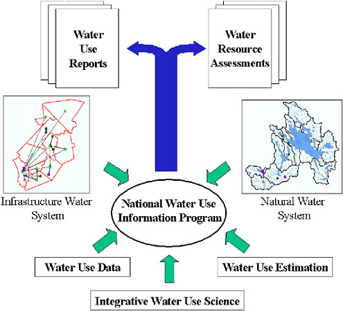
FIGURE ES.1 Conceptual framework for the National Water-Use Information Program.
Note: The vignettes of the infrastructure and natural water systems shown here are drawn from a region in central New Hampshire using data from the USGS New England Water Use Database System.
temporal patterns of water use. It also includes scientifically assessing the impacts of water use on aquatic ecosystems, on the hydrologic cycle, and on the sustainability and vulnerability of the nation’s water resources.
Within the committee’s framework, the NWUIP would have two broad types of products: water use reports and water resource assessments. Water use reports (such as the five-year national summaries) include descriptive data compilations and summaries and status and trends information at the state and regional levels. Water resource assessments characterize the impacts of water use on the reliability and sustainability of groundwater and surface water resources and their associated aquatic and riparian ecosystems.
A GREATER EMPHASIS ON SCIENCE
The NWUIP appears to be viewed as a water use accounting program by many in the USGS Water Resources Division. Because of the significant differences in water use data collection procedures and in data quality from state to state, water use accounting alone cannot provide the estimates of water use that are needed by the nation. The committee found a compelling national need for unbiased science-based water use information. Long-term planning and management decisions need water use information that shows that water is an essential economic commodity and a vital natural resource. Investigations of the reliability and sustainable use of the nation’s water resources require a fundamental understanding of the role of water use in the hydrologic cycle. The NWUIP should therefore be viewed as much more than a data collection and database management program.
The scientific understanding of water use will be most effectively achieved by making water use science the focus of the NWUIP. Water use science refers to the hypothesis-driven investigation of the behavior and phenomena that determine spatial and temporal patterns of water use. This science will directly contribute to the development of techniques that improve water use estimation. Water use science also includes scientific assessment of the sustainability of water resources and the impact of water use on aquatic ecosystems, on the hydrologic cycle, and on the reliability and vulnerability of the nation’s water resources.
Recommendation: The NWUIP should be elevated to a water use science program, emphasizing applied research and techniques development in the statistical estimation of water use and the determinants and impacts of water-using behaviors.
WATER USE DATA
Water use data are collected throughout the nation to support the operation of water supply utilities and water districts. The types of data collected for other water uses vary significantly from state to state.
More than 20 states maintain comprehensive site-specific water use databases, most commonly developed to support regulatory programs that register or permit water withdrawals. In many cases these data are developed through cooperative projects between state water agencies and the USGS. In the remaining states, data are collected only for a subset of water use categories or areas within the states. Some states have no state-level programs for water use data collection. Water use data are more widely collected for surface water than for groundwater, and in some states (e.g., Arizona, Texas, Idaho, and New York), groundwater use data collection is focused on critical groundwater management areas.
There are several reliable national datasets with consistent information that can be used to identify and characterize water withdrawals. At the state level, information exists for more extensive regulatory functions than those conducted nationally, such as permit records for well drilling, water use appropriation, and the management and adjudication of water rights. Thus, even though water use data vary greatly from state to state, a great deal of information is available on water withdrawals in all states. The systematic synthesis and integration of these datasets is a key opportunity for the NWUIP.
The coupling of geographic information system (GIS) technology with these relevant databases is another major new opportunity for the NWUIP. Now, the NWUIP’s only national compilation of water use information is aggregated water use data for counties, states, hydrologic basins, or aquifers. A national synthesis and integration of water use datasets is increasingly feasible, including data on the location and characteristics of water withdrawal sites and, where available, the amount of water withdrawn at the site. Statistical methods for rigorous sampling and estimation of water use for counties, states, hydrologic basins, and aquifers could be devised from such datasets. State and national datasets for water withdrawal by power plants, wells, and water treatment facilities are increasingly available. Other national datasets, such as county-level economic and employment data routinely compiled by the Bureau of Economic Analysis by SIC code, have consistent, national, aggregate information relevant to estimating water use. The synthesis of these datasets is increasingly feasible and is a timely opportunity for the NWUIP.
Recommendation: To better support water use science, the USGS should build on existing data collection efforts to systematically integrate datasets, including those maintained by other federal and state agencies, into datasets already maintained by the NWUIP.
WATER USE ESTIMATION
In practice, estimates of total water use for counties, states, watersheds, and aquifers are based on a combination of available data and surveys, supplemented by indirect estimation methods where survey data are unavailable. Consequently, the accuracy of the data summarized in the national water use reports varies both by state and water use category. The accuracy and confidence limits of these water use estimates are presently not quantified. Statistical methods can support more rigorous water use estimation. Such methods were explored by the committee in two illustrative examples for Arkansas data—stratified random sampling (SRS) and multiple regression analysis.
Using a high-quality, site-specific dataset containing every permitted withdrawal for the state of Arkansas, SRS with a well-constructed rigorous sample
design was used to estimate total permitted withdrawals in the state. This example illustrates how SRS can optimally allocate limited sampling resources among homogeneous subpopulations, or “strata,” of a well-defined statistical population. The number of samples selected from a given stratum is determined by the mean and variance of water use, the number of water use sites in the stratum, and the desired estimation accuracy. In the example presented in this report, water use categories (e.g., public water supply, irrigated agriculture) are used as strata. With additional population information, sample designs could incorporate other attributes such as geographic descriptors, climatic characteristics, or political subpopulations such as counties.
The committee’s investigation of this Arkansas dataset showed SRS can produce reasonably accurate direct estimates of permitted withdrawals, and these results suggest that a rigorous comprehensive evaluation of the use of statistical sampling and estimation methods in the NWUIP may have value. Other states that similarly maintain comprehensive water use databases provide natural experimental settings for the systematic evaluation of these methods. As with all stratified random sample designs, the reduced sampling effort must be accompanied by the additional effort required to maintain current, accurate information about the underlying statistical population being sampled.
The committee also analyzed the structure of the 1980–1995 state-level data from the NWUIP by multiple regression analysis in order to determine if aggregate water use could be correlated with routinely collected demographic, economic, and climatic data. Indeed, a large number of potential explanatory variables for water withdrawal were identified. Potential explanatory variables include water price and gross state product for public water supply withdrawals and the existence of “closed-loop” systems (i.e., cooling towers) for thermoelectric withdrawals. Significantly, the analysis also found discernable responses to climate anomalies (such as droughts and heat waves) in aggregate state-level data; this suggests it is feasible to develop statistical techniques to normalize water use estimates for climate anomalies.
This analysis suggests how statistical methods may yield rigorous estimates and quantitative confidence limits for aggregate water use. Where cost-effective, water use estimates should be based on a complete inventory of significant water use sites in a region. In practice, water use estimates compiled for each water use category and for each county in the nation will consist of a combination of direct observation, random sampling, modeling, and statistical estimation. This mixture of water use estimation techniques requires a framework that best combines data from direct inventories with estimates from statistical sampling and modeling.
Recommendation: The USGS should systematically compare water use estimation methods to identify the techniques best suited to the requirements and limitations of the NWUIP. One goal of this comparison should be to determine the standard error for every water use estimate.
INTEGRATIVE WATER USE SCIENCE
The growth and development of water use science as a cornerstone of the NWUIP inevitably leads to a scientific synthesis, integrating water use with water resources. Integration of several different kinds can be done, including the following:
-
integrating water use with water flow and water quality to develop a total picture of water moving through the landscape,
-
integrating ecological uses of water within streams and aquifers as a component of water use, and
-
integrating water use with those factors that influence it, including economic behavior.
The integration of water use and water resources envisioned here will require more data than just the location and quantity of water withdrawals. Integrative water use science will require a more complete data paradigm, capable of tracking the sources and fate of water use, including consumptive use, as it flows between the infrastructure and natural water systems. The New England Water-Use Database System, used by the USGS in New Hampshire and Vermont, is one useful approach. This is “a link-node” representation of the movement of water from points of withdrawal, through the infrastructure water system, to points of water discharge back to the natural water system. This approach to water use data collection, which is more comprehensive and integrated than that used in most other states, creates the data structures and framework needed to track changes in both water quantity and quality as water moves through the landscape.
The intimate linkage between water quality and water quantity creates both opportunity and need for better connections and integration among the NWUIP, the National Water-Quality Assessment (NAWQA) Program, and the Biological Resources Division (BRD) of the USGS. Water requirements for ecological uses of instream water compete with water withdrawals from streams for other uses. In integrative water use science, both withdrawal uses and instream uses are logically parts of the total water use, within which the effects of human water uses on ecological resources can be studied. The linkage of the infrastructure of water use with the natural water system offers a robust framework from which to understand the impacts of water use on water quality, aquatic ecosystems, the hydrologic cycle, and the reliability and vulnerability of the nation’s water resources.
Recommendation: The USGS should focus on the scientific integration of water use, water flow, and water quality in order to expand knowledge and generate policy-relevant information about human impacts on both water and ecological resources.
FUNDING OF THE NWUIP
A significant limitation of the NWUIP has been its dependence on funding from the Coop Program. The quality and consistency of the NWUIP is uneven, reflecting the interests and cost-shared contributions of each state. Water flows through river basins and aquifers without regard to state boundaries. The national need to assure water supply and to protect water quality and ecological resources requires a stronger national focus on water use within the USGS. Implementing the major recommendations of this report will require continuity and dedicated support for NWUIP at the national level, analogous to the nationally funded component of the National Streamflow Information Program and of other USGS programs.
This report envisions a substantial transformation of the NWUIP. The committee does not see the NWUIP as simply a data collection and database management program focused on county-level categorical water use. Rather, the committee finds that a natural role for the NWUIP would be to complement and become actively integrated with the USGS’s other efforts to provide unbiased science-based information about the adequacy and sustainability of the nation’s water resources. Discussions within the USGS have identified the need to seek dedicated funds to support a national component of the NWUIP, and the committee endorses such a request. The synthesis and integration of national datasets will require active interagency liaison and ongoing dedicated staffing. A rigorous research effort focused on the intercomparison of statistical estimation methods is ideally suited to the USGS’s research expertise and the nationwide infrastructure of the NWUIP. The active collaboration of hydrologists, hydrogeologists, biologists, and water-quality specialists is needed if water use is to be thoroughly integrated with the study of water flow, water quality, and ecological resources.
Recommendation: The USGS should seek support from Congress for dedicated funding of a national component of the recommended water use science program to supplement the existing funding in the Coop Program.


