
2
Geography at the USGS
The future of geography at the USGS evolves against the backdrop of the past and present. Tradition is important as a precursor to change, and the present provides a starting point for the future. The review of geography at the USGS presented in this chapter is a primer for those unfamiliar with geography as a science or with the tradition of geography at the Survey. This chapter shows that present efforts to increase the contributions of geography at the Survey are not new; rather they are a return to a previously successful association between geography and the USGS. The chapter concludes with a brief explanation of modern geography in general, followed by a history of the field’s association with the Survey and its personnel. The chapter continues with an overview of present research contributions in geography at the Survey.
MODERN GEOGRAPHY
Geography’s Themes
Geography as an intellectual discipline is concerned with space, place, and location; and the distribution, arrangement, pattern, and flow of people and things in earth systems. One widely used definition is that geography is:
…an integrative discipline that brings together the physical and human dimensions of the world in the study of people, places, and environments. Its subject matter is the Earth’s surface and the processes that shape it, the relationships
between people and environments, and the connections between people and places (Geography Education Standards Project, 1994).
Geography is not defined by subject matter alone. Geography shares an interest in physical earth processes with such disciplines as geology, oceanography, and meteorology, and an interest in human processes with such disciplines as sociology, anthropology, and economics. Geography is more clearly defined by its unique perspective on the world with its emphasis on spatial relevance. For the geographer, location matters most; other disciplines underscore the relevance of subject matter. Geology, for example, is the science of the earth, meteorology the science of the atmosphere, and sociology the science of human behavior and relationships. The definition of geography as a perspective on place is similar to the definition of history as a perspective on the world from the viewpoint of time. More than most disciplines geography views the world as a system with human and physical components operating in a complex set of interactions.
Because geography offers a spatial view of the world, much of the discipline’s scientific effort goes to exploring how spatial processes operate and how spatial frameworks interact with other basic processes, such as those of physics, chemistry, biology, sociology, political science, and economics. Many geographers are scientists in the sense that they conduct their research according to commonly accepted methods of objective hypothesis testing using repeatable observations. However, some geographers investigate spatial interactions or nature-society connections using non-scientific approaches, employing techniques more closely aligned with the humanities. Because the objects of its study do not strictly define the discipline, natural scientists, social scientists, and humanists may hold the title of “geographer.” The emphasis on spatial considerations has given rise to a particular set of tools and techniques for geographic inquiry, including cartography, remote sensing, and especially GIScience.
All phenomena exist in time and space. Therefore, they have a history and a geography. Consequently, the discipline of geography cuts across numerous scientific boundaries and disciplines. Yet, geography has a core and a coherence that stems from well-developed and widely shared approaches (NRC, 1997; Figure 2.1):
-
A perspective that views the world through the lenses of place, space, and scale;
-
Investigations and explanations that use three domains of synthesis: environmental processes, social dynamics, and a combination of the two; and
-
Spatial representation using visual, tactile, verbal, mathematical, digital, and cognitive methods.
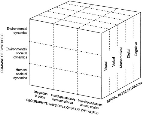
FIGURE 2.1 The matrix of geographic perspectives. Geography’s ways of looking at the world—through its focus on place and scale (horizontal axis)— cuts across its three domains of synthesis: human-societal dynamics, environmental dynamics, and environmental-societal dynamics (vertical axis). Spatial representation, the third dimension of the matrix, underpins and sometimes drives research in other branches of geography. SOURCE: NRC, 1997.
These themes and approaches are important to this report, because they represent shared intellectual perspectives between the field of geography inside and outside the USGS. These concepts are also found in the vision and mission statements of the USGS, providing further connections between the Survey and the more general field of geography.
USGS Influences on U.S. Geography
Except perhaps in the domain of GIScience geography researchers outside the USGS do not interact much with the Survey, but this was not always the case. The central role many USGS geographers played in the early years of most geographic organizations in the United States illustrates the potential for future involvement in the larger sphere of geographic research outside the Survey. These experiences also show that there were strong, though largely forgotten, traditional geographic strengths in the USGS when geographers, geologists, hydrologists, and biologists worked closely with each other in resource surveys in the West (Figure 2.2).
Connections among the USGS, geologists, and geographers developed during the emergence of major professional organizations in the United States. In 1851, in an era of exploration and discovery, the American Geographical Society was formed to provide geographic information to business and government. The basic aim was to facilitate connections between the social world on the one hand and the natural world as represented by geology on the other.
Founded in 1888, the National Geographic Society became the bestknown geographic organization to the U.S. and global public. John Wesley Powell (USGS Director), Henry Gannet (USGS Chief Geographer), and Clarence Dutton (USGS geologist) were all organizing officials of the NGS, and they were instrumental in defining National Geographic Society’s simple but powerful statement of purpose, which still guides the organization: “For the increase and diffusion of geographic knowledge.”
As geology and geography grew into more analytic sciences both fields required scientific societies for the exchange of formal scientific information, rather than the more general venues offered by the American Geographical Society or the National Geographic Society. Both fields were also dissatisfied with the general approach to science by the American Association for the Advancement of Science, where they shared an organizational section (Eckel, 1982). As a result, in 1888 a council of founding geologists, including Powell, established the Geological Society of America. At that time there were about 200 “geologists” in the country. The Association of American Geographers was founded in 1904 by geologic and geographic researchers who were also dissatisfied with the general approaches of other organizations.
USGS geologists played critical roles in the formation and continuation of the Association of American Geographers (James and Martin, 1978). The mainspring of the organization was its first president, William Morris Davis, who was a Harvard geologist adopting a more geographic perspective as his career evolved. Initially, its membership included numerous geologists, seven of whom served as president of the organization: Nevin M.Fenneman,
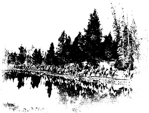
FIGURE 2.2 Geographers, geologists, and biologists of the Hayden Survey exploring the Yellowstone area of Wyoming in 1871. They exemplify the collaborative work among specialists in the western surveys that eventually were combined to form the U.S. Geological Survey. SOURCE: William Henry Jackson photograph 144, USGS Field Records and Photography Library, Denver.
G.K.Gilbert, Herbert Gregory, Francois E.Matthes, W.J.McGee, Rollin D.Salisbury, and Ralph S.Tarr. Although modern geographers might not recognize these names from the scientific literature, geologists would readily remember them as pioneering geologists, most with strong connections to the USGS. For the first several decades of its existence the Association saw geography primarily as the study of Earth as the home of humankind. Now in the early twenty-first century the vision and mission statements of the USGS place a similar emphasis on the perspective of the Survey. For geographers familiar with the Association, this “new direction” appears to be old (albeit valuable) wine in new bottles.
Throughout the middle decades of the twentieth century geology consistently progressed as a science, whereas geography continued its emphasis on description. By the 1950s geology had become an essentially quantitative science. At the same time, geographers had departed from the inclusion of the natural world in the systems they considered. Although regional descriptions inevitably began with the land, water, climate, and vegetation of a given region, there were few physical geographers who investigated these components of the earth system, and the division between geology and geography had become nearly complete. The USGS saw geographers as mappers—cartographers who created topographic maps—who provided little input into the scientific analysis of earth and hydrologic processes.
Beginning in the 1950s, however, the quantitative scientific revolution finally came to the fore in geography. Because the pool of physical geographers had decreased, this revolution most strongly affected the geographic investigators of social and economic phenomena, and the change was generally not visible to geologists. There were some exceptions: spatial analysis techniques were shared between physical and social researchers, but this was not widespread. In the ensuing decades the number of physical geographers increased, especially those engaged in geomorphology, climatology, and biogeography, and they adopted the scientific quantitative approaches now common to their areas of inquiry. At the beginning of the twenty-first century the geographer’s research can be indistinguishable from that of geologists, meteorologists, and ecologists; the determining factor is the emphasis placed on the spatial component of explanation (the portion related to space, and location) or the nature-society connection. Researchers from the other disciplines often emphasize the aspatial aspects of processes, that is, the chemical, physical, or biological dimensions without respect to location. Geographers as a group are also more likely to include human activities in their explanations of natural processes than are researchers from other disciplines.
In the last two decades of the twentieth century an additional boost to geography came from the proliferation of GIS. GIS (remote sensing and mapping) and GIScience (GIS combined with spatial analysis) offered new and efficient ways to display and analyze geographic data. These powerful systems soon found their way into other fields as well, particularly geology, ecology, and climatology in the natural sciences, along with social and economic investigations. Resource analysts and planners began to use GIS to deal with urban, regional, and transportation problems, which further diffused geographic thinking, spatial perspectives, and an interest in nature-society connections by a variety of workers who had not previously dealt with geography. The USGS has become a strong player in the management and generation of the data used by such systems.
In summary the story of geography outside the USGS is significant because geography and the Survey were closely aligned but eventually drifted apart. As the USGS reunites geography with geology, hydrology, and biology in terms of research, instead of description alone, the Survey returns full circle to a previously productive arrangement.
HISTORY OF GEOGRAPHY AND GEOGRAPHERS AT THE USGS
Geography has not been highly visible at the USGS for more than 75 years. Consequently the rich history of cooperation and productivity enjoyed in the close association of geography with the other disciplines at the Survey early in its history is apt to be largely unknown to members of the Survey as well as academicians and professional geographers outside the Survey. A review of the story of geography in the Survey not only demonstrates the opportunities offered by a strong geographic component but also illustrates the ways geography can contribute to ensuring the social relevance of USGS programs.
The USGS originally was formed from four geographic and geologic surveys working in the regions of the U.S. West: the southwest; the interior basin and range, and Colorado plateau; the northwest; and along the fortieth parallel. After the Civil War these independent and distinct surveys began to inventory natural resources and to map publicly owned portions of the then largely unpopulated west. These regions comprised a natural resource base that would fuel the nation’s economic development. Congress defined the survey areas and funded efforts directed by George Wheeler in the southwest, John Wesley Powell in the interior basin and range and Colorado plateau, Ferdinand Hayden in the northwest, and Clarence King along the fortieth parallel. In 1879 Congress ended competition for funding and influence among these individual surveys by combining them into the U.S. Geological Survey, under the direction of Clarence King. A year later John Wesley Powell became the director, and the USGS solidified into an entity that used both geology and geography as tools for the examination, classification, and assessment of the natural resources of public lands.
Geographic description in the form of topographic mapping was the focus of much of the USGS’s early work (Figure 2.3). Because of the need for accurate locational data and exacting representations of the form of the land, topographic mapping was a prerequisite for geologic investigations. Topographic mapping was also the foundation for the Survey’s hydrologic work, as knowledge about the patterns of the nation’s watercourses was a necessary precursor to a useful stream-gaging program. (“Gaging” is the
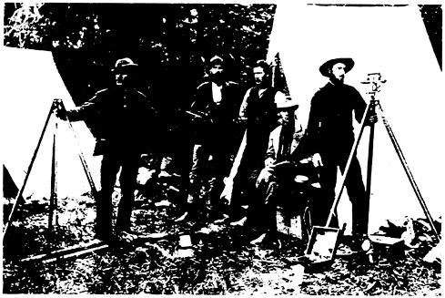
FIGURE 2.3 Geography in the early USGS consisted of the creation of base maps for topography, hydrography, and geology, all founded on field surveys. This group of USGS topographic surveyors posed with their equipment during the survey of western public lands in the 1880s. SOURCE: USGS Field Records and Photography Library, Denver.
technical term used by hydrologists for “gauging” or measuring stream flow). The Survey’s funding request for 1889 is an example of the distribution of annual funding during the USGS’s first two decades. The request demonstrates geography’s strong role by including about $200,000 for topographic surveys, $100,000 for geologic surveys, and about $100,000 for all other expenses combined (Rabbitt, 1980).
The importance of the early USGS’s geographic or topographic work led to the creation of the position of Chief Geographer. Henry Gannett was appointed the first Chief Geographer in 1882, and he remained with the Survey in various geography-related positions until his death in 1914. Gannett’s first task was the creation of a national topographic map that would serve a variety of purposes, including as the base of the national geologic map. He hired 78 cartographers and topographers (geographers), and geographers outnumbered geologists for nearly two decades (Rabbitt, 1980). In addition to his USGS work Gannett chaired the U.S. Board on
Geographic Names, was the Chief Geographer for the tenth, eleventh, and twelfth U.S. Censuses, and worked as assistant director and statistician for a census of the Philippines.
During the early years of the USGS, the difference between geographer and geologist was indistinct, and many practitioners considered themselves to be both. With a perspective that has re-emerged in recent vision and mission statements of the USGS, John Wesley Powell often styled his own career as one of geology and geography, because of his consuming interest in what would later be called the nature-society interface (Stegner, 1954). In addition he saw the early role of the USGS to include hydrologic hazard prediction, which he emphasized after the Johnstown flood of 1889. Powell’s most trusted associate, Grove Karl Gilbert, who held the position of Chief Geologist, also followed the dual model of geographer and geologist (Pyne, 1980). He projected the USGS into the disciplines of geography and geology outside the Survey. Today Gilbert is largely thought of as a geologist, yet he characterized himself as a geographer as well, and he was active in geography organizations. He was the only person to serve as president of both the Association of American Geographers and the Geological Society of America. The degree of his influence is now apparent; both societies recognize research excellence with “G.K.Gilbert Awards.”
After about 1900 geography declined at the USGS. Powell had resigned as director in 1894, and Gilbert stayed with the USGS until his death in 1918. Gannett remained active, but he worked as much outside the Survey as he did inside. The USGS had changed its emphasis, focusing more on scientific research on geologic and hydrologic processes. By 1930 topographic maps (at a scale of 1:250,000) were available for most of the nation (Thompson, 1981), and attention along with an increasing percentage of the Survey’s budget turned to using the maps as bases for geologic and hydrologic work (Figure 2.4). Although there was continued emphasis on stream gaging for water resource development and the geologic work that led to the development of minerals and fuels, there was a gradual shift away from other issues that were specifically related to societal concerns. During the first half of the twentieth century geology and hydrology grew into sophisticated sciences defined by their subject matter, while geography in the survey dwindled to descriptive cartographic work. Although mapping continued between 1920 and 1960, geographic research generally disappeared from the Survey.
By the early 1960s the moribund state of geography at the USGS began to change. In many respects during the previous several decades geography at the USGS reflected the reduced effectiveness of geography outside the survey. At the time academic geography began to progress rapidly into its scientific era, significant changes were occurring at the USGS. Owing to a
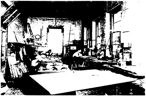
FIGURE 2.4 Creation of topographic maps in the early USGS required geographic technicians and much direct hand labor, as shown in this view of USGS map production facilities at the end of the nineteenth century. SOURCE: USGS Field Records and Photography Library, Denver, Colorado.
variety of new demands the discipline slowly began to return to visibility (Witmer, 2000). First, the U.S. Board on Geographic Names, which for several decades had been independent under the DOI, returned to the jurisdiction of the USGS. Second, the Survey began planning for the first national atlas, a project requiring a vast range of expertise and geographic integration. Third, researchers at the USGS became interested in remote sensing and in the quantitative spatial analysis used to exploit remotely sensed imagery from satellites (then a new technology). Fourth, the USGS made increasing use of classified geographic data that was created by senior geographers as part of their intelligence work during World War II. Fifth, demand increased from the Survey’s clients and partners for remotely sensed geographic data on land use and land cover for mapping. Finally, the entire national perspective on natural sciences began to focus on environmental systems rather than on individual resource components. Geography theory and application were ready.
A reflection of this resurgence of geography at the USGS came with a return to the appointment of chief geographers, the first since the nineteenth century. As the second Chief Geographer, Arch Gerlach became the chief of the national atlas project and he directed the fledgling Geographic Applications Program, which was heavily involved in remote-sensing applications. With a much broader base at the USGS than the discipline had previously had, in the late 1960s geography consisted of two components: one largely descriptive and the other based on research and problem solving. In the 1970s James R.Anderson became the third Chief Geographer, and he oversaw a dramatic increase in the use of geography as an instrument for applied problem solving. Under his direction a national land use and land cover assessment program evolved, GIS and remote-sensing systems research flourished, and digital cartography emerged. Anderson increased the number of geographers working at the USGS, although cartographers and remote-sensing technicians dominated most of the new positions.
Anderson improved geography’s ties between the Survey and the outside community. He was active with those in private industry and supported their emphasis on applied geography, meaning the application of geographic theory and technology to problems of social and economic interest. Anderson was active in the Association of American Geographers, and after his death in 1979 the Association created an “Anderson Medal” to recognize outstanding applied geographers.
Throughout the 1980s and 1990s geography slowly became more prominent at the USGS, although there was no Chief Geographer during much of that time. The Geography Program begun by Gerlach merged with the National Mapping Program and eventually became the National Mapping Division. The division was on an equal organizational footing with divisions for geology, hydrology, and later, biology, but its staff was smaller than the other three divisions. In 1995 the Survey’s fourth Chief Geographer, Richard Witmer, undertook extensive efforts to modernize geography at the Survey, and he took up his predecessor’s efforts to build ties with the geographic community outside the Survey. Links were established with state-based geographic information agencies and with the University Consortium on Geographic Information Science. He used two external studies, one by the National Research Council (NRC, 1997) and one by the National Academy of Public Administration (NAPA, 1998), to support the position that geography could make important, useful contributions to the Survey and the nation.
During this time geography at the USGS was also affected by an increased emphasis on spatial data and mapping requirements. Spatial data have become more common in the Survey and in the federal government overall, a trend that places greater demands on geographic analysis and data
management. Digital mapping became a major effort jointly undertaken by the USGS and the Bureau of the Census, and the USGS became a major player in the new National Spatial Data Infrastructure (NSDI). The NSDI consists of the technologies, policies, and people necessary to promote sharing of geospatial data throughout all levels of government, the private and non-profit sectors, and the academic community. The initial description of the NSDI noted that it was to be the “means to assemble geographic information that describes the arrangement and attributes of features and phenomena on Earth. The infrastructure includes the materials, technology, and people necessary to acquire, process, store, and distribute such information to meet a wide variety of needs,” (NRC, 1993).
In 1994 a presidential order directed that the Federal Geographic Data Committee (FGDC) control the NSDI and be housed in the USGS, with the mission of coordinating spatial data across all federal agencies. The FGDC builds partnerships with federal, state, and local governments to ensure a smooth flow of data in a standardized form that is readily accessible to a variety of users without unnecessary duplication (NRC, 1994). The USGS’s expertise made it a natural leader with the virtual explosion in the use of GIS and remote sensing for the natural and social sciences and in decision making.
Another emerging geographic activity at the Survey is in mapping requirements. Previously most geographers were assigned to the task of completing the topographic mapping of the entire nation at scales of 1:62,500 or 1:24,000, a monumental effort that had begun more than a century before. As a reflection of the changing nature of geographic data, the USGS has also undertaken the task of creating an electronic national atlas, a digital version of the paper version. This national atlas is now available directly on the World Wide Web and provides users flexibility in creating individually tailored maps for specific applications.1
The emergence of spatial data and its analysis, along with increasing emphasis on nature-society relationships, play to two of geography’s most enduring themes. However, as a result of the recent emphasis on cartography and mapping, the Survey cannot respond adequately to these research priorities. The Survey employs geographers in a variety of positions, mostly under job titles other than “geographer.” Geographers at the USGS are mostly cartographers, rather than research scientists.
Personnel trained in geography are essential for developing the geographic information demanded by the Survey’s clients and partners. Without
|
1 |
The National Atlas (http://www.nationalatlas.gov) is a digital update of a large collection of paper maps that delivers easy-to-use map products to the public. It is distinct from The National Map discussed in Chapter 4. |
additional experienced and highly skilled geographers in-house the USGS will be unable to provide comprehensive responses to societal needs. New hiring priorities should be based on the Survey’s long-term core research agenda (NRC, 2001b), which has a significant geography component. The mission to “provide the nation with reliable, impartial information to describe and understand the Earth” (USGS, 1996) is similar to standard definitions of the general interests of geographers. Thus geographers who can provide leadership in the area of spatial analysis and on the integration of nature-society information should be recruited.
PRESENT GEOGRAPHY CONTRIBUTIONS TO THE USGS
Geographic research makes important contributions at the USGS (1) as an avenue of integration among the other disciplines; (2) as a form of research related to geographic data; and (3) in the creation of new tools for geospatial analysis. A summary of each of these roles reveals the present status of geography at the USGS.
Geography as an Integrator
Geographers are integrators of information and ideas from a variety of disciplines. Because of their integrative expertise, geographers often head multidisciplinary teams in attacking specific problems. A major method for bringing together disparate researchers and their activities is data integration, usually through one of three common approaches: historical, general systems, and geographic.
Historical approaches permit the organization of ideas, data, information, and ultimately explanations according to time. The logical arrangements of cause and effect emerge from time-based assessments of events, leading to attempts to predict the future by extending existing trends. Historical approaches can be worked in reverse as well, by observing present forms and processes and projecting them into past situations. Geologists rely on this approach with their motto of “the present is the key to the past,” which has shown to be effective in unraveling Earth history by observing and measuring present processes. Hydrologists also search for historical trends in water resource data in attempts to predict future events.
General systems approaches rely on systems defined by elements and their functional interconnections. Analyses of elements and their connections as well as flows of mass and energy provide insight into the operations of complex systems, which are common in nature and society. In the natural
sciences this is the ecological approach, wherein organisms and their inorganic support elements are viewed as elements and relationships within an operating system. For example, the fate of contaminants in a watershed can be described and understood by constructing a set of boxes (which represent the elements or compartments of the system) connected by arrows showing the rates of flow between them. The elements and flows can be quantified, with the objective of predicting the contaminant contents of each compartment.
Geography integrates data and information according to location, and it uses the map as the basic tool of representation. In a geographic approach to integration and synthesis each element and flow has geographic characteristics of location, place, arrangement, and direction of movement. The geographic perspective provides a significant tool for integrating data from a variety of sources and thus provides a common language for cooperation.
Geographic Data and Research
Geographic or location-specific data lie at the heart of much of the research conducted by the USGS. In science, description of phenomena is the starting point of the scientific method that ultimately results in explanation. Sciences mature as they graduate from an initial period consumed by description and classification into a period of more sophisticated hypothesis testing and analysis, followed by synthesis and theory building. For example, the science of ecology began with a period of “natural history.” In this phase the classification of plant and animal species into elaborate descriptive systems occupied the time of most researchers. Later the science used those descriptions as a basis for insightful investigations of the environmental interactions of organisms and species. Geology followed a similar route, with early field descriptions of rocks being used to build spatial and temporal classification systems. By the late 1800s geology had become oriented more toward explanations that were scientific in nature.
Geography has gone through a similar evolution of scientific activity, but its embrace of scientific methods in the United States was much later than in other fields, such as ecology and geology. Topographic mapping in the 1800s was the geographic correlative to biologic and geologic description. Regional classifications were the geographic counterparts of the orders and families of species in biology or the terrains and eras in geology. Biology and geology progressed to quantitative scientific analysis at the turn of the twentieth century, whereas geography began that transition in the 1960s.
Geographic science is concerned with how geographic processes operate and how geographic patterns or frameworks influence human and natural phenomena. Examples of geographic science at work include: the spatial mechanics of diffusion; the influence of location and distance on the connections between entities; the topology of networks and regions; and how that topology influences physical, chemical, biological, and social processes. In nature-society interactions geography offers insights into hazards and resource perception as well as explanations for social outcomes of natural processes.
The result of the late emergence of geographic science is that many people outside the discipline are unaware of the recent advances in geographic theory and analysis. They continue to equate geography with pure description. If the USGS persists in viewing the potential contributions of geography and geographers as being solely in the areas of describing landscapes, stream networks, drainage basins, or hazards regions, the Survey will not benefit from the discipline’s progress. Given that geography’s basic proposition, that space, place, location, and the interaction between nature and society are keys to explanation, limiting the discipline to description will unnecessarily limit the Survey. In order to capitalize on the scientific advances the discipline has made outside of the Survey since 1960, the USGS will have to adopt new geographic research priorities to augment its descriptive capabilities in geography.
Geographic Techniques
When sciences emerge from their descriptive phases into activities more directly related to analysis, synthesis, and explanation, they often develop new tools and methods for measurement, display, and analysis. In the last 20 years geography has developed methods and tools of such utility and sophistication that they are widely used by the other natural and social sciences. The primary collection of geographic techniques and technology that support the modern revolution in geographic research include surveying, cartography, geographic information systems, remote sensing, and spatial statistical analysis. These tools form the basis of a geographic technology that is used in the acquisition, assimilation, manipulation, and representation of spatial data.
Surveyors, cartographers, GIS specialists, and remote-sensing professionals have ongoing concern with the acquisition, assimilation, manipulation, and representation of spatial data. The widespread adoption of digital technology and methods for management of large spatial datasets, has led to developments in all of these areas. Moreover, digital spatial information, which varies
with scale, time, and spectral characteristics (the amount of electromagnetic energy exiting or emitted by an object or geographic area measured from a distance), presents unique theoretical and methodological opportunities for research.
The USGS conducts physical, biological, and social science research within its disciplines (Figure 2.5). Much of this science requires the collection of spatial information using in situ techniques, including personal observation and measurement with calibrated instruments. In addition, spatially distributed information is analyzed using technologies from cartography, surveying, and GISs. Dahlberg and Jensen (1986) suggest a model in which there is three-way interaction among the techniques where no sub-discipline dominates and all are recognized as having unique yet overlapping areas of knowledge and intellectual activity, the way they are used in physical, biological, and social science research (Figure 2.5).
Surveying
Surveying in the field for geologic, hydrologic, and biologic purposes has undergone a substantial revolution in recent decades. Although some traditional surveying is still accomplished using optical survey instruments, sight lines, and physical measurement, the Global Positioning System (GPS) is most commonly used now. With readily available hand-held instruments, this system commonly provides accuracy to within about a meter; increased accuracy is available with some additional instrumentation. The output from these field survey activities includes specific data personally recorded in the field along with precise location identifiers. For example, a researcher sampling vegetation types across a flood plain might use GPS to locate the ends of a 100-meter sample line and then count the number of individuals of a particular species encountered within three meters on either side of the line. Several such sample lines in a variety of nearby locations, each identified by the coordinates of its endpoints and with associated counts, become part of a dataset easily loaded into a GIS for mapping and further processing. All operations from initial sampling and counting to the final mapping and analysis are entirely digital.
Remote Sensing
Remote sensing is “the measurement or acquisition of information of some property of an object or phenomenon by a recording device that is not in physical or intimate contact with the object or phenomenon under study,”
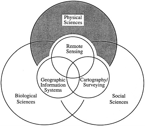
FIGURE 2.5 Venn diagram of physical, biological, and social sciences with remote sensing, GIS, and cartography. SOURCE: Jensen, 2000.
(Colwell, 1983). It is a scientific activity that uses sophisticated sensors to measure the amount of electromagnetic energy exiting an object or geographic area from a distance. These data are then analyzed to extract valuable information using heuristic logic and/or mathematical algorithms (Jensen, 2000). Remote sensing functions in harmony with other spatial data collection techniques or tools of the mapping sciences, including cartography, surveying, and GIScience (Curran, 1987).
The USGS has been involved in the use of remote sensing technology for many of its scientific endeavors since the 1920s. Scientists at the Survey have grasped the significance of remote sensing scientific technology and used it as one of their main methods of obtaining important cultural and biophysical information (Figure 2.6) and have made important contributions to science. Important ongoing USGS projects that involve remote sensing
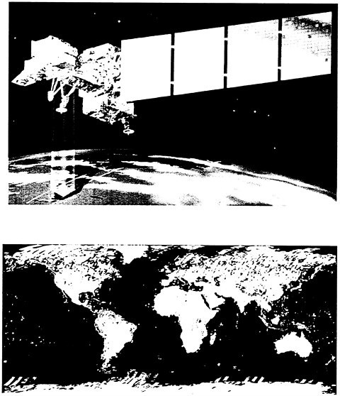
FIGURE 2.6 (a) The Landsat 7 Enhanced Thematic Mapper Plus (ETM+) multispectral remote-sensing system operated by the U.S. Geological Survey’s EROS Data Center in Sioux Falls, South Dakota, (b) A mosaic of primarily cloud-free Landsat ETM+ images for much of Earth’s surface. Individual orbital paths are discernible. SOURCE: USGS EROS Data Center.
include: (1) the development of an ambitious digital product, The National Map; (2) the development of the National Land Cover Dataset; (3) the creation of the global land cover dataset and the global forest map; and (4) major imagery archiving projects such as aerial photography, Landsat satellite data, Space Shuttle radar data, and accurate digital elevation models.
Cartography
Cartography includes the vital geographic functions of information representation and visualization within a spatial context. It underlies much of geographic analysis, and is concerned with all aspects of mapping. These aspects include: (1) the mathematics of projecting and abstracting (generalizing) Earth observations onto a map surface; (2) the cognitive and computational issues of geographic visualization; and (3) the design of algorithms controlling map production and dissemination (including Internet and related technologies). Cartographers also work to develop efficient ways of representing geographic features in digital format (Figure 2.7). They develop algorithms for efficiently storing complex digital spatial data, and for near-real-time data updates. Other USGS cartographic projects include hypermedia and animation methods for displaying patterns that change over time, the electronic National Atlas, and the World Construction Set (Figure 2.8).
GIScience
Geographic information scientists engaged in spatial analysis organize geographic information in a computer database, develop numeric models, and interpret spatial and temporal patterns in archived data (Longley et al., 2001). GIScience deals with the fundamental issues underlying spatial data and information technology. The software packages commonly referred to as GISs incorporate algorithms for the storage, retrieval, and analysis of geographic information. These algorithms are designed to handle large databases containing geographic data that vary in space and time. Spatial algorithms distinguish GISs from other types of information systems such as those that handle credit card transactions, personnel records, or other non-spatial applications.
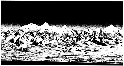
FIGURE 2.7 A three-dimensional perspective of Kamchatka Peninsula, Russia, showing a cartographic representation of digital data. SOURCE: NASA Jet Propulsion Laboratory.

FIGURE 2.8 A digital cartographic image from the World Construction Set, showing diverse patterns over time. SOURCE: Dave Catts, USGS.
Spatial analysts build numeric models integrating biological, geological, hydrological, and social science data to study how location affects physical and human processes. They utilize spatial statistics to assess the reliability and validity of the models they create. For example, assessments of water supplies from alpine areas can use an image that presents a simplified model integrating terrain, rock type, and snow depth to predict availability of drinking water from snowpack in an alpine region (Figure 2.9). In other applications GIScience modelers overlay field data going back several hundred years to predict which vegetative types are most vulnerable to recurring severe forest fires. In a large-scale application the Gap Analysis Program (GAP) interrogates national datasets to determine and eliminate gaps in public lands and national parks so that habitats for endangered species can be preserved. GIScience in all its applications focuses on dependencies across space (spatial autocorrelation) and the influence of spatially distributed causal factors (spatial regression).
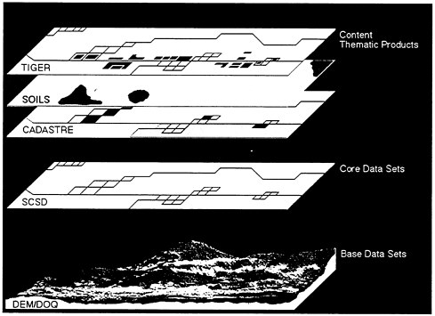
FIGURE 2.9 Digital data layers showing alpine terrain, hydrology, and vegetation, Niwot Ridge, Colorado. SOURCE: Larry Ayers, Intergraph Corp.
SUMMARY
Through much of the twentieth century geography at the USGS came to be synonymous with and virtually limited to mapping. Now the Survey faces challenges that result from three kinds of fundamental change. First, print maps have become much less important as end products for USGS while new digital products are increasingly important, resulting in a demand for an entirely new approach. Second, geography has changed as an academic discipline outside the Survey. Offering new perspectives on geography could contribute to the mission of the USGS. Third, the roles of the USGS have become more rich and complicated, as well as more strongly directed toward processes at the Earth’s surface, necessitating a reassessment of priorities for the Geography Discipline.
From an operational standpoint geography is an integral part of the USGS’s past and its present. During the early years of the Survey geologists and hydrologists worked closely with geographers. After a period of relatively little geographic activity at the Survey, geography is again a significant component of USGS activities. With the identification of the Geography Discipline at the USGS as an institutional partner with the Geology Discipline, Water Discipline, and Biology Discipline, geographic contributions in the future will likely be much more prominent. Selection of geographic research priorities will define the nature of geography’s involvement in the reformed Survey. The following chapters explore these priorities in three general groupings: geographic data management, GIScience, and land surface-society interactions.


