
3
Facing the Earthquake Threat
Earthquakes rival all other natural disasters inthethreat they pose to human life and habitat. Unlike floods, hurricanes, and volcanic eruptions, specific earthquakes cannot be predicted with the short-term accuracy required for effective emergency management. The science is now capable of identifying where earthquakes will happen and how big they might be, but such forecasts are valid only for intervals measured in decades or even centuries. Once an event has occurred, there is very little time for warning and action; the fast-moving seismic ground waves do most of their damage in a macroseismic zone within the first minute or so after the rupture nucleates (1). Preparation and rapid emergency response are therefore the bulwarks of a good seismic defense. This chapter describes the context of current efforts to improve seismic safety and performance by summarizing what is known about the principal types of earthquake hazards, their distribution across the nation and the world, and the knowledge-based approaches to reducing earthquake risk. It concludes by addressing the issue of how scientists can help to implement the knowledge gained through research by stimulating civic actions that actually reduce risk.
3.1 TYPES OF SEISMIC HAZARDS
Earthquakes pose several types of threats that often proceed as chain reactions. The primary hazards are the breaks in the ground surface caused when faults rupture, the seismic shaking radiated from the fault slip dur-
ing rupture, and the permanent subsidence and uplift. Strong ground motion may, in turn, cause ground failure—slumps, landslides, liquefaction, and lateral spread—depending on shaking intensity (usually stronger nearer the source) and local site conditions. If it occurs offshore, fault displacement can generate tsunamis capable of inundating nearby and distant shorelines. Ground failure and tsunamis are examples of secondary hazards (2).
Fault Rupture
Tectonic earthquakes are spontaneous releases of tectonic stress that produce macroscopic, permanent displacements across fault surfaces (ruptures) and within the rock mass around faults (co-seismic deformations). Most fault ruptures are confined to buried regions of the crust where brittle behavior allows stick-slip instabilities to nucleate (e.g., between 2 and 20 kilometers deep in most continental deformation zones). Such ruptures propagate to the surface only in larger earthquakes. When this happens, however, almost any structure built across the rupture path will be deformed by the severe strains characteristic of primary ground failure (Figure 3.1). Predicting the magnitude and extent of fault rupture is therefore a major issue in seismic hazard analysis.
Ruptures tend to occur along faults that have produced large earthquakes in the past, so a map of active faults is a first-order representation of the rupture hazard. The average amount of co-seismic slip increases systematically with earthquake magnitude (3), and the maximum displacement tends to occur toward the middle of the rupturing segment. These behaviors can be used to quantify the hazard along well-defined active faults. For example, where the Hollywood subway crosses the Hollywood fault in Los Angeles, California, the maximum expected slip is estimated to be 1 to 2 meters. In anticipation, the Metropolitan Transportation Authority overbored the subway tunnel to allow the tracks to be realigned after such an earthquake.
Mapped faults are often categorized as active and inactive, but doing so is problematic because the maximum magnitude, frequency of rupture, and other measures of activity can be highly variable among faults in the same tectonic province. Even within a single zone, the distribution of recent faulting can be considerably more complex than the simple traces that represent active faults on small-scale geologic maps. Detailed mapping reveals a wide range of features, such as segmentation, stepovers, and faulting at conjugate angles, often with self-similar scaling (Figure 3.2). The faulting patterns observed in large earthquakes show similar complexity, which can vary rapidly along strike. In some places, the rupture may be a single, clean break, while elsewhere it may occupy a zone tens or hundreds
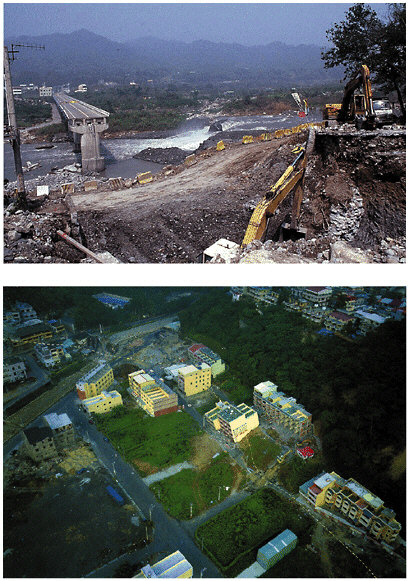
FIGURE 3.1 Damage due to fault rupture during the September 20, 1999, Chi-Chi, Taiwan, earthquake (magnitude [M] 7.6) was extensive along the Chelungpu fault. Structures that were built to withstand strong ground motion nevertheless did not survive severe dislocations along the fault. The left abutment of this bridge across the Ta-An River was constructed through the fault plane (top). The thrust fault slipped about 10 meters during the earthquake, severely deforming the pillar and, thus, destroying the bridge. After the earthquake, the abutment was reconstructed in the same location. Most reinforced multistory concrete structures survived the shaking, but those on the fault trace collapsed or suffered severe tilts and other distortions, which rendered them uninhabitable (bottom). SOURCE: Photographs courtesy of Kerry Sieh, Caltech.
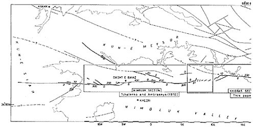
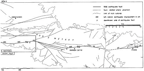
FIGURE 3.2 Map of the surface trace of the 1968 Dasht-e-Bayez, Iran, earthquake rupture (M 7.3). SOURCE: J.S. Tchalenko and M. Berberian, Dasht-e-Bayez fault, Iran: Earthquake and earlier related structures, Geol. Soc. Am. Bull., 86, 703-709, 1975.
of meters wide comprising en echelon offsets, anastomosing fractures, mole tracks, nonbrittle warping, and other types of co-seismic deformation (4). A more complete characterization of the rupture hazard will require a better understanding of how the distribution of surface breaks depends on the details of the fault slip at depth and how fault movements interact with a variety of structural factors, including topography, near-surface sedimentary layering, and fault-zone complexity.
Ground Shaking
Ground shaking is typically the primary cause of earthquake damage to the built environment. Shaking occurs during the passage of seismic waves as they propagate away from the rupturing fault. The most destructive shaking is usually the horizontal ground motion from S waves and surface waves, although the vertical component of motion can also excite a damaging structural response. The severity of the shaking is typically measured by the peak ground acceleration (PGA) or peak ground velocity (PGV), as recorded on strong-motion seismographs in the free field (i.e., on open ground away from buildings or other structures), or by the spectral response of a standard oscillator, either spectral acceleration Sa or spectral velocity Sv, calculated from the observed “time history” of
the shaking (5). Measurements by strong-motion instruments near large earthquakes have shown that the time histories can be complex and can vary rapidly from place to place, especially at high frequency where interference effects are typically strong.
Seismic waves are generated by fault slip during an earthquake. The distribution of the slip in space and time determines the radiation pattern (i.e., how the wave amplitudes vary with direction away from the fault). Small earthquakes can usually be approximated by the beachball-looking radiation patterns described in Section 2.3, but larger events show significant complications and asymmetries. For instance, the propagation of a rupture along a fault may produce a directivity pulse of coherent, high-amplitude shear motion at locations in the propagation direction. Rupture directivity effects, amplified by basin-edge effects, were the primary cause of the damage in the 1995 Hyogo-ken Nanbu earthquake. During the 1994 Northridge earthquake, the ground motion at frequencies below 2 hertz was observed to be highest at locations around the top edge of the fault to the north of the hypocenter, consistent with the directivity pulse expected from the Northridge rupture. At higher frequency, the radiation of waves from fault surfaces becomes less coherent, owing to small-scale fluctuations in fault slip and nearby material irregularities, causing the rupture directivity effect to become subdued and other effects such as
proximity to the fault to dominate. In the Northridge earthquake, ground-motion amplitude greater than 2 hertz was observed to be highest above the hypocenter on the hanging wall side (6), not around the top edge of the fault, which experienced the longer-period directivity effects. Systematic differences in ground motion have been observed for different faulting types (7), but as yet no clear explanation of this exists. Elucidating how faults radiate seismic energy across the entire frequency band relevant to earthquake engineering (0.1-10 hertz) is a research challenge of major importance.
The amplitude of seismic waves generally decreases as the waves propagate away from the source (as required to conserve energy), but the measurement from large earthquakes always exhibits a high degree of scatter. In seismic hazard analysis, the decay of ground-motion intensity with distance is represented by an attenuation relation, usually derived by fitting smooth functions to the scattered data (see Section 2.7). An objective of current research is to explain the variations in shaking intensity through a more fundamental understanding of the wave propagation process (8). Important physical effects include refraction by variation in the seismic velocity, reflection from surfaces of material discontinuity, and damping by the anelastic response of the rock and soil media. Some of the strongest variations are associated with horizontal layering of the crust and upper mantle. In the 1989 Loma Prieta earthquake, shear waves, critically refracted from the M discontinuity at the base of the crust (SmS waves), were partially responsible for the shaking that damaged parts of San Francisco nearly 90 kilometers from the epicenter (9). Data from aftershocks of the 1994 Northridge earthquake demonstrated that reflections from midcrustal interfaces can increase the shaking from shallow sources at certain shorter distances.
Seismic waves can be amplified or attenuated by three-dimensional structures such as fault-bounded blocks and sedimentary basins. Earthquakes can excite resonance in the deep basins, shaking the soft sediments like jelly. A striking example was the massive destruction and loss of life during the 1985 Michoacan earthquake (moment magnitude [M] 8.0) in the parts of Mexico City underlain by soft, lake-bed clays. The source was in a subduction zone more than 350 kilometers away, which under normal circumstances would have caused little damage; however, sediment resonance was observed to amplify the spectral acceleration at low frequencies (about 0.5 hertz) by factors as large as 8 to 50 times relative to hard-rock sites (10). Other mechanisms for amplification include the focusing of waves by lens-like structures (11) and the generation of surface waves by the fault-bounded edges of sedimentary basins. Basin-edge effects of the latter type were partly responsible for the extreme damage to the Japanese city of Kobe in the 1995 earthquake (Box 2.4).
The response of soils at shallow depth to strong shaking is a complex phenomenon (12). Amplitude builds as the waves slow (another consequence of energy conservation), so seismic shaking is typically amplified in the soft soils and unconsolidated sediments near the ground surface, where the wave speed can be much lower than in hard rock. For this reason, the average shear velocity in the upper 30 meters or so has become the primary basis for the National Earthquake Hazard Reduction Program (NEHRP) site classification used in many building codes, including the 1997 Uniform Building Code (UBC), 2000 International Building Code (IBC), and 2000 American Society of Civil Engineers (ASCE) Standards 7-98 (13). The high amplitude predicted by the linear wave theory is thought to be reduced by the nonlinear response of the unsaturated near-surface layers. Laboratory tests clearly demonstrate nonlinear strain behavior in soils under dynamic loading, but the importance of nonlinearity during actual earthquakes continues to be debated. Using available ground-motion data to differentiate nonlinear strain behavior from other wave propagation effects has usually been difficult. For example, interpretations of the data collected in Mexico City from the 1985 Michoacan earthquake reached conflicting conclusions on the importance of the nonlinearity of the city’s soft clay deposits (14). On the other hand, direct evidence of significant nonlinear soil response was clearly observed in the motions recorded by surface and subsurface (borehole) instruments at saturated sandy sites that liquefied during the 1987 Superstition Hills, California, and the 1995 Hyogo-ken Nanbu earthquakes (15). Aside from these extreme cases where the soil failed, indirect evidence of nonlinear site response on soils that remained stable during strong shaking is becoming more apparent with the greater number of seismograms being recorded in strong-motion arrays throughout the world (16). However, more of these data are clearly needed to better understand and predict this phenomenon.
Another interesting aspect of seismic shaking is that it can vary substantially from one tectonic setting to another. For example, the motion from similar-sized earthquakes is observed to be stronger in the central and eastern United States than west of the Rocky Mountains. Felt areas and areas of specific intensity (isoseismals) are also larger for earthquakes in the central and eastern United States compared to those of earthquakes with similar magnitudes in the western United States. Earthquakes in the older, stronger regions of the continent generally have greater stress drops and therefore radiate more high-frequency energy for a given amount of fault slip; moreover, their seismic waves propagate with less attenuation compared to earthquakes in plate boundary deformation zones. The attenuation difference is probably attributable to lower temperature, reduced scattering, and more continuous waveguide for crustal shear en-
ergy (Lg waves) in the more stable crust of the central and eastern United States. Regional studies that deploy seismometers more densely will be needed to clarify these explanations and to understand how the vertical and lateral structure of the crust controls ground motions.
Subsidence and Uplift
Large thrust earthquakes in subduction zones can cause sudden, permanent elevation changes with damaging effects to coastal areas. Uplift and subsidence related to fault slippage on shallow thrusts have been documented in New Zealand, Japan, Chile, and southeast Alaska (17). During the great 1964 Alaska earthquake (Box 2.3), the shorelines of Prince William Sound rose in some places by several meters, draining small-craft harbors, while they dropped in others, causing the streets of coastal towns to flood at high tide. Submerged marshlands in several estuaries along the coasts of Washington, Oregon, and northern California indicate that similar episodes of sudden subsidence have resulted from large thrust events in the Cascadia subduction zone (described in Section 3.2). The pattern of uplift and subsidence during an earthquake can be predicted from elastic dislocation models if the area of the fault plane and the distribution of slip within that plane are known (18). Anticipating the damage from elevation changes in future events can thus be approached by combining theoretical studies with seismic, paleoseismic, and geodetic observations.
Secondary Ground Failures
The secondary hazards caused by seismic shaking include forms of mass wasting—such as landslides, rockfalls, and slumps—as well as soil failures associated with compaction, liquefaction, and lateral spreading (19). In some instances, these failures cause more damage than the ground shaking itself. An M 8.6 earthquake in China’s Gansu Province in 1920 triggered an extensive debris flow, which covered a region larger than 100 square kilometers and resulted in roughly 200,000 deaths. An immense rock and snow avalanche (60 million cubic meters) triggered by the 1970 Peru earthquake (M 8.0) buried the mountain towns of Yungay and Ranrahirca, killing 66,000 people (Figure 3.3). Many of those killed in the January 13, 2001, El Salvador earthquake were buried by a muddy landslide loosened from a slope in the capital’s suburbs.
Liquefaction is the temporary conversion of water-saturated, unconsolidated soils into a medium that behaves like a fluid. It occurs when saturated sand or silty sand is shaken hard enough to mobilize individual grains. If the water cannot escape the granular soil matrix fast enough to
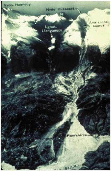
FIGURE 3.3 Destruction of the mountain towns of Yungay and Ranrahirca, Peru, which were buried by an avalanche triggered by the 1970 earthquake (M 8). SOURCE: Photo by Servicio Aerofotografico Nacional de Peru; available from the U.S. Geological Survey, <http://landslides.usgs.gov/>.
permit compaction, more of the overburden load becomes supported by the water, resulting in increased pore pressure. This process can progress relatively quickly to the point at which the pore-water pressure becomes equal to the overburden stress, creating quicksand-like conditions. The liquefaction potential of any particular saturated deposit depends primarily on the age and grain-size distribution of the deposit as well as the ampli-
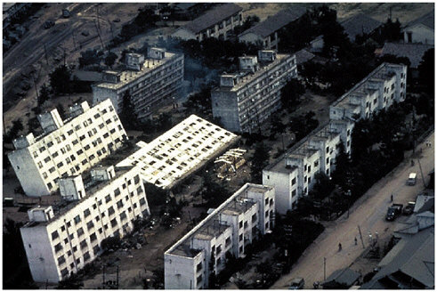
FIGURE 3.4 Tilting of apartment buildings at Kawagishi-Cho, Niigata, Japan, produced by liquefaction of loose, water-saturated sediments caused a loss of load-bearing capacity during the 1964 Niigata earthquake (M 7.5). The losses from this earthquake exceeded $1 billion in 1964 dollars. SOURCE: National Oceanic and Atmospheric Administration, National Geophysical Data Center.
tude and duration of the ground shaking (20). The dangers of liquefaction are thus compounded in deep sedimentary basins, where the water table is often shallow and the shaking amplitude and duration tend to be increased by seismic-wave resonance within the basins. Liquefaction can severely damage foundations and other subsurface structures, causing large buildings to sink or tilt (Figure 3.4) and underground structures, such as pipelines and storage tanks, to float to the surface when they become buoyant in the liquefied soil. If the liquefied layer is close to the surface, it may break through dryer deposits overlying the water table, forming geysers that leave sandblows as postseismic evidence. In fact, the dating of such features has become an extremely useful tool for establishing prehistoric records of major earthquakes in the Charleston and New Madrid areas of the eastern and central United States (21).
Lateral spreading is a form of landsliding caused when liquefaction occurs on a sloping surface or adjacent to an embankment or excavation, typically resulting in the opening of fissures perpendicular to the surface gradient. Embedded structures are dragged by the flow, and the variable
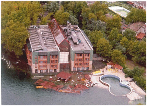
FIGURE 3.5 Many apartment buildings on the fringe of the river delta at Golcuk, Turkey, slid into the sea during the Izmit earthquake of August 17, 1999. Land-use planning that accounts for the instability of young deltaic sediments could substantially reduce loss of life and property in future earthquakes. SOURCE: A. Barka, Istanbul Technical University.
displacements can literally rip structures apart. Lateral spreading tends to allow material to fill topographic depressions, such as streams and rivers, causing the channels to narrow and the flow to become dense—a major source of damage to bridges during earthquakes (22). A more recent case of lateral spreading occurred during the August 17, 1999, Izmit, Turkey earthquake (M 7.4) when unconsolidated, water-saturated deltaic sediments collapsed into the sea (Figure 3.5), resulting in numerous deaths. Lateral spreading or landsliding can also be caused by the shaking-induced loss of shear strength in certain types of “quick” or “sensitive” layers of salt-leached, clay-rich marine sediments. The spectacular damage to the Turnagain Heights district of Anchorage during the great 1964 earthquake (M 9.2) (Box 2.3) has been attributed to large (150- to 180-meter) displacements within a relatively thin zone of the Bootlegger Cove clay, 25 meters below the surface (23).
Empirical relations for predicting the extent and severity of liquefaction events have been developed through field studies, theoretical modeling, and laboratory experiments using geotechnical centrifuges. Less ex-
tensive research has been conducted on mass wasting in unsaturated conditions. However, postseismic mapping of landslides and rockfalls has shown that rock type, steepness of slope, and proximity to seismic source are the major contributors to failure. In 1990, California enacted the Seismic Hazards Mapping Act, which significantly broadened the responsibilities of the state geologist to include mapping liquefaction and landslide hazards. Mitigation money from the Federal Emergency Management Agency (FEMA) under the Stafford Act after the Northridge earthquake and fees from construction building permits provide funding for these mapping efforts (e.g., Figure 3.6).
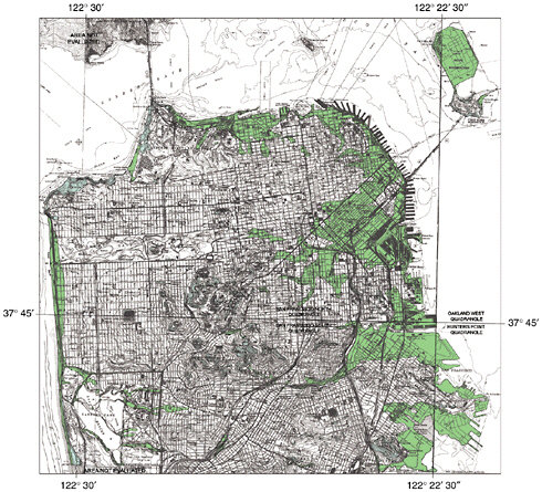
FIGURE 3.6 Map of landslide and liquefaction hazards for the city of San Francisco. Areas of high landslide potential are shown in blue, and areas of high liquefaction potential are shown in green. SOURCE: California Division of Mines and Geology, <http://www.consrv.ca.gov/dmg/shezp/maps/m_sf.htm>.
Tsunamis
When a large earthquake occurs under the ocean, the vertical motion of the seafloor displaces the water column, causing gravitational instability; the potential energy change of the water column converts to kinetic energy, forming a tsunami, or seismic sea wave. (Although this tectonic mechanism is the most common cause of tsunamis, they can also be generated by submarine landslides or mass debris entering the sea from volcanic eruptions.) Tsunamis have wavelengths of tens to hundreds of kilometers, depending on the horizontal dimensions of the source, and travel over long distances with little attenuation. Their speed depends on ocean depth, increasing from 500 kilometers per hour in a 2-kilometer-deep ocean to about 900 kilometers per hour in a 6-kilometer-deep ocean (24). The waves are refracted away from regions of deep water and scattered from local bathymetric highs. Accurate bathymetric maps can be used to simulate tsunami propagation (Figure 3.7) and predict the arrival time and, if the details of the source are known, the amplitude. As the tsunami enters shallower water, the propagation speed and wavelength decrease, and the amplitude increases. Transgression of the shoreline by large tsunamis causes runup (measured as the water rise above the shoreline level, in meters), often as a very fast-rising tidal wave that floods well past the normal high-water level, sometimes as a turbulent bore. Considerable structural damage can occur to ports and other coastal installations from the exceptional currents generated during runup and withdrawal and the impact of debris entrained by these currents.
Tsunamis claimed more than 100,000 lives in the twentieth century. In some cases, the destruction occurred far from the earthquake epicenter, as on April 1, 1946, when an M 7.1 earthquake in the Aleutian Islands triggered a Pacific-wide tsunami. A runup of 8.1 meters occurred 4.9 hours later at Hilo, Hawaii, causing $26 million in damage and 159 deaths (Figure 3.8). This disaster led to the first Seismic Sea Wave Warning System, established in Hawaii on August 12, 1948. Additional systems have since been deployed, including those designed to provide rapid warnings of tsunami hazards from local earthquakes, when the runups occur soon after ground shaking (see below).
Although these warning systems can estimate tsunami arrival time accurately, their prediction of wave amplitude and coastal runup is much less precise. Major uncertainties are associated with the tsunami excitation process. Although tsunami amplitude depends on the total deformation of the seafloor (and should therefore be proportional to low-frequency seismic moment), it correlates poorly with standard earthquake magnitude determined at high frequencies (25). Moreover, seafloor deformation in the epicentral region depends on the depth and orientation of the fault-
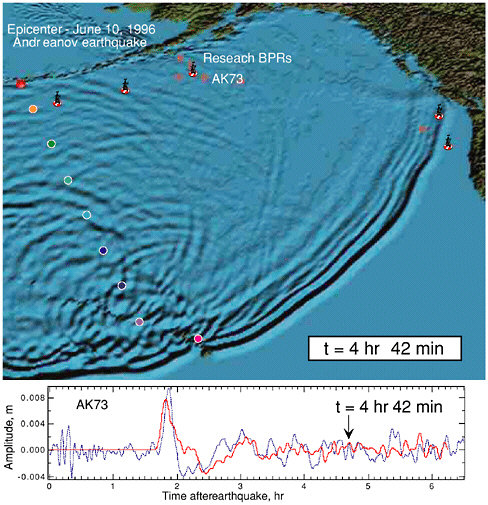
FIGURE 3.7 Numerical simulation of tsunami radiation into the Pacific Ocean by an M 7.7 earthquake of June 10, 1996, in the Andreanov Islands 50 miles southwest of Adak, Alaska. Top: Wavefield calculated at 4 hours and 42 minutes after the event. Bottom: Comparison of observed (blue line) and computed (red line) waveforms from bottom pressure recorder AK73. SOURCE: National Oceanic and Atmospheric Administration, Pacific Marine Environmental Laboratory.
ing. Subduction-zone earthquakes as large as the 1946 Aleutian event occur several times each year, for example, but they only rarely produce such a big tsunami. Fault ruptures that propagate at anomalously low velocity, and thus have a long source duration, appear to be responsible for some large tsunamis, whereas others are evidently due to landslides triggered by earthquakes or volcanic eruptions (26).
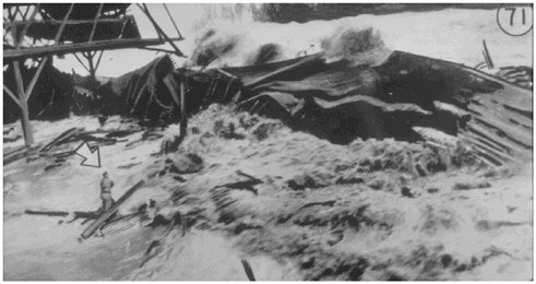
FIGURE 3.8 Tsunami generated by the April 1, 1946, Aleutian Islands earthquake, breaking over Pier No. 1 in Hilo Harbor, Hawaii. Man in the foreground was one of the 159 fatalities in the Hawaiian Islands. SOURCE: National Oceanic and Atmospheric Administration, National Geophysical Data Center.
Tsunami prediction is also limited by the complex hydrodynamics of tsunami propagation and runup. Considerable effort has been devoted to rigorously defining the effects of nonlinearity and dispersion for tsunamis that propagate over long distances (27). The 1992 Flores Island and the 1993 Okushiri Island tsunamis prompted investigation of the phenomenon of tsunami trapping near islands (28). Runup laws that relate the offshore waveform to maximum runup onshore have been derived theoretically, and these studies have been augmented by laboratory and numerical investigations of the runup associated with breaking waves and shallow beach slopes (29). Efforts are also under way to formulate site-specific inundation models near coastal population centers, which will require more accurate numerical methods that take into consideration topographic effects and bottom friction in the inundation region (30). Local tsunamis generated along continental margins pose a special problem for hazard mitigation (31). A particular issue is the excitation of edge waves, which can result in large-amplitude late arrivals, as observed in a tsunami generated by the 1992 Cape Mendocino, California, earthquake (32).
3.2 SEISMIC HAZARDS IN THE UNITED STATES
A major task for earthquake science is to characterize the geographical distribution of seismic hazards. At a particular location, the primary
hazard of ground shaking can be quantified by probabilistic seismic hazard analysis (PSHA; see Section 2.7). Extending PSHA calculations to all points in a region generates a seismic hazard map, which conveys the spatial variations in the maximum expected intensity of shaking needed for building codes, loss estimation, and other risk mitigation applications. This section describes seismic hazards in the United States, using the national seismic hazard maps as a guide.
National Seismic Hazard Maps
Seismic hazard maps depict the ground-motion intensity that will be exceeded with a specified probability during a specified exposure time (See section 2.7). In 1996, the U.S. Geological Survey (USGS) released a new series of national seismic hazard maps (33) that contoured four measures of earthquake intensity—PGA and response-spectrum accelerations at frequencies of 1, 3, and 5 hertz—at three hazard levels, given by the 2 percent, 5 percent, and 10 percent probabilities of exceedance in 50 years. When used to determine the seismic-safety criterion in structural design, a lower exceedance probability specifies a higher shaking intensity and is assigned to structures whose failure would cause more severe consequences. The highest probability level depicted in the national maps (10 percent probability in 50 years) corresponds to a mean return period of 475 years (34) and is often used in the life-safety design of buildings, while the lowest (2 percent probability in 50 years) corresponds to a mean return period of 2475 years and is used in collapse-prevention design (35). Figure 3.9 compares the maps of PGA at these two hazard levels for firm-rock sites (B-C boundary in the NEHRP site classification) in the conterminous United States.
The 1996 maps incorporated a range of new information on earthquake hazards derived from NEHRP-sponsored research, such as the discovery of great prehistoric subduction-zone earthquakes in the Pacific Northwest, and recurrence rates and magnitudes of large earthquakes in the New Madrid and Charleston areas estimated from paleoliquefaction studies. The database for the western United States included catalogs of geologic slip rates, paleoseismic chronologies, and geodetic measurements comprising approximately 450 faults. In the calculation of expected intensities, earthquake recurrence times were estimated from geologic slip rates using two alternative hypotheses, a characteristic earthquake model and a truncated Gutenberg-Richter model. Results from competing models for fault recurrence, seismicity distribution, and attenuation relations were combined via a logic-tree formalism.
The process for developing the national seismic hazard maps involved an extensive dialogue between the geoscience and engineering communi-
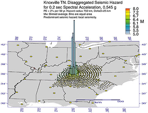
ties, directed at improving the applicability of these maps as risk mitigation tools. This effort has paid off in greater utilization (see Section 2.7). Utilization has also been enhanced by the availability of the data and data products that went into the map calculations. An important data product for specialized applications is the disaggregation of the hazard at a map point into the individual earthquake sources (36). (Examples are shown for Knoxville, Tennessee, in Figure 3.10.) Such disaggregations identify which potential earthquakes dominate the hazard for a given site. These sources can then be used as scenarios for constructing ground-motion time histories needed to design critical facilities, conduct emergency management exercises, and estimate earthquake losses.
California
California has the highest levels of seismic hazard in the lower 48 states because more than 75 percent of the relative motion between the Pacific and North American plates occurs as active faulting within its borders. The cumulative fault slip at each latitude from the Mexican border to Cape Mendocino averages more than 3.5 meters each century. California seismic hazard is dominated by the San Andreas system. This “master fault” of the plate boundary has a documented history of earthquakes as large as M 8. Two of its four major segments have broken in large, historic events: a 420-kilometer segment (Cape Mendocino to San Juan Bautista) during the 1906 San Francisco earthquake and a 350-kilometer segment (Parkfield to Wrightwood) during the 1857 Fort Tejon earthquake. The frequency of large events on the 1906 segment remains poorly constrained, but paleoseismic investigations suggest a mean recurrence interval of about 250 to 300 years. The frequency of large events along the 1857 segment is better documented, varying by locality from about 50 to 300 years. These segments are separated by the “creeping section” of the San Andreas (San Juan Bautista to Parkfield), where most of the strain is taken up as aseismic creep and large earthquakes appear to be absent. According to paleoseismic data, the 200-kilometer-long southernmost segment (Wrightwood to Bombay Beach) has broken in at least four major earthquakes since A.D. 1000. The last rupture occurred circa 1680, so this segment appears to be overdue for another.
Auxiliary strike-slip faults of the San Andreas system are also hazardous. Over the past century alone, the Imperial, San Jacinto, Elsinore, and Newport-Inglewood faults of southern California have together produced more than a dozen earthquakes larger than M 6. In the San Francisco region, the San Andreas fault splays into several branches. One of the branches on the east side of San Francisco Bay, the Hayward fault, was
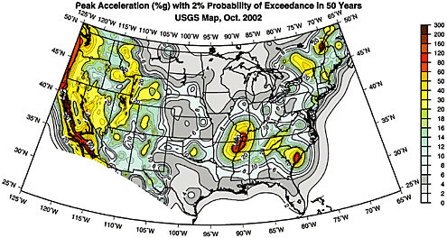
FIGURE 3.9 Probabilistic seismic hazard maps for the conterminous United States. Left panel: Peak ground acceleration with a 2 percent chance of exceedance in 50 years. Right panel: PGA with a 10 percent chance of exceedance in 50 years. The region of highest hazard lies along the San Andreas fault and the Transverse Ranges in California, with a branch extending into eastern California and western Nevada. High hazards are also found along the coast of the Pacific Northwest and in a zone following the intermountain seismic belt. In the central and eastern United States, the highest hazard areas are New Madrid, Missouri; Charleston, South Carolina; eastern Tennessee; and portions of the Northeast. SOURCE: U.S. Geological Survey, <http://geohazards.cr.usgs.gov/eq/>.
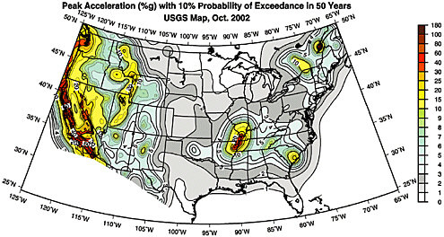
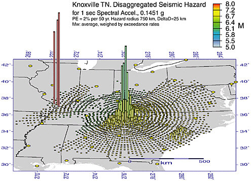
FIGURE 3.10 Disaggregated seismic hazards for Knoxville, Tennessee, for response-spectrum acceleration at 1 hertz (left panel) and 5 hertz (right panel). The height of the vertical bars is proportional to the level of hazard produced by individual earthquakes in that map cell. The color of each bar indicates the dominant magnitude contributing to the hazard. At 1 hertz, the greatest hazards come from very large earthquakes in the New Madrid seismic zone (red bars in southern Illinois) and from local intermediate-magnitude events (green bars near Knoxville); potentially large earthquakes near Charleston also make significant contributions (yellow bars in eastern South Carolina). At 5 hertz, the seismic waves from the more distant sources are more severely attenuated, and the hazard is dominated by the smaller, more local events (blue bars near Knoxville). Yellow circles are cities. SOURCE: U.S. Geological Survey, <http://geohazards.cr.usgs.gov/eq/>.
the source of a large (M about 6.8) earthquake in 1868. In 1990, the Working Group on California Earthquake Probabilities estimated that the chance of an M = 6.7 earthquake on the Hayward-Rogers Creek fault system before 2030 is approximately 36 percent. The same group concluded, in a major reassessment, that the chance of an earthquake larger than M 6.7 in the Bay area over the next 30 years was about 70 percent (37). However, it is uncertain how much of the slip along the northern portion of the Hayward fault is accommodated by aseismic creep, rather than by large earthquakes (38).
The S-curve in the San Andreas fault north and east of Los Angeles is an example of a restraining bend that results in compressive deformation taken up by auxiliary reverse faults. These have produced damaging thrust-type earthquakes, including the 1952 Kern County (M 7.5), 1971 San Fernando (M 6.7), and 1994 Northridge (M 6.7) events. The latter occurred on a blind thrust (i.e., a shallow-dipping reverse fault that does not crop out at the Earth’s surface). Blind thrusts are common in compressional regimes where thick sections of soft sediments cover active faulting in basement rocks. Rather than propagate to the surface, the faulting de-forms the overlying sediments into distinctive fold structures (Figure 3.11). Because they lack surface scarps, blind thrusts are more difficult to identify, and they cannot be studied with paleoseismic trenching techniques; rather, their geometry and slip rates must be inferred using structural and geomorphic methods supplemented with seismologic and geodetic data. From this type of neotectonic analysis, geologists have estimated that the blind thrust fault that produced the 1994 Northridge earthquake is slipping at about 1.5 millimeters per year and that the recurrence interval for such events is on the order of 1700 years (39). In 1995, the Southern California Earthquake Center (SCEC) published a major assessment of earthquake hazards that, for the first time, merged results from geodetic measurements, neotectonic slip rates, and historic seismicity into a probabilistic seismic hazard analysis for southern California (40). That report concludes that earthquakes of M 7.2 to 7.6 have occurred and will recur in the Los Angeles region to relieve the contractional strain accumulating across the “Big Bend” of the San Andreas.
The eastern Mojave shear zone, which splays off the San Andreas system just east of the Big Bend, accommodates a portion of the Pacific-North American plate motion (0.7 to 1.2 meters per century) (41). It has produced a series of major earthquakes during the last decade, including the 1992 Landers (M 7.3) and 1999 Hector Mine (M 7.1) earthquakes. Along the eastern side of the Sierra Nevada, the Mojave shear zone has also been a source of high seismicity throughout history, including the 1872 Owens Valley earthquake (M 7.6). Other fault systems that contribute to seismic hazards in California include the Mendocino fracture zone
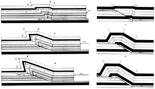
FIGURE 3.11 Two types of blind faults and the distinctive deformation of adjacent crustal blocks associated with them. In the case of a fault that steps from one flat surface to another across a shallow-dipping ramp, a symmetrical fault-bend fold forms and lengthens with increasing fault displacement. In the case of a fault that ramps up from a flat surface and is propagating upward from the top of a shallow-dipping ramp, a highly asymmetrical fault propagation fold forms. SOURCE: J. Suppe, Geometry and kinematics of fault-bend folding, Am. J. Sci., 283, 684-711, 1983; Reprinted by permission of the American Journal of Science; J. Suppe, Principles of Structural Geology, Prentice-Hall, Englewood Cliffs, N.J., p. 351, 1985.
in northern California and the Cascadia subduction zone off the coast north of the Mendocino triple junction.
Pacific Northwest
The band of high seismic hazard paralleling the Pacific coast, which includes the Portland and Seattle-Tacoma metropolitan areas, comes from three tectonically distinct sources: great earthquakes on the main thrust of the Cascadia subduction zone; shallow earthquakes in the upper crust above the subduction zone; and deeper earthquakes within the subducting lithosphere of the Juan de Fuca plate. The 1000-kilometer-long subduction interface that runs along the continental margin from Cape Mendocino to the northern tip of Vancouver Island appears to be locked and accumulating strain, rather than slipping aseismically as previously believed (42). Brian Atwater and his colleagues (43) have documented seven
great subduction earthquakes during the last 3500 years, recorded as irregularly spaced episodes of sudden submergence in estuarine sediments. A combination of radiocarbon and tree-ring dating pinpointed the most recent submergence event to the winter of 1699-1700, and K. Satake correlated this event with a mysterious tsunami recorded along the Japanese coast on the night of January 26, 1700 (44). He estimated the size of this event at about M 9.
The Seattle fault is one of several shallow thrust faults accommodating north-south compression in the Puget lowlands (Figure 3.12). The
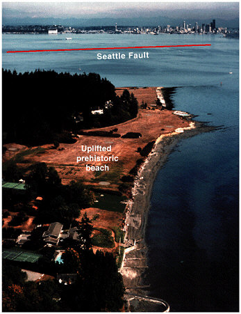
FIGURE 3.12 Photograph of uplifted beach from prehistoric earthquake on the Seattle fault, looking east across Puget Sound from Bainbridge Island toward Seattle, Washington. The broad, flat, grass-covered surface in the foreground is a prehistoric beach that was uplifted about 7 meters during a large earthquake (M > 7) about 1100 years ago. The earthquake was caused by slip on a portion of the Seattle fault, whose location beneath Puget Sound is indicated by the red line. SOURCE: U.S. Geological Survey.
frequency of large earthquakes on this fault is poorly determined, but paleoseismic data show that the most recent large earthquake occurred about 1100 years ago and was associated with as much as 7 meters of uplift, major landslides, and tsunamis in Puget Sound (45). Use of laser altimetry (e.g., light detection and ranging [LIDAR]) for precise mapping of topography has led to the identification of splays of the Seattle fault. Geologists who have trenched these splays find that earthquakes of M 6.5 or greater recur as often as about 1000 years.
Earthquakes damaging to Seattle, Tacoma, and Olympia in 1949 (M 7.1), 1965 (M 6.5), and 2001 (M 6.8) were caused by rupture at depths of 50 to 60 kilometers within the subducting slab of the Juan de Fuca plate. Owing to this greater depth, the shaking intensity is lower than that of comparable shallow events. For example, the PGA recorded for the February 28, 2001, Nisqually earthquake was only about 30 percent of gravity, compared with values more than 100 percent of gravity observed for the 1994 Northridge event (M 6.7). It nevertheless caused significant damage over a broad region.
Intermontane West
The seismic hazards in the intermontane regions of the western United States are dominated by high but relatively diffuse seismicity accommodating oblique crustal extension. The total extension rate between stable North America and the Sierra Nevada-Great Valley block is estimated by Global Positioning System (GPS) geodesy to be 1 ± 0.1 meter per century (46). Most is concentrated in the Basin and Range, a geologic province characterized by dozens of tilted, 10- to 30-kilometer-wide crustal blocks that form high mountain ranges alternating with deep basins. Earthquakes occur both on the normal faults bounding the mountain ranges and on the strike-slip faults that cut across the province.
The late Cenozoic normal faults are distributed relatively uniformly in the Basin and Range, but the historic and instrumental seismicity is concentrated in the central Nevada seismic belt, along the western margin of the province in eastern California and western Nevada, and the intermountain seismic zone, along the eastern edge of the province, from southern Nevada across central Utah to southwestern Montana and central Idaho. From 1915 to 1954, a sequence of five large earthquakes (M 6.8 to 7.7) ruptured adjacent segments of the central Nevada seismic belt. Another historically active area is the intermountain seismic zone centered on Yellowstone National Park in northwestern Wyoming, where a mantle hot spot is causing uplift and volcanism (47). The 1959 Hebgen Lake earthquake ruptured a normal fault adjacent to the Yellowstone area, and the 1983 Borah Peak earthquake (M 7.5) occurred on a range-
front fault farther to the west in southeast Idaho. Paleoseismic studies show that even the most active faults in this region produce such big earthquakes only every few thousand years. Based on the Holocene average, the current level of activity appears to be abnormally high in the central Nevada seismic belt and abnormally low in the intermountain seismic belt. One area of future concern is the Wasatch front traversing the populated areas of Salt Lake City and Provo, where large, prehistoric earthquakes have been documented by paleoseismic techniques along six segments of front-bounding fault, but no large earthquakes have occurred in the historic period (Figure 2.4).
Central United States
Seismic activity decreases markedly in the stable continental interior, east of the Rockies. However, seismic waves propagate more efficiently through the colder, thicker lithosphere that underlies this region than through the hotter crust and upper mantle of the western United States (48). Earthquakes of comparable magnitude can consequently cause damage over larger areas. For instance, a large earthquake in southeastern Missouri on December 16, 1811, generated strong shaking (Modified Mercalli Intensity V or greater) over an area at least five times bigger than in the 1906 San Francisco earthquake, which had a larger magnitude. This was the first in a violent sequence of earthquakes that occurred for the next several months along an abandoned set of Paleozoic extensional faults called the Reelfoot Rift (Figure 3.13). The large magnitudes of these earthquakes, combined with the relatively short return periods for events of similar size found from paleoseismic studies, imply that the central Mississippi Valley has the highest seismic hazard east of the Rocky Mountains, although the level of this hazard remains controversial (Box 3.1).
Other areas of potential seismic hazard in the central United States include eastern Kansas and Nebraska, which has been the site of two M 5 earthquakes in the past 150 years. Liquefaction features indicate that M 6.5 to 7.5 earthquakes with recurrence times of a few thousand years have occurred in the Wabash Valley of southern Indiana and Illinois (49). The Meers fault in southern Oklahoma has generated two large earthquakes (M 7) in the past 3000 years (50), and the Cheraw fault in southeast Colorado has produced M 7 earthquakes in the past 10,000 years (51).
Eastern United States
Most people think of the eastern United States as seismically benign. At present, this region lies near the center of the North American plate, far from active plate boundaries to the east and west. The histori-
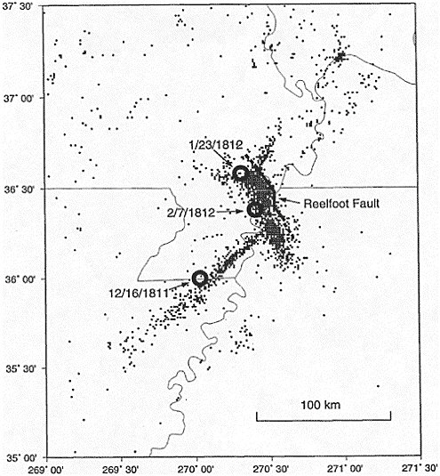
FIGURE 3.13 Structural setting of the New Madrid seismic zone showing the locations of historical earthquakes (M < 5) detected by regional seismic networks from 1974 to 1993. The circles show the estimated epicenters of the large New Madrid earthquakes of 1811-1812. SOURCE: S.E. Hough, J.G. Armbruster, L. Seeber, and J.F. Hough, On the Modified Mercalli intensities and magnitudes of the 1811-1812 New Madrid earthquakes, J. Geophys. Res., 105, 23,839-23,864, 2000. Copyright 2000 American Geophysical Union. Reproduced by permission of American Geophysical Union.
|
BOX 3.1 The New Madrid Earthquakes of 1811-1812 For eight weeks during the winter of 1811-1812, the frontier town of New Madrid, on the Mississippi River in the southeast corner of Missouri, was rocked by a series of strong earthquakes. The initial event of December 16, 1811, was followed by a slightly smaller shock six hours later and two other principal shocks on January 23 and February 7, 1812. The last was the largest, destroying New Madrid, damaging houses in St. Louis, and cracking chimneys 600 kilometers away. The events were widely felt through eastern North America and as far away as Boston. Witnesses reported spectacular secondary effects, including soil liquefaction, landslides, sand and water fountains, and changes in the flow of the Mississippi River. Aftershocks strong enough to be felt continued through 1817. In 1815, Congress passed the first relief act for an earthquake disaster, which granted new land in unaffected regions to farmers displaced by ground disturbances and flooding. The first scientific study of the New Madrid earthquakes, based on landforms and historical accounts, was not published until a century later.1 Research by Otto Nuttli at St. Louis University placed better bounds on the earthquake magnitudes and locations, and he explained the larger isoseismal zones in terms of seismic-wave attenuation, which is much lower in the stable continental lithosphere of the central and eastern United States.2 Monitoring by a regional seismic network began in 1974 and has delineated a complex set of interlocking faults in a geologic structure known as the Reelfoot Rift, which spans a 2000-square-kilometer region overlapping the borders of Missouri, Arkansas, Tennessee, Kentucky, and Illinois. Nuttli’s work implied that the moment magnitudes of the New Madrid earthquakes were very large—as high as 8.1 for the February 7, 1812, event—and from the dating of paleoliquefaction events, geologists were able to identify at least two events of similar size in the previous thousand years.3 Questions have been raised recently, however, as to whether these levels are overestimates. A reanalysis of isoseismal areas of the three largest shocks in the 1811-1812 sequence has lowered the estimates by a half an order of magnitude or more,4 and a new GPS survey has failed to detect the high levels of regional strain that would be expected for an area where great earthquakes occur every 500-1000 years.5 This controversy underlines the need for continuing efforts to understand the seismic hazards of the continental interior. |
cal record includes a number of moderate to large earthquakes, however. The greatest seismic hazard in the southeastern United States is thought to be near Charleston, South Carolina. In 1886, an M 7.3 earthquake caused widespread damage and liquefaction in a broad area. Recent studies of paleoliquefaction features indicate that earthquakes the size of the 1886 event occur about every 600 years (52). The geological structure responsible for these events is still uncertain, although satellite images and river drainage deflections suggest a linear feature that could be the expression of a fault in the basement beneath the thick coastal plain sediments (53). Seismicity in eastern Tennessee encompasses the cities of Knoxville and Chattanooga (54) in a 200-kilometer-long, north-east-trending band. No historic earthquakes greater than body wave magnitude (mb) 4.5 have occurred within this band, but the high seismicity is consistent with the potential occurrence of larger events. Other notable earthquakes in the southeast include the 1897 Giles County earthquake (mb 5.5) in western Virginia and the 1916 Jefferson County (mb 5.1) event near Birmingham, Alabama.
The largest historic event in the northeastern United States was the Cape Ann earthquake (mb 6) off the coast of Massachusetts in 1755. A repeat of this event would have serious consequences for Boston, which contains numerous older, more vulnerable structures. Similar concerns have been raised for the New York metropolitan area, which experienced moderate (M 5) earthquakes in 1737 and 1884. Analysis of seismicity along the Boston-to-Washington corridor suggests that an mb 6 or greater event should occur about every 400 years (55). Such an earthquake would likely cause substantial damage.
Unlike plate boundary zones, where the source of the deformation is fairly clear, the seismicity of the central and eastern United States arises from deformations that are poorly described and not well understood. They are most commonly associated with relic geologic features on the southern periphery of the ancient Canadian craton, inherited from previous episodes of plate tectonics. These epicratonic features often comprise buried fault systems of formerly active plate boundaries. To understand why they have been reactivated as weak structures in present-day tectonics will require better data from regional seismic and geodetic networks, along with more extensive paleoseismic mapping at the surface and subsurface imaging by active geophysical techniques.
Alaska
The hazard map of Alaska is dominated by the Alaska-Aleutian megathrust, the longest fault zone with the highest rate of seismicity in the United States (Figure 3.14). It stretches 3600 kilometers from Kam-
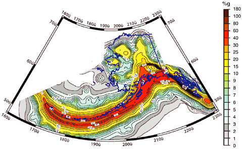
FIGURE 3.14 Alaska seismic hazard map showing peak ground acceleration with a 10 percent chance of exceedance in 50 years. SOURCE: U.S. Geological Survey, <http://geohazards.cr.usgs.gov/eq/>.
chatka to the Gulf of Alaska, and it accommodates most of the convergence between the Pacific and North American plates, which ranges from 6.3 meters per century near the Kenai Peninsula to 8.6 meters per century in the western Aleutian Islands. The largest historic earthquake in the United States (M 9.2) was generated in 1964; its ground shaking and liquefaction caused spectacular damage to Anchorage (Box 2.3). The fault plane responsible for this huge event was equivalent to the area of New York State moving an average of about 10 meters. The megathrust was also the source of great earthquakes in 1957 (M 9.1) and 1965 (M 8.7). Elsewhere in Alaska, major strike-slip faults, including the Denali and Fairweather faults, traverse the interior of Alaska and pose a substantial danger to Juneau. The Denali fault is about 1000 kilometers long and has a slip rate of 0.2 to 1.0 meter per century, but has not ruptured in the past few centuries. Earthquakes in the crust and subducted slab pose a significant hazard to Anchorage and Fairbanks.
Hawaii
The Hawaiian Islands were formed by the passage of the Pacific Plate over a mantle hot spot. This hot spot persists today, its eruptive centers on
the southeast side of the “Big Island.” Consequently, the largest earthquakes and highest level of seismic hazard in the Hawaiian Islands occur in the southeast portion of the Big Island. The seismicity generally decreases westward along the island chain, reflecting the increasing age of the islands (Figure 3.15). The M 7.2 Kalapana earthquake in 1975 ruptured a nearly horizontal surface at a depth of about 9 kilometers. This earthquake, and presumably the M 7.9 shock in 1868, moved the southern flank of the Big Island seaward in response to stress generated by intrusion of magma into the Kilauea and Mauna Loa volcanoes. Earthquake-induced landslides, the most recent of which occurred about 100,000 years ago, appear to have removed a sizable chunk of Mauna Loa’s southwest flank, sending sea waves laden with coral blocks several hundred meters onto the coast of neighboring islands. Several M 6 to 7 earthquakes have occurred elsewhere in the Hawaiian Islands in the past 200 years, including events near Kilauea caldera and the Kona coast of the Big Island and in the Maui-Molokai region.
3.3 SEISMIC HAZARDS AROUND THE WORLD
Most of the world lacks the detailed information on fault activity comparable to that available in the United States. In many tectonic regions, especially in underdeveloped countries, the seismic stations for delineating active structures are sparse; neotectonic and paleoseismic data are not yet available even on the most dangerous faults; and the efforts to investigate and quantify seismic hazards are weak or nonexistent. Recognizing this need, the United Nations initiated a Global Seismic Hazard Assessment Program (GSHAP) as a demonstration project for the International Decade of Natural Disaster Reduction (IDNDR, 1990-1999). In December 1999, this program released the first global seismic hazard map based on a consistent probabilistic seismic hazard analysis (56), reproduced here as Figure 3.16. This map, in combination with the global seismicity map (Figure 2.10), furnishes the guide for a brief tour of seismic hazards around the world.
Convergent Environments
Most of the global seismic energy release is in subduction-zone earthquakes (Figure 3.17). Subduction zones are marked by intermediate- and deep-focus seismicity that defines the Wadati-Benioff zones of the subducted lithospheric slabs, which dip beneath volcanic arcs in places such as Japan, the Aleutian Islands, and the Cascadian province of the western United States (57). The interface between the subducting and overriding lithosphere is usually well expressed in seafloor bathymetry, commonly
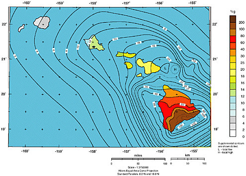
FIGURE 3.15 Hawaii seismic hazard map showing peak ground acceleration with a 10 percent chance of exceedance in 50 years. SOURCE: U.S. Geological Survey, <http://geohazards.cr.usgs.gov/eq/>.
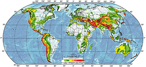
FIGURE 3.16 The GSHAP global seismic hazard map, depicting the peak horizontal ground acceleration for rock sites with a 10 percent probability of exceedance in 50 years (corresponding to a return period of 475 years). The map was compiled from existing national seismic hazard maps and new regional maps developed under the auspices of GSHAP. Except for the United States and parts of the former Soviet Union, the map is based on recurrence times derived entirely from historic seismicity, assuming a Gutenberg-Richter recurrence relation (Equation 2.5). SOURCE: D. Giardini, G. Grünthal, K. Shedlock, and P. Zhang, The GSHAP global seismic hazard map, Ann. Geofisica, 42, 1225-1230, 1999.
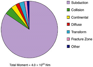
FIGURE 3.17 Comparison of seismic moment distribution for different tectonic environments, excluding southern Chile, from 1900 to 1989. Great earthquakes associated with circum-Pacific subduction dominate the recent energy release. In fact, about 30 percent of the global total for the last century was released in a single event—the great Chilean earthquake of 1960 (M 9.5). SOURCE: Modified from J.F. Pacheco and L.R. Sykes, Seismic moment catalog of large shallow earthquakes, 1900 to 1989, Bull. Seis. Soc. Am., 82, 1306-1349, 1992. Copyright Seismological Society of America.
by a deep ocean trench or a demarcation between undeformed oceanic-plate seafloor and highly deformed seafloor of the overriding plate. The dip of the subduction interface determined from seismicity and focal mechanisms ranges geographically from nearly flat to nearly vertical. Steeper subduction interfaces, such as that beneath the Mariana Island arc, usually produce smaller earthquakes (58); they commonly involve older, denser oceanic lithosphere and trench-normal extension of the overriding plate, sometimes in the form of back-arc spreading. Shallow-dipping subduction zones, like that beneath Chile, tend to produce larger earthquakes and commonly involve younger oceanic lithosphere. The percentage of the total long-term slip on a subduction interface expressed in earthquake ruptures, commonly referred to as the degree of seismic coupling, is believed to range widely (59). For example, the subduction zone that separates Indonesia from the Australian plate appears to be highly coupled offshore Sumatra, but poorly coupled offshore Java (60), and this contrast in reflected in the higher hazard for the Sumatran portion and the lower hazard for the Javan portion of the subduction zone.
In addition to reverse slip on the main plate interface and deeper seismicity within the Wadati-Benioff zones, large earthquakes take place
in both the subducting slab (foot wall) and the overriding plate (hanging wall). Many of Japan’s historic, destructive earthquakes, including the 1891 Nobi and 1995 Hyogo-ken Nanbu earthquakes, were caused by shallow faults within the overriding plate. In regions of oblique convergence, relative plate motion tends to separate into two parts, a subduction component taken up by reverse dip-slip faulting perpendicular to the trench and a lateral component taken up as strike-slip faulting parallel to the trench in the overriding plate (61); examples of such strike-slip structures include the Great Sumatran fault in Indonesia, the Philippine fault, and the Median Tectonic Line of Japan. Earthquakes that occur seaward of the trench are caused by flexing of the downgoing slab. These events may accommodate either stretching or contraction of the downgoing slab along either normal or reverse faults. Two of the largest historical events in this setting—the 1977 Sumba, Indonesia (M 8.3) and the 1933 Sanriku, Japan (M 8.4) earthquakes—were caused by normal faulting of the bending subducting plate.
Continental convergence zones have generated some of history’s most destructive earthquakes. They are common throughout the broad Alpine-Himalayan belt that resulted from the closure of the ancient Tethys Ocean (Figure 3.18), but are also found behind ocean-continent subduction zones, such as the foreland fold-and-thrust belts in the eastern foothills of the Andes. The style of deformation ranges from block motions along large reverse faults that penetrate deep into the crystalline basement, as in the Pampean Ranges in northwestern Argentina and the Zagros of Iran and
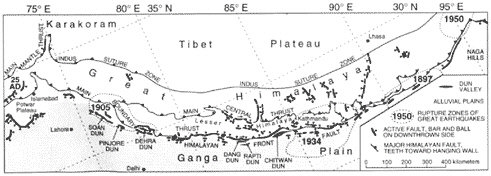
FIGURE 3.18 Four giant earthquakes—1897, 1905, 1934, and 1950—have resulted from slip on shallow thrust faults along the southern front of the Himalaya in India and Nepal. Although many active faults reach the surface in this 2000-kilometer-long region of continental convergence, the ruptures of these devastating earthquakes did not break to the surface. SOURCE: G. LeBlanc and F. Anglin, Induced seismicity at the Manic 3 Reservoir, Quebec, Bull. Seis. Soc. Am., 68, 1469-1485, 1978. Copyright Seismological Society of America.
in New Guinea, to the “thin-skinned” tectonics that characterizes crustal shortening in major sedimentary basins.
Divergent Environments
A predominance of normal faults, high heat flow, relatively low seismic-wave speed in the upper mantle, and volcanism usually characterize tectonic environments dominated by crustal divergence or extension. Oceanic spreading centers are the most common type, and their geometry and kinematics are usually fairly simple, conforming much more to the plate-tectonic ideal than their continental counterparts. Slow-spreading boundaries, such as the Mid-Atlantic Ridge, typically display a central rift valley or graben, while such features are usually absent on fast-spreading ridges like the East Pacific Rise. Most of the displacement on normal faults flanking the central rift valley occurs soon after crustal formation; as the crust moves away from the spreading center, the faults become inactive. Much of the deformation associated with seafloor spreading at the oceanic ridge crests appears to be aseismic, presumably because of the high temperatures generated by mantle upwellings, and large earthquakes in this environment are rare. Moreover, with the exception of a few places such as Iceland, most oceanic spreading centers are far removed from areas of human habitation, and their seismic activity poses little danger. Subaerially exposed spreading centers are rare and atypical, but examples in Iceland and Djibouti have offered particularly good opportunities to study this class of normal faults and their associated earthquakes (62).
Extension within continental crust can be localized in discrete rifts, such as those in East Africa (Figure 3.19) and the Baikal rift of eastern Russia, or distributed over broad regions, as in the extensional provinces of northeastern China and the Basin and Range Province of the western United States. While they share certain characteristics—high heat flow, volcanic activity, and normal faulting between horsts and graben—the issue of how these features relate to large-scale plate tectonics remains problematic. For example, the Basin and Range accommodates about 20 percent of the northwest-southeast motion between the Pacific and North American plates, but it does so along faults of north-to-northeast strike, which results in normal faulting with secondary strike-slip activity (63). This messy behavior is evidently associated with active mantle flow beneath the province.
Normal faulting is also found in association with hot spots, back-arc basins, high plateaus behind collision zones, and intercontinental rift zones. Although not very common, they pose a significant seismic hazard, and their underlying tectonic mechanisms are not well understood.
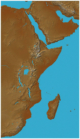
FIGURE 3.19 Spacecraft view of the African rift valleys from the Shuttle Radar Topography Mission. SOURCE: T. Farr, National Aeronautics and Space Administration.
Extension in the hanging-wall block above subduction zones, which is well documented, has produced significant earthquakes behind some circum-Pacific and Mediterranean arcs (64). In Tibet and the South American Altiplano, compression during plate collision has built large plateaus so high that they may be gravitationally collapsing toward their margins, resulting in active normal faulting within their interiors (65). At least a half-dozen north-south-trending fault systems are accommodating extension across an area of 1000 kilometers by 400 kilometers in southern Tibet (66). Other examples of active crustal extension behind collision zones include the lower Rhine graben, north of the Alpine orogenic belt. Recent paleoseismic excavations in the Roer Valley of eastern Belgium, southern Netherlands, and westernmost Germany have shown that the magnitudes of modern earthquakes (M about 5) may underestimate the maximum expectable magnitudes by at least one magnitude unit (67).
Strike-Slip Environments
Strike-slip faults release only a small percentage of total energy, yet they are found in great variety and have produced some of the most destructive and infamous earthquakes, including the 1906 San Francisco (Box 2.2) and the 1995 Hyogo-ken Nanbu (Box 2.5). The most common, but least seismic, of these lateral faults are the transform faults that connect oceanic spreading centers. Although this class includes some of the longest faults in the world—the Romanche transform in the equatorial Atlantic has been mapped as a nearly continuous fault for 950 kilometers—and the ones with the fastest slip rates (as much as 8.5 meters per century for the 480-kilometer-long Tharp transform in the southeastern Pacific), they generate earthquakes larger than M 7 rarely and M 8 almost never (68). Essentially all ridge-ridge transforms are under the oceans and therefore difficult to study, but some have been the subject of detailed oceanographic surveys (69). The low seismicity of ridge-ridge transforms is correlated with the high mantle temperature in these regions, although the peculiar mechanics of these faults may have something to do with the thinness of oceanic crust along ridge-ridge transforms and the abundance of weak, serpentinized upper mantle.
Transforms that run between trenches are far less common than ridge-ridge transforms, because they do not occur as closely spaced arrays separating trench segments. Most often, trench-trench transforms act as the lateral boundaries of large plates. They are typically many hundreds of kilometers long, involve continental lithosphere, and display complex and idiosyncratic geometry (70). Examples include the Alpine fault system of New Zealand (Figure 3.20) and the Macquarie Ridge, farther south. The latter structure generated an unusually large, enigmatic earthquake in 1989. Ridge-trench transforms connecting extensional and contractional zones also occur as lateral plate margins. The left-lateral Dead Sea fault, for example, connects the Red Sea spreading center between the African and Arabian plates to the oblique collisional Bitlis zone between the Arabian and Anatolian plates (71). The right-lateral Sagaing fault system runs through Myanmar (Burma) along the eastern edge of the Indian plate, between spreading in the Andaman Sea and convergence in the Himalayan system.
Many strike-slip faults are not transform faults; that is, they do not transform at their termini into other types of plate boundaries. A major class involves the trench-parallel strike-slip faults associated with the strain partitioning in oblique subduction zones, discussed above. Other strike-slip faults accommodate the considerable horizontal motions associated with the lateral advection of crust escaping continent-continent collision zones. The great faults in central Asia, north of India, are the most prominent cases of such indent-linked strike-slip faults, and they
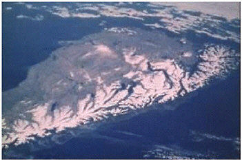
FIGURE 3.20 Spacelab photograph of New Zealand’s Alpine fault. The fault runs as a single structure for more than 500 kilometers and forms the sharp line separating the snow-covered southern Alps in the east from the low coastal plain bordering the Tasman Sea in the west. SOURCE: National Aeronautics and Space Administration.
have been the source of the Earth’s greatest (greater than M 8) historic strike-slip earthquakes (72). Another spectacular example is the 2000-kilometer-long North Anatolian fault system, along which a big chunk of Turkey is extruding westward from the Arabian-Eurasian collision. This fault system is responsible for a remarkable sequence of earthquakes propagated from its eastern sections to the west, beginning with the Erzincan earthquake in 1939 and continuing to the Izmit-Düzce sequence in 1999 (Figure 3.21) (73).
Intraplate Earthquakes
Not all major earthquakes have occurred at plate boundaries or even within the broad plate boundary zones of distributed continental deformation (Figure 3.17). The Indian, Australian, and North American cratons, in particular, are well known for their infrequent but destructive intraplate earthquakes. The 1819 Rann of Cutch earthquake, highlighted in Lyell’s Principles of Geology, occurred well within the Indian plate; meters of vertical deformation resulted from movement on a large fault in this flat, arid coastal region, causing spectacular flooding and uplift (74). The January 26, 2001, Bhuj earthquake (M 7.6) occurred in the same intraplate area, killing tens of thousands of people and causing extensive damage. A moderate (M 6.1) earthquake in 1993 in the middle of the Indian craton killed about 10,000 people (75). Between 1968 and 1988,
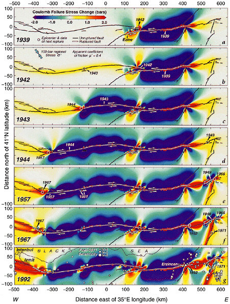
FIGURE 3.21 Map of North Anatolian fault system, showing the 53-year sequence of earthquakes and net Coulomb stress increments. Areas where the rupture-causing stresses were increased by the sequence of past events are shown in red; areas where they decreased in blue. This map, published in 1997, indicated that the city of Izmit, Turkey, was ripe for a future major earthquake. A large earthquake hit Izmit on August 17, 1999, killing over 17,000 people and causing $6 billion in direct economic losses. SOURCE: R.S. Stein, A.A. Barka, and J.H. Dieterich, Progressive failure on the North Anatolian fault since 1939 by earthquake stress triggering, Geophys. J. Int., 128, 594-604, 1997. Reproduced by permission of Blackwell Publishing.
fault rupture within the Australian plate caused several moderate earthquakes (76), and geologic reconnaissance has uncovered evidence of surface rupture associated with other intraplate earthquakes there within the past several thousand years. Paleoseismic investigations of the surficial fault ruptures associated with the earthquakes reveal that the fault had not moved for 50,000 to 100,000 years or more before the recent event (77).
Though they can occur far from plate boundaries, most intraplate earthquakes are still caused by plate-tectonic forces. The patterns of the tectonic stress that drive intraplate seismicity have been mapped using a variety of indicators—wellbore breakouts, volcanic alignments, and earthquake focal mechanisms—and their orientations are coherent over distances of 400 to 4000 kilometers (Figure 3.22). These observed trajectories generally match the predictions of intraplate stress from dynamic models of plate motions in which the primary driving forces are ridge push (compression due to gravitational sliding of newly formed lithosphere away from mid-ocean ridge highs) and slab pull (tension due to the gravitational sinking of the old subducting slabs). The spatial and temporal patterns of intraplate seismicity remain poorly understood, however. In some cases, the stress that causes these earthquakes may come from nontectonic sources, such as the withdrawal of large continental ice sheets. Reservoir loading and subsequent water infiltration are significant factors in generating some intraplate earthquakes.
3.4 ESTIMATING EARTHQUAKE RISK
Earthquake loss estimates are forecasts of damage and human and economic impacts that may result from future earthquakes. Seismic retrofitting and earthquake-resistant design involve substantial investments (Section 1.1), so it is necessary to measure the consequences of earthquakes in economic terms (i.e., dollars) that allow rational trade-offs between the known costs of preparation and the anticipated losses. The methods for constructing loss estimates have thereby become important tools for disaster preparation and decision making. Communities have begun to use such estimates in setting priorities for mitigation efforts (e.g., identifying specific structures for seismic retrofits) and developing contingencies for earthquake emergencies (e.g., alternative transport routes). Governments and insurance companies employ such estimates to anticipate the financial impact of earthquake damage. Rescue and response organizations are devising systems that make and revise damage projections in near real time based on seismic information received immediately after an earthquake, so they can focus their postseismic response where it will be most needed.
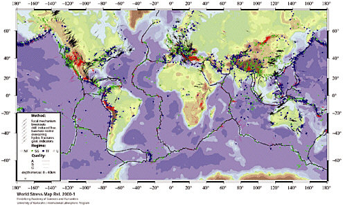
FIGURE 3.22 Global stress map. Shown are principal stress directions for normal faulting (red), strike-slip faulting (green), and thrust faulting (blue) regimes. SOURCE: B. Mueller, J. Reinecker, O. Heidbach, and K. Fuchs, The 2000 release of the world stress map, available on-line at <www.world-stress-map.org>.
Quantifying earthquake losses is difficult and uncertain, however. Earthquake forecasting is still in a primitive stage, and ground motions for a particular temblor can vary tremendously from site to site. The exposure of the built environment depends on the types and distribution of structures, and the vulnerability of each structure is a function of its construction type, age, and siting. Moreover, the true economic losses caused by earthquakes extend well beyond direct damage, owing to the consequent disruption of transportation and commerce.
In 1992, FEMA and the National Institutes for Building Standards (NIBS) initiated a program to improve the tools for calculating earthquake losses (78). The requirements included a nationally consistent inventory of buildings and infrastructure classified according to structural class; accurate estimates of the properties of potential earthquake hazards; a standardized methodology to describe and compute seismic damage to and replacement costs for buildings and lifelines, as well as secondary damage from floods, fire, and hazardous material release; and estimates of social and economic losses. This program has resulted in a public-domain software package and database termed Hazards U.S. (HAZUS) (79). HAZUS is built on a geographic information system platform and contains a nationwide inventory described by 36 model building types and 28 occupancy classes, as well as databases for populations, lifelines, and essential facilities, all except the last aggregated by census tract. In its current release, HAZUS output can include costs for repair and replacement of damaged buildings and lifelines; costs associated with loss of business revenue; casualties; people displaced from residences; quantity of debris; regional economic impacts; functionality losses (loss-of-function and restoration costs for buildings, critical facilities such as hospitals, and components of transportation and utility lifeline systems); and extent of secondary hazards (fire, flooding, and hazardous materials). As an example, Figure 3.23 shows the HAZUS estimates for direct economic losses from a repeat of the 1886 Charleston earthquake.
FEMA intends to develop HAZUS as its standard loss estimation tool for multihazard reduction efforts throughout the United States, including earthquakes, floods, and wind storms. Because the program is freely available and runs on a conventional personal computer, it offers the first opportunity to educate many computer users on the risks and vulnerabilities associated with earthquakes. Several HAZUS user groups have been formed at the state and local levels to educate community organizations about the use of this methodology to identify areas of high risk that can then be targeted for mitigation efforts (80). These educational efforts are important because users need to know the technical modules and options of this complex program sufficiently well to execute the analysis correctly (81). Moreover, there are still important limitations to the
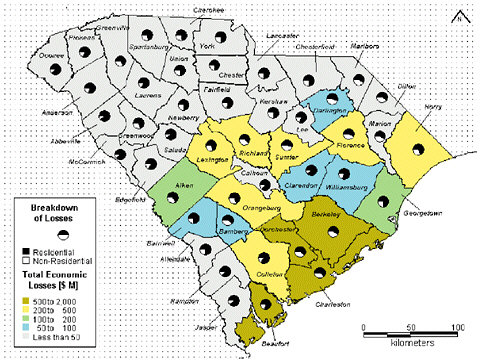
FIGURE 3.23 Map of South Carolina showing total expected economic losses (in millions of dollars) from a repeat of the 1886 Charleston earthquake, calculated using the HAZUS methodology. SOURCE: J. Bouabid, Durham Technologies, Inc., 2001.
HAZUS program that introduce uncertainties in its use. For example, HAZUS was originally designed to estimate urban losses primarily from building damage under particular earthquake scenarios. Modules for lifelines, such as transportation, water, and power systems, were added later but still need improvement, especially for estimating the effect losses from one system have on losses in other systems. HAZUS has also been expanded to estimate average annual loss at single locations, but it cannot be used to compute probabilistic aggregate loss for portfolios of properties spread over a large region and cannot take into account insurance variables, such as deductibles and coverage limits.
Requirements for improved loss estimation are driving a broad research agenda to understand the vulnerability of society to earthquakes. This will involve collecting data on the full inventory of vulnerable structures, characterizing the complete range of impacts from earthquake disasters, accurately characterizing the fragility of the built environment, and increasing the accuracy of hazard assessments for the probable earthquake sources. A particularly important issue is how to extend the meth-
odology to evaluate losses to the total performance of extended infrastructure systems, including transportation, lifelines, and acute health care. Challenging problems emerge from the interactions among these systems, for example, how damage to the regional transportation system affects local acute health care. Assessing these system-level effects will require much improved capabilities for regional-scale simulations of earthquake-induced ground motions.
3.5 REDUCING EARTHQUAKE RISK
Earthquake risk, measured in expected losses over a given period of time, depends on the seismic hazard through the exposure and on the vulnerability of the built environment (Figure 1.4). A sound strategy for the reduction of earthquake risk has four basic components: better characterization of seismic hazards; land-use policies to limit exposure to seismic hazards; preparation of the built environment to withstand future earthquakes; and rapid response to earthquake disasters.
Seismic Hazard Characterization
Characterizing and mapping seismic hazards has progressed substantially in recent years, but much work remains to be done in collecting information on active faults and incorporating new results from earthquake research into national and global seismic hazard maps. In many regions of the world, there are few data on active faults, and hazard estimates (Figure 3.16) have too little resolution and accuracy to be useful. In many areas covered with thick vegetation, even the location of these faults is unknown. Earthquake forecasting information, such as fault slip rates and dates of past earthquakes, is badly needed. Regional deformation measurements made with GPS can provide useful constraints on the expected rate of large earthquakes across zones of deformation. The time dependence of seismic hazard can be evaluated based on the dating of past earthquakes and calculations of fault interaction. The synthesis of these research efforts will lead to a detailed global map of ground-motion forecasts.
Another key goal is the development of urban seismic hazard maps for populous centers in active seismic zones. These maps would integrate the latest models of time-dependent earthquake hazard with estimates of site response and the effects of sedimentary basins, which typically underlie major cities. Such urban seismic hazard maps would have much more spatial detail than national or regional seismic hazard maps. The urban maps would show variations of seismic hazard maps over a few city blocks. Maps depicting global ground-motion forecasts and detailed seismic hazard in high-risk urban areas are criti-
cally needed tools for mitigating the loss of life and property from future large earthquakes.
Land Use
Although little can be done to alter the seismic hazard—which is geologically fixed by proximity to potential earthquake sources, local rock or soil type, and exposure to secondary ground failures—it is possible to limit the exposure to earthquake destruction by land-use policies. This approach is feasible when the hazard is localized, as in fault rupture. Unless specially designed, any structures built across an active fault will be forced to follow the ground deformation caused by fault rupture. The slip across faults in major earthquakes can be as large as 10 meters, and it is usually not practical or possible to design structures to withstand this type of displacement without severe damage. Therefore, restricting land use in active fault zones is the primary strategy for mitigating fault rupture as a seismic hazard (Box 3.2; Figure 3.24). These policies are less effective where the hazard is distributed across a broad area and all sites face significant seismic hazards; here the primary mechanisms for reducing risk are good engineering design and construction standards and effective emergency management.
Life Safety
U.S. building codes have been successful largely in achieving a high degree of life safety during earthquakes. From 1983 to 2001, in the western United States, 129 people died in eight severe earthquakes (82), while more than 160,000 people worldwide were killed in earthquakes (83). Some of this success is attributable to revisions in building codes prompted by vigorous postearthquake investigations of structural failure and improved understanding of ground motion and dynamic structural behavior (Section 2.7). One notable example is the change in codes after the near collapse of Olive View Hospital during the 1971 San Fernando earthquake. To allow for more open space on the first floor, many buildings of that era, including the hospital, were designed with a major discontinuity in the structural system between the first and successive stories, with the upper stories much stiffer and stronger. This condition was usually referred to as the “soft first story,” and the codes were modified to require that buildings have no significant discontinuities in stiffness and strength from the top floor to the foundation.
The San Fernando earthquake also exposed a deficiency in bridge design that resulted in improvements to the design standards for these structures. This earthquake also spawned a major seismic retrofit pro-
|
BOX 3.2 Fault Rupture and the Alquist-Priolo Act Surface breaks did not receive serious attention as a seismic hazard until the 1971 San Fernando earthquake, when a fault ruptured a densely populated area of Los Angeles, destroying almost 100 structures. California responded in 1972 with the Alquist-Priolo Special Studies Act, which prevented construction of new buildings for human occupancy across an active fault. For existing residences on a fault, real estate agents were required to disclose the information to potential buyers. Notably, the act did not cover publicly owned facilities, critical facilities and lifelines, or industrial facilities, many of which contain hazardous materials. The act required the state geologist to initiate a broad, and continuously updated, program of seismic hazard mapping to define the fault zones. “The earthquake fault zones shall ordinarily be one-quarter mile or less in width, except in circumstances which may require the State Geologist to designate a wider zone … The State Geologist shall continually review new geologic and seismic data and shall revise the earthquake fault zones or delineate additional earthquake fault zones when warranted by new information.” The California Division of Mines and Geology issues fault-zone maps at a scale of 1:24,000. In 1990, California enacted the Seismic Hazards Mapping Act, which significantly broadened the responsibilities of the state geologist beyond the Alquist-Priolo zones by requiring that landslide and liquefaction hazards be mapped throughout the state. Funds for this program are provided by FEMA from mitigation resources authorized by the Stafford Act and fees from construction building permits. |
gram of highway bridges in California that was greatly accelerated by the dramatic bridge failures (e.g., the Interstate 880 Cypress Viaduct in Oakland, the upper deck [east-to-west] crossing of the Oakland-San Francisco Bay Bridge, and the Struve Slough Bridge near Monterey) caused by the 1989 Loma Prieta earthquake.
Bridge seismic retrofits in California from 1971 to 1989 were limited to a cable-restrainer installation at hinges between adjoining bridge segments to prevent the ends of the spans from falling off the support seats. After the Loma Prieta earthquake, the retrofit program was broadened to include bridge columns and footings. Based on focused research, novel yet practical schemes, such as wrapping columns with steel collars or fiber-reinforced composite materials, were implemented on many vulnerable bridges to improve their seismic performance.
A notable aspect of the U.S. experience in achieving life safety is the consensus on the standards and practice for earthquake-resistant design established through the efforts of private, nonprofit organizations. Among the most important are the Structural Engineers Association of California, the Building Seismic Safety Council (BSSC) (84), the Applied Technology Council (ATC) (85), the Earthquake Engineering Research Institute (86), and the American Society of Civil Engineers (87). Backed by state and
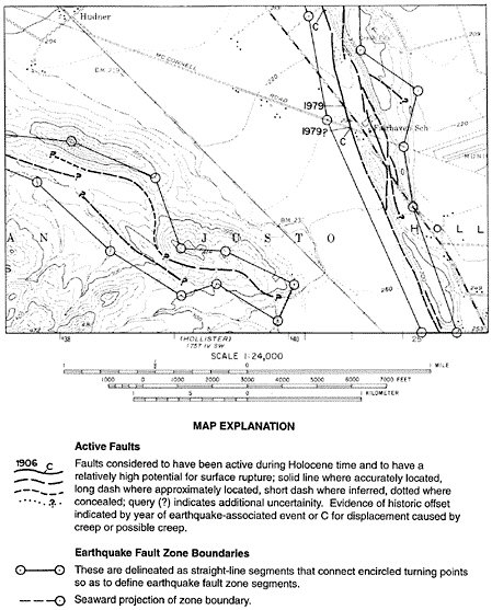
FIGURE 3.24 Alquist-Priolo zones for active faults in a region south of Hollister, California, mapped by the California Division of Mines and Geology. SOURCE: E.W. Hart and W.A. Bryant, Fault Rupture-Hazard Zones in California, California Division of Mines and Geology, Special Publication 42, Sacramento, 38 pp., revised 1997.
federal government as well as private funding, these groups have sponsored hundreds of workshops and published scores of reports, which have become the basis for revisions to the seismic provisions in building codes.
Achieving the proper balance between risk to human life and construction costs has been an ongoing objective of engineers for decades. As
the codes are evolving to more risk-based design, research will be directed to improve the probabilistic definitions of ground motion, ground movement, and structural vulnerability. At the same time, the search for improved construction materials and devices to limit the seismic forces will continue, with the objective of enhancing seismic performance at lower cost. This research will also include the investigation of new and more cost-effective techniques to stabilize poor soils prone to catastrophic failure. As in the past, this research program will be guided or redirected based on observations during future earthquakes.
Advanced Engineering Technologies
Engineering technologies that enhance protection against seismic hazards have advanced considerably over the last two decades, especially for high-value facilities. Sophisticated systems have been developed for retrofits and new construction to isolate structures from seismic shaking (base isolators) (88), to dissipate seismic energy without structural damage (hysteretic and viscoelastic devices) (89), and to dynamically modify the response of the structure in real time to counteract earthquake forces (active control systems) (Table 3.1) (90). Base isolation was introduced in the United States in the mid-1980s as a technique for seismic retrofits of historic monuments. The first application was the City Hall building in Salt Lake City, soon followed by City Halls in Oakland, San Francisco, and Los Angeles; the U.S. Appeals Court in San Francisco; and the School of Mines Building at the University of Nevada. In recent years, it has increasingly been used in new construction, where the additional costs are significantly less than for retrofitting.
The primary challenge of base isolation and other such advanced technologies is that they require sufficient understanding of the seismic response of the structure, and in some cases the soil foundation system, to identify the appropriate placement and capacity of the engineering systems. Realistic estimates of the earthquake ground motion are also required to optimally design these systems. For example, for base isolated structures, the emphasis is on the prediction of long-period ground motions; thus, fault-rupture directivity and basin response are potentially important effects that should be considered in the estimation of these motions.
Performance-Based Engineering
The seismic provisions in most current U.S. building codes are designed “to safeguard against major failures and loss of life, not to limit damage, maintain functions, or provide for easy repair” (91). The increas-
TABLE 3.1 Advanced Earthquake Engineering Technologies for Improving Seismic Performance of Structures
|
Technology |
Description |
|
Base isolation |
Flexible mounting systems (e.g., elastomeric bearings, friction pendulums, coil springs) are inserted between the building foundation and the ground. “Moats” are constructed around the structure to allow displacements of the entire building without damaging shear strain |
|
Jackets |
High-strength jackets (e.g., steel, fiber-reinforced materials) are placed over structural columns to increase the lateral strength |
|
Active control systems |
A mass is displaced in a structure to counteract and cancel earthquake-induced acceleration. These systems can be used for both wind and earthquake hazards |
|
Energy dissipaters |
Hysteretic or viscoelastic devices are inserted in the structure above the foundation to absorb energy from earthquake vibrations |
ing exposure of urban regions to significant economic loss, even in moderate earthquakes, was underscored in 1994, when the Northridge earthquake caused direct damages amounting to $20 billion and surprised engineers with extensive brittle failure of welds in nominally ductile steel moment-frame buildings. Northridge accelerated the U.S. effort to improve building practices that limit damage in future earthquakes. Implementation of what is now called “performance-based earthquake engineering” got a boost with the publication of Guidelines for the Seismic Rehabilitation of Buildings in 1997 (FEMA 273), the U.S. government’s first published consensus report on the subject (92) and, two years later, with the release of a major study on design guidelines for new steel moment-frame buildings (93).
In FEMA 273, performance-based engineering is implemented by matching the desired performance objectives, such as the four NEHRP categories described in Table 3.2, with different levels of ground motion along a seismic hazard curve, ranging from weak and frequent to intense and rare. For example, standard buildings might be required both to withstand a frequent earthquake (e.g., 50 percent probability of exceedance in 50 years) with limited economic damage to contents and negligible structural damage, ready for immediate reoccupancy, and to survive a maximum considered earthquake (2 percent probability of exceedance in 50 years) without collapsing. Although the target levels of performance for various types of structures can be specified relative to earthquake intensity (Figure 3.25), the actual procedures are still evolving. This iterative process, for which increasingly quantitative approaches are being devel-
TABLE 3.2 Building Performance Levels
|
Level |
Performance |
|
Operational Very little damage, backup utility services maintain functions |
|
|
Immediate Occupancy Building receives a “green tag” (safe to occupy) inspection rating; any repairs are minor |
|
|
Life Safety Structure remains stable and has significant reserve capacity; hazardous nonstructural damage is controlled |
|
|
Collapse Prevention Building remains standing, but only barely; any other damage or loss is acceptable |
|
|
SOURCE: Building Seismic Safety Council and Applied Technology Council, Guidelines for the Seismic Rehabilitation of Buildings, Federal Emergency Management Agency Report FEMA-273, Washington, D.C., 400 pp., October, 1997. |
|
oped, attempts to balance the costs of construction against the willingness to accept risk and uncertainty about future losses.
Conceptually, performance-based seismic engineering begins with the identification of appropriate measures of building deformation, a common choice being the maximum interstory drift (largest of the peak displacements between successive floors of the building). Each performance objective, from operational to collapse prevention, is assigned a tolerable annual probability of occurrence (with increasingly undesirable performance decreasing in annual probability of occurrence) and mapped into maximum allowed values of interstory drift. The latter step is based on experience in actual earthquakes, engineering judgment, or computer analyses of buildings. In more complete applications, structural deformation is also being used to predict the performance both of nonstructural building components, such as elevators and heating-ventilating-air conditioning systems, and of building contents.
This performance-based approach increases demands on accuracy and completeness of earthquake forecasting and strong-motion seismology. As input, it utilizes the probabilities of exceedance over a range of ground-motion intensities—the entire hazard curve, not just a single intensity value corresponding to, say, the maximum considered earthquake. Moreover, ground-motion intensity must be specified in a way that is compatible with the method chosen for analyzing building response.

FIGURE 3.25 Performance objectives as a function of hazard level for different building types proposed in the Vision 2000 report, which uses performance objectives that differ slightly from those in FEMA 273 (Table 3.2). For each building type, increasingly rare (large) ground-motion levels are associated with increasingly unacceptable building performance. SOURCE: Vision 2000 Committee, Vision 2000—A Framework for Performance Based Design, Structural Engineers Association of California, Sacramento, Calif., Volumes I, II, III, 1995.
The performance-based approach increases the demands on accuracy on the engineering side of the equation as well. To achieve performance objectives, the calculation must go well beyond the standard pseudostatic lateral-force considerations prescribed by traditional building codes. Ground-motion intensity measures may be needed for several probabilities of exceedance. For example, the collapse prevention performance level may be specified by the intensity of the maximum considered earthquake at the frequency of greatest structural fragility (e.g., related to the low-order modes of building response), whereas the operational performance level may be determined by the much lower intensity of a maximum frequent earthquake at the high frequency responsible for nonstructural damage. The ground-motion intensity may have to be described by vector quantities
that are combinations of parameters, such as spectral acceleration at a particular period and duration, or the peak velocity and period of the near-fault rupture directivity pulse, to predict building response more optimally.
The most complete treatments abandon response-spectrum analysis, which is based on linear modal superposition, and use suites of ground-motion time histories to drive simulations of the fully nonlinear response, the most complete treatment for capturing the essence of building damage and failure. If ground motions within the specified probabilities are found by structural analysis to cause building drifts that exceed those required to meet the associated performance objective, the design of the building has to be modified (e.g., by increasing its stiffness, strength, or ductility capacity) until the performance objective is met. (Figure 3.26 shows the results of nonlinear dynamic analyses of a model of a five-story steel moment-resisting building frame.) Because the suites of observed strong-motion seismograms are limited, there is an increasing need for realistic simulations of wavefields at frequencies important for building performance (0.3 to 10 hertz). Current physics-based simulations of ground motions for relatively well-characterized regions, such as the Los Angeles metropolitan area, are now feasible only at the lower end of this frequency range (94).
Major efforts will be required to improve the accuracy of predictions of nonlinear structural behavior, to link the displacements to cost and injury statistics, and to simplify the procedures for routine practice. Progress toward the last objective will require new types of intensity measures more general than response spectral values (e.g., nonlinear functionals of the seismogram), judiciously derived as predictable aspects of the time histories and explicitly formulated for a simplified nonlinear analysis. This generalization of seismic hazard analysis to seismic performance assessment analysis holds great promise (95) and is well matched with the new capabilities of earthquake science in earthquake forecasting, source characterization, and ground-motion simulation. However, this research will demand a greater degree of collaboration between the scientific and engineering communities.
Warning and Rapid Response
John Milne anticipated the current enthusiasm for seismic warning systems when he wrote in 1899 (96):
An earthquake which traveled at the rate of four seconds to a mile might, if it were allowed to close a circuit which fired a gun at a station fifteen miles distant, give the inhabitants at that place a minute’s warning to leave their houses. The inhabitants of Australia and the western shores
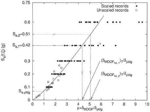
FIGURE 3.26 Predicted maximum nonlinear interstory drift ductility displacements in a five-story steel building frame subjected to recorded accelerograms of various intensities Sa. Recorded accelerograms of various intensity levels, as measured here by the spectral acceleration at the 1-hertz fundamental mode of the structure (in the elastic range), have been used as input to the analyses. The response is measured by a maximum story ductility, the maximum interstory drift (denoted dMDOF) normalized by dyldg, the drift level required to induce yield or the onset of nonlinear behavior. As a point of reference, in central Los Angeles the annual probability of exceeding 0.42g 1-hertz spectral acceleration, which is the intensity measure being used here, is 0.1 percent. If this level of shaking were to occur, the maximum story ductility expected is about 4, implying displacements four times the elastic limit, major damage to nonstructural elements, and permanent distortions or possibly fracture of local beam-column connections in the building. SOURCE: P. Bazzurro, C.A. Cornell, N. Shome, and J.E. Carballo, Three proposals for characterizing MDOF nonlinear seismic response, J. Struct. Engr.,124, 1281-1289, 1998. Reproduced by permission of the American Society of Civil Engineers.
of the Pacific might, by telegraphic communication, receive eighteen to twenty-five hours’ warning of the coming of destructive sea waves resulting from earthquakes in South America.
Based on Milne’s observation that seismic waves propagate much more slowly than electromagnetic waves, single-seismometer warning systems were first deployed in Japan in 1950 to stop trains after earthquakes. New communication and computing technologies have advanced these warning systems over the past 50 years (97). Real-time seismic systems have also been deployed in Taiwan, Mexico, and the United States, involving dedicated digital seismic networks that are automatically analyzed by computers and broadcast to interested users (e.g., emergency service organizations, utilities, train operators). In Mexico, a seismic alert system, operating since 1991, warns of subduction-zone earthquakes several hundred kilometers west of Mexico City. During the September 14, 1995, Guerrero earthquake (M 7.3), its warning arrived 72 seconds before the strong ground motion (98). An early warning system set up by the USGS after the 1989 Loma Prieta earthquake gave workers on the collapsed freeways in Oakland (about 100 kilometers from the rupture zone) as much as 20 seconds’ notification before the shaking from strong aftershocks, allowing them to evacuate hazardous areas (99).
The requirements for a real-time monitoring system are: reliable components that will perform during an earthquake, broad bandwidth communications facilities, and seismic instrumentation with high dynamic range and broad band-recording capabilities. With this approach, real-time systems in the United States are being developed in southern (Caltech USGS Broadcast of Earthquakes) and northern (Rapid Earthquake Data Integration Project) California (100). With partnerships between university researchers, private corporations, and government (federal, state, and local), these systems have largely evolved by upgrading the communications and data-processing infrastructure of existing seismic networks. Significant improvements in the southern California seismic network are currently under way (101).
The recent deployment of high-performance systems in California has motivated an active dialogue regarding operational goals and practices. This has focused attention on the differing data delivery needs before, during, and after the start of ground shaking, the type of information required for different purposes (e.g., simple warning, magnitude, hypocenter, extent and location of strong ground shaking), the tolerance for false alarms, and the policies for broadcasting data. Consideration of these questions has revealed a much broader range of applications for real-time data than originally anticipated. At first, the systems were expected to deliver warnings before strong ground shaking began so that evasive
actions could be taken, such as evacuation, duck-and-cover procedures, and automated shutdown of sensitive facilities. However, collaboration between developers and users of real-time information, together with the experience from the Northridge and Hyogo-ken Nanbu earthquakes, has revealed that real-time broadcasts will still be valuable even if they arrive after the earthquake. For example, hypocenter determinations can be combined with spatial maps of ground shaking and real-time loss modeling to predict the areas of greatest damage before response and rescue teams are deployed.
A key recent development is ShakeMap, which provides maps of observed ground shaking and intensity within a few minutes of an earthquake’s occurrence. This product was developed by the USGS and was originally implemented as part of the Tri-Net seismic network in southern California (102). ShakeMap is now operational in other areas with high seismic risk and relatively dense seismograph coverage, including the San Francisco Bay area, the Puget Sound region, and the Wasatch Front. ShakeMap interpolates between observed ground motions recorded at seismograph sites using empirical ground-motion relations and maps of site conditions. As more dense instrumentation is deployed in urban areas under the Advanced National Seismic System, ShakeMap will be implemented in other areas. ShakeMap is an effective tool for rapidly communicating shaking and intensity information to emergency managers, government officials, the private sector, and the general public. The ShakeMap software can also be linked to HAZUS to provide rapid estimates of losses. From this information, impacts on critical facilities can be estimated quickly, followed by rapid decisions as to response and mitigation strategies for the facility, the occupants, and the community (103).
In detail, the terminology for these efforts shifts from real time or early warning, to rapid ground-motion estimation. However, as the time scales for these data deliveries shrink to within tens of seconds of the events, the distinction between the systems begins to blur. Early estimates of ground shaking (provided as warnings) can be updated with time as more and more stations report the entire history of shaking at their sites, permitting interpolation of the entire network’s direct shaking observations, rather than more primitive, forward ground-motion predictions based only on location and magnitude estimates. Prior and posterior information about the likely effects of local site conditions can be factored in at still later stages.
Utilization of and demand for this rapid information will be user specific, indicating that the costs and benefits of these systems will vary among regions. For example, in postearthquake emergency services, it is more important to know the distribution of strong motion than the rup-
ture initiation point. This motivates a need for data on the center of energy radiation (ground-motion centroid), the conventional hypocenter, and the spatial distribution of ground motion. With these requirements, detection and location algorithms for real-time warning will differ from standard procedures at traditional seismographic stations.
3.6 CLOSING THE IMPLEMENTATION GAP
For the past 25 years, the NEHRP has sponsored a combination of basic and applied research on the causes of earthquakes, their distribution, and their damage to the built environment (Appendix A). The review in this chapter demonstrates that this information is paying off in the ability to anticipate and reduce earthquake destruction. However, the degree to which the knowledge gained through research has been utilized in coordinated programs of risk mitigation has been the focus for criticism of the NEHRP strategy. In a 1995 report to the U.S. Congress, the Office of Technology Assessment stated (104):
NEHRP has made significant contributions toward improving our understanding of earthquakes and strategies to reduce their impact. However, much of the United States remains at risk for significant earthquake losses. Risk-reduction efforts lag far behind the knowledge base created by research; this lag or implementation gap, reflects the limitations of NEHRP’s information-based strategy for encouraging nonfederal action.
Considerable controversy surrounds which types of loss reduction measures should be implemented by government and the private sector through regulatory policies, economic incentives, long-term investments, and public education. Part of the debate concerns the role of scientific research in closing the implementation gap. The key question is: how can researchers participate more effectively in translating the technical understanding of earthquake phenomena into civic actions?
This chapter has explored the great utility of combining seismic hazard analysis with engineering-based performance estimates to produce measures of earthquake risk, in terms of either the damage expected during the lifetime of an individual structure or the annualized economic loss expected for a specified region. Three further steps are necessary to reduce potential losses:
-
Mitigation options must be identified and evaluated. These options include improved building codes, design enhancements, retrofitting, land-use planning, and insurance. Evaluation must include assessments of the cost and effectiveness of each option to reduce risk.
-
The public, elected officials, property owners, and other decision makers must understand the nature of the risks, their mitigation options, and the costs of action and inaction.
-
Mitigation decisions must be made and implemented. Setting priorities for action is imperative, since the need for improvement will always vastly exceed the available resources.
Experience gained during NEHRP demonstrates that a consensus to invest in risk reduction is best achieved through an active collaboration among scientists, engineers, government officials, and business leaders, working together with an informed populace. A corollary is that earthquake research will contribute to risk reduction more effectively when it is carried out in a context that recognizes the problem’s engineering, economic, and political dimensions (105).
An example of a public-private partnership designed to bridge the implementation gap is the lifelines program conducted by the Pacific Gas and Electric Co., Caltrans, the California Energy Commission, and the Pacific Earthquake Engineering Research Center (106). This program identifies and funds research on how to make lifelines less vulnerable to earthquake shaking and follows up this research with steps to implement research findings within the sponsoring organizations.
FEMA’s Project Impact is another notable example. Project Impact fostered public-private partnerships in selected communities to prepare for the occurrence of earthquakes and other natural hazards. In Seattle, for example, Project Impact involved a partnership between local, state, and federal agencies, universities, and the private sector and included programs for seismic retrofit of schools and homes, as well as a disaster mitigation plan for businesses (107). Although Project Impact was terminated as a federal program in 2001, it helped minimize damage and injuries during the February 28, 2001, Nisqually earthquake. As a result, the city of Seattle is continuing the program.
Scientists and engineers have lacked effective organizational and programmatic mechanisms to exploit the synergy between the two fields and to educate each other about implementation issues. The federal government has established an elaborate array of research programs focused on the engineering aspects of earthquake safety, which include three National Science Foundation (NSF) earthquake engineering centers (108), the NSF initiative for a Network for Earthquake Engineering Simulation (NEES) (109), and the NEHRP component of the National Institute of Standards and Technology (Appendix A). The participants have been mainly engineers, with earthquake scientists engaged only on the periphery of these efforts. The USGS and NSF Earth Science Division sponsor large, diverse programs in basic and applied earthquake research, includ-
ing major centers to promote interdisciplinary collaborations and deliver new products for seismic hazard analysis (110). The primary participants in these programs have been geoscientists, with engineers relegated to a relatively minor role. The Federal Emergency Management Agency leads NEHRP and holds the federal responsibility for seismic risk mitigation. Although FEMA is deeply involved in both risk assessment and emergency management, it is primarily a user, not a coordinator, of earthquake research. At present, no agency or organization is responsible for ensuring an integrated approach to earthquake science and engineering. This vacuum could be filled through structured collaborations between the science and engineering research centers, explicitly funded and frequently reviewed by NEHRP agencies. These collaborations should involve economists and social scientists with expertise in mitigation issues.
Scientists also need better organizational and technological support for communicating with all levels of society about earthquake hazards, mitigation measures, and the appropriate use of earthquake information. The challenges are to select the right kinds of educational activities, target the appropriate audiences, and present them at the right places and times. Appropriately, NEHRP agencies are now placing more emphasis on efforts to interpret scientific research and reduce the results to understandable, usable products. Even if well-packaged, however, such products cannot be “simply thrown over the wall” for public consumption. Effective communication between researchers and end users requires a two-way, continuing dialogue with repeated opportunities for the exchange of ideas and plans. Likewise, effective public education requires interactive mechanisms that can engage an audience at an appropriate level. The new technologies of the Internet—interactive web pages backed by powerful, simple-to-use query languages and digital libraries with up-to-the-minute earthquake information—offer considerable promise. However, their utilization will depend on support structures with more financial and human resources than a typical research group.
NOTES
|
1. |
As described in Section 1.2, the warning times for destructive tsunamis that cross wide ocean basins can be several hours or more. |
|
2. |
Secondary hazards also include fires, dispersal of nuclear materials, and other threats indigenous to the built environment. |
|
3. |
The displacement across the fault scales with the cube root of seismic moment for earthquakes of magnitude less than about 6.5 and with the square root of moment for larger events. |
|
4. |
A complete discussion of these complexities is given in R.S. Yeats, K. Sieh, and C.R. Allen, The Geology of Earthquakes, Oxford, New York, 568 pp., 1997. |
|
5. |
Throughout the engineering literature, the redundant term “time history” is used to describe ground motion as a function of time and is thus synonymous with seismogram, |
|
|
accelerogram, and seismic waveform. The spectral response method is described in Section 2.7. |
|
6. |
N.A. Abrahamson and P.G. Somerville, Effects of the hanging wall and foot wall on ground motions recorded during the Northridge earthquake, Bull. Seis. Soc. Am., 86, S93-S99, 1996. |
|
7. |
See summary of ground motion models described by N.A. Abrahamson and K.M. Shedlock (Overview of ground motion attenuation models, Seis. Res. Lett., 68, 9-23, 1997). |
|
8. |
E.H. Field and the SCEC Phase III Working Group, Accounting for site effects in probabilistic seismic hazard analyses of Southern California: Overview of the SCEC Phase III report, Bull. Seis. Soc. Am., 90, S1-S31, 2000. This major study of regional attenuation relations and local site effects concluded that “any model that attempts to predict ground motion with only a few parameters will have substantial intrinsic variability. Our best hope for reducing such uncertainties is via waveform modeling based on the first principles of physics.” |
|
9. |
P.G. Somerville and J. Yoshimura, The influence of critical Moho reflections on strong ground motions recorded in San Francisco and Oakland during the 1989 Loma Prieta earthquake, Geophys. Res. Lett.17, 1203-1206, 1990. The ground motions recorded in San Francisco and Oakland were actually stronger than those for some closer sites with similar geology. |
|
10. |
S.K. Singh, E. Mena, and R. Castro, Some aspects of source characteristics of the 19 September 1985 Michoacan earthquake and ground motion amplification in and near Mexico City from strong motion data, Bull. Seis. Soc. Am., 78, 451-477, 1988. |
|
11. |
See S. Gao, H. Liu, P.M. Davis, and L. Knopoff (Localized amplification of seismic waves and correlation with damage due to the Northridge earthquake: Evidence for focusing in Santa Monica, Bull. Seis. Soc. Am., 86, S209-S230, 1996) for an example of focusing during the 1994 Northridge earthquake. |
|
12. |
H.B. Seed and I.M. Idriss, Analyses of ground motions at Union bay, Seattle during earthquakes and distant nuclear blasts, Bull. Seis. Soc. Am.,60, 125-136, 1970; M. Zeghal and A.-W. Elgamal, Analysis of site liquefaction using earthquake records, J. Geotech. Engr.,120, 996-1017, 1994; E.H. Field, P.A. Johnson, I.A. Beresnev, and Y.H. Zeng, Nonlinear ground-motion amplification by sediments during the 1994 Northridge earthquake, Nature,390, 599-602, 1997; J. Aguirre and K. Irikura, Nonlinearity, liquefaction and velocity variation, of soft soil layers in Port Island, Kobe, during the Hyogo-ken Nanbu earthquake, Bull. Seis. Soc. Am., 87, 1244-1258, 1997. |
|
13. |
NEHRP site classifications are rated on a five-level scale ranging from A (hard rock with measured shear-wave velocity [vS] more than 5000 feet per second) to E (soft soil with vS less than 600 feet per second); see Building Seismic Safety Council, 1997 Edition NEHRP Recommended Provisions for Seismic Regulations for New Buildings and Other Structures, FEMA 302/303, Part 1 (Provisions) and Part 2 (Commentary), developed for the Federal Emergency Management Agency, Washington, D.C., 337 pp., 1998. |
|
14. |
Some have argued (W.D.L. Finn, Geotechnical engineering aspects of microzonation, in Proceedings of the Fourth International Conference on Seismic Zonation, August 25-29, 1991, Stanford, California, Vol. I, pp. 199-259, 1991; K. Aki, Local site effects on weak and strong ground motion, Tectonophysics, 218, 93-111, 1993) that a very low but approximately constant shear modulus and site resonance at Mexico City can explain the ground motions without appeal to nonlinear effects. Others (S.K.E. Singh, E. Mena, and R. Castro, Some aspects of source characteristics of the 19 September 1985 Michoacan earthquake and ground motion amplification in and near Mexico City from strong motion data, Bull. Seis. Soc. Am., 78, 451-477, 1988; C. Lomnitz, Mexico 1985; The case for gravity waves, Geophys. J. Int., 102, 569-572, 1990) argue for a strong nonlinear shear modulus reduction during the strong shaking. Recent efforts to measure dynamic strains at depth in the Valley of Mexico from |
|
|
Nicaragua earthquake, which caused a destructive 10-meter runup on the Nicaraguan coast, and those such as the 1896 Sanriku and 1946 Unimak Islands earthquakes, which may have involved large-scale slumping. Another type of tsunami source is exemplified by the 1883 Krakatau eruption in Indonesia, which inundated 165 coastal villages and killed more than 30,000. |
|
27. |
T.Y. Wu, Long waves in ocean and coastal waters, J. Engr. Mech. Div., 107, 501-521, 1981; P.L.F. Liu and J. Earickson, A numerical model for tsunami generation and propagation, in Tsunamis: Their Science and Engineering, J. Iida and T. Iwasaki, eds., Proceedings of the International Tsunami Symposium, Sendai-Ofunato-Kamaishi, Japan, May 1981, Terra Scientific Publ., Tokyo, pp. 227-240, 1983; M. Shibata, One-dimensional dispersive deformation of tsunami with typical initial profiles on continental topographies, in Tsunamis: Their Science and Engineering, J. Iida and T. Iwasaki, eds., Proceedings of the International Tsunami Symposium, Sendai-Ofunato-Kamaishi, Japan, May 1981, Terra Scientific Publ., Tokyo, pp. 241-250, 1983. |
|
28. |
M.J. Briggs, C.E. Synolakis, G.S. Harkins, and D.R. Green, Laboratory experiments of tsunami runups on a circular island, Pure Appl. Geophys., 144, 569-593, 1995; S. Tinti, and C. Vannini, Tsunami trapping near circular islands, Pure Appl. Geophys., 144, 595-619, 1995. |
|
29. |
P.L.F. Liu, C. Synolakis, and H.H. Yeh, Impressions from the first international workshop on long wave runup, J. Fluid Mech., 229, 675-688, 1991; H.H. Yeh, Tsunami bore runup, Natural Hazards, 4, 209-220, 1991; S. Tadepalli and C.E. Synolakis, Model for the leading waves of tsunamis, Phys. Rev. Lett., 77, 2141-2154, 1996. |
|
30. |
E.P. Myers and A.M. Baptista, Finite element modeling of the July 12, 1993 Hokkaido Nansei-Oki tsunami, Pure Appl. Geophys., 144, 769-802, 1995; P.L.F. Liu, Y.S. Cho, S.B. Yoon, and S.N. Seo, Numerical simulations of the 1960 Chilean tsunami propagation and inundation at Hilo, Hawaii, in Tsunami: Progress in Prediction, Disaster Prevention and Warning, Y. Tsuchiya and N. Shuto, eds., Kluwer Academic Publishers, Dordrecht, The Netherlands, pp. 99-115, 1995. |
|
31. |
G.F. Carrier, On-shelf tsunami generation and coastal propagation, in Tsunami: Progress in Prediction, Disaster Prevention and Warning, Y. Tsuchiya and N. Shuto, eds., Kluwer Academic Publishers, Dordrecht, The Netherlands, pp. 1-20, 1995. |
|
32. |
F.I. Gonzalez, K. Satake, E.F. Boss, and H.O. Mofjeld, Edge wave and non-trapped modes of the 25 April 1992 Cape Mendocino tsunami, Pure Appl. Geophys., 144, 409-426, 1995. |
|
33. |
A. Frankel, C. Mueller, T. Barnhard, D. Perkins, E. Leyendecker, N. Dickman, S. Hanson, and M. Hopper, National Seismic-Hazard Maps: Documentation June 1996, U.S. Geological Survey Open-File Report 96-532, USGS Federal Center, Denver, Colo., 111 pp, 1996; A. Frankel, C. Mueller, T. Barnhard, D. Perkins, E. Leyendecker, N. Dickman, S. Hanson, and M. Hopper, Seismic-Hazard Maps for the Conterminous United States, U.S. Geological Survey Open File Report 97-131, USGS Federal Center, Denver, Colo., 12 maps, 1997; A. Frankel, C. Mueller, T. Barnhard, D. Perkins, E. Leyendecker, N. Dickman, S. Hanson, and M. Hopper, Seismic-Hazard Maps for California, Nevada, Western Arizona/Utah, U.S. Geological Survey Open-File Report 97-130, USGS Federal Center, Denver, Colo., 12 maps, 1997. The maps and their documentation can be downloaded from <http://geohazards.cr.usgs.gov/eq/>. |
|
34. |
The probability of exceedance in 50 years PE50 is related to the mean return period TR by the equation PE50 = 1 – (1 – 1/TR)50, so that the probabilities of PE50 = 2, 5, and 10 percent used in the national seismic hazard maps correspond to TR ˜ 2475, 975, and 475 years. The annual probabilities of exceedance are 1/TR ˜ 0.04 percent, 0.1 percent, and 0.2 percent, respectively. |
|
35. |
In Guidelines for the Seismic Rehabilitation of Buildings (Building Seismic Safety Council and Applied Technology Council, FEMA Report 273, Washington, D.C., 400 pp., Octo- |
|
|
ber, 1997), the level of shaking defined by PE50 = 10 percent is called Basic Safety Earthquake 1 (BSE-1) ground motion, and the level of shaking defined by PE50 = 2 percent is called BSE-2 ground motion. In the NEHRP Recommended Provisions for Seismic Regulations for New Buildings and Other Structures (Building Seismic Safety Council, FEMA Report 368, Washington, D.C., 374 pp., March 2001), the PE50 = 2 percent shaking level is called the Maximum Considered Earthquake. Other hazard levels are routinely employed; for example, the California Seismic Safety Commission defines a “likely earthquake” by PE50 = 40 percent (about a 100-year return period) to represent the intensity likely to be experienced one or more times during a facility’s lifetime, and an “upper-bound earthquake” by PE50 = 5 percent (975-year return period) to represent the most severe shaking that could ever occur (EQE International, Earthquake Risk Management: A Toolkit for Decision-Makers, California Seismic Safety Commission Report 99-04, Sacramento, Calif., 185 pp., 1999). |
|
36. |
R.K. McGuire, Probabilistic seismic hazard analysis and design earthquakes: Closing the loop, Bull. Seis. Soc. Am., 85, 1275-1284, 1995; S. Harmsen, D. Perkins, and A. Frankel, Deaggregated magnitudes and distances for probabilistic ground motions in the central and eastern U.S., Bull. Seis. Soc. Am., 89, 1-13, 1999; P. Bazzurro and C.A. Cornell, Disaggregation of seismic hazard, Bull. Seis. Soc. Am., 89, 501-520, 1999. Disaggregation tables for 100 U.S. cities can be downloaded from <http://geohazards.cr.usgs.gov/eq.> |
|
37. |
Working Group on California Earthquake Probabilities, Earthquake Probabilities in the San Francisco Bay Region, U.S. Geological Survey Open-File Report 99-517, Reston, Va., 46 pp., 1999. |
|
38. |
R. Bürgmann, D. Schmidt, R.M. Nadeau, M. d’Alessio, E. Fielding, D. Manaker, T.V. McEvilly, and M.H. Murray, Earthquake potential along the northern Hayward fault, California, Science, 289, 1178-1182, 2000. |
|
39. |
T.L. Davis and J.S. Namson, A balanced cross-section of the 1994 Northridge earthquake, southern California, Nature, 372, 167-169, 1994. |
|
40. |
Working Group on California Earthquake Probabilities, Seismic hazards in southern California: Probable earthquake 1994 to 2024, Bull. Seis. Soc. Am., 85, 379-439, 1995 (SCEC Phase II report). |
|
41. |
T.H. Dixon, M. Miller, F. Farina, H. Wang, and D. Johnson, Present-day motion of the Sierra Nevada block and some tectonic implications for the Basin and Range Province, North American Cordillera, Tectonics, 19, 1-24, 2000; G. Peltzer, F. Crampé, S. Hensley, and P. Rosen, Transient strain accumulation and fault interaction in the eastern California shear zone, Geol. Soc. Am., 29, 975-978, 2001. |
|
42. |
The case for great Chilean-type earthquakes in the Cascadian subduction zone was made by T.H. Heaton and H. Kanamori (Seismic potential associated with subduction in the northwestern United States, Bull. Seis. Soc. Am., 74, 933-941, 1984) based in part on previous geodetic observations by J.C. Savage, M. Lisowski, and W.H. Prescott (Geodetic strain measurements in Washington, J. Geophys. Res., 86, 4929-4940, 1981). Paleoseismic data supporting this hypothesis were first presented by B.F. Atwater (Evidence for great Holocene earthquakes along the outer coast of Washington State, Science, 236, 942-944, 1987). |
|
43. |
B.F. Atwater, Geologic evidence for earthquakes during the past 2000 years along the Copalis River, southern coastal Washington State, J. Geophys. Res.,97, 1901-1919, 1992; D.K. Yamaguchi, B.F. Atwater, D.E. Bunker, B.E. Benson, and M.S. Reid, Tree-ring dating the 1700 Cascadia earthquake, Nature, 389, 922-923, 1997, correction in Nature, 390, 352, 1997. |
|
44. |
K. Satake, K. Shimazaki, Y. Tsuji, and K. Ueda, Time and size of a giant earthquake in Cascadia inferred from Japanese tsunami records of January 1700, Nature,379, 246-249, 1996. |
|
45. |
R.C. Bucknam, E. Hemphill-Haley, and E.B. Leopold, Abrupt uplift within the past 1,700 years at southern Puget Sound, Washington, Science, 258, 1611-1614, 1992; B.F. Atwater |
|
77. |
M.N. Machette and J.R. Bowman, Episodic nature of earthquake activity in stable continental regions revealed by paleoseismicity studies of Australian and North American Quaternary faults, Austr. J. Earth Sci., 44, 203-214, 1997. |
|
78. |
Proprietary software packages for loss estimation were first developed in the private sector. An example was the Early Post-Earthquake Damage Assessment Tool (EPEDAT) developed by EQE International, Inc., which applies intensity-damage relationships over specified zip codes. EPEDAT was developed for the California Office of Emergency Services and has been customized for five southern California counties (Los Angeles, Orange, Riverside, San Bernardino, and Ventura). HAZUS, developed by FEMA, uses PGA, PGV, Sa, and Sv inputs and building capacity-pushover analysis for census tracts. |
|
79. |
HAZUS was developed by a consortium of university and private sector researchers and is maintained through NIBS. Its trial release in 1994 was followed by extensive efforts to collect input data for the software, to refine the algorithms for calculating damage, to educate state and local planning officials about the need for accurate information to support loss modeling, and to validate the methodology against well-characterized earthquakes. The final report on the methodology was delivered in fall 1997. The currently released version is HAZUS ®99, SR2, available at <http://www.fema.gov/hazus>, and further improvements are continuing. |
|
80. |
See <www.hazus.org>. |
|
81. |
The user should also have a good technical understanding of seismic hazards and the earthquake vulnerability of the modeled facilities to create realistic representations of the urban inventory and its fragilities, as well as the geologic hazards. The default data for some of these inputs, which a less skilled user might be tempted to employ, are crude and can lead to unrealistic loss estimates. |
|
82. |
Western U.S. earthquakes resulting in loss of life were the 1987 Whittier Narrows (M 5.9, 8 deaths), 1989 Loma Prieta (M 7.0, 63 deaths), 1992 Landers (M 7.3, 1 death), and 1994 Northridge (M 6.7, 57 deaths). Other severe earthquakes with no loss of life were 1983 Coalinga (M 6.5), 1992 Petrolia (M 6.9), 1999 Hector Mine (M 7.1), and 2001 Nisqually (M 6.8). |
|
83. |
A worldwide total of 160,000 is a lower bound from conservative USGS estimates for the 21 earthquakes resulting in more than 1000 deaths each that occurred from October 1983 to January 2001. See <http://neic.usgs.gov/neis/eqlists/eqsmajr.html>. |
|
84. |
The BSSC (<http://www.bssconline.org>) is an independent, voluntary membership body representing a wide variety of building community interests. It was established in 1979 under the auspices of the NIBS to enhance public safety by providing a national forum to foster improved seismic safety provisions for use by the building community in the planning, design, construction, regulation, and utilization of buildings. The BSSC promotes the development and adoption of seismic safety provisions in building codes suitable for use throughout the United States. |
|
85. |
The ATC (<http://www.atcouncil.org>) is a nonprofit, tax-exempt corporation established in 1971 through the efforts of the Structural Engineers Association of California. Its mission is to develop state-of-the-art, user-friendly engineering resources and applications for use in mitigating the effects of natural and other hazards on the built environment. ATC also identifies and encourages needed research and develops consensus opinions on structural engineering issues in a nonproprietary format. ATC is guided by a Board of Directors consisting of representatives appointed by the American Society of Civil Engineers, the Structural Engineers Association of California, the Western States Council of Structural Engineers Associations, and four at-large representatives concerned with the practice of structural engineering. Funding for ATC projects is obtained from government agencies and from the private sector in the form of tax-deductible contributions. |
|
86. |
The Earthquake Engineering Research Institute (<http://www.eeri.org>) was founded in 1949 as an outgrowth of the Advisory Committee on Engineering Seismology of the U.S. Coast and Geodetic Survey. A founding purpose of the institute was to encourage research in the field of earthquake engineering. It is a national, nonprofit, technical society of engineers, geoscientists, architects, planners, public officials, and social scientists with the mission of advancing the science and practice of earthquake engineering and the solution of national earthquake engineering problems to protect people and property from the effects of earthquakes. |
|
87. |
The American Society of Civil Engineers (<http://www.asce.org/>) is a not-for-profit organization actively involved in developing seismic standards and codes. |
|
88. |
J.E. Bevers, ed., Theme issue: Seismic isolation, Earthquake Spectra, 6, 161-430, 1999. |
|
89. |
R.D. Hanson, ed., Theme issue: Passive energy dissipation, Earthquake Spectra, 9, 319-641, 1993; R.D. Hanson and T.T. Soong, Seismic Design with Supplemental Energy Dissipation Devices, Earthquake Engineering Research Institute, Monograph MNO-8, Oakland, Calif., 135 pp., 2001. |
|
90. |
T.T. Soong and M.C. Constantinou, eds., Passive and Active Structural Vibration Control in Civil Engineering, Springer-Verlag, Vienna, 380 pp., 1994. |
|
91. |
The quote is from Seismology Committee, Recommended Lateral Force Requirements— Commentary, Structural Engineers Association of California, Sacramento, 203 pp., 1990. |
|
92. |
Guidelines for the Seismic Rehabilitation of Buildings (Building Seismic Safety Council and Applied Technology Council, Federal Emergency Management Agency Report FEMA-273, Washington, D.C., 400 pp., October, 1997). Important precursors were two reports published soon after the Northridge earthquake, Performance Based Seismic Engineering of Buildings (Vision 2000 Committee, J. Soulanges, ed., Structural Engineers Association of California, Sacramento, 2 vols., 115 pp., 1995) and Guidelines for the Seismic Rehabilitation of Buildings (Building Seismic Safety Council and Applied Technology Council, Federal Emergency Management Agency Report FEMA-273, Washington, D.C., 400 pp., October, 1997). |
|
93. |
SAC Joint Venture, Recommended Seismic Design Guidelines for New Steel Moment-Frame Buildings, FEMA 350, U.S. Government Printing Office: Washington, D.C., 207 pp., 2000. |
|
94. |
K. Olsen, Site amplification in the Los Angeles Basin from three-dimensional modeling of ground motion Bull. Seis. Soc. Am., 90, S77-S94, 2000. |
|
95. |
A. Cornell and H. Krawinkler, Progress and challenges in seismic performance assessment, Pacific Earthquake Engineering Research Center, PEER Center News, 3, 1-3, 2000. |
|
96. |
J. Milne, Earthquakes and Other Earth Movements, D. Appelton and Company, New York, p. 304, 1886. |
|
97. |
National Research Council, Real-Time Earthquake Monitoring, National Academy Press, Washington, D.C., 52 pp., 1991. See also H. Kanamori, E. Hauksson, and T.H. Heaton, Real-time seismology and hazard mitigation, Nature, 390, 461-464, 1997. |
|
98. |
J.M. Espinosa Aranada, A. Jiménez, G. Ibarrola, F. Alcantar, A. Aguilar, M. Inostroza, and S. Maldanado, Mexico City seismic alert system, Seis. Res. Lett., 66, 42-53, 1995. |
|
99. |
W.H. Bakun, F.G. Fischer, E.G. Jensen, and J. VanSchaack, Early warning system for foreshocks, Bull. Seis. Soc. Am., 84, 359-365, 1994. |
|
100. |
In California, warning systems were first used to alert rescue workers about aftershocks following the Loma Prieta earthquake. |
|
101. |
The centerpiece of this upgrade is the new installation of the TriNet network of 170 broadband sensors and 700 strong-motion instruments in southern California. The operational goal is that the system will detect all events to M > 1.8 and that all of the data will be available in real time for hazard mitigation purposes. |
|
102. |
D.J. Wald, V. Quitoriano, T.H. Heaton, H. Kanamori, C.W. Scrivener, and B. Worden, Trinet “shakemaps”: Rapid generation of peak ground motion and intensity maps for earthquakes in Southern California, Earthquake Spectra, 15, 537-555, 1998. |
|
103. |
Such capabilities could be of great value following an earthquake when communication and transportation are difficult. Examples include improved coordination of the response of firefighting and medical efforts, as well as routing and prioritizing the overload of telephone calls in the critical hours after an earthquake. |
|
104. |
Office of Technology Assessment, Reducing Earthquake Losses, OTA-ETI-623, U.S. Government Printing Office, Washington, D.C., 162 pp., 1995. |
|
105. |
One example of this holistic approach to hazard mitigation is the Natural Hazards Center of the University of Colorado, which is a national clearinghouse for information on natural hazards mitigation, with emphasis on social and political aspects (<www.colorado.edu/hazards>). |
|
106. |
|
|
107. |
|
|
108. |
The NSF Directorate of Engineering funds the Pacific Earthquake Engineering Research Center (<http://peer.berkeley.edu/>), the Multidisciplinary Center for Earthquake Engineering Research (<http://mceer.buffalo.edu/>), and the Mid-America Earthquake Center (<http://mae.ce.uiuc.edu/>). |
|
109. |
NEES will provide real-time remote access to a complete set of testing and experimental facilities, making them widely available to earthquake engineers. The on-line network, or “collaboratory,” will furnish researchers across the country with shared-use access to advanced equipment, databases, and computer modeling and simulation tools (<http://www.eng.nsf.gov/nees/>). |
|
110. |
The NSF and USGS sponsor the Southern California Earthquake Center, which involves 40 universities, government laboratories, and other public and private research organizations. The USGS also maintains major centers for earthquake research in Menlo Park, California, and Golden, Colorado. |


