
NATURAL DISASTERS ROUNDTABLE
FORUM ON SEA LEVEL RISE AND COASTAL DISASTERS
INTRODUCTION
The Natural Disasters Roundtable1 (NDR), formed by the National Academies in 2000, held its third public forum on October 25, 2001 at the National Academy of Sciences Building in Washington, D.C. The topic of this forum was sea level rise and coastal disasters—a session intended to exchange information and stimulate discussion concerning the interconnections associated with sea level rise and coastal disasters. Although some attention has been paid to the phenomena of sea level rise, the critical role that sea level rise plays in association with coastal storms in causing natural disasters is not often discussed. This objective of this forum was not only to demonstrate the relationship between sea level rise and coastal disasters but also to discuss possible mitigation measures to prevent large-scale coastal disasters from occurring.
Sea level is rising at an approximate rate of 2 mm/year 2 (Douglas et al., 2001) and is expected to accelerate over the next 100 years (USGCRP, 2001). Although scientists are not in total agreement on the rate of rise or acceleration, the fact that it is rising is unquestionable. The impacts of sea level rise include beach erosion, inundation of low lying areas, salt water intrusion into aquifers, and increased flooding. These issues are important to the entire world, as its population is increasingly moving toward the coast—about 60 percent (~3.6 billion) of the world’s population lives within 60 kilometers (37 miles) of the coast (UNESCO, 1998). Low-lying populated areas, such as cities built on deltas (see figure 1) are most vulnerable to rising sea levels.
To address science and policy issues associated with the combined problems of sea level rise and coastal disasters, the NDR steering committee selected an interdisciplinary group of speakers and panelists (See Appendix A for the agenda, Appendix C for speakers bios). The discussion focused largely on North America but also included a presentation on the problems of Venice, Italy. As a one-day meeting, the forum sought to identify a number of key issues for science and policy, which may be addressed in more comprehensive studies in the future. Approximately 100 people participated in this forum (See Appendix B for a list of attendees).
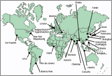
FIGURE 1 Very vulnerable areas of the World (Populated Deltas) Source: SURVAS, 2002 (http://www.survas.mdx.ac.uk/backgrou.htm).
SEA LEVEL RISE: THE SCIENCE AND THE SITUATION
Sea level rise is one of the most apparent and widespread consequences of climate change. The thermal expansion of the world’s water bodies and the melting of glaciers is a slow, but pernicious process. In fact, it has taken over a century for average sea level to rise 18 cm (Douglas et al., 2001). Along the U.S. East Coast an average of 12 cm of subsidence is added to the 18cm of rise making the relative sea level rise about 30.5 cm (or 1 foot) per century. The impacts of this rise have been demonstrable including beach erosion and loss of salt marshes. In the next 100 years, the rate of this eustatic rise is expected to increase by 0.44 (8cm/18cm) to 4.9(88cm/18cm) (IPCC, 2001). Table 1 shows a comparison of prediction data for absolute sea level rise and rate using IPCC data from 1995 and 2001.
Table 1. Prediction Data for Sea Level Rise and Rate for Time Period 1990 to 2100
|
Date of IPCC Prediction |
IPCC Sea Level Rise Ranges (in cm) |
IPCC Mid Range Estimate (in cm) |
Ratio of Column 3 to 1 foot per Century |
|
1995 |
15-95 |
50 |
0.45-2.83 |
|
2001 |
8-88 |
49 |
0.24-2.62 |
|
SOURCE: Data from IPCC (1996, 2001). |
|||
The forum began with an introductory presentation by Stephen Leatherman of Florida International University. Small changes in sea level can have significant consequences, including inundation of low-lying areas, erosion of beaches and bluffs, loss of coastal wetlands, and increased flooding and storm damage. Slowly rising sea level is a problem with a long lead-time so that the consequences are not always readily apparent. Frequently, the impacts are storm generated as bulkheads and sea walls are overcome and fail during high-energy conditions. For example, the December 11-12, 1992 nor’easter caused anomalous high water levels of 8.5 feet. If these levels had been several feet higher extensive flooding of critical train and transportation tunnels with possible loss of life would have resulted. The protective dikes were built over a hundred years ago and had not been adjusted upward to reflect present higher sea level so these sea defenses were overtopped by this winter storm.
Rising sea level causes sandy beaches to retreat. There is a large multiplicative effect: one vertical unit of higher water level results in an average of 100 units of horizontal retreat (Douglas et al, 2001). Rising sea level is the underlying driver of shorelines, but there is no energy implicit in raising the water level. Coastal storms accomplish the geologic work of reestablishing the equilibrium profile, which results in the seaward transfer of sand and attendant erosion of beaches and dunes. Over a period of decades, beaches slowly retreat and dunes narrow unless large quantities of sand are added naturally from rivers or artificially through beach nourishment. Few rivers supply sand to the outer coast, and beach nourishment is an expensive and never-ending commitment. Beach erosion problems can also be greatly exacerbated locally by natural inlet dynamics or coastal engineering structures such as groins or jetties. According to a Heinz Center report published in 2000, over the next 60 years, erosion alone may claim one out of four houses within 500 feet of the U.S. shoreline without coastal engineering projects. Flood insurance maps do not inform current or prospective coastal property owners of erosion risks (Heinz Center, 2000).
The Roundtable theme of sea level rise and coastal disasters was well illustrated by the impact of Hurricane Hugo in the Charleston, South Carolina area on September 22, 1989. A nearby barrier island, Folly Island, had a long-term erosion problem in response to slow rising sea level in concert with frequent but moderate winter storms. More significantly, the Charleston entrance jetties blocked the longshore transport of sediment, effectively sand starving this barrier island. The beaches had retreated hundreds of feet so that houses were now close to the high-energy surf. A local favorite seafood restaurant, the Atlantic House, stood in the ocean on pilings during normal tide with a long ramp from the parking lot over the active beach face providing the only access to this business establishment. Leatherman noted that he attended the Coastal Zone 89 meeting in Charleston during the summer of 1989 and enjoyed a delicious meal on this once land-built but now sea-stranded restaurant. His comment to other conference participants was that this facility was a sitting duck for another major storm due to its risky shoreline location. Just a few months later, Hugo, a category IV hurricane, struck the South Carolina coast, and the Atlantic House Restaurant was predictably destroyed—it was so vulnerable due to years of incessant beach erosion that even a “baby Hugo” could have knocked it over. The public and media attention was focused on the “event”—the hurricane that had ravaged the area, causing so much coastal destruction—with little to no recognition of the process—slowly rising sea level and the long-term coastal recession.
Bruce C. Douglas of Florida International University discussed the science and the measurement of sea level rise. Worldwide sea level has risen about 20 cm (~7.87 inches) in the last century based on tide gauge measurements. However, it has not been possible to detect any recent increase (acceleration) in the rate because of the high noise-to-signal ratio during this period of instrumental record (e.g., sea levels fluctuate widely because of storms and other factors so that while the trend of rising water can be clearly detected, acceleration cannot be statistically proven). New monitoring technologies, such as satellite altimeters, are far better than tide gauges for measuring global sea level rise. The “scatter” of 10-day estimates of global sea level from Topex/Poseidon is less than 10 mm RMS while individual tide gauges have a noise level for annual means of about 30-50 mm RMS. In addition, detection of change in the rate of rise using tide gauges takes a longer (decades) time compared to using satellite altimetry. Topex/Poseidon gives near global coverage every 10 days, in sharp contrast to the geographic distribution of tide gauges. The latter need 60 or more years of data to get an estimate of global sea level trends with a formal uncertainty of a few
tenths of a mm per year. Airborne laser monitoring also has great promise, particularly in providing the high-resolution (e.g. 1 foot contour) maps needed to evaluate the impact of increased sea levels. This technology, which is thoroughly proven, is extremely valuable for flood plain and coastal mapping, and detecting changes in polar ice elevation.
It is important to consider the behavior of the land in measuring rates of sea level rise. Some coastal areas experience subsidence whereas other areas experience uplift, which can result in a decrease in relative sea level. Venice, for example, has pumped out so much groundwater over time that it has subsided substantially and the uplift at Juneau, Alaska has resulted in a decrease in relative sea level of 42 cm over the last century (NRC, 1987).
Court Stevenson of the University of Maryland illustrated that in addition to impacts on manmade structures, sea level rise also causes significant ecological changes. Ecological collapse of tidal wetlands occurs when marsh grasses cannot accrete fast enough to keep abreast of rising sea level in locations where inorganic sediment inputs are low. Eventually plant productivity decreases because excessive submergence effectively drains carbon reserves thereby reducing peat formation and marshes are converted to unvegetated mudflats. Moreover, rise in ambient temperature, in part from global warming, reduces oxygen concentrations in the water column of eroded marsh embayments rendering them poor habitat for most fish species. In the case of Blackwater Marsh, once the most extensive marsh area of Chesapeake Bay, 2,300 hectares were lost to open water from 1938 to 1979 resulting in an export of >719,000 metric tons of organic sediment per year to surrounding waters (Stevenson et al., 1985). The loss of fringe marshes, furthermore, drives up the amount of nitrate in groundwater entering the Bay, by reducing the denitrification at the land/sea interface. Thus marsh losses and erosion will make the nutrient cleanup of Chesapeake Bay all the more difficult in the future.
Furthermore, highly organic sediment resulting from eroding tidal marshes presents problems for submerged aquatic vegetation (SAV) downstream. As sea level rise advanced rapidly in the 1990s (> 1cm (.4 inch) per year representing a transitional rate) SAV beds in the center of the Bay also declined, in part due to increased sedimentation from nearby marshes. Thus sea level rise appears to have had a deleterious effect on crab habitat, and thus the crabbing industry, in Chesapeake Bay. Massive marsh collapse and erosion has also been documented in Delaware Bay and other parts of the Mid-Atlantic coastline where incoming sediment supplies are limited and sea level rise is significant (Kearney et al., 2002). Other marsh systems of the world which will suffer as sea level rises include the Mississippi River Delta in Louisiana and the Venice Lagoon in Italy which have witnessed diversions of riverine sediments sent out to sea. Only wetlands that have luxuriant supplies of sediment, from large incoming rivers such as the Ganges and Brahmaputra Rivers in the Bangladesh Delta, can be expected to be resilient over the next century to rising sea level. However, recent schemes in Bangladesh to reclaim low lying land via dikes could starve these low lying lands of sediment nourishment and cause this area to have similar problems as previously documented in Venice.
SEA LEVEL RISE AND COASTAL HAZARDS: ON A COLLISION COURSE WITH DISASTER
The slow creeping up of the sea, coupled with land subsidence and erosion has made some areas of the world especially vulnerable to natural disasters—though not all coastal zones are equally vulnerable. Venice and New Orleans are obvious examples of low-lying (below sea level) coastal areas in which small increases of sea level have had substantial impacts (Leatherman and Burkett, 2002). Barrier islands also are experiencing the significant impacts of sea level rise, such as the Outer Banks of North Carolina.
NEW ORLEANS
Virginia Burkett of the U.S. Geological Survey presented a case study on New Orleans, Louisiana (Burkett et al., In Press). New Orleans is a city built on the delta of the Mississippi River in southern Louisiana, which today is mostly below sea level. It suffers the effects of both sea level rise and land subsidence. The city is located on the Mississippi River deltaic plain, which is subsiding naturally due to sediment dewatering and compaction. New Orleans tapped its artesian aquifers for groundwater supplies, which led to land surface subsidence in several parts of the city. The drainage of organic soils for development has caused a decomposition of soils and compaction, which increases vulnerability to coastal flooding. Moreover, the weight of buildings, levees, roads and other developments has added to compaction and subsidence. New Orleans has deteriorating coastal defenses and huge evacuation challenges because it is surrounded by water and wetlands. The State of Louisiana has lost about one-third of its barrier islands since 1880 and it continues to lose more coastal wetlands each year than the rest of the United States. Precipitation trends, the warming of the atmosphere, and the hydrologic cycle all play a part in wetlands deterioration. The intensification of the global hydrologic cycle will likely lead to higher average annual precipitation, more intense hurricanes, higher wave and storm surge, and more frequent heavy rainfall events.
New Orleans’ defenses against sea level rise and coastal disasters consist of a levee and flood control system designed to absorb a category III hurricane’s storm surge (winds 111-130 mph/storm surge 9-12 feet above normal), 22 mammoth pump stations around the city to pump out rainfall and/or encroaching waters, and coastal wetland system. These defenses come with a price. It would cost roughly $100 million to raise New Orleans’s levees one foot, of which the city would be required to pay $30 million (Leatherman and Burkett, 2002). Louisiana represents 20% of claims each year in the National Flood Insurance Program (NFIP). With about $580 million in claims each year, no state receives a greater share of NFIP annual payouts than Louisiana. Dr. Burkett suggests that in order to adapt, levees and drainage could be scaled up for a category IV or V hurricane, considering historical and projected rates of subsidence, rainfall, and sea level rise.
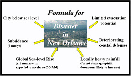
FIGURE 2 There are many aspects of New Orleans that make it vulnerable to coastal disasters. The diagram was presented by Virginia Burkett at the Sea Level Rise and Coastal Disasters Forum on Oct. 25.
VENICE
Rafael L. Bras of the Massachusetts Institute of Technology presented a case study on Venice, Italy. Venice is an engineered system that was built on marshlands in a large lagoon. Occupation of the Venice lagoon area dates back as far as the 6th and 7th centuries. By the 9th century the occupation of the present
location of the City of Venice had begun. Several hundred years ago Venice had a population of some 250,000. Today Venice supports a population of about 60,000. Early Venetians feared that sediment deposited by rivers surrounding the city might some day sufficiently fill-in the lagoon to allow a land-based attack. Consequently, some 600 years ago they decided to prevent this scenario by diverting all major rivers flowing into the lagoon. This action resulted in a deepening lagoon environment. However, the lagoon still loses more sediment than it receives because it is an ebb dominated drainage system (Bras et al., 2001).
Venice has always been exposed to flooding during periods of extreme high tides, normally the result of combined meteorological and astronomical events. Over the past 50 years the frequency of flooding has increased dramatically. This is the result of a relative sea level rise of over 20cm (~7.87 inches). About half of this was due to subsidence and the other half to sea level rise. Groundwater pumping, which has now ceased, caused subsidence. Currently, only a residual subsidence is left, about 0.4mm per year, but sea level is continuing to rise at a rate of about 1.6mm per year.
A major flood in 1966 mobilized Venetians and the world to seek solutions to the flooding problem. Over the years coastal protection of the lagoon has been improved. Wetlands have been re-built and local flood protection has been built in many areas of the city. But these efforts cannot protect against the high tides, which now occur several times a year. The only feasible solution is separating the Adriatic from the lagoon during critical periods. The plan is to build a series of tidal gates at the three inlets of the lagoon. These barrier gates emulate the structural mitigation efforts used in the Netherlands and the moveable barrier across the Thames River to protect London from storm surges moving up river from the North Sea.
The tidal barriers in Venice will go into operation whenever a major flood event is forecasted. Under present sea level conditions this will imply no more than a dozen closures a year. Normally closures would last about 4-6 hours. Closures are predicted to remain relatively infrequent for sea level rise of 20cm (~7.87 inches), however, the higher the sea level rise, the more often the barrier gates will have to be closed. Bras stated that if the IPCC worst-case scenario of sea level rise was realized, the gates would have to be closed most of the time within several decades to one century. But in that scenario, if it ever happens, the rest of the world will have to follow Venice’s example in order to protect its flooding coastal regions.
In December 2001 the Italian government approved the project to begin construction on the Venice tidal barriers. The cost of the barriers and related activities is estimated to be about 3 billion U.S. dollars and will take approximately 8 years to build.
OUTER BANKS OF NORTH CAROLINA
Stanley Riggs of East Carolina University presented a case study on the Outer Banks of North Carolina. In North Carolina, like many coastal states, the highest risk, highest hazard land also happens to be the land of greatest value—that along the coast. Few but millionaires can afford to buy oceanfront property on the Outer Banks of North Carolina which is continually being eroded as a result of destructive nor’easters and hurricanes.
For some areas of the Outer Banks, primarily the southeastern parts, Riggs studies indicate that there is not enough offshore (ocean side) sand to support beach replenishment. When state authorities proposed pumping out sand from the back bays, U.S. Fish and Wildlife Service officials, seeking to protect marine life (due to federal regulations), rebuffed them. Coastal storms, especially hurricanes, often create inlets. However, government officials, motivated by coastal communities, tend to close inlets as soon as they appear. This is a futile effort, as these inlets will surely be blown open again during the next storm. Riggs believes that these inlets might be better left open. Inlets are beneficial as they aid in flushing of bays and through development of sand sheets in the bay serve as the principal means of barrier island migration.
Beachfront houses in North Carolina are already falling into the sea. A coastal “no hardening rule” means that the standard response to beach erosion is nourishment. Road building along barrier islands has been an exercise in futility. As the barrier islands shrink from the ocean side, the most seaward road goes first. Soon after a replacement road is built parallel and landward of the original road, but then it too is eroded by the sea. Riggs displayed aerial photos showing three or four versions of the roadway running in parallel—
with only the most landward one suitable for use. Riggs speculated that in 200 years almost no North Carolina barrier islands would be left.
NOT JUST AN EAST COAST PROBLEM
Reinhard Flick of Scripps Institute provided a West Coast view. He discussed sea level rise in relation to El Niño. There are differences between the U.S. East and West Coasts when it comes to the pattern and effects of sea level rise. The East Coast is characterized by barrier islands, which are very dynamic being totally composed of sand and relatively low lying. The West Coast has steep cliffs, thin sand layers, and a narrower coastal shelf that falls off into abyssal depths.
Key variables in calculating the ocean’s effects on the coast include mean sea level rise, tides, and storm surges. Tides may be measured in hours, days, seasons, and in inter-annual terms. One effect of an El Niño is to increase sea level by about one foot (Douglas et al., 2001). The West Coast is most vulnerable to storm damage at high tide during El Niños.
A major cause of coastal damage along the southern California coast is wave action. El Niño raises the water level, flooding the upper beach and allowing waves to attack the sea cliffs and inflicting damage at high tide. Flick remarked that “sea level rise cannot move one grain of sand,” but sea level is the dominant effect over time. Beaches exhibit natural profiles and these profiles are knocked out of equilibrium by rising sea level.
POLITICS AND SEA LEVEL RISE
Coastal towns, such as Ocean City, Maryland attract millions of visitors each year to enjoy the natural amenities of the area. Ocean City, like many resort towns, relies on tourists for income. The beach, the main attraction, helps maintain and generate real estate tax revenue. As the current Mayor, James N. Mathias, Jr., stated, “no beach, means no Ocean City.”
Ocean City is vulnerable to nor’easters and hurricanes, though it has not been in the direct storm track of a hurricane for many years. According to Mayor Mathias, Ocean City has been re-engineered to prepare for these types of disasters. The city has an emergency operations center, an emergency operations plan, and provisions for evacuation. The city also has a beach replenishment program in attempts to “hold the line.” This program, which began in 1992, has cost over $80 million, but according to Mayor Mathias it has saved the city $100 million in damages from storms. Also, in Ocean City building codes are important in preparing for sea level rise and coastal storms.
The U.S. Army Corps of Engineers has helped maintain Ocean City’s beaches (as they do many other beaches), but the issue of who profits and who pays for beach nourishment is highly contentious. Presently the federal government pays 65% of the cost, but the Bush Administration wants to reverse the proportion so that the recipient pays the greater amount (Fretwell, 2001). The town of Ocean City strives to quickly replace sand and boardwalks after hurricanes and nor’easters hit. Mathias pointed out that sea level rise is ongoing, whereas, hurricanes and nor’easters are episodic, and they move through relatively quickly.
INSURANCE ISSUES
James Russell of the Institute for Business & Home Safety (IBHS) provided insight from the insurance industry. The insurance industry is concerned about the subject of sea level rise and its implications. IBHS’s aim is to reduce paid losses through appropriate mitigation measures. Mitigation against flooding
usually leads to reduction in insurance premiums. Mitigation may proceed through community land use decisions, by improvements in the construction of new buildings, by retrofitting existing structures, by better public outreach, and through effective information management. IBHS has helped municipal planning departments conduct self-assessments of their mitigation and preparedness plans.
The federal government has a role in flood mitigation, chiefly through the National Flood Insurance Program and flood hazard mapping.
All shoreline property along an eroding beach has a finite lifetime. Insurers need to develop improved forecast models when they devise actuarial tables and write policies on coastal property. Improved forecast models will assist insurers in the development of policies for coastal properties. In addition, climate change embodies lagtimes of several decades with respect to sea level rise because it takes time for the atmosphere warming to melt ice and warm up the ocean water, causing it to expand (Douglas et al., 2001).
PUBLIC POLICY PANEL DISCUSSION.
The forum concluded with a panel of state and federal government representatives who discussed the policy implications of sea level rise and their agencies work in this area.
Jim Titus of EPA summarized his recent analysis of the federal government's response to sea level rise (see Titus, 2000). The federal government is not consistent in terms of the amount of activity devoted to the issue of sea level rise within its agencies– possibly as a result of agency mission and more energy should be devoted in some respects than has been in light of its importance. Agencies such as the Army Corps of Engineers the U.S. Fish and Wildlife Service; the EPA; FEMA; and NOAA all have varying degrees of activity in sea level rise issues and he does not feel that any are adequately addressing the problem. He suggested that consideration be given to “rolling easements” in the matter of sea level rise. Titus mentioned that sea level rise is being considered in regulations promulgated by individual states and by conservancy districts concerned about protecting development or armoring shorelines. Titus said that EPA favors elevation mapping. He thinks the agency should advise conservancies on what lands to buy given land vulnerability to sea level rise and its expected effects. Titus believes that high-resolution elevation maps should be developed for all U.S. coastal counties.
Jeff Williams of U.S. Geological Survey noted that there are four categories of policy response to sea level rise and coastal erosion. The first is to maintain the status quo. The second is to pursue hard engineering, characterized by building dikes, revetments, sea walls, bulkheads, underwater berms, etc. The third is soft engineering. In this category, the aim is to replicate natural processes, encourage retreat from the beach, and use limited beach nourishment. The fourth is strategic relocation. Here setback lines are imposed, economic inducements are provided (perhaps through buyouts), development bans are established, etc.
Williams noted that a National Assessment of Coastal Change Hazards is under way at the USGS. There is a need for elevation data for on-shore and close-to-shore areas, particularly with respect to the impact of sea level rise. USGS conducts studies and produces information, but the public and elected officials are the decision makers.
Joan Pope of the U.S. Army Corps of Engineers reminded the audience that the Corps is chiefly responsible for maintaining coastal and inland waterborne navigation, harbors and ports. Part of the mission of the Corps is to help prevent coastal damage produced by storms, to control erosion, to restore natural environments along coasts and rivers, to provide emergency response, and to conduct research on sea level rise. For the Corps of Engineers, sea level rise is a second-order influence. The Corps must determine reasonable response to sea level rise, such as infrastructure preparedness and engineering responses. The Corps has been increasingly concerned about poor sand management along coastlines. Now sand dredged from tidal inlets will no longer be dumped into deep ocean waters, but instead will be placed on adjacent beaches where this sand would have naturally gone if not artificially trapped.
Questioners complained that the Corps uses a poorly devised cost/benefit calculation that is not adequately sensitive to the long-term or to global change impact studies. Pope explained that changing the calculation required the approval of Congress.
Margaret Davidson of NOAA, a former Sea Grant Director, referred to the gap between science and local practice. She said that local political officials are more concerned about the next storm than they are about sea level rise. She said the “Chamber of Commerce” dominates the decision-making in many localities. These interests often reject those who seek to educate or inform them about the danger of sea level rise. The Coastal Zone Management program provides federal funding of state programs, but NOAA does not have any tools to make coastal communities make good land use decisions. Davidson observed that restoring local wetlands is often a good sea level rise mitigation device. She stated that coastal zone risk maps would be a helpful tool in selling sea level rise mitigation to coastal communities.
Cornelia Pasche Wikar of the State of Maryland discussed Chesapeake Bay 2000, wetland preservation, and Maryland coastal hazard mitigation initiatives. She stated that Maryland is increasing public outreach on coastal hazard issues, conducting erosion control planning, devising local hazard mitigation plans, and encouraging Smart Growth. Current efforts include developing impact models, updating flood maps, and collecting LIDAR data for digital elevation mapping. Research has been undertaken on GIS tax parcel mapping so that economic loss from sea level rise may be projected.
CONCLUDING REMARKS
James Bruce of Global Change Strategies International and a NDR steering committee member presented concluding remarks at the forum.
Stephen Leatherman’s images of coastal erosion and inundation were vivid reminders of the present-day problems of rising sea level, coastal erosion, and storm damage. From his presentation and that of Reinhard Flick from California the message was clear. Beach erosion is a worldwide phenomenon. Sea level rise is the underlying driver, but most damage is episodic due to wave action during storms, especially those that occur at the wrong time (i.e., at high tides). El Niño events and decadal-scale phenomena also provide platforms (e.g., higher sea levels) on which storm-driven waves can do much damage.
Many presentations given during this forum focused on property loss and damage, but Court Stevenson reminded us that coastal marshes and the diverse ecosystems they support have been degraded by the rising seas – most notably in the Chesapeake Bay. Marsh areas do not retreat easily, and so are mostly destroyed.3 This is one striking example of the close interconnection between the global issues of climate change and sea level rise on the one hand and protecting biodiversity on the other. Yet to many in our governmental organizations and scientific communities, these are separate issues.
Bruce Douglas gave a presentation on why global sea level is rising and how difficult it is to measure the worldwide change (e.g., about 2 mm/year) (Douglas et al., 2001) because the relative rise is measured by tide gauges. In an answer to an attendees questioning, he agreed that surprises about future sea level rise beyond accepted estimates are entirely possible in this highly non-linear atmosphere-ocean system. He also suggests that we should ignore the lower ranges of Intergovernmental Panel on Climate Change’s (IPCC) sea level rise estimates of only a few tens of centimeters for the 21st Century because this rate of rise has already been experienced in the 20th Century.
Mayor Mathias of Ocean City suggested in a lively manner how a well-designed beach replenishment program combined with a good emergency response system could help protect “cities on the beach” and their value for vacationers and residents. A debate was started but not finished on who should pay for the
beach nourishment programs, illustrating one of the difficulties of dealing with this issue. One point was clear, if we could prevent sea level rise, large amounts of money would be saved in rebuilding our beaches.
The three case studies in the afternoon, New Orleans, the Outer Banks of North Carolina, and Venice, brought the issues home very forcefully. Virginia Burkett reminded us that it is not just rising seas and storm surges that can affect New Orleans. Other manifestations of climate change, such as increased heavy rainfalls, may be a very serious threat as well in this city, which is mainly below sea level. The presentation by Stanley Riggs about the Outer Banks illustrated the often futile effort of trying to fight natural processes of shorelines. The question of who pays to try to protect or compensate after a storm was clearly a serious issue raised by this presentation as well as in the one by Mayor Mathias.
Rafael Bras suggested that placing barrier gates in the inlets between the Adriatic Sea and the Venice Lagoon that can be temporarily closed when high water is predicted, is probably the best solution, even if costly. However, they would have to be closed almost permanently later in this century if present median projections of sea level rise occur. One might conclude from Bras’s presentation, “if you have not been to glorious Venice, go soon – but not in the November high tide period or in mid summer when the myriad sewage discharges are most obvious.”
There was a fascinating review in the final panel of administrative and legal approaches of federal agencies to respond to coastal issues including rising sea level. Jim Titus noted that these programs are at times contradictory or conflicting, or at least non-complementary. Some greater coherence seems needed.
With the coastward migration of the U.S. population and rising sea level, we are clearly on a collision course—most dramatically illustrated during recent coastal disasters. James Russell and several others urged a better approach to land use planning in hazardous areas. A number of promising approaches were suggested but it is important to note that any mitigation strategy would first have to overcome political and social hurdles. Audience member Mike McCracken asked Joan Pope if the Corps of Engineers has considered lowering discount rates for projects designed to deal with long-term environmental issues such as sea level rise. The rates are apparently set centrally and not by the Corps itself. Jeff Williams (USGS) and Margaret Davidson (NOAA) both reminded us that good science should be the basic underpinning of any program of either action or informed inaction.


