
3
Components of a National Map
INTRODUCTION
This chapter outlines how the USGS National Map concept might gain wider understanding, acceptance, and participation by building on an existing successful program, the National Atlas. The chapter then reviews the proposed data layers of The National Map in the context of other federal programs, and ends by examining the proposed data layer characteristics.
A CONTEXT FOR THE NATIONAL MAP
Continuing the blanket and quilt metaphor introduced in Chapter 2, the committee sees a national map with three interdependent, hierarchical components. A blanket map coverage for the nation is the top tier, a patchwork quilt is at the next tier, and any data that are not formally part of the other two levels occupy the third tier. The first two tiers form the core of the NSDI (see Figure 3.1).
The defining property of the blanket tier is a continuous spatial coverage at standard map scales and a common set of features and themes focused on the Framework data layers identified by the FGDC. We term this the enhanced National Atlas, borrowing the name from and expanding upon an existing program (see Box 3.1) to distinguish it from
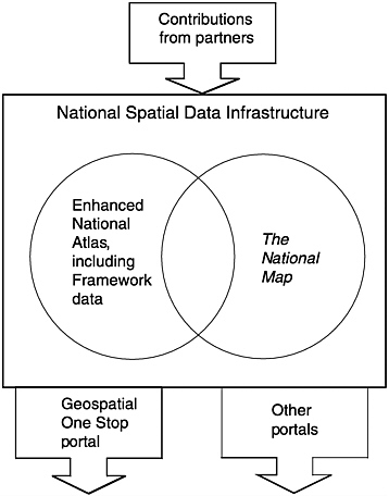
FIGURE 3.1 Relationship of the National Spatial Data Infrastructure (NSDI), the enhanced National Atlas, The National Map, and other components. The NSDI provides the umbrella of data standards, prototcols, partnership arrangements, interagency cooperation, and data. Within this lie the enhanced National Atlas and The National Map. Their overlap represents the processing (generalization) of the large-scale information into the enhanced National Atlas and the filling of “holes” in the patchwork quilt National Map with atlas data when no local data exist.
|
BOX 3.1 The USGS has been publishing National Atlas products since 1970 (see <http://nationalatlas.gov>). Intended for use at national or large regional scales, most of the map layers in the National Atlas are compiled at a scale of 1:2 million and cover the full geographic extent of the United States (although some cover the conterminous United States only). Many federal agencies supply data to the National Atlas, and linkages are provided to agency sources where their information is portrayed. The National Atlas includes the following data services: Make Maps, Online Interactive Maps. Available since 1998. Multimedia Maps. Multimedia technologies are used to supplement and enhance cartographic information products; to tell narrative stories; to deliver interactive maps; to develop maps that show change over time; and to facilitate the visual presentation and understanding of complex geographic phenomena and relationships. Map Services. Over 500 integrated map layers are accessible as two types of Web mapping services. First, Open GIS Consortium-compliant Web mapping services are offered so that developers can embed the National Atlas in their applications, and second, the National Atlas publishes map services through ESRI’s (Environmental Systems Research Institute) Geography Network. Printed Maps. High-quality paper maps depicting a variety of national conditions. Printable Maps. Page-size (8.5 by 11 inch) maps designed for printing and reproduction. Spatial Databases. A variety of information and statistics with a spatial component from federal partners. Metadata. Metadata files include information describing the contents of each map layer, such as how it was made, its lineage, and its quality. Scientific and Expository Articles. Cartographic products are supplemented with narratives. In addition to the National Atlas site several other federal agencies offer similar data or even the same data with different data delivery engines and services. For example demographic information can be viewed, queried, and used to build custom maps on the U.S. Bureau of the Census website and the Bureau of Land Management’s Geocommunicator offers a perspective on federal ownership. |
the patchwork quilt of The National Map.1 The primary differences between the current National Atlas and the enhanced version are scale and theme. The themes would include NSDI Framework data: cadastral, digital orthoimagery, elevation, geodetic control, hydrography, political and administrative boundaries, and transportation. To these would be added geographic names and land use. The equivalent map scales would be those already in use for the National Mapping program, with 1:24,000 (1:12,000 for orthoimagery) being the finest.
Changing the terminology introduced by the USGS is desirable because without a distinction between the two different types of information it will be difficult to sell the National Map concept at the level of the local data contributor. With an enhanced National Atlas there is more task separation: The atlas provides a comprehensive, up-to-date, and uniform map of the nation. By dividing off the quilt from the blanket, at least conceptually, clearer federal responsibilities are evident, and The National Map can become a more participatory and collaborative enterprise. In practice the atlas and map would be intricately linked. In the absence of local participation the spatial content of The National Map would be that of the National Atlas. With participation the enhanced National Atlas would contain the latest updates at specific scales from The National Map.
An Enhanced National Atlas
An enhanced National Atlas could constitute a nationally complete dataset including the Framework data layers as specified for the NSDI, at a series of such scales as 1:24,000 (or perhaps 1:12,000), 1:100,000, 1:1 million, and smaller. The initial contents of the enhanced atlas would be those outlined by the USGS (i.e., geographic names, topography, orthophotography, land cover, hydrography, transportation, structures, and boundaries). To fulfill the needs of the federal mapping community (e.g., BLM, Census, EPA, NASA, NIMA, NOAA, USDA, USGS, and others), it seems of high value and low cost to add coastline data from NOAA, detailed data on the Public Lands Survey System (PLSS), and cadastral data on public lands, geodetic control, and surface geology. Although collectively this is beyond the scope of the USGS topographic mapping responsibility, such a federal collaborative would have many benefits, and continues the spirit of the 1884 National Academy of Sciences report (NAS, 1884) by reducing duplication and increasing collaboration. The
data would be updated with each new change through collaborations between USGS and its partners and forwarded to a state or regional integration office transaction by transaction.
The USGS would be responsible for metadata provision and support, data archiving, and data integration in their role as stewards of the enhanced National Atlas. The first pass could consist of larger-scale Framework data at the 1:12,000 or 1:24,000 scale such as geodetic control, digital orthophotos, PLSS data, and public ownership boundaries. Other data types, such as hydrography and transportation, may not be completed for several years since they require significant integration with other data types at the 1:12,000 or 1:24,000 scale.
The Committee’s View of The National Map
The committee sees The National Map as a suite of data at multiple scales, with variable spatial extent, contributed by National Map partners. Themes would be as in the enhanced National Atlas, but local interpretation and adaptation to scales and conditions would be permitted. Some entries in The National Map would be only metadata, others browse-only thumbnails; and most would be public and private data voluntarily placed in the public domain. The data in The National Map would be accessible through Geospatial One-Stop and other portals, many at federal, state, and local agencies and businesses. The USGS would evaluate and integrate (e.g., reclassify, merge, and mosaic) the data to be consistent with adjacent datasets, and serve as the guarantor of completeness, accuracy and consistency.2 This could be done by a “seal of approval” technique that would go beyond arbitrary paper map standards such as the National Map Accuracy Standard, and instead be modeled on the truth-in-labeling approach used by the Spatial Data Transfer Standard. The basis of certification and metadata would be the individual feature, not the tiling or coverage system. Accepted and certified data and updates would be passed into the enhanced National Atlas and back to the data custodians at the local level. Any patches not filled by local data would be filled by smaller-scale data from the atlas until new local data are collected.
The enhanced National Atlas and The National Map would be core datasets in the NSDI. Data that did not meet National Map standards would reside in the broader NSDI, as they do today. These data could be
|
2 |
The USGS already has experience of the guarantor role through the National Digital Orthophoto Program (see Box 2–2), however the challenge of fulfilling this role for many data themes will be great. |
accessed through a portal of portals, passing the user between distributed sources as necessary. Existing data portals such as Destination: Earth, Gateway to Earth, GeoExplorer, Geography Network, Geospatial One-Stop, and GISDATA Web Mapping Portal could be seen as entry points into the U.S. component of the Global Spatial Data Infrastructure.
PAPER MAPS
The continued production of USGS paper map quadrangles using standard lithographic presses places demands upon the USGS that are inconsistent with a new role as facilitator and custodian of the proposed National Map and atlas. Consequently, new distribution mechanisms are needed. Because of the different user groups, the distribution mechanisms for The National Map and enhanced National Atlas would not completely overlap. The National Map would be distributed on the Internet. The content of the enhanced National Atlas could continue to serve the needs of paper-map users through Internet-linked print-on-demand approaches, yet add new and flexible options.
The USGS goal of liberating the printed map from its spatial reference frame is probably the most appealing to users of hardcopy maps, and there will undoubtedly be a continued demand for paper maps (e.g., see comments of John Voycik, Appendix D, and NRCan, 2002). The flexibility of map printing at arbitrary scale, extent, and theme, and at the user’s convenience is also attractive and could increase the use and demand for map products. Users should be able to print from the Internet, but should also have access to high-quality hardcopy. Barring any restrictions on the file size of downloading capability, FDLP libraries can provide full-size 1:24,000 (24×30 inch) color prints. Map machines at USGS Earth Science Information Centers and at the National Geographic Society can also provide an entire topographic map on a 13×18-inch sheet at scale of about 1:32,000 (through a collaborative project between USGS and the National Geographic Society). These are good examples of what is possible.
The continued production of hardcopy map products is probably a commercial opportunity best exploited by creating USGS partnerships based on the content of the enhanced National Atlas. Commercial map producers have already taken advantage of the accessibility of public domain USGS and other digital map data, such as TIGER files. A healthy map production sector is in the public interest, and also could meet federal needs.
PROPOSED DATA CONTENT
The USGS proposes that its National Map will include the following NSDI Framework data themes (USGS, 2001):
-
Orthoimagery (high resolution) (USGS lead designated in OMB Circular No. A-16, and an NSDI Framework layer);
-
Elevation and bathymetry (high resolution) (A-16 lead on elevation);
-
Hydrography (A-16 lead);
-
Transportation (roads, railroads, waterways);
-
Administrative boundaries; and
-
Publicly owned lands.
Three non-Framework layers also are included:
-
Geographic names (e.g., physical and cultural features) (A-16 lead);
-
Land cover; and
-
Structures.
The USGS vision document also lists potential partnerships to link with such data as geodetic control and bathymetry (both are NOAA responsibilities).
The USGS themes are now examined in the context of two other federally organized spatial data activities with which the USGS project will need to dovetail (not forgetting of course that coordination with state and local activities provides additional integration challenges for the USGS as it pursues its mapping vision).
The Relationship of the National Map Concept to Activities of Subcommittees of the Federal Geographic Data Committee
The Federal Geographic Data Committee has established several thematic subcommittees (see Figure 3.2). These subcommittees are charged with coordination of federal data efforts and developing standards for each theme. The focus of each of these subcommittees is compared to the proposed data content of the USGS’s National Map in Table 3.1. A number of the subcommittees are now discussed in more detail to illustrate the overlap with National Map themes.
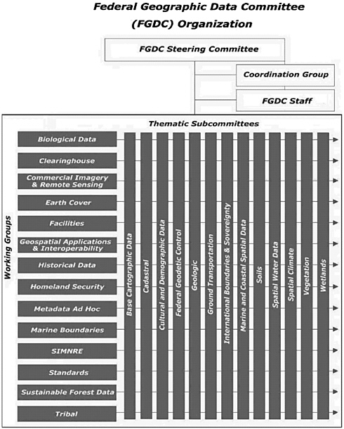
TABLE 3.1 Comparison of Focus of FGDC Subcommittees and Proposed National Map Content
|
FGDC Subcommittees and Lead Department |
National Map Content |
|
Base Cartographic, Department of the Interior |
Orthorectified imagery (high resolution) |
|
|
Elevation (high resolution) |
|
|
Administrative boundaries |
|
Cadastral, Department of the Interior |
Publicly owned lands |
|
Cultural and Demographic, Department of Commerce |
Administrative boundaries |
|
|
Cultural features (geographic names)a |
|
Geodetic, Department of Commerce |
–b |
|
Geologic, Department of the Interior |
– |
|
Ground Transportation, Department of Transportation |
Transportation (roads, railways, waterways) |
|
International Boundaries and Sovereignty, Department of State |
– |
|
Marine and Coastal Spatial Data, Department of Commerce |
Bathymetryb |
|
Soils, Department of Agriculture |
– |
|
Spatial Water Data, Department of the Interior |
Hydrography |
|
Spatial Climate, Department of Agriculture |
– |
|
Vegetation, Department of Agriculture |
Land coverc |
|
Wetlands, Department of the Interior |
Land cover |
|
aThe U.S. Board on Geographic Names is also a source for geographic names. bA partnership with NOAA is proposed in the USGS vision document to provide a link with this data content. cFGDC also has an Earth Cover Working Group that deals with land cover. |
|
Subcommittee on Base Cartographic Data
The orthorectified imagery, elevation and bathymetry, and administrative boundaries are components of the base cartographic subcommittee chaired by the Department of the Interior. According to the charter of the Subcommittee on Base Cartographic Data (FGDC, 2002e) it has “responsibility to coordinate base cartographic data-related activities as assigned to the Department of the Interior.” The activities of the Subcommittee on Base Cartographic Data include standards development in orthoimagery, elevation, positioning, and accuracy. In the context of the USGS’s proposed National Map three provisions of the charter are noteworthy.
-
Determine which categories of base cartographic data are to be included in the National Digital Cartographic Data Base3 and recommend the addition of other categories of base cartographic data not currently being collected.
-
Assist the USGS in establishing and publishing standards and specifications for the data (for example, incorporating conversion to metric units), and assist in establishing priorities for base cartographic data production.
-
Establish and maintain mechanisms for interface among databases of agencies participating in the National Geographic Data System.
Arguably, the USGS National Map vision includes data types and functions (such as standards development) that are the responsibilities of this subcommittee. The data content that falls into the domain of the Subcommittee on Base Cartographic Data is as follows:
Base cartographic data is defined as the fundamental data set of geographic data that is normally produced in the preparation of national series general purpose graphic and digital cartographic products. These data represent the physical and cultural features (natural, artificial, or both) of part or the whole of the Earth’s surface. Used individually or collectively the data can provide the framework upon which other themes of geographic data can
be referenced. Examples of these cartographic data include roads, streams, contours, and geographic and other coordinate reference systems.
Base cartographic features are essentially the standard layers of the USGS seven-and-a-half minute topographic series, which consists of eight overlays.
-
Boundaries;
-
Hypsography (contours);
-
Hydrography;
-
Miscellaneous Culture;
-
Nonvegetation;
-
Vegetation;
-
Geodetic Control; and
-
Transportation.
The National Map content will therefore be familiar to paper and standard USGS digital map product users, promoting continuity. These layers also are multiuse and fundamental to the location of many other objects in different layers. Current USGS map databases that include these themes are available through USGS’s U.S. GeoData program: digital elevation models, digital orthophoto quads, digital line graphs, and digital raster graphics.
Subcommittee on Cadastral Data
The only mention of cadastral data in the National Map vision is with respect to publicly owned lands (USGS, 2001). It is logical for the Bureau of Land Management, which directs the FGDC Subcommittee on Cadastral Data, to have The National Map include its property records in the public domain states. For example, inclusion of the Public Land Survey corners would be an important step in this process. Although it would be beyond the scope of a federal program to include the parcel boundaries of a local cadastre, the value of The National Map would be enhanced by having street centerlines with sufficient positional accuracy to interoperate cleanly with local parcel boundary and centroid datasets. If local government cannot insert its high-resolution parcel-level data, there will be at least two competing versions of base maps for all urban areas of the United States. That would be a waste of time and effort. One driver behind improved cadastral data is from the planning community, which has a growing need for consistent digital cadastral data across political jurisdictions. Another is local taxation and assessment of real
property. At the state level, public lands and holdings are important. In general it is in the national interest that cadastral boundaries of state, local, and federal lands and facilities be available. The USGS has not clearly specified the scope of features that partners and USGS would like included in The National Map. It is important to specify such a scope while the project is still at the concept stage.
Subcommittee on Cultural and Demographic Data
The focus of the FGDC Subcommittee on Cultural and Demographic Data, chaired by the Department of Commerce, translates most directly to the National Map categories of government unit boundaries and cultural features. This subcommittee focuses on data that include the characteristics of people, the nature of dwellings in which they live, the economic activities they pursue, the facilities they use to support their recreational and health needs, the environmental consequences of their presence, and the boundaries, names, and numeric codes of geographic entities used to report the information collected (Bureau of the Census, 2003). These features are likely to be of major interest to The National Map users.
Subcommittee on Ground Transportation Data
The spatial representation of the center of streets is probably the most redundant data theme in the United States. Because of the large number of data collectors and stakeholders, a relationship between the FGDC Subcommittee on Ground Transportation Data and the USGS National Map project is critical and potentially complicated. The FGDC subcommittee is chaired by the Department of Transportation (DOT). This oversight is logical and provides a link to the DOT’s state counterparts. However, the Bureau of the Census maintains the most complete and fully attributed nationwide digital representation of the road network. Since the Bureau of the Census is not a federal mapping agency its road network is really a work product of Census activities and has been designed neither for navigation nor optimized as a base map for large-scale local applications. Consequently, state DOTs and local highway agencies often develop their own versions of many road features for pavement management and facility inventory applications. At the same time, many local governments and private companies, aided by high-resolution imagery and Global Positioning System (GPS) technology, have developed files with a high degree of spatial accuracy that are used extensively for
onboard vehicle navigation, in E911, and to support cadastral mapping. The potential for additional redundancy is increased further by the numerous proprietary and competing versions of street centerlines maintained by the private sector. The FGDC Subcommittee on Ground Transportation has developed a transportation feature standard that we hope will accommodate the needs of most users.
As part of TIGER modernization the Bureau of the Census needs to improve the positional accuracy of its street centerlines and is surveying every county to determine the best version of street centerlines. Ideally, high-quality county files will become part of TIGER and The National Map. A memorandum of understanding between Census and the USGS relating to sharing of street centerline data was signed on September 7, 2001 (Robert Marx, Bureau of the Census, personal communication, 2002).4
Marine and Coastal Spatial Data Subcommittee
The bathymetry theme in The National Map falls within the focus of the Marine and Coastal Spatial Data Subcommittee. Chaired by the Department of Commerce, this subcommittee promotes standards of accuracy and currentness in bathymetric and nautical charting data financed in whole or in part by federal funds. The subcommittee also exchanges information on technological improvements for collecting bathymetric and nautical charting data; encourages the federal and nonfederal community to identify and adopt standards and specifications for bathymetric and nautical charting data; and collects and processes the requirements for federal and nonfederal organizations for bathymetric and nautical charting data (NOAA, 2002).
The Earth Cover Working Group
The USGS has a long history of conducting studies that deal with land cover. It is therefore appropriate that land cover be a part of their vision. Work on this component should be coordinated with the work of the FGDC’s Earth Cover Working Group to establish consistent protocols
and classification standards for land cover. The working group promotes an integrated, standardized, cost-efficient approach to identifying, classifying, and mapping features that cover the surface of the nation. The land cover component should also coordinate with the efforts of the FGDC Vegetation and Wetlands Subcommittees (FGDC, 2002a) to ensure consistency between the National Map land-cover theme and vegetation and wetland areas.
Framework Data
Over the past decade a consensus has evolved on how to build an integrated spatial database that will provide a consistent base for a wide range of applications. The construction process is analogous to constructing a building. The building must have a sturdy foundation or framework to survive. The geospatial community has settled on the term “Framework” to describe this foundation. Framework data is commonly used to describe seven themes of digital geographic data.
-
Geodetic control;
-
Orthoimagery;
-
Elevation;
-
Transportation;
-
Hydrography;
-
Governmental units; and
-
Cadastral information.
The National Digital Orthophoto program (see Box 2.2) illustrates how a Framework data theme can be completed.
There are commonalities between the USGS’s proposed National Map content and Framework themes. The Geospatial One-Stop project (see Box 1.4), which relies heavily on existing structures within the FGDC, aims to accelerate the development of these themes, as recommended in the NRC report The Data Foundation for the National Spatial Data Infrastructure (NRC, 1995) (see Appendix C). Furthermore, Executive Order 12906 (see Appendix C) stipulates that FGDC is to consult with state, local, and tribal governments and submit a plan and schedule to OMB for completing the initial implementation of a national digital geospatial data “framework” by January 2000.5
The FGDC has endorsed the concept of Framework data (FGDC, 2002f).
The framework is a collaborative community based effort in which these commonly needed data themes are developed, maintained, and integrated by public and private organizations within a geographic area. Local, regional, state and federal government organizations and private companies see the framework as a way to share resources, improve communications, and increase efficiency.
With specific reference to the Framework data content the FGDC states that
[t]he framework represents “data you can trust”—the best available data for an area, certified, standardized, and described according to a common standard. It provides a foundation on which organizations can build by adding their own detail and compiling other data sets.
The potential carried by Geospatial One-Stop to accelerate development of the Framework layers offers a means of fueling advancement of USGS’s vision. Lessons learned in implementing partnerships across all levels of government through Geospatial One-Stop, in addition to those learned by the FGDC over the last decade, will be invaluable to the USGS as it continues its mapping activities beyond the lifespan of Geospatial One-Stop. For example, the proposed “data-acquisition bazaar” may evolve into a national marketplace for data acquisition that promotes economically efficient allocation of financial resources at all levels of government (e.g., see comments of Scott Cameron, Appendix D). The USGS will need to work within the FGDC structure as it proceeds with partnerships and standards development relating to The National Map.
PROPOSED DATA CHARACTERISTICS
The USGS has laid out a series of goals for the characteristics of data layers within its National Map (see Chapter 1 and USGS [2001]). As with any such exercise, a number of challenges must be addressed to attain these goals. Issues, challenges, and questions raised by workshop participants and the committee on these data characteristics are summarized in Table 3.2. There was broad agreement among workshop participants and the committee that the characteristics outlined by the USGS for The National Map are valuable to the nation.
TABLE 3.2 Issues, Challenges, and Questions Relating to the Proposed Characteristics of Data Layers in The National Map
|
Data Characteristic |
Issues/Challenges/Questions |
|
Current (seven days) |
Issues and Challenges: This is the most challenging characteristic. It would also be a great asset. The challenges are largely institutional. Tracking the transactions would require extraordinary levels of collaboration. Although the seven-day schedule may be demanding,a there are many application domains that require real-time data.b |
|
|
Questions: • What are the triggers of change and updates? • Who reports a change? What is the role of volunteers? • What is the baseline and when is it updated? • How does currency vary for different themes? • How will the database support real-time applications (traffic, disasters)? • What constitutes a transaction? • How will users be notified of changes? • Can a geographic subscription service be provided (pushed to the subscriber)? • How are changes archived? |
|
Seamless |
Issues and Challenges: It is desirable for the USGS to move from a quadrangle-centric view of spatial data to one without artificial map sheet boundaries (i.e., accessible for arbitrarily defined study areas). Technical solutions already exist that enable spatial databases to function seamlessly. When dealing with large areas, the data volumes can be enormous, and bandwidth will be a real constraint. |
|
|
Questions: • Is TIGER modernization a good model to follow? • Can edge matching be handled automatically? • How to ensure that features are not duplicated or do not stop artificially? • How is seamlessness defined with respect to data source, scale, and time? Can a data layer compiled in a patchwork quilt model over time ever be truly seamless? • How to maintain consistent classification of features? • How will adjacent data from many sources be integrated? |
|
Data Characteristic |
Issues/Challenges/Questions |
|
|
• How will metadata be displayed for possible different sources across any given geographic expanse? • How can the Geographic Names file be processed to remove tile or quadrangle dependencies? |
|
Consistently classified |
Issues and Challenges: Consistent classification standards are essential. The relevant FGDC standards must be followed and described in the metadata. Classification schemes should adhere to professionally adopted and disciplinary standards by theme. There will also be a need for translators, crosswalks, and support for alternative user-profile systems. In a Web environment a user profile could enable a user to develop a personalized or customized view of The National Map (“My National Map”). For example, some users may want to group land cover into simple categories such as “developed,” whereas others may want “residential.” |
|
Variable resolution |
Issues and Challenges: Variable resolution is a practical and cost-effective characteristic. There are several technical issues that need to be addressed and the resolution of any given data set for any area must be defined in the metadata. The USGS should approach resolution as a federal issue first (not local or state). FEMA suggests 1:12,000-scale (based on DOQ) for general mapping, but floodplains need higher-resolution data. The edge-matching problems caused by variable resolution will be severe and not always solvable. Additionally, there will be classification issues (e.g., land cover classification levels changing with resolution). Minimum mapping unit size will affect the classification, and problems related to classification of different-resolution source materials will need to be addressed. Lastly, there will be cartographic problems (e.g., appearance). |
|
|
Questions: • What are the minimum scale requirements: 1:24,000? 1:12,000? Is the plan to begin with the 1:24,000 topographic series or will the USGS begin with remote sensing, where the problem of edge matching is not an issue? • Are we limiting “resolution” to only raster data? Note that resolution and accuracy can affect attributes information and apply to raster and vector data. • Is it desirable to have resolution vary by theme? |
|
Data Characteristic |
Issues/Challenges/Questions |
|
|
• How to integrate multiple resolution data with variable positional accuracy? |
|
Complete |
Issues and Challenges: If The National Map is to be a trusted source, it must strive to be complete. That means every specifiable spatial feature should be included. The Spatial Data Transfer Standard (SDTS) includes a comprehensive list of spatial features that should be followed. |
|
|
Questions: • What is the spatial extent of map coverage (i.e., does it cover Alaska, U.S. Territories, overseas military bases)? • There are definitional problems as well as problems with minimum size: features, spatial extent, attribution, status, or state minimum mapping units. For example, what constitutes federal property? Would every post office be included? |
|
Consistent and integrated |
Issues and Challenges: The issues of consistency and integration are significant ones.c When users access the data, they need to have confidence that the data can be used in their applications with minimal manipulation. Themes that are logically connected (e.g., watershed boundaries, digital elevation models, streams) must be positionally correct to support analytical operations, and there should not be any cartographic displacement. Feature data as opposed to layers would allow one feature to be included in many contexts, greatly facilitating updates. |
|
|
Question: • Are the layers logically integrated (e.g., drainage-enforced digital elevation models)? |
|
Variable positional accuracy |
Issues and Challenges: As with the notion of variable resolution, it is practical and cost effective to capture features from different-scale source material for urban and rural areas. Therefore, the positional accuracy of features will vary. The important issue is to report the reliability in the metadata. The FGDC standard for transportation features is a good model for other feature types. |
|
Data Characteristic |
Issues/Challenges/Questions |
|
Consistent spatial reference |
Issues and Challenges: The spatial reference system should meet standards for point positioning established by the SDTS. A national system is best served by a geographically referenced system based on latitude and longitude adjusted to a modern datum (ultimately, users must be able to select various map projections, and the latitude-longitude system is the best starting point). The national system should be NAD 83 with coordinates reported to seven decimal places. The vertical dimension should be referenced to NAVD 88. Most states require state plane coordinates; therefore there must be education and training about best practices in terms of projection changes and differences in U.S. survey and international feet. The USGS should play a leadership role in educating, providing software, and certifying accurate coordinate system, datum, and projection transformations. |
|
Standardized |
Issues and Challenges: The issue of standardization is paramount and is mandated by OMB Circular No. A-16 and other policies. Data elements must be endorsed by the FGDC. |
|
Documented (FGDC metadata) |
Issues and Challenges: FGDC and ISO (International Organization for Standardization) metadata standards should apply. To be trusted and valuable to the broadest community it should include feature-level metadata, which is particularly important for the temporal dimension, reporting accuracy, and tracking lineage.a,b |
|
|
Question: • What is the most useful level of detail and who would provide the detail? |
|
Temporally tracked and archived |
Issues and Challenges: Tracking changes to features on the Earth’s surface is a core scientific competency of the USGS, and this approach should be supported. This approach is the only cost-efficient way to support longitudinal studies, to do systematic archiving, and for rapid update. There are many practical problems related to how to implement and maintain a temporally accurate database. There must be a practical business model to support this, or it will not be reliable. |
|
Data Characteristic |
Issues/Challenges/Questions |
|
|
Questions: • What should be the temporal interval for archiving and tracking (monthly, annually), and who captures, synchronizes, and posts the changes? • What type of archive methods will be used (retired features, snapshots, versioning)? |
|
|
|
|
a |
See Appendix D, comments of Robert Marx. |
|
b |
See Appendix D, comments of Donald Cooke. |
|
c |
See Appendix D, comments of William Craig. |
|
d |
See Appendix D, comments of Curt Sumner |
ARCHIVING DATA
The suite of systems designed to ensure the reliability and survivability of the content for The National Map and enhanced National Atlas will likely parallel those developed for paper maps and now applied to digital map archives. Past digital map data now represent on the order of petabytes of information, and the needs of the various archive systems must be taken into account at the outset for the long-term effectiveness of the contents. One concern is the question: Can the specific contents of The National Map and enhanced National Atlas be reconstructed effectively as they existed at a specific point in time? If so, not only will the survivability of the data be improved, but a new field of research and even business may form to understand and track the dynamics of geographic phenomena over time. For example, one private digital map company conducts considerable business by being able to recreate the ownership and land use of a single cadastral parcel or city block over long periods of time (Sanborn, 2002).
There is a federal role in data archiving in addition to the existing NSDI clearinghouse websites and potential private-sector roles. The Federal Depository Library program (FDLP) was established by Congress to ensure that the American public has access to federal government information. The FDLP involves the acquisition, format conversion, and distribution of depository materials and the coordination of Federal Depository Libraries in the 50 states, the District of Columbia, and U.S. territories. The mission of the FDLP is to disseminate information products from all
three branches of the government to nearly 1,300 libraries nationwide. Libraries that have been designated as federal depositories maintain these information products, including maps and digital map data, as part of their existing collections and are responsible for assuring that the public has free access to the material (see comments of Ernest Baldwin, Appendix D, and GPO [2000]).
There is an established base, in a paper environment, for disseminating and archiving USGS and other spatial data through the FDLP. Following the congressional mandate in 1995 for GPO to change to an all-electronic FDLP, the minimum technical requirements for public access workstations in federal depository libraries (GPO, 2002a) required libraries to purchase equipment and develop the ability to provide access to the electronic data they were receiving through the FDLP. This required a significant investment by libraries to retain their depository status, and training has been provided at annual federal depository conferences in Washington, D.C.
The FDLP role could be expanded and extended by the USGS concept as proposed. Two potential new elements would be the need to interact with local, tribal, state, and private agencies that are data holders but whose data is searchable by public domain metadata; and the requirements for transaction-based updates. The latter, an alternative to versioning, will require research. Partnerships with FDLP libraries, GPO, and other agencies and groups (e.g., Digital Library Federation, National Science Foundation, and national supercomputer centers) could be sought by the USGS to develop appropriate archiving methods and sites. The ongoing FDLP Partnership program (GPO, 2002b) provides examples of archiving partnerships, albeit not for spatial data. In this program GPO facilitates partnerships with federal agencies from its network of FDLP libraries.
The archiving of spatial data is a continual challenge, and assuring the reconstruction of data at any given point in time, as well as ensuring the data’s continuing viability through time, add to that challenge. The technology developed to meet this challenge will have far-reaching applicability, and the benefits of timely, accurate, and accessible data cannot be overstated.
VOLUNTEERS
Another component of the USGS proposal is the collection of data from users acting as volunteers. The contribution of data by private citizens (including school children on “GIS days”), although perhaps of value for publicizing and enhancing The National Map, best services the
broader body of contributed uncertified data linked to the user through the NSDI similar to ESRI’s Geography Network.
Volunteer programs are not alien to federal programs. For example, since 1994 the Environmental Protection Agency’s Oceans and Coastal Protection Division has used volunteers for estuary monitoring (EPA, 2001). Citizen contribution of USGS certified data could meet with disapproval from professional surveyors, however (e.g., see comments of Curt Sumner, Appendix D). In an alternative approach the Delaware National Map pilot project (see Table 2.1) was able to use citizen data corrections effectively, with an e-mail feedback system to correct errors, and volunteers from the nonprofit United States Power Squadrons submit nautical chart corrections to the National Ocean Service (USPS, 2002). Such a system would be a good model for a volunteers program, whereas certification is beyond the scope of the federal government. The USGS will need to carefully review the role of volunteers. Any solution will need to be worked out with input from relevant professional organizations.
THE PUBLIC DOMAIN
The concept of the public domain is important in any discussion of the role of government information in promoting a ubiquitous information infrastructure. The USGS proposes in its vision document to place all data in the public domain (USGS, 2001). Edward Samuels defines the public domain in the U.S. setting as “works” divided into the following categories:
[W]orks for which the term copyright has expired; works that are otherwise eligible for protection, but in which copyright has been forfeited because of a failure, either by design or by mistake, to comply with the copyright formalities in effect at the time; and works that are non-copyrightable because they are categorically excluded from federal copyright protection (Samuels, 1993).
Public domain map data have played a key role in stimulating innovation in the multibillion-dollar geographic information industry, one in which the United States leads the world. This role is remarkably consistent with the spirit of “public domain” in the 1884 National Academy of Sciences report, though the meaning has changed radically. Clearly, national goals and priorities should override those of individual agencies. It would be poor policy to hold back public spatial information for purposes of cost recovery or for private licensees, a lesson that was
learned at great expense in past experiments with commercialization (Brown, 1997). The marketplace has been driven by low-cost public datasets that can be enhanced to serve a variety of end uses. The USGS must recognize the requirements of commercial data vendors if they are to promote value-added processes resulting from The National Map and enhanced National Atlas. For-profit and not-for-profit intermediaries play a significant role in a spatial data infrastructure by providing spatial data products and services that cannot be provided by government suppliers. For-profit enterprises add value to existing government information, such as improved detail, rearranged content, improved quality, or commercial applications. Currently such cooperation is only beginning to evolve. Commercial data providers are obvious partners in the USGS vision and have much to contribute.
Interorganizational partnerships, such as Cooperative Research and Development Agreements (CRADAs), between government agencies and for-profit and not-for-profit organizations require new transaction and valuation methods for exchanging information commodities. Public agencies should be careful in applying market approaches, and there are examples of failures for this reason (e.g., NCGIA, 1993). Basing the dissemination of public information on market concepts rather than on efficiency, effectiveness, fairness, and equity may reflect unfounded concepts. Also, with the presence of inherent network externalities in electronic markets, the successful exploitation of information products and services is fundamentally different from more conventional products and services. Recognizing these factors is critical if policy makers are to avoid pricing practices and accompanying regulatory mechanisms based on principles designed for a previous (industrial) economy. If a public policy objective of the USGS is to promote the wide availability, use, and downstream commercialization of The National Map, it is appropriate to consider reducing intellectual property and pricing impediments as an incentive for third parties to acquire and commercialize these data. By reducing such impediments information policy is crafted to parallel the national objectives for funding basic research, while stimulating the growth of emerging information industries (Lopez, 1998).
Assumptions about the value of public information in the public domain are set forth in OMB Circular No. A-130. The underlying principle for these assumptions is that government spatial data resources provide a fundamental framework that sustains a horizontally and vertically integrated spatial data infrastructure that is open, diverse, and innovative. Such a public infrastructure is critical to the development of a marketplace of ideas, products, and services.
A final consideration in the discussion of the public domain is data security. For example, local governments may want to integrate private utility data into local datasets for public safety or infrastructure design programs. Without assurances that their critical data would be publicly unavailable, full cooperation of local entities with the USGS program is unlikely. The USGS will need to review issues related to security of proprietary and other limited access data in conjunction with the public domain. While the coarser nature of the enhanced National Atlas scale will protect much of the content, other means of addressing security will need to be researched and clarified to all potential partners.
SUMMARY
The committee sees advantages in labeling the integrated, nationally consistent database (the “blanket”) as the enhanced National Atlas, building from the success of an existing program. The National Map would be a “patchwork quilt” of data and metadata contributed from local, state, tribal, and private agencies. As a result of partnership arrangements coordinated by the USGS, these data would be submitted to the USGS for checking and some would gain official inclusion in the enhanced National Atlas. The partnerships would leverage existing data, reduce duplication of effort, and improve timeliness of updates.
Content for The National Map and the enhanced National Atlas should be thematically identical at their core but allow for variants in scale and specifications at the local level. The pertinent themes include the Framework and base cartographic layers and the thematic layers identified in OMB Circular No. A-16. These are already the subject of discussion and standards development within the FGDC, and there is much to be gained by using these specifications for the thematic content of The National Map and enhanced National Atlas. The data should be in the public domain and should be integrated into the Federal Depository Library program. Lastly, there may be value in incorporating direct input from the general public, especially in detecting errors and making updates.


