
1
Introduction
For much of the 20th Century the Everglades epitomized the American conflict between unbridled economic development and environmental conservation. Now the region has become a 21st Century symbol of the nation’s commitment to sustainability achieved by protecting and restoring native species and ecosystems while meeting human needs for space and natural resources.
A BRIEF HISTORY OF THE EVERGLADES
The South Florida ecosystem (Figure 1-1 and 1-2) stretches from north of Lake Okeechobee to the Florida Reef Tract, and includes parts of 16 counties (USACE and SFWMD, 1999). While part of the system lies on ancient limestones, the Everglades peatland formed only during the past 5,000 years as sea level rose from its Ice Age low to its present level (Gleason and Stone, 1994). Alteration of the natural system began on a small scale in the mid-1800s, as over 50,000 acres north and west of Lake Okeechobee were ditched, drained, cleared, and planted for agriculture (Trustees, 1881). In 1907 Governor Napoleon Bonaparte Broward created the Everglades Drainage District (Blake, 1980), and by the early 1930s, 440 miles of canals dissecting the Everglades had been constructed (Lewis, 1948).
At least as early as the 1920s, private citizens had been calling attention to the degradation of the Florida Everglades (Blake, 1980). However, by the time Marjorie Stoneman Douglas’ classic book The Everglades: River of Grass was published in 1947 (the same year that Everglades National Park was dedicated), the Greater Everglades Ecosystem had already been altered extensively to accommodate human habitation of the region, industry, and agriculture.
This trend only accelerated when disastrous floods of 1947-1948 led to the Central and Southern Florida Project for Flood Control and Other Purposes. This initiative employed levees, water storage, channel improvements, and large-scale pumping to supplement gravity drainage of the Everglades. It also created a 100-mile perimeter levee to separate the Everglades from urban development, effectively eliminating 160 square miles of Everglades that had historically extended east of the levee to the coastal ridge (Light and Dineen, 1994;
Lord, 1993). The project then partitioned the remaining northern sawgrass and wet prairie (Figure 1-1) into conservation areas (Figure 1-2), separated by levees, designed primarily for water supply and flood control, with some provision for wildlife habitat and recreation. The Everglades Agricultural Area (EAA) was created just south of Lake Okeechobee (Figure 1-2), facilitated by the construction of a dike spanning the entire circumference of the lake.
These and other projects were undertaken primarily for flood control, to support agriculture, and to provide dry land for development, and they have led to severe ecological consequences. Currently, by comparison with the earliest available estimates of the ecosystem and its components, populations of wading birds have declined by 85-95 percent; 68 plant and animal species are threatened or endangered; over 1.5 million acres are infested with invasive,
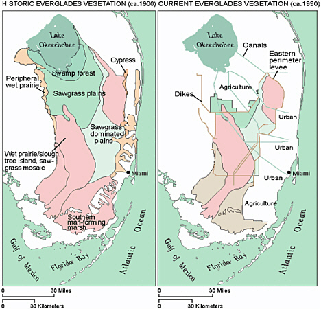
FIGURE 1-1. Historic and current Everglades vegetation. Source: Galloway et al., 1999.
exotic plants; and 1 million acres are contaminated with mercury (McPherson and Halley, 1996).
In response to these alarming ecological trends, the federal Water Resources Development Act of 1992 (WRDA) authorized a massive and comprehensive review of the Central and Southern Florida Project to examine the potential for restoration of the Greater Everglades Ecosystem. The result of the review, known as the Restudy, was the Comprehensive Everglades Restoration Plan (CERP). The National Research Council’s (NRC’s) Committee on the Restoration of the Greater Everglades Ecosystem (CROGEE) was established in response to requests from the U.S. Department of the Interior and the U.S. Congress to provide advice on scientific aspects of the design and implementation of the restoration plan. The charge to the CROGEE that resulted in this effort is describe in the executive summary. The WRDA of 2000 required an “assessment of ecological indicators and other measures of progress in restoring the natural system,” and this report also provides some basis for such an assessment.
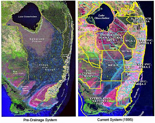
FIGURE 1-2. Historic and current Everglades major features. WCA = Water Conservation Area [1, 2, and 3], LEC SVC. = Lower East Coast Service [Areas 1, 2, and 3]. Source: Adapted from Robert Johnson, Everglades National Park, presentation given to NRC Panel to Review the Critical Ecosystem Studies Initiative, 2002.
THE RESTORATION PLAN
The Comprehensive Everglades Restoration Plan (hereafter referred to as “the Restoration Plan”) is the largest restoration effort ever pursued from the standpoint of the size of the ecosystem (28,000 square kilometers) and the number of individual construction/destruction projects (nearly 200). The current Restoration Plan and its individual projects are designed to achieve more natural controls of the half of the Everglades ecosystem that remains after more than a century of extensive human alterations to the ecosystem (Figure 1-1). The broad goals of the Restoration Plan are “to restore the natural hydrology of south Florida, to enhance and recover native habitats and species, and revitalize urban core areas to reduce the outward migration of suburbs and improve the quality of life in core areas” (SFERTF, 1998) (Box 1-1). The plan is led by a federal agency, the U.S. Army Corps of Engineers, and a state agency, the South Florida Water Management District.
As broad an effort as the Restoration Plan is, it is only part of a larger restoration effort involving research by a myriad of federal, state, and local agencies, universities, and native American tribes. The South Florida Ecosystem Restoration Task Force (http://www.sfrestore.org/tf/index.html) is charged with developing the strategic plan that will integrate the projects into a single framework to restore the south Florida ecosystem.
A fundamental premise of the Restoration Plan is that restoring the historical hydrologic regime to the remaining Everglades system will reverse well-documented declines in many native species and biological communities. The cornerstone of the overall effort to restore the ecosystem is to restore the natural hydrology of the ecosystem. The basic strategy of the Restoration Plan is to capture and store freshwater currently discharged to the ocean for use during the dry season; 80 percent of the captured water is to be used for the natural system while 20 percent is for agricultural and urban uses (Central and South Florida Restudy, April 1999). The plan calls for removal of 240 miles of levees and canals and building a network of reservoirs, underground storage wells, and pumping stations that would capture water and redistribute it to replicate natural hydroperiods. To “get the water right”—the mantra of the Restoration Plan—the plan proposes construction of 68 major projects over an estimated 36 years at a cost of $7.8 billion (1999 estimate). These projects are expected to recreate historical quantities, quality, timing, and distribution of water in the natural system while meeting the needs of the built environment (and its people) for freshwater and flood protection. Clearly, getting the water right by this strategy and with these constraints will require that the Everglades continue to be an intensively managed ecosystem even after the projects outlined in the Restoration Plan are complete.
The Restoration Plan was conceived and designed based on extensive monitoring, experimental research, and modeling. However, scientists and managers involved in the restoration recognize that there are very large scientific, engineering and political uncertainties associated with a restoration project of this scope and complexity. In particular, the relationship between the historical hydrologic regime and modern ecosystem composition, structure, and functioning remains somewhat hypothetical given the greatly reduced size and altered proportions and flow ways of the modern system and the degradation of water quality. Exogenous factors such as sea-level rise, continuing human development of southern Florida, the spread of invasive exotic species, and atmospheric mercury deposition may confound the best restoration designs. There is the added uncertainty associated with some of the proposed engineering solutions such as large-scale aquifer storage and recovery, not to mention the uncertainty of project funding over its 30-year plus duration. Some uncertainties can only be
resolved by taking action; even without full knowledge of how the ecosystem will respond. Interventions themselves will create change, which can only be understood in retrospect. Comprehension will always lag behind observation.
In the face of these uncertainties and surprises, the ability of the Restoration Plan to achieve its stated restoration goals depends on fully incorporating and maintaining scientific research throughout the restoration program (Box 1-1). In the last decade, science’s role in Everglades restoration has been formalized in two main ways. The first of these is the Science Coordination Team or SCT (http://www.sfrestore.org/sct/index.html), which has evolved from the Science Subgroup established in 1993 by the South Florida Ecosystem Restoration Task Force as an interagency science advisory team. The second is called Restoration, Coordination, and Verification, or RECOVER (http://www.evergladesplan.org/pm/recover/recover.cfm), an entity created by the agencies leading the Restoration Plan. RECOVER’s goals are to evaluate and assess plan performance, recommend improvements in the plan’s design and operational criteria, review the effects of other restoration projects on the plan’s performance, and ensure a system-wide perspective. This focus on the Restoration Plan rather than on the broader multi-agency restoration effort makes RECOVER’s mandate somewhat narrower than that of the Science Coordination Team.
The Restoration planners, scientists, and managers must develop and promote a culture of healthy skepticism, openness and learning. A well-designed and well-supported program of monitoring and assessment is critically important to this process. Accordingly, the Adaptive Assessment Team (AAT) was created by RECOVER and given lead responsibility to develop a Monitoring and Assessment Plan (MAP) for the project. The AAT has defined monitoring as “the systematic process of collecting and storing data related to particular natural and human systems at some specified locations and times” and assessment as the interpretation of monitoring data “in the context of particular questions and issues.” The Restoration Plan is to
|
BOX 1-1 Greater South Florida Restoration Goals. The broad goals are “to restore the natural hydrology of south Florida, to enhance and recover native habitats and species, and revitalize urban core areas to reduce the outward migration of suburbs and improve the quality of life in core areas.” (SFERTF, 1998). Central and South Florida Restudy Goals. The overarching goal of The Restudy was to determine how best to:
|
be implemented in an “adaptive assessment” framework that allows for changes in project design and management based on knowledge provided through synthesis of information that has been collected by a monitoring and assessment program.
The AAT envisions the Monitoring and Assessment Plan as a single, integrated system-wide monitoring and assessment program that will be used to determine if ecosystem response to the Restoration Plan is progressing towards the objective of restoration, preservation and protection of the ecosystem while providing for other water-related needs of the region. Ultimately, the AAT envisions that the final monitoring and assessment plan will consist of five major sections: 1) identification and measurement of ecological indicators, 2) design of the monitoring network (e.g. temporal and spatial scales of measurement), 3) implementation plan for sampling, 4) analysis of the indicators to assess ecosystem response, and 5) research needs in support of the monitoring and assessment. To date, most of the effort of the AAT has focused on ecological performance measures.
COMPREHENSIVE EVERGLADES RESTORATION PLAN GOALS
The overarching goal of the CERP is to “get the water right” by restoring historic hydrologic conditions in the natural ecosystem. The objectives of the CERP are to create historic quantities, quality, timing, and distribution of water in the natural system while at the same time providing fresh water to the built environment and protecting the built environment from flooding.
The CROGEE recognizes that the monitoring and assessment process for the Restoration Plan provides the critical scientific basis for plan evaluation and improvement (mid-course corrections in the lexicon of adaptive management). Together with scientists and staff of the AAT, the CROGEE devoted several meetings to the subject, culminating in an Adaptive Monitoring and Assessment Workshop in November 2001. This report summarizes the perspectives and findings of the CROGEE regarding the Restoration Plan Monitoring and Assessment Plan dated March 29, 2001 and supplemental materials published at http://www.evergladesplan.org/ as of June 1, 2002. The introduction to the Monitoring and Assessment Plan (at http://www.evergladesplan.org/pm/recover/recover.html) is in Appendix E. Because the Monitoring and Assessment Plan is still evolving, this report does not dwell on specific indicators or protocols (the performance indicators in the 2001 version of the plan are provided in Appendix E for information). Instead, it reviews the general approach and design of MAP in order to highlight the major strengths of the program as well as issues of potential concern. As a result, it is likely that some of the recommendations of this report are already being pursued. The CROGEE expects to continue to focus considerable attention on this aspect of the Restoration Plan.


