
1
Introduction
The Everglades’ ecosystem of South Florida, aptly described as a “river of grass” (Douglas, 1947), once encompassed about three million acres of slow-moving water from Lake Okeechobee drainage basin to Florida Bay (Figure 1-1). Today, it has decreased to about half of its original size as the result of drainage and flood control projects employed to support expanding human settlements. The consequences of these projects have altered the ecosystem to its current degraded state.
As a consequence of decades of effort, in 1999 the Comprehensive Everglades Restoration Plan (CERP, referred to throughout this report as “the Restoration Plan”) was unveiled with the overarching goal of restoring the historical hydrologic conditions to what remains of the natural ecosystem. The main purpose of the Restoration Plan is to achieve restoration by “getting the water right”, i.e., improving the quality, quantity, timing and distribution of the water in the Everglades, while also providing for the water supply and flood control needs of the south Florida region (USACE and SFWMD, 1999). The Restoration Plan is the world’s largest ecosystem restoration project; it will cost an estimated $7.8 billion (1999 price level) and take more than 20 years to complete. Appendix D provides a more detailed background and history of Everglades restoration.
“Getting the water right” has largely meant restoring the timing and duration of water levels and the water quality in various portions of the Everglades. Water flow has been considered mainly in the context of discharge to estuaries, but not elsewhere. There are a number of legitimate reasons why flow, in terms of direction, speed, and rate, has not been emphasized in the Restoration Plan. There exists very little information on pre-disturbance flow, and what is available is relatively imprecise. Post-disturbance flows are poorly quantified, except at flow structures and in canals.
Modeling of water flow is not very helpful for quantifying flows. Although the Natural System Model and the South Florida Water Management Model provide useful estimates of gross system inflows and outflows, estimates of flows within the system are much less accurate (Bales et al., 1997). Furthermore, neither model currently resolves overland flows at scales smaller than the two-mile by two-mile grid system. Low gradients, complex microtopography,
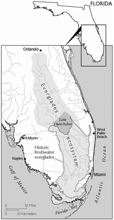
FIGURE 1-1 Greater Everglades Ecosystem. Source: Galloway et al., 1999.
and dense vegetation make it extremely challenging to model overland flows in the Everglades at a much finer scale.
There is, however, strong circumstantial evidence that flow affects important physical, chemical, and biological processes in the Everglades. Flow enhances mixing, particularly across the water-substrate interface. Flow, even at very low rates, is likely to transport biologically important materials including nutrients, organic matter, gases, and reproductive propagules such as seeds and spores (Mitsch and Gosselink, 2000). Furthermore, since flux (quantity/time) is the product of concentration (quantity/volume) x flow rate (volume/time), transport rates generally increase with flow rate (unless there are supply limitations).
More importantly, there are major landforms in the Everglades, most notably parallel sawgrass ridges, open-water sloughs, and tree islands, that are ecologically significant and aligned with present and past flow directions (see Figures 2-1, 2-2, and 2-3). This alignment suggests that their genesis and maintenance have been importantly shaped by flow.
During the last few years there has been an increasing concern about whether the ecological objectives of the Restoration Plan can be achieved to the extent desired without greater attention to the issue of flow. To focus on this issue, the Science Coordination Team sponsored a flow workshop at the Greater Everglades Ecosystem Restoration (GEER) conference, held in Naples, Florida in December 2000. They then prepared a white paper on the role of flow velocity in the Everglades ridge and slough landscape, had it peer-reviewed, and released it in final form in January 2003 (SCT, 2003). Between the peer review and the final release, the CROGEE held a Workshop on Flows and Levels in the Ridge and Slough Region of the Everglades in Miami, FL on October 15, 2002 to gather additional background and information and to discuss the science underpinning the White Paper’s conclusions and recommendations (see Preface and Appendix A). Another flow workshop was held at the April 2003 GEER conference.
This report evaluates the SCT White Paper’s conclusions and recommendations with respect to the environmental significance, creation, maintenance, degradation, research needs, and performance measures for flow in the ridge and slough landscape.


