
2
The Ridge and Slough Landscape: Significance, Degradation, Origin, and Maintenance
Historically the peat-based ridge and slough landscape was the predominant feature of the central Everglades, encompassing what are now Water Conservation Areas 1 (Loxahatchee National Wildlife Refuge), 2, and 3, and extending into Shark River Slough (Figure 2-1). This landscape is composed of a parallel arrangement of rather evenly spaced sawgrass ridges and open water sloughs characterized by aquatic vegetation and generally the year-round presence of water above the soil surface (Figure 2-2). In its pristine state, the soil surface of ridges is two to three feet (60 to 90 cm) higher than that of the sloughs (Wright, 1912; and Baldwin and Hawker, 1915 cited in SCT, 2003). In spite of this elevation difference, ridges are also covered with water for most or all of the year. Ridges can dry out entirely during the dry season. Tree islands (Figures 2-2 and 2-3) are a third element in this landscape. Tree islands are even higher in elevation than ridges, and tend to have exposed soil at all times except during periods of unusually high water.
OVERVIEW OF THE WHITE PAPER
The SCT White Paper (SCT, 2003) makes, and provides support for, the following assertions:
-
The ridge and slough landscape is highly significant ecologically.
-
The landscape is severely degrading in a number of locations, i.e., it is being replaced with a landscape that is more uniform in terms of both topography and vegetation, and has less directionality.
-
This degradation is due both to changes in water depths and hydroperiods and to changes in the spatial pattern of flow velocity (speed and direction).
-
The exact mechanism for degradation is not known.
-
The landscape will degrade further unless the appropriate water velocities (speed and direction), timing, and distribution are restored.
Based on these assertions, the White Paper:
-
outlines priorities for research to determine the processes that maintain the ridge and slough landscape, and
-
suggests new performance measures based on ridge and slough geometry.
The White Paper stops short of recommending that performance measures directly related to flow be instituted at this time. Instead it points out that there are tradeoffs involved with attempts to restore water flow, water levels, and hydroperiods, largely because there is not enough water. Until more is known about the role of flows, restoration emphasis should be placed on levels and hydroperiods.
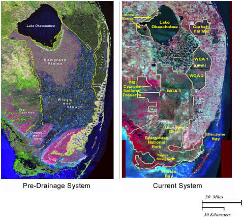
FIGURE 2-1. The ridge and slough landscape in the context of the major features of the historic and current Everglades. WCA = Water Conservation Area [1, 2, and 3], LEC SVC. = Lower East Coast Service [Areas 1, 2, and 3]. LNWR = Loxahatchee National Wildlife Refuge. The pre-drainage system depicted above is a synthetic satellite image reconstructed by the SFWMD Hydrologic Systems Modeling Division using the Natural System Model (NSM) Version 4.5. The NSM simulates the hydrologic response of the pre-drainage Everglades system to historical (1965-95) meteorologic data. This is the view of the landscape that was likely to have existed circa 1850. This image can be found on http://sofia.usgs.gov/sfrsf/rooms/hydrology/water/wherebefore.html. Current system from Adaptive Assessment Team (2003).
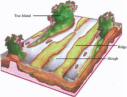
Figure 2-2. Artist’s reconstruction of the pre-drainage condition of the ridge and slough landscape. The open water sloughs are characterized by submerged and floating vegetation, including periphyton mats, and may be somewhat more sinuous than shown in the figure. The generally submerged ridges that separate them are dominated by sawgrass. The figure is approximately 1.5 miles long by 1.0 mile wide, and vertical exaggeration is on the order of 10x. Source: modified from Science Coordination Team (2003).
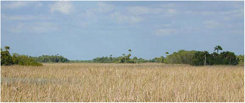
Figure 2-3. Tree islands in background with sawgrass in foreground. For a sense of scale, refer to Figure 2-2. Source: U. S. Geological Survey, available on: http://sofia.usgs.gov/virtual_tour/images/photos/alalley/tat_treeislands.jpg.
ECOLOGICAL SIGNIFICANCE OF THE RIDGE & SLOUGH LANDSCAPE
The White Paper asserts that the topographic and vegetation heterogeneity of ridge and slough landscape contributes directly to both the productivity and diversity of fishes and birds. During periods of high water, fishes use expansive ephemeral wetlands, including sawgrass stands, as foraging grounds and refugia from predation. This results in both increased reproduction and reduced mortality, leading to large increases in fish abundance. During the dry season, birds exploit the concentration of prey that occurs when these fish populations withdraw into sloughs and alligator holes (Kushlan, 1980). A growing body of scientific literature supports the assertion that wading bird use of Everglades habitats is highly dependent on these cycles in prey abundance and availability, and the microtopography that enables them (Lorenz, 2000; Russell et al., 2002; Gawlik, 2002). Current use of ridge and slough habitat by wading birds is related to the extent of microtopographic relief that remains (Bancroft et al., 2002). Generally sloughs are species- rich microhabitats (Loftus and Kushlan, 1987; Trexler et al. 2002), and their filling in with sawgrass reduces biodiversity. Tree islands are also important for nesting of alligators and roosting birds. Thus, the assertion that preservation of the ridge and slough landscape is important ecologically appears to be well grounded in science.
EVIDENCE OF DEGRADATION OF RIDGE AND SLOUGH LANDSCAPE
The White Paper defines degradation of the ridge and slough landscape in terms of both topographic and vegetation changes. The topographic changes entail a net decrease in the relief between ridge crests and slough bottoms. The vegetation changes include increases in the area of dense sawgrass and decreases in the area of open water, resulting in blurring of the directional ridge and slough pattern. Very little quantitative documentation of this landscape degradation exists, with the exception of data on tree-island loss (Sklar and van der Valk, 2003). Only recently has a detailed, comprehensive program of topographic and vegetation mapping been initiated in the Everglades. However, the White Paper provides visual evidence through aerial photographs and other imagery of pattern blurring.
In historic times, changes in water levels in the ridge and slough landscape appear to have led to changes in vegetation (Sklar et al., 2002). The lowering of water levels in some parts of the water conservation areas has led to replacement of the floating and submerged vegetation of sloughs (e.g., periphyton, a major food source for fish and invertebrates) by sawgrass and other emergent species. The raising of water levels in other areas has produced the opposite effect, “drowning” tree islands that have been impacted by fire (either human or lightning caused) and increasing the spatial extent of sloughs and their vegetation. Clearly, altered water levels and hydroperiods might have contributed to changes in ridge and slough vegetation patterns.
The White Paper asserts, however, that alteration of water levels and hydroperiods alone is not sufficient to cause the large-scale degradation of the landscape. Rather, alteration of the spatial pattern of flow magnitude and direction—associated with the construction of canals, roads, and levees and the institution of water management practices directed towards water supply and flood control—is also required. For example, extensive degradation in the water conservation areas is particularly notable near major linear structures such as Alligator Alley (Interstate 75), Tamiami Trail, and the L-67 levees and canals (Figure 2-4).
The visual evidence of ridge and slough degradation is compelling. Aerial photographs show clear differences between sites that are strongly patterned and others that are not. The association between pattern degradation and linear structures is also convincing. Furthermore, information from aerial photographs and anecdotal information indicate that the areas currently showing pattern degradation were not degraded earlier in the 20th century. It is clear that the ridge and slough landscape is degrading and that the most severe degradation is geographically associated with major linear structures that inhibit flow. (This argues against more generalized degradation mechanisms such as changes in precipitation or evapotranspiration rates in recent decades.) However, there are very few data that can be used to quantify this degradation.
POSSIBLE MECHANISMS FOR RIDGE AND SLOUGH FORMATION AND MAINTENANCE
The White Paper offers potential mechanisms for both the formation and maintenance of the ridge and slough landscape, and suggests that it is likely that several of these mechanisms act in concert. These mechanisms are summarized below.
-
The initial ridge and slough pattern could be inherited from a pattern on the underlying bedrock surface, or could have been initiated by the erosional effect of moving water over the newly-forming peat surface.
-
Differential rates of peat accumulation could be initiated by variations in microtopography that in turn lead to altered plant production or vegetation type.
-
Water flow might be required to prevent the accumulation of organic sediment in the sloughs. Accumulation leads to their degradation by effectively lowering water depth and permitting growth of emergent vegetation. Transport of organic sediment by flowing water could be continuous or highly episodic.
-
Extreme hydrologic events—hurricanes and tropical storms—would have affected the Everglades south of Lake Okeechobee to a far greater extent during pre-development conditions than now. Presently, the Caloosahatchee, St. Lucie, and other canals partially discharge these extreme flows to the sea. Although the ability of extreme flows to transport large amounts of particulates and the potential for erosion in a fragile landscape are hard to quantify, they are possible mechanisms for maintenance of the historical ridge and slough landscape.
-
Fires, which frequently occurred before alteration of the system by humans, but which are now suppressed, may have affected the evolution of the ridge and slough terrain. Fires are known to have burned selectively along the drier ridges, potentially converting them to sloughs. This reversal implies that even if the ridge and slough pattern was initiated by an underlying bedrock pattern, the two patterns may no longer be coherent. This lack of correlation is confirmed by six recent transects through areas of ridge and slough landscape (Sklar et al., 2003). In this study, in which relative elevations of the peat and underlying bedrock relative to the water surface were measured in triplicate with one-meter spacing every 50 m along the 2 km-long transects, no correlation between peat surface and bedrock elevations was apparent.
Although some of these mechanisms have intuitive appeal, virtually none has been investigated seriously. (A notable exception involves tree islands, in which tree species tolerances have been examined in the context of changes in water depth, e.g., Conner et al., 2003). Hence the White Paper makes no attempt to argue for or against any of the mechanisms. Also, mechanisms of origin and mechanisms of maintenance may differ (Box 2-1).
In the absence of a compelling mechanism, the White Paper relies on circumstantial evidence for supporting its assertion that maintenance of the ridge and slough landscape requires flow. For example, the White Paper offers ridge and slough degradation in Shark River Slough (Figure 2-4, lower left part) and Water Conservation Area 1 (Figure 2-1) as cases where degradation is not due to changes in water levels. Aerial photographs of the areas show degradation over the period between 1968 and 1984. Water-level data for the same period do not show any changes in stage. Hence the White Paper concludes that the degradation must be due to changes in flow.
It is probable, however, that water levels did change as a result of the creation of the water conservation areas in the early 1960s, although there are no data to document this change. Since noticeable ridge and slough degradation presumably requires years to decades to occur after changes in water levels, these pre-1968 water level changes also may have played a role – even if not the primary one – in the degradation.
The White Paper makes a more general argument for the importance of flow based on the alignment of flow and the landscape pattern. All available evidence indicates that the ridge and slough landscape is generally aligned with the pre-disturbance pattern of flow. For example, hydrologic simulations using the Natural System Model (NSM) and based on inferred topography make a strong case for this alignment. (Since ridge and slough features are not resolved by the NSM, the simulations are not artifacts of the features.) Based on the NSM simulations, under equilibrium pre-disturbance conditions, large quantities of water moved over the landscape each year. In many years this water was the result of local rainfall. In wet years, however, additional water would have spilled from the southern edge of Lake Okeechobee, spread uniformly over the relatively featureless sawgrass plains, and then flowed through the ridge and slough landscape (with some escaping to the east through coastal channels). Given the relative flatness of the peat in the east-west direction perpendicular to flow, the flow through both the sawgrass plains and the ridge and slough landscape must have been uniformly distributed across the full width of the flow path (except, of course, for the local concentration of flow in the sloughs). This pattern of flow would have persisted over the several thousand-year history of the Everglades (Gleason and Stone, 1994) as the ecosystem developed.
Hence the White Paper argues that, as with many wetlands, flow probably plays a “vital role” in the ridge and slough ecosystem, and that maintenance of this ecosystem requires some degree of maintenance of the associated flow regime, even if the details are not understood. This report concurs with the White Paper’s conclusion, even though this is largely based on experience and judgment rather than on the results of process-based research.
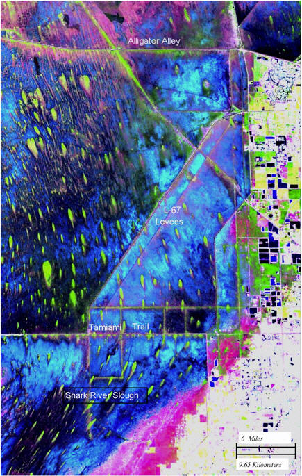
Figure 2-4. Detailed image of the ridge and slough landscape. The light teardrop-shaped areas are tree islands. Note the shift in alignment of the tree islands south of the Tamiami Trail where the direction of flow also changes. SOURCE: Florida Satellite Image, section 22, of South Florida Water Management District, accessed online at http://www.evergladesvillage.net/sat/everglades/.
|
BOX 2-1 ORIGIN OF THE RIDGE AND SLOUGH LANDSCAPE The White Paper recognizes that the conditions responsible for the development of the ridge and slough landscape may be different from those responsible for its maintenance. This committee concurs. For example, ridge and slough landforms may have been initiated by preferential formation of peat in bedrock depressions as peat deposits were first forming in the Everglades 5000 years ago. As these deposits mounded above the surrounding bedrock, they would have diverted flow. Peat may have preferentially accreted downstream of the mounds, thereby causing the mounds to elongate. Over time the system of elongated mounds and intervening depressions then may have evolved into the present system. Under this model, once the ridge and slough pattern became established, the bedrock would not be a factor in maintaining the pattern. (This does not appear to be the case with tree islands that have bedrock at the head.) The absence of ridge and slough landforms in the sawgrass prairie south of Lake Okeechobee is consistent with this hypothesis. When wetlands first formed in this area about 5000 years ago, overflow from the lake was likely diverted around them by the bedrock Loxahatchee Channel (a broad topographic low area in the bedrock draining to the east and southeast). As a result, the initial deposits consisted of calcitic mud, which blanketed the bedrock surface south of the lake and which undoubtedly reduced surface heterogeneity. (Modern calcitic muds are associated with periphyton, and form in place of peat if the period of inundation is relatively short. Without Lake Okeechobee as a source of water, the hydroperiod in the region would have been relatively short compared to the hydroperiod in the Loxahatchee region.) After the Loxahatchee Channel filled with peat and Lake Okeechobee began flooding the sawgrass prairie region, there may have been no irregularities to trigger the formation of peat mounds and initiate the formation of ridges and sloughs. |


