
4
Opportunities to Enhance the Road Weather System
Many of the building blocks for creating the road weather system of the future are available today. Chapter 3 of this report summarizes the capabilities and technologies that are already being applied to road weather problems or that could easily be used. However, fully achieving the vision for a highly effective road weather system will require the research and operational communities to address a number of gaps in existing knowledge and infrastructure. These gaps at least partly reflect the lack of integration between ongoing surface transportation and meteorological activities. Thus, the committee recommends that a focused and coordinated national road weather research program be established to provide leadership in defining priorities, supporting the necessary research, and implementing operational infrastructure. With an improved overarching direction for the road weather community, there are substantial opportunities to produce improved products of interest to the user community through increased coordination of efforts (e.g., Nixon, 2001). At the same time there is a need to address fundamental scientific unknowns and make required observations that have been lacking.
As a framework for this program the committee identifies the following five key research and development requirements:
-
a robust, integrated observational network and data management system specifically designed to meet the need for enhanced road weather research and operational capabilities;
-
a coordinated research effort to increase understanding of road weather phenomena and options for increasing safety, mobility, and efficiency of the nation’s roadways during all types of weather;
-
improved modeling capabilities and forecast tools designed to provide relevant, useful information to those who build, manage, maintain, and use the nation’s roadways;
-
multiple mechanisms for communicating road weather information to varied users in ways that support better informed decision making; and
-
an infostructure that takes advantage of new technologies to effectively monitor and predict road conditions and then effectively convey road weather information to end users.
Opportunities for improving understanding, capabilities, and products in these areas of a new road weather research program are discussed in the following sections. The committee believes that advances in each of these areas will be necessary to attain significant improvements in road weather services and the benefits that are expected, as a result, in safety and efficiency on the nation’s roads.
Coordinating this body of work will require a management structure that engages the multifaceted “road weather community.” This community includes FHWA, NOAA, departments of transportation in each state, an important and vigorous private sector, the academic community, and professional societies (e.g., the American Meteorological Society) and other nongovernmental organizations (e.g., the American Association of State Highway Transportation Officials). One role of a national road weather research program would be to coordinate research, development, and implementation efforts undertaken by the various members of this road weather community. The recommendations in this chapter identify specific research needs that a new road weather research program should address, though in many cases the actual research, development, and implementation will fall to various members of the broader road weather community. Issues pertaining to management of a national road weather research program are addressed in Chapter 5.
OBSERVATIONS
A major objective of a new road weather research program should be to develop a robust, integrated observational and data management system specifically designed to meet the need for enhanced road weather research and operational capabilities. Many of the other objectives of the research program will depend on having implemented a road weather observation system, broadly defined; for example, improvements in understanding of road weather phenomena, modeling capabilities, and products and tools for end users require appropriate observations.
This road weather observation system should bring together a wide variety of existing data streams and new data as necessary to obtain a
comprehensive picture of the roadway environment. Table 4-1 lists many of these observations. Several of the meteorological observations are currently used in an integrated fashion by weather forecasters and as input to numerical weather models. Other data, particularly those collected by the transportation community, are not yet integrated to the same extent or in a routine or standardized manner. Improved data management that enables efficient data sharing will be an important component of an improved road weather observation system.
Take Advantage of Existing Observations and Databases
As shown in Table 4-1, numerous observation networks are already available for assessing road weather; for example, many states have installed environmental sensor stations (ESS) along roadways to obtain targeted road weather observations. Data from ESS are essential to detecting and forecasting the effects of weather events on the roadway; however, they fall significantly short of the total amount of weather information needed to do this job well. The ESS data should be augmented with weather information from weather satellites, Next Generation Radar (NEXRAD) national radar network, surface sensors in other networks (e.g., Automated Surface Obsreving System (ASOS), aviation, agriculture, energy, water resources), vehicle probes, and weather data that can be derived from global positioning system satellites (e.g., see http://www.cosmic.ucar.edu).
Bringing all these data sources together allows a much more comprehensive picture of the roadway environment to be derived and used to provide information to drivers, roadway managers, and researchers. New technologies are rapidly emerging to assimilate data from disparate sources, but very little has been implemented to directly benefit road weather. Some private sector companies have pioneered the process of aggregating weather data from ESS and other weather observing networks to prepare targeted road weather forecasts.
In the case of winter road maintenance, data must become targeted specifically to the microclimate existing at or near the pavement surface. To accomplish this, sensor needs change significantly, and integration of other information, such as recent surface treatment history (e.g., plowing, sanding, and chemical application), become important factors. Treatment history collection and availability vary widely, but most of the larger state transportation agencies keep some type of records on time, equipment, and chemicals used in maintaining roads during snow and ice conditions. Methods for recording this information range from having operators manually record it to entering by means of computers when they input their duty time.
At the Minnesota Department of Transportation, for example, individual operators input this information along with their duty times using a Webbased application. Information on individual routes—including time expended, equipment and materials used—allows managers to analyze past actions, plan for future events, and determine whether current strategies are producing the desired results. Research in the areas of Automated Vehicle Location systems and Web-enabled cell phones is allowing road treatment and condition information to be reported more frequently. In the future it may become common practice to have in-vehicle equipment installed on snowplows to continuously measure and report this information.
Another untapped source of information are data on the characteristics of the surface and subsurface of the roadway that most state departments of transportation collect and retain during roadway planning and construction. This information is updated each time any construction or repairs are performed. Data on the road surface and subsurface composition are valuable inputs to pavement temperature models, in which the heat balance is affected by what is under the surface as well as what is above it. Research must be done to determine how changes in this profile affect the road surface and what would be the most efficient way to use this information to obtain more accurate pavement forecasts. Although many departments of transportation store this information in electronic format, they frequently identify it by mile posts, centerline distance, or stationing, which is significant only in its relationship to that particular road. In addition, different layers are identified by a numerical code that may be unique to that agency. If this information were to be used by an outside agency or vendor or shared among states, it would have to be converted to a geographic information system (GIS) format and layers identified with standard codes.
A final set of observations that could greatly enhance the road weather system is average and real-time traffic information. Data such as the average number of vehicles and average vehicle velocities, as well as real-time values of these parameters, are useful for strategic planning and reactive purposes. The speed and volume of vehicles influences the heat and moisture balance of roadways as well as their operability. These factors change diurnally (e.g., rush-hour traffic, early-morning hours), intra-annually (e.g., during prime vacation travel times), and during special events (e.g., concerts, sporting events). All departments of transportation have some type of statewide traffic-data-recording system composed of a remote-sensing system (i.e., pavement loops) and a data recorder that is used for monitoring and assessing traffic volume and speed characteristics (Wolshon et al., 2001). Surveillance cameras also monitor speed and volume, with direct visual confirmation. As with other previously mentioned observation net-
TABLE 4-1 Existing and Potential Observations That Should Be Applied to Road Weather Research and Operations
|
Observation |
Description |
Operated By |
Road Weather Application |
Limitations |
|
Automated Surface Observing System |
About 1,000 surface sites providing observations of sky and visibility, pressure, temperature, dewpoint temperature, wind, and precipitation amount |
• Federal Aviation Administration • Department of Defense • National Oceanic and Atmospheric Administration/National Weather Service |
Provides weather observations used as input to numerical weather prediction models to ascertain real-time weather conditions on a mesoscale basis and aid in weather forecasting |
• Observations are representative of small area directly adjacent to site • Mostly sited to meet aviation requirements • Lack of good winter precipitation observations |
|
Automated Weather Observing System |
Over 600 surface sites providing observations of wind data, temperature, dewpoint temperature, visibility, present weather, precipitation, cloud height, thunderstorms, and lightning |
• Federal Aviation Administration • State, local, and private organizations |
Provides weather observations used as input to numerical weather prediction models to ascertain real-time weather conditions on a mesoscale basis and aid in weather forecasting |
• Observations are representative of small area directly adjacent to site • Mostly sited to meet aviation requirements • Lack of good winter precipitation observations |
|
Various surface mesonets |
Similar observations as ASOS operated on a regional basis with higher density of sites |
• Oklahoma Mesonet • Atmospheric Radiation Measurement Cloud and Radiation Testbed • Many others |
Provides weather observations used as input to numerical weather prediction models to ascertain real-time weather conditions on a mesoscale basis and aid in weather forecasting |
• Observations are representative of small area directly adjacent to site • Sited to meet needs of specific mesonets • Data are not always easily accessible across mesonets • Lack of quality control and standards |
|
Environmental Sensor Stations |
A complement of atmospheric sensors adjacent to the roadway (air temperature and dew point, wind speed and direction, and optionally, pressure, precipitation occurrence, other precipitation |
Individual states or municipalities |
Provides most direct observations of roadway environment |
• Observations are representative of small area directly adjacent to site • Individual networks are not linked • Insufficient standards for instruments and siting |
|
Observation |
Description |
Operated By |
Road Weather Application |
Limitations |
|
|
characteristics and visibility), pavement surface sensors (temperature, moisture, residual chemical composition, freeze point temperature), and sub-surface temperature probes |
|
|
• Improvements in instrument technology needed |
|
Aircraft Communication Addressing and Reporting System |
Observations of temperature, humidity, and wind collected on commercial aircraft up to 15 km altitude |
Aeronautical Radio, Inc. |
Input to numerical weather prediction models and as aid in weather forecasting |
Not directly relevant to the roadway environment |
|
In situ observations from vehicles on the roadway |
Observations of air and surface temperature, humidity, surface friction, and visibility in the roadway environment |
Some prototypes being developed and tested, but not yet operational |
• Information provided directly to drivers • Input to road weather forecasts • Input to numerical weather prediction models |
• Challenges in communicating observations • Possibility for more observations than can be usefully applied |
|
Weather radars, including NEXRAD |
Nearly continuous monitoring of precipitation, including severe weather, and an ability to determine winds and detect blowing dust |
• National Weather Service • Federal Aviation Administration • Private sector, including television stations • Military |
Input into numerical weather prediction models (e.g., the Weather Research and Forecasting model) |
• For NEXRAD, scans below 0.5° above horizon not permitted so areas distant from radar not well monitored • Network not very dense • Cannot discriminate precipitation phase (liquid or frozen) • Excessive ground clutter contamination from anomalous beam propagation • Conflicting user requirements |
|
Observation |
Description |
Operated By |
Road Weather Application |
Limitations |
|
Wind and temperature profilers |
Remotely sensed observations of temperature, moisture, and wind up to 16 km above the surface |
• National Oceanic and Atmospheric Administration • Other state and federal agencies • Academia • Private sector |
• Input into numerical weather prediction models • When combined with SODARS, the 900-MHz band profilers can be used for microscale modeling of the roadway • Improve weather forecasts |
• Representative of a small area • Network not very dense |
|
Geostationary Operational Environmental Satellite, Polar Orbiting Environmental Satellite, and other satellites |
Observations at multiple wavelengths (e.g., visible, infrared, microwave) used to derive, for example, integrated water vapor and cloud-track winds, tropical cyclogenesis |
• National Oceanic and Atmospheric Administration • National Aeronautics and Space Administration • Military |
Improve weather forecasts |
Cannot resolve features on the roadway |
|
Traffic observations |
Traffic detectors and cameras |
Individual states or municipalities |
• Managing the traffic system during inclement weather • Input to energy balance models • Study of weather impacts on traffic |
• No standard format or reporting procedure • Expensive to store |
|
Recent treatment history |
Data record indicating the chemical application, plowing, or sanding of a given stretch of roadway |
Individual states or municipalities |
Input for forecasting road surface conditions and providing decision support for further treatments |
No standard format or reporting procedure |
|
Roadway surface and subsurface |
Surface and subsurface sensors used to measure temperature |
Individual states or municipalities |
Input for energy balance models that forecast road surface temperature |
Network not very dense |
|
Observation |
Description |
Operated By |
Road Weather Application |
Limitations |
|
Streamflow |
Measurement of the movement of surface runoff traveling in a stream |
• U.S. Geological Survey • National Oceanic and Atmospheric Administration • Others |
Useful for forecasting floods |
Network not very dense |
|
Landsat |
Land surface cover/land type |
National Aeronautics and Space Administration |
Input for energy balance models that forecast road surface temperature |
Maps and data require some user interpretation |
|
Global Positioning System |
Satellite-based system to show position on Earth’s surface; can also be used to derive total water vapor column |
Department of Defense operates the satellites; receivers are widely available |
• Useful for providing targeted geolocated information • Derived water vapor useful for improving weather forecasts |
Selective availability leads to degraded accuracy in position readings |
works, if traffic data are to be used by other agencies or vendors, standards for displaying the information must be established.
Recommendation: Take advantage of existing observation networks and databases.
The committee recommends that the road weather research program take full advantage of established environmental monitoring networks, including those from in situ and remote-sensing platforms and existing databases on soil type and land use characteristics. As a first step, efforts are needed to integrate and use information from environmental sensor stations and meteorological mesonets with particular attention to seamlessness across state boundaries. A nationwide repository in which weather observations relevant to the roadways are collected and shared by all interested parties would be of great use to the road weather community.
The committee recommends that the road weather research program support the design and establishment of a portal that allows access to (1) weather data relevant to the roadway; (2) state databases of relevant road characteristics, including pavement or concrete composition, road surface depth, and underlying soil type; (3) real-time road surface condition information; and (4) traffic information. Access to these data currently is constrained by the limited data availability and disparity of data formats used by states and municipalities. Having access to these data in standard formats would allow private sector companies to develop forecasting tools that could be easily and reliably applied in different states.
Expand the Network
Exploiting weather information to increase the efficiency of the roadway system requires weather, road condition, traffic, and other observations that are representative of the roadway. Additional observations are required at locations especially susceptible to adverse weather conditions, such as valleys where fog often forms, frost hollows, or roadways subject to high winds. Over the last 20 years most states have implemented ESS networks to collect valuable weather data in targeted locations. At the same time, various meteorological observing networks have been established to meet general weather forecasting needs, as well as those of more specialized sectors, such as aviation, forestry, or agriculture. These observational efforts must be expanded and customized to fully meet surface transportation needs by collecting tailored information along the roadways, particularly at vulnerable locations susceptible to adverse weather conditions; for example, the National Weather Service (NWS) should consider road weather needs in planning new observation sites.
Although Road Weather Information Systems (RWIS) technology has been used for many years, research is needed to make optimal use of it; for example, only a few states have attempted to determine optimum sensor density. RWIS companies have recommendations for spacing of the sensors, but in most cases they are based on regional or national average estimates rather than site-specific analyses. Given funding limitations, roadway managers need refined methods to prioritize sensor locations in the network. A science-based method allows the determination of which sensors give the operator the largest value for the investment costs. Roadway managers also need methods of determining where to locate sensors, such as the optimal height above the road surface, distance from the roadside, or placement in
the road surface; for example, in some cases it might be more advantageous to locate a sensor far from the roadway to detect weather conditions that influence that segment of the system.
Tapping into the data from vehicle probes would vastly increase the number of observations available for the roadway, much the way observations from aircraft have been exploited. Although the technology is already available, it is not used routinely. Commercial fleets represent an excellent opportunity for experimentation and evaluation of these data because they provide a representative sample from a manageable amount of data with tighter institutional control.
Observational technology ranging from soil and pavement sensors to universal vehicular highway reporting is possible, providing exciting opportunities for expanding knowledge of the roadway environment; however, determination of what is to be measured, and where and when, are challenges. Research is needed to explore the quantity and accuracy of data needed for mesoscale forecast models, decision systems, and highway maintenance personnel. Who will do the research and where it will be conducted also must be explored.
Recommendation: Improve the existing observation system.
To attain an improved road weather observation network the road weather research program should support efforts to establish standards for observing procedures and station siting to ensure that (1) the data are representative of the roadway environment and (2) new road weather stations and traffic monitors are added to optimally address both modeling and special observing needs. The National Weather Service, states, and other entities that perform weather observations should use these standards as they establish new sites to fill gaps in the current observational network.
In addition to improving fixed road-weather-observation sites, expanded use should be made of mobile observing platforms. Such platforms could consist of a fleet of state- or city-owned vehicles, commercial trucks and buses, and even private vehicles. Vehicle observations of roadway temperature and surface traction could be of great use in providing a more complete and accurate picture of roadway conditions. The road weather community should collaborate with the automobile industry in the design and deployment of these mobile observing platforms and ensure that these data remain open to access.
Instrument Technology
A final way to ensure robust observational capabilities is to make certain that the instrumentation provides high-quality, accurate data. Careful testing and calibration of sensors is an important step in improving instrumentation. Although testing and calibration standards have existed for atmospheric sensors for some time, current sensors, sensor standards, and instrument placement are tailored to meteorological needs and, in many cases, do not meet the specialized needs of maintenance, traffic, and emergency managers. For instance, precipitation sensors must be capable of accurately identifying precipitation type and amount as well as the liquid equivalent through all temperature ranges.
There currently are no standards for surface and subsurface environmental sensors. More concerted research is needed to test and compare the pavement sensors. To deliver the accuracy and response time required by sensor users, close attention must be paid to sensor design, installation, and calibration. This is needed to ensure that the thermal properties of the surrounding pavement are accurately represented by the sensor.
The majority of research and development of environmental sensors takes place in the private sector, which has led to new and improved sensors being offered by multiple companies; however, most of these sensors have not been rigorously tested and compared, meaning that it can take many years to design and get funding for an experiment that tests the sensors in a real-world setting, and then run the experiment long enough to get sufficiently representative weather conditions. By the time a research group has undertaken all of these steps it is likely that the sensors being tested will be outdated. An additional problem for testing pavement sensors is the difficulty of creating a controlled experiment as roadway maintenance engineers prefer to treat the roadway when called for. As a result, insufficient information is available to consumers when choosing which sensor to purchase. To date, environmental sensor users have relied almost exclusively on accuracy, installation, and calibration information provided by product manufacturers. While this information can be useful (e.g., Partanen et al., 2003), it is often produced in controlled laboratory or test-bed conditions, and therefore can be far removed from real-life conditions that affect sensor performance. There are currently two projects under way to test environmental sensors in an operational setting: (1) Aurora project 2001–2004, Temperature Sensor Accuracy, and (2) an Aurora-initiated project that has now developed into National Cooperative Highway Research Pro-
gram Project 6-15, Testing and Calibration Methods for RWIS Sensors. Although both of these projects represent a move in the right direction, pavement sensing is a continuously developing field, and a structured test and evaluation procedure needs to be developed and administered on an ongoing basis.
In addition to the need for improved testing of existing environmental sensors, improved sensor technology specific to road weather applications must be developed. In particular, environmental sensors must be robust, reliable, and accurate under a wide variety of weather conditions. Research is needed to develop improved techniques for measuring quantities of special relevance to road weather applications, such as the amount of ice, precipitation, and chemical treatment on the road surface.
Of particular concern is that current pavement sensors are limited in their spatial representativeness, in their ability to function in all moisture conditions, and in the assumptions made in signal processing. Presently there are several different pavement sensor technologies in use or being developed. Some of these include fiber optics, active sensors, resistance, spectral cameras, and even analysis of photos from still and video cameras. While each of these methods has merit, they all have weaknesses that must be more thoroughly understood in a field environment; for example, sensors measuring chemical concentration on pavement function with a reasonable degree of accuracy only when there is plenty of moisture on the road surface. Under dry conditions passive sensors cannot distinguish different types of chemicals or surface contaminants, and active sensors change the environment surrounding them, sometimes enough to affect these measurements. To be truly effective in making equipment control decisions during frost or other low moisture conditions, pavement sensors need the ability to measure when little or no moisture is present.
Besides changes in sensor technology, research is needed to improve information processing capabilities in environmental sensors. In most cases raw information collected from a sensor undergoes some processing in the field before it is reported, however the processor technology does not seem to have advanced far enough to fully meet user needs at this time. Pavement sensors hold great promise for significantly expanding the spatial coverage of observations and thereby act as an important constraint in models of road conditions; however, these instruments may require substantial research and development to attain required levels of accuracy and reliability.
Recommendation: Improve road weather instrumentation.
The road weather research program should support efforts to establish science-based standards for road weather sensors and to implement procedures to test, compare, and certify that sensors meet these standards. The comparison and testing procedures need to ensure that the results are applicable to a field setting. The committee recommends support for the development of improved sensor technology specific to road weather applications, such as for the amount of ice, all-season precipitation, present weather, and chemical composition of the slurry on the road surface. Research is needed on design and deployment of sensor systems to provide data more generally representative of the traveled road surface and that are reliable under a wide variety of weather and traffic conditions.
Data Quality Control, Dissemination, and Archiving
Systematic quality assurance, dissemination, and archiving of road weather data are fundamental steps to making progress on all the recommendations made here. Some types of data must be collected at the time of road construction (e.g., soil type and road construction materials) and archived as a semipermanent database, and updated during renovations. Other forms of data (e.g., change of land use along the roadway) need periodic updating within the database. On the other hand, collection of real-time data leads to a very dynamic, ever changing database. The utility of road weather data would be enhanced if the data were easily accessible in common data formats and geolocated to the extent possible (Reichardt, 2003). Many state departments of transportation are already taking advantage of GIS in storing road composition data, but this is not yet standard practice in the meteorological community (Wilhelmi and Brunskill, 2003). An encouraging development is the NWS designing the National Digital Forecast Database to be GIS compatible. This will greatly increase the value of these forecasts for both direct use and private sector partners.
Quality assurance is essential for data reliability and accuracy. Much of quality assurance can be handled automatically, with checks performed continuously on the data stream. Periodic automatic scans of datasets using statistical tools can identify longer-term trends indicative of instrument drift; however, careful visual scrutiny of data displayed either as time-series graphs or as two-dimensional data fields by an experienced analyst is still an
essential part of quality assurance. Quality control supported by field maintenance teams and calibration laboratories is a necessary extension of the quality assurance program.
A dissemination program ensures that data necessary for research or operations are provided when and where needed. Often research programs can be satisfied by providing researchers direct access to the database (a “pull” situation), whereas operations often require that specified data be sent to them (a “push” operation). Data portals, providing easy access to data stored in a variety of formats, often at different locations, are a growing trend but require significant investment in professional time and technology to establish. A particularly demanding criterion in providing real-time data is latency, or the time lapse between taking a measurement and providing the resulting value to the user. Some applications (e.g., warning of severe weather events) have latency demands of a few seconds.
There are many state, regional, and national programs undertaking the challenge of merging available observations and disseminating the information in a timely, meaningful, and easily interpretable format. One such program is the Meteorological Assimilation Data Ingest System operated by the National Oceanic and Atmospheric Association’s (NOAA) Forecast Systems Laboratory. This system collects surface, profiler, upper air, and aviation data (Figure 4-1) from meteorological networks, both public and private, for North and Central America (Miller and Barth, 2003). Data are processed continuously at five-minute intervals and can be acquired by interested user groups over the Web (http://jailbird.fsl.noaa.gov/MADIS/). A new proposal, the Sensor Web (Reichardt, 2003), provides an opportunity to collect and make available multisource, formatted sensor data to scientists, traffic managers, disaster managers, and others. This appears to be a viable opportunity to collect the high volume and varied types of data that are or will be available.
Archiving of data requires not only storage in readily accessible form of the data itself, but also of the accompanying metadata. Metadata provide the history of data and are a dynamic quantity in their own right. Records can contain both descriptions of the data formats and a wide range of information, such as sensor calibration history, exposure imagery, and records on how frequently the data are used and by whom. Management of a data archive is a technical challenge as the data must be secured against physical hazards and unauthorized changes but still be readily accessible. An additional archival challenge is forward migration of large databases as the storage medium is upgraded.
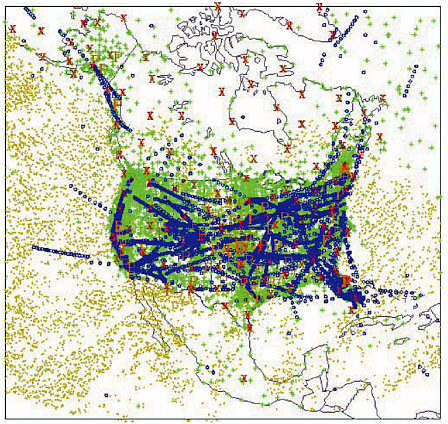
FIGURE 4-1 Meteorological Assimilation Data Ingest System observations available in North America. Green represents surface data, blue represents aircraft data, red represents radiosonde data, and the yellow “P” represents profiler data. SOURCE: NOAA’s Forecast Systems Laboratory.
Recommendation: Maximize utility and quality of road weather information.
The committee recommends that the road weather research program take steps to maximize the utility and quality of road weather information. First, to facilitate sharing among multiple entities, the road weather community should help standardize formats of geolocated data and associated metadata (e.g., the National Transportation Communications for Intelligent Transportation System Protocol for Environmental Sensor
Stations). Second, the community should standardize the presentation of road weather information (e.g., in terms of units, colors, or symbols) to user groups across North America. Third, to facilitate integration of information from different research communities, the community should use geographic information systems to analyze, manipulate, and display road weather observations, model output, and forecasts. Fourth, the community should establish standards and implement data quality assurance and control procedures. It is critical to ensure that all road weather observations are of sufficient quality to be used in the numerous desired data applications.
Observations and Infrastructure for Validating Models
Specific observational data also are needed to validate and improve both road and atmospheric boundary layer models. In addition to exploiting untapped data sources and expanding current observational capabilities, separate sustained support is needed for establishing an infrastructure to obtain observations specifically for both model and road weather forecast validation. Ideally as many validation systems as possible should be deployed, but at a minimum they should be located along the national demonstration corridors (see Chapter 5, “Establish National Demonstration Corridors”) and possibly in conjunction with regional research centers (see Chapter 5, “Establish Regional Research Centers”).
To capture the diverse roadway environment that exists across the nation, the observational facilities should be located along roads with various types of land cover, terrain, and uses. In some cases these facilities should consist of permanently instrumented arrays in key areas that should be routinely maintained and operated. These core networks should provide the long-term data records necessary to investigate a number of road weather challenges. In addition to the permanent arrays, instrumentation is needed for rapid deployment for occasional intensive observation periods. To be cost-effective the deployments should likely occur in and be complementary to the permanent arrays. The platforms should cover a sufficient area and depth to be representative of both the roadway and the environment on either side. Where possible the facilities also should be augmented by existing mesonet facilities to obtain even more data and further increase cost-effectiveness.
The most important parameters that should be recorded at all observational facilities are temperature, precipitation amount and type, wind speed and direction, relative humidity, insolation, pavement temperature, road
surface cover, and surrounding surface cover. The data from these observational facilities should be of sufficient temporal resolution (e.g., data collection as frequently as every minute) to provide a sufficient amount of data and to capture rapid environmental changes. These specialized arrays will facilitate the evaluation and improvement of road weather models and forecasts.
Recommendation: Develop observing capabilities to measure the performance of road weather forecasts.
The committee recommends that the road weather research program develop special observing facilities to validate forecast tools and verify road weather forecasts. Ideally, these observing facilities would be located along the national corridors and at the regional centers identified previously. In some cases these facilities could consist of permanently instrumented arrays, but to be cost-effective most should consist of supporting infrastructure that facilitates the rapid deployment of instrumentation for occasional intensive observation periods. An important aspect of the recommended work would be the collection of micrometeorological measurements necessary to develop, improve, and validate the models.
ADVANCING THE SCIENCE AND DEVELOPING THE TECHNOLOGY
The national road weather research program will need to coordinate and support efforts to increase understanding of road weather phenomena and options for increasing safety, mobility, and efficiency of the nation’s roadways during inclement and other high-impact weather. Because little research has been conducted specifically on these issues to date, targeted support of research on the road weather environment could potentially yield substantial returns in understanding and consequently managing the roadway system. Areas of meteorology where increased attention to the roadway environment is needed include boundary layer meteorology; weather-influenced phenomena that impact roadway transportation, such as flash floods and fires; and the development of a reliable winter severity index. Several aspects of transportation research would benefit from increased attention to weather, such as quantifying how weather affects traffic, human factors associated with driver behavior during inclement weather, and improvements in vehicle technology to better equip drivers to respond to weather conditions. These topics, discussed in more detail in the follow-
ing sections, are those that the committee believes require increased attention initially; they do not, however, represent an exhaustive list of basic research needs. Indeed, as the research program is established and grows, the research must evolve to meet changing needs.
Meteorological Phenomena That Affect the Roadway
Micrometeorological processes that occur near the bottom of the atmospheric boundary layer, which is the layer of air that directly feels the effects of the ground surface, can be quite complicated and make it difficult to analyze weather along roadways. On sunny days the boundary layer is roughly 1 to 2 km deep and is formed by turbulent mixing of air currents rising from the warm surface and compensating downdrafts. At night the boundary layer is much shallower. During both day and night, vertical gradients in wind, temperature, and humidity are concentrated near the surface, and observations of atmospheric conditions even 2 to 5 m above the surface may not capture the conditions that affect driving and the road surface. To understand the effects of the surface on the atmosphere, particularly at scales relevant to roadways, micrometeorologists often must account for the effects of canopy, terrain, natural and built structures, surface vegetation, and soil characteristics (see Figure 4-2); for example, the wetness of the ground affects the partition of solar energy into evaporation and heating, whereas natural and built structures can alter heating and cooling through radiative processes and can deflect or channel the wind.
Significant research challenges remain in understanding and predicting micrometeorological influences on temperature in the roadway environment. Nocturnal cooling, for example, can strongly affect the roadway environment. On nights with light wind and clear skies, the ground cools rapidly by radiating heat to space and then cools the shallow layer of air immediately above by contact. On a slope, this cold air nearest the ground slides downhill because it is heavier than the air at the same height further out into the valley. These down-slope winds are reinforced by flow from the valley sides and continue down the valley, eventually forming pools of cold air in the valley floor (Figure 4-3). Even in gentle valleys, air can be as much as 10°C cooler than the air on the ridges. Cooling in depressions protected from the wind and wind-induced mixing (“frost hollows”) can be even more significant. In both cases the low-lying areas will be most susceptible to fog or frost.
Nearby obstacles and terrain further increase the complexity of the road weather environment. Trees, bluffs, bridges, and buildings can deflect and
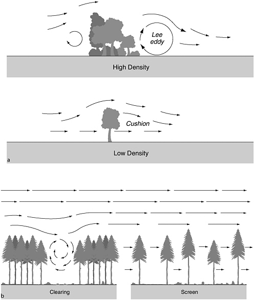
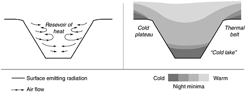
FIGURE 4-3 Development of a frost hollow in a depression. SOURCE: Geiger et al. (1995).
funnel wind, potentially causing drifting snow and unpredictable, hazardous gusts. Heat exchange between the road surface and the atmosphere is complicated by the heterogeneity of the road surface and its nearby environment. This environment is complicated further by the traffic itself, which introduces heat, mixes air, splashes fluid on the road, and reduces the radiative warming and cooling of the road surface.
The importance of local effects to the roadway environment suggests a two-step approach to simulating road weather conditions: (1) running atmospheric models with land surface data (except for ESS data from stations sited to document nonrepresentative effects) to solve the future state of the atmosphere at scales down to 5 to 10 km; and (2) using that future state of the atmosphere along with the road information (pavement and near-road environmental sensors) to produce road surface temperature and road condition forecasts. For roads in flat terrain and fairly uniform environments, idealized models that characterize the exchanges of heat, moisture, or momentum between the air and the surface can be useful. For roads in complex terrain one must resort to higher-resolution atmospheric models with detailed surface characteristics or to empirical techniques to successfully capture the fine-scale variability.
Another micrometeorological research challenge is the observation and forecast of conditions that reduce visibility, such as fog or blowing snow. Although many fog-prone stretches of road are known locally, there has been relatively little research on the fog problem specific to road transpor-
tation. No one has succeeded in the operational modeling of the development of radiation fog. Similarly, enough is known about how snow accumulates in certain areas to install snow fences to mitigate snow accumulation on the road, but less attention has been paid to loss of visibility from falling or blowing snow, or slush splashed on windshields by passing traffic.
Research is needed to improve visibility detectors. Currently available visibility sensor equipment takes samples over a very short distance or baseline (1 to 3 feet) and assumes this to be representative of the entire area. Clearly this assumption is not always valid because visibility in fog, snow, blowing dust, and other inclement weather conditions, tends to vary greatly over short distances. One possible means of achieving a more representative measurement is through analysis of video frames or still images. While there has been some research done in this area, the technology has not been commercialized and is not available for use at this time. Care must be taken to seek instruments that measure low visibility specifically under all lighting conditions.
Weather-Influenced Phenomena
Many weather-induced hazards, such as flash floods, fires, avalanches, snowdrifts, rock falls, mudslides, and other debris flows, rapidly impede roadway use. Many of these hazards are in regions with sharp regional and local gradients in weather and climate behavior; for example, an avalanche may flow over several thousand feet of vertical distance before reaching a roadway and then affect only a small length of the road where it crosses. The region in which the avalanche began may have completely different weather conditions than where the avalanche covers the roadway (Figure 4-4). Thus, not just the roadway conditions require monitoring and forecasting but all of the regions that either directly or indirectly affect the roadway. Research is needed to improve both observing and forecasting these hazards and how best to respond to them.
Observational, forecasting, and emergency response capabilities vary from region to region. Most NWS offices have service hydrologists on staff; many counties, towns, and cities have active search and rescue teams; some regions of the country have avalanche prediction, research, and warning centers. Many universities, private companies, and government agencies are investigating weather-influenced hazards with new and improved simulation and modeling research, improved sensing and measurement technologies, and merging of hydrometeorological data. To effectively implement this research for use in the roadway environment requires (1) an
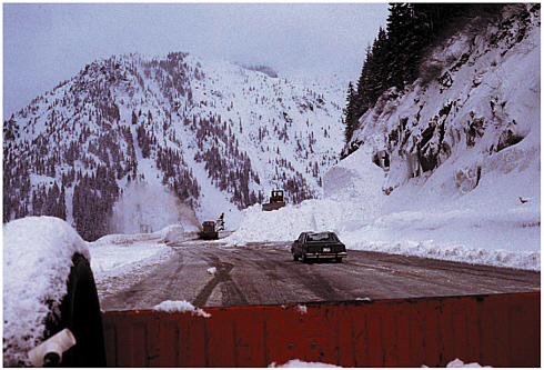
FIGURE 4-4 Removal of avalanche debris along US-2 in Washington. SOURCE: Northwest Weather and Avalanche Center, Seattle, Washington.
operational focus; (2) information that is easy to implement and use; and (3) weather liaisons between the research and development entities and the practical application by users.
A number of significant gaps should be addressed in order to improve the forecasting and warning of these weather-related roadway hazards. First, research is needed to improve the understanding of the causes of these hazards. Second, efforts are needed to (1) improve sensing and measurement technologies (e.g., snow depth, precipitation, mountaintop winds); (2) develop the ability to combine various types of hydrometeorological data; and (3) facilitate sharing of real-time data and products among entities. Using a GIS-based system, “smart maps” should be created for hazard regions across the country that contain information such as roadways, potential weather-related risks, and weather information. Eventually, improved simulation and modeling of these weather-influenced incidents can be used to develop improved site-specific forecasts for weather-induced hazards that could be incorporated into these smart maps. Finally, emergency responses to these events require proper coordination, as many agencies may be involved.
Recommendation: Improve prediction and warning of weather-influenced hazards that rapidly impede roadway use.
The road weather research program should support research to improve predictions and warnings of weather-induced hazards that rapidly impede roadway use, such as flash floods, avalanches, mudslides, and other debris flows. Better understanding of the causes of these hazards and how best to respond to them could help avoid loss of life and property. Existing observational and forecasting capabilities need to be assessed and significant gaps should be addressed.
Winter Severity Index
Winter weather indexes have been developed in several states as a means to normalize the classification of weather events and the environment in which they occur. Similar indexes have been developed for the accumulated effect of storms through an extended period of time or season. One such winter weather index is a multipurpose tool that determines the relative severity of winters and enables practitioners to determine the efficacy of their responsive operations. It can be used to (1) estimate winter maintenance costs for improved budgeting and resource planning; (2) measure outcome in terms of regain time (i.e., the rapidity of the clearing of roadways); (3) compare different types of operations to determine which practices are best; (4) compare new equipment, chemicals, and technologies for improving road-clearing efficiencies; and (5) develop modeling and sophisticated scenarios to optimize strategies. These indexes can be developed locally, for instance, to develop best and worst case budgeting scenarios; or they can be developed for interregional use to compare severity of winter weather conditions.
Depending on its purpose, the components of a winter severity index can vary greatly, but the types of variables used fall into the three main categories of geography, solar input, and weather conditions. Geography accounts for elevation, latitude, longitude, topography, and road orientation. Solar input is based on cloud cover, the surrounding environment (e.g., trees, rocks), and the time of year, which influences both temperature and ground cover. The wind speed and direction, temperature, and precipitation type, quantity, and duration are among the important weather conditions.
An example of a winter severity index—the Hulme index—is given in
the following equation. This index has been used to evaluate interannual variability of salt use and other winter road maintenance costs, and to assess the cost-effectiveness of environmental sensors.
In this equation WI is the winter index value, T is the mean maximum air temperature in degrees Celsius, F is the total number of nights with frost on the ground, S is the total number of days with snow cover at 9:00 a.m. local time, and C is a constant such that the climate averaged WI equals zero. Negative values of this index imply more severe winter conditions than average, and consequently are associated with greater road maintenance costs (Andrey et al., 2003a).
Relatively little research has been devoted to devising optimum winter weather indexes, even though many road weather maintenance operations depend on such indexes to evaluate their operations and to make the case to state and local governments for additional funding. Research is needed to improve the formulation and standardization of winter weather indexes. ESS data and other localized in situ weather measurements offer an opportunity to automate a winter weather index with objective, fine-scale measurements.
Weather Impacts on Traffic
Despite a general appreciation among transportation practitioners that weather has significant effects on traffic, little observational data are available to quantify these effects. Data routinely collected from vehicle detectors and video cameras could be used by researchers to better understand the relationships between weather and traffic. For the most part these data, which are collected by traffic operations centers in some states and cities, are used for real-time management of the transportation system but are not archived. There is an opportunity to learn from these data about impacts of weather on traffic flow and to refine estimates of traffic simulation parameters; for example, comparing traffic conditions on days when inclement weather took place with those on fair weather days could help constrain parameters used in traffic simulation models. Taking better advantage of these traffic data for research purposes will require finding ways to archive research-quality data cost-effectively.
Recommendation: Archive and mine operational traffic observations to assess weather impacts.
Some states and cities monitor traffic throughout their area and routinely collect data from traffic detectors, video cameras, and other sensors. Often these data are used for real-time management of the transportation system but are not quality assured or archived in formats or in locations readily accessible to the research community. The committee recommends that the road weather research program take better advantage of these data, as they provide many opportunities to learn about impacts of weather on traffic flow and refine estimates of traffic simulation parameters. This will require finding cost-effective ways to quality assure these data, archive them in easy-to-use formats, and make them accessible to researchers.
Human Factors
The discipline of transportation human factors addresses a wide range of human responses to driving conditions, vehicle behavior, traffic, and information intended to assist the driver. A number of factors related to driver behavior affect decision making, particularly during periods of stress. Some of these factors are (Badger, 1996)
-
Experience: Time and experience behind the wheel in all types of weather conditions
-
Familiarity: The extent to which the driver is familiar with the vehicle and roadway characteristics
-
Memory: The ability to recall previous warnings and appropriate action
-
Vision: The ability to discriminate highway features, traffic, and weather and roadway conditions
-
Perception: The way people view the weather conditions, their severity, and impact
-
Information processing: The willingness to access available information about driving conditions and the ability to comprehend and respond to information appropriately
-
Driver response time: The ability to react to changing conditions, warning signs, and weather information
-
Fatigue: Fatigue adds to an already complex set of circumstances when adverse weather enters the picture
-
Alcohol, drugs, medications: Similar problem to fatigue
-
Age: Older drivers have slower reactions but younger drivers are more impulsive drivers
-
Neuropsychological, medical, psychiatric disorders: These problems compound response time and comprehension of weather information
Given the wide variety of factors affecting driver decision making, understanding the variability in driver behavior in adverse weather conditions is particularly challenging. Additional complexity is introduced by the way weather information is transmitted (e.g., radio, dynamic message signs, incar display), received, and processed.
Research on human factors considers the type of information that should be provided to drivers to elicit a desired response and how drivers will use and respond to new technologies and information. Current research is beginning to consider the relative value of in-vehicle and roadside dissemination of weather information, the type of information that should be provided to drivers, and how the urgency of the information should affect presentation (Collins et al., 1999). For example, researchers are experimenting with visual, auditory, and haptic methods (e.g., a pedal vibration when antilock brakes engage) for communicating to drivers. Another research emphasis is on how to increase visibility during inclement weather through innovative visual enhancement systems or pavement markings. Researchers at Virginia Polytechnical Institute and State University have investigated the ability of high-output halogen, bending light, motorway light, ultraviolet A, and infrared radiation in enhancing the ability of motorists to visualize objects through rain, fog, and other conditions that degrade visibility (Chrysler et al., 1997; Gish et al., 1999; Nilson and Alm, 1996; Olson et al., 1990).
Despite these initial efforts little research exists that relates human factors and weather situations. Not well understood are such simple things as reaction to weather information and highway condition messages on highway dynamic message signs and severe weather warnings on the car radio. Additional research is needed to understand how driver behavior changes when new tools or capabilities are made available to them; for instance, do they become overconfident in their ability to drive in inclement weather or do in-vehicle display or communication systems distract the driver? The same applies to human factors in highway maintenance and engineering.
Weather and roadway research must consider human factors in effective implementation of results. The Federal Highway Administration (FHWA), through its Advanced Traveler Information System (ATIS) program, has acknowledged that while technology exists to display information to the
driving public, there is little knowledge to guide the proper selection of methods and displays. The agency knows that key factors in such selection include “accessibility, legibility, and understandability of ATIS information, the potential for ATIS information to facilitate driver decision-making, and the potential for ATIS information to distract the driver from the primary task of controlling the vehicle” (http://www.fhwa.dot.gov/tfhrc/safety/pubs/96147/sec4/body_sec4_04.html). Figure 4-5 captures this concern. Road weather research that considers the human factors in driver decision making will help frame the best methods and formats by which information is transmitted to the driving public.
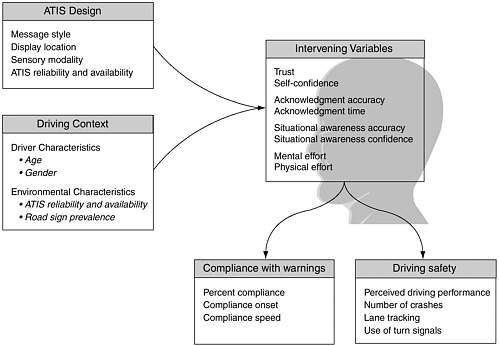
FIGURE 4-5 Factors moderating the effect of ATIS design characteristics on driving safety and warning compliance. SOURCE: Federal Highway Administration.
Recommendation: Support human factors research to obtain desired responses to road weather information.
The road weather research program should support research into the human and cultural factors involved in driver decision making under a variety of weather conditions and in driver response to new technologies for the delivery of road weather information. Important aspects of this research include the information, content, and format for optimum response, and safe methods for communicating with vehicle operators, especially during hazardous weather conditions. The FHWA’s program for an Advanced Traveler Information System has acknowledged that technology exists to display information to the driving public, but there is little knowledge to guide the proper selection of methods and displays. This research should build on the work done by the Advanced Traveler Information System, Commercial Vehicle Operations, and Advanced Traffic Management Systems and be compliant with the National ITS Architecture Maintenance and Construction Operations user service bundle. Additional research is needed on effective communication of road weather information to traffic managers, maintenance personnel, and emergency managers, as they have specialized needs that are significantly different from those of the general public.
Vehicle Technology
Major advances in vehicle technologies for providing drivers with improved weather information have come about through research and development of “telematics,” or in-vehicle information and communication technologies and services. The private sector has led research and development efforts in the field of telematics to date. A variety of telematics features are available or under development, including
-
safety, security, and location services;
-
remote vehicle functions (e.g., door unlock, sound horn);
-
vehicle maintenance diagnostics and prognostics;
-
personal information services (e.g., stocks, news, weather, traffic, text-to-speech e-mail); and
-
hands-free phone with voice-activated calling.
Several of these technologies require a capability for a vehicle to communicate directly to a central server where data processing takes place and
appropriate responses are set into motion. A centralized repository and server is also needed for providing information to vehicles and drivers. In some cases this central server may be operated by the automobile manufacturers, while in others a third-party vendor may be involved in retrieving and processing data from automobiles and responding to driver requests for information.
Telematics systems require technology in the vehicle, a wireless carrier of voice and data (e.g., cellular), and a service delivery network. Typical technologies used on the vehicle include the global positioning system, communication capabilities (i.e., audio interface, microphone, antenna), and hardware and software to implement instructions to the vehicle. Either embedded telecommunication units or portable telephones, or both, are used to communicate between the vehicle and the service delivery network. The embedded units have the advantage of always being “on” but are less portable than portable phones. Using both an embedded unit and a portable phone provides the highest level of functionality but is more expensive. The service delivery network includes databases that store information of potential interest to motorists and those that store information about performance and possible maintenance needs downloaded from the vehicle. The service delivery network may also include a workforce to respond individually to driver requests.
Ford Motor Company estimates that there will be 12 million telematics service users by 2008 (Miller, 2003). Even so, many original equipment manufacturers are stepping back from major telematics commitments as they reevaluate the business model to determine which services customers want and how much they will pay for them. In the United States, emergency roadside assistance has been the most widely adopted. The OnStar system is the most extensively used telematic service in the United States, with responses monthly to 500 air-bag deployments, 15,000 remote-door unlocks, 375 stolen-vehicle tracking calls, 200,000 route-support calls, and 14,250 road assistance calls (http://media.gm.com/division/2003_prodinfo/03_corporate/telematics.html). European telematic systems that include navigational services in addition to roadside assistance have gained popularity, while the Japanese have more quickly adopted both services and Internet-based infotainment.
The development of “smart vehicles” is a critical component of intelligent transportation systems. Intelligent vehicle systems can complement the information gathered by highly instrumented roadways. Some examples of technologies under development include precrash sensing using radar and optical sensors along with wireless communication between vehicles; sens-
ing of vehicle occupants so as to optimize vehicle performance; instruments to assess the surrounding environment, including surface friction, temperature, and precipitation; reconfigurable and “head-up” displays; and automatically adjusting such features as windshield wiper function and the temperature of the car interior. Of particular relevance to weather is smart navigation, in which sensors on the vehicle report road conditions (e.g., iciness, traffic, incidents, construction) back to a traffic operations center, and the server sends to all drivers on that road alternate routes as necessary. Further research is needed for the roadway community to take full advantage of these new vehicle technologies.
Part of the vision for the new generation of vehicles is that they should communicate with each other about their speed, location, and heading information. This capability, combined with omnidirectional sensors that would alert the driver to potential collisions, could dramatically decrease the likelihood of accidents. Sensors in the vehicle that identify poor road conditions (e.g., iciness) could communicate the location and problem to vehicles traveling behind it. This would allow the driver or the vehicle to adjust to the conditions.
Most original equipment manufacturers are looking to provide new telematics technologies with an open architecture. They are not planning to be service providers and will not develop content or the service delivery network. Rather, the open architecture will allow other businesses to enter that market. Several manufacturers have agreed to standardize the interfaces between vehicles and communication networks. They have founded the Automotive Multimedia Interface Collaboration to facilitate the development and standardization of multimedia interfaces to vehicle communication networks. For these standards to be of optimum utility they should have an open architecture and be integrated into ongoing intelligent transportation systems (ITS) development.
MODELING CAPABILITIES AND FORECAST TOOLS
Improving modeling capabilities and forecasting tools should be a key objective of a new road weather research program. These efforts should build on existing capabilities in both the meteorology and transportation communities and exploit potential new capabilities (Table 4-2). As discussed in more detail in Chapter 3, numerical weather prediction has increased substantially in sophistication and performance since its inception in the 1950s. However, these efforts have largely centered on forecasting synoptic and mesoscale weather conditions on scales larger than the spatial
TABLE 4-2 Existing and potential models that should be applied to road weather research and operations
|
Model Function |
Model |
Description |
|
Numerical weather prediction |
Eta |
Highest-resolution National Centers for Environmental Prediction model with a 12-km grid spacing. All of North America is included in domain with forecasts to 84 hours. Model output includes conventional fields such as pressure, precipitation, dewpoint temperature, temperature, heights, and winds, plus many other derived quantities. |
|
|
Regional mesoscale models, including, for example, Regional Atmospheric Modeling System (RAMS) and Fifth-Generation National Center for Atmospheric Research (NCAR)/Penn State Mesoscale Model (MM5). |
Fine horizontal scale (grid spacing of a few km) with grids usually multiple nested. Lateral boundary conditions from larger-scale operational models. |
|
|
Weather Research and Forecasting (WRF) |
High-resolution research and forecast National Weather Service model with horizontal grid of 1 to 10 km. A new community model being jointly developed. Plans include assimilation of very-high-resolution data such as radar. |
|
Modeling the roadway environment |
One-dimensional energy-balance models |
Models vertical exchanges of heat and moisture within a vertical column by including weather information and road surface properties |
|
|
Multi-dimensional energy balance models |
Models full three-dimensional energy balance by accounting for the complex terrain of an environment (e.g., vegetation, topography) |
|
Traffic simulation and management |
Dynamic Network Assignment-Simulation Model for Advanced Road Telematics (DYNASMART-X) |
Mesoscale (areawide) planning model that provides estimates of traffic conditions, flow patterns, and rerouting based on simulated driver choices |
|
Operated by |
Road Weather Application |
Limitations |
|
• National Weather Service • Workstation version available to private sector and academia |
• General weather outlook through day three • Subsynoptic-scale weather prediction • Highway maintenance decision making • Can provide initial conditions and boundary conditions for road-surface models |
• Insufficient resolution to capture finer mesoscale phenomena (e.g., thunderstorms, small terraininfluenced circulations) • Much too coarse to provide direct forecast for roadway environment • Inadequacy of data to define initial atmospheric conditions and the surface boundary conditions (e.g., landscape, soil, and vegetative conditions) • Inherent limits of predictability on the desired time and space scales |
|
• Academia • National Weather Service local partners • Private sector |
• Mesoscale weather predictions specific to a certain region • Highway maintenance decision making • Can provide initial conditions and boundary conditions for road-surface models |
• Incomplete or lack of coverage for parts of United States • Intermittent operations • Vulnerable to outages • Unsteady funding |
|
• Government labs • Academia • U.S. Air Force |
Mesoscale weather prediction |
• Relatively new model still in development • Not currently available for routine operations • Development research is ongoing |
|
• Academia • Private sector • Government labs |
Predicts the temperature and wetness of a roadway surface for tactical (< 6 hours) and strategic (> 6 hours) purposes |
• Only completely accurate when atmosphere and road surface conditions are horizontally homogenous |
|
• Academia • Private sector • Government labs |
Predicts the temperature and wetness of road surfaces and their surrounding environment |
• Computationally intensive • Expensive • Requires substantial input data |
|
• University of Maryland • University of Texas |
Traffic management in adverse weather |
• Difficult to model human behavior • Relies on good time-varying origin-destination data |
|
Model Function |
Model |
Description |
|
Traffic simulation and management (continued) |
Dynamic Network Assignment for the Management of Information to Travelers (DynaMIT) |
Mesoscale (areawide) planning model that integrates historical databases with real-time data to estimate traffic conditions, predict future conditions, and provide information to drivers |
|
|
Hurricane evacuation models |
Models that simulate roadway operations (e.g., congestion, clearance times) using weather, flood, traffic, and geographic data to determine best routing and re-routing decisions |
|
Decision Support Systems |
Maintenance Decision Support System |
Assembles weather conditions of an area, predicts the potential for deteriorating conditions, plans treatment scenarios, and provides decision makers with treatment recommendations |
|
|
High Performance Paving (HIPERPAV) |
Prediction tool that uses temperature, wind, humidity, and cloud cover information to predict optimum paving windows for roadway construction |
|
Coupled atmospheric-traffic simulation models |
|
End-to-end models that integrate weather and traffic data to guide decision support |
scale of a roadway. Models of traffic and road surface conditions are available, though they are not used as routinely as are weather models.
The road weather system of the future will depend on greatly improved forecast capabilities, but attaining the desired skill in forecasting weather and road conditions on the scale of the roadway will require significant advances in modeling and empirical techniques. For example, current numerical weather prediction capabilities, described in more detail in Chapter 3, are limited in several ways, including
-
inadequacy of data to define initial atmospheric and surface boundary conditions (e.g., landscape, soil, and vegetative conditions);
|
Operated by |
Road Weather Application |
Limitations |
|
Massachusetts Institute of Technology |
• Traffic management in adverse weather |
• Difficult to model human behavior • Relies on good time-varying origin-destination data |
|
• Academia • Private sector • Government labs |
• Traffic management during evacuations • Can be used in real-time by emergency management officials • Locate emergency shelters for drivers |
Real-time models require substantial data input |
|
Federal Highway Administration |
Provides maps of road weather conditions along road corridors for 1 to 48 hours for maintenance crews |
Relies on the accuracy of weather forecasts |
|
The Transtec Group |
Optimal roadway construction based on weather conditions |
Relies on accuracy of weather input data |
|
Not yet developed |
• Improved traffic management in adverse weather • Simple, more uniform information for users and maintainers |
• Computationally intensive • Requires substantial input data |
-
suboptimal resolution and accuracy of numerical weather prediction or empirical models; and
-
inherent limits of predictability on the desired time and space scales.
Advances in future roadway weather forecasts will depend on how well the high-resolution land surface properties (e.g., soil moisture, topography, vegetation type, soil type), hydrological aspects (e.g., soil infiltration, runoff), cloud microphysics, and boundary layer physics are parameterized and incorporated into numerical weather prediction models. As shown in Table 4-2, other modeling approaches applied to the road weather problem are similarly limited, for example, by computational capabilities or difficulty in
representing human choices or for institutional reasons. How to support the development of these models and other forecasting tools strategically and cost-effectively will be a challenge facing the proposed road weather research program.
Deficiencies in the parameterizations within the numerical weather prediction model are frequently responsible for significant biases in predicted parameters especially within the boundary layer, which is the most critical to road weather forecasts. As such, post-processing of model output is often necessary. Historically, this has been done subjectively by the human forecaster with the aid of statistical tools and experience. In addition, the forecaster has routinely added value by “smoothing” run-to-run inconsistencies and offering expert interpretation of the objective predictions.
The NWS has just started to present its forecasts digitally through the Interactive Forecast Preparation System and the National Digital Forecast Database. This system is designed to take advantage of the resolution of the prediction models, yet allow the forecasters to continue to play a significant role in the process. The forecasts are delivered on a 5-km grid through seven days and deliver many forecast parameters. The National Digital Forecast Database system should provide basic high-resolution forecasts directly to a broad spectrum of users. In addition, it will provide the private sector an excellent opportunity to add value through customization and tailoring for their customers, especially in the area of transportation and road weather applications.
New road weather modeling and forecast tools should be developed to provide relevant, useful information to those who build, maintain, and use the nation’s roadways. The road weather research program must support a range of model development and forecasting activities. For example, improvements are needed for models of weather in the microscale roadway environment. This advancement will require modifications to current numerical weather prediction techniques, which typically apply to much coarser spatial domains. Likewise, roadway transportation models need significant improvements to dynamically account for weather. Currently, most models of traffic flow ignore the impacts of weather. A long-term objective of the road weather research program should be to develop end-to-end models that seamlessly integrate real-time observations of weather and traffic, now-cast and forecast models for weather and traffic, and decision support systems for applying the model output to user needs. These end-to-end models will build upon the advances in the meteorological and
transportation modeling efforts. The following sections describe this range of modeling efforts in more detail.
Modeling the Microscale Roadway Environment
Energy-balance models provide information useful to road managers on both tactical (< 6 hours) and strategic planning (> 6 hours) time scales (Crevier and Delage, 2001). These models can be strengthened by constraining them with assimilated weather and road condition data. Even if road weather models have imperfect parameterizations, accurate and well-placed road weather information systems will lead to improved forecasts. In the short term, maintaining an accurate, up-to-date database describing road and bridge properties (e.g., composition, structure, depth, roadbed characteristics) for the network of interest would enable more accurate estimates of the thermal characteristics and thus should result in improved forecast accuracy. Such databases could be evaluated using qualitative methods such as comparing recorded road properties to model predictions and the results of road thermal mapping. The relevance of chemical reactions involved in road treatment needs to be examined and if necessary included in the energy-balance models. On a time scale of 5 to 10 years, continued expansion of RWIS installations to areas identified as critical either because of known hazards or poor model performance would lead to forecast improvements.
Alternative semi-empirical approaches to determining the energy balance at the road surface, such as expert systems, also show promise, particularly in the context of improved RWIS, pavement sensors, and weather-forecast inputs. These will be particularly useful for vulnerable areas, such as bridges or ravines, where local conditions frequently create hazardous conditions but the local physics compromise the validity of the one-dimensional energy-balance approach.
Modeling of conditions that produce dangerous winds or drifting snow is an important consideration for many rural areas. Wind-tunnel (physical) modeling, large-eddy simulations, or empirical approaches could be used for this purpose, as well as for designing mitigation strategies (e.g., built or living structures for protection from drifting snow).
In the intermediate to longer term (10 to 15 years), improvement in road surface forecasts will require more accurate mesoscale weather forecasts and better representations of the local heat, moisture, and momentum exchanges. Such improvements will enhance abilities to simulate localized
weather phenomena, such as fog development and nocturnal drainage flows. Improved modeling of both mesoscale fields and local energy balances under conditions of strong vertical gradients in the atmospheric boundary layer or significant temperature differences between the atmosphere and the surface is especially needed.
Many factors that affect the roadway environment (See Table 3-1) are represented in the newer roadway models through parameterizations. Following the development of such parameterization schemes, they should be tested and refined using further observations. Such testing should concentrate on individual factors (e.g., traffic intercepting infrared and visible radiation, how much heat is generated by vehicles), common but simpler combinations of factors (e.g., traffic on a dry road, traffic on a wet road with steady precipitation), or the final model product (e.g., road temperature). Measurement of the heat loss from the road to the atmosphere will be a challenge in the heterogeneous roadway environment, but Wojcik and Fitzjarrald (2001) have been able at least to make estimates within useable limits.
Recommendation: Improve empirical and numerical modeling techniques to account for both the roadway atmosphere interface and the surrounding environment.
The roadway environment consists of two components: (1) the road surface and (2) the weather and visibility conditions directly above the road. For the former the committee recommends that research be pursued to improve one-dimensional modeling techniques for the roadway-atmosphere interface, the region that extends a few meters above and below the road surface. Advances in this area would enable better forecasts of road surface temperature, leading to better forecasts of frost and black ice. For the latter, empirical and multidimensional modeling approaches should be developed to account for local terrain, land cover, surface composition, and other geographic features that affect the exposure of the roadway to infrared and solar radiation (direct and indirect), wind, and precipitation. Such models need to provide improved forecasts of road surface temperature and condition (e.g., dry, wet, frozen surfaces) as well as fog, wind, and other localized atmospheric phenomena.
The information required for decision makers, like the available options, varies according to the time frame. Builders planning new roads in snow-prone areas will want to know where the combination of terrain and
wind indicate a need for snow mitigation devices (snow fences). Bridge construction crews that want satisfactory conditions for the curing of concrete may want a projection of temperature over the first few days after the concrete is to be poured (Wojcik and Fitzjarrald, 2001). Trucking companies can use 1- to 3-day weather forecasts to plan cross-country routes. Road managers deciding whether to put their snowplow crews on call would use the 18- to 24-hour projection of the timing and severity of a predicted snowstorm. Over shorter times the road manager would be interested in how the weather, snow mitigation strategies, traffic, and roadway properties affect roadway performance and safety.
In the tactical 0- to 6-hour time frame a mix of observations and road weather models is needed to provide the most useful results. In the absence of such models empirical relationships of road temperature or slickness at a given location to weather conditions can also be useful, especially for the shorter time frame changes. Indeed, simple measurements of road surface temperature, images of fog or snow on roadway Web cams, or reports of accidents can override model predictions on the less-than-2-hour time frame in decisions to keep a road open or closed. As lead times approach 6 hours, current data become less useful, and some models may not have “spun up.” For such situations, ways to optimize the information available at these intermediate time scales must be developed. This likely will be the domain of the human forecaster, especially in cases of severe and hazardous weather, until the objective techniques become skillful within this “gap” period between observations and numerical weather predication forecasts.
Recommendation: Improve accuracy and resolution of road weather forecast products supporting both tactical and strategic decision making.
The road weather research program should support development of tailored road weather information products to support real-time operations and both near-term tactical (0 to 6 hours) and longer-term strategic (> 6 hours) decisions by road users and managers. More accurate weather information products should be developed on fine spatial and temporal scales appropriate to the roadway environment, in part by taking advantage of advances in nested and ensemble models. Producing road weather forecasts for the 2- to 6-hour timeframe presents the greatest research challenge because current data become less useful and some models may not have reached the point where they can provide useful output. As a result, this short-term forecast problem likely will remain a focus of the human forecaster and newly emerging statis-
tical tools for the near future. The newly developed National Digital Forecast Database from the National Weather Service provides forecasts across the United States on grid spacing no greater than 5 km and may provide a logical starting point for either user-developed applications or further enhancement by the private sector.
It is possible that current approaches to attaining finer spatial resolution information from numerical weather prediction models will not yield forecasts of sufficient accuracy for the roadway environment. These approaches include developing finer resolution versions of existing models, downscaling output from mesoscale models, and nesting methodologies. It may be necessary to pursue alternative methods for producing road weather forecasts. These might include statistical applications such as neural nets, empirical models, or probabilistic estimates derived from ensemble forecast systems. The leadership of the road weather research program must support research to determine the best strategy for maximizing predictive skill at minimum cost, this leadership will also have to determine whether a numerical weather prediction model development approach that focuses on downscaling of the conventional mesoscale modeling technology is the correct strategy.
Roadway Transportation Models That Account for Weather
The transportation community has long recognized the relationship between weather conditions and the operation of the transportation system; however, for many reasons the impacts of weather have generally not been incorporated into the tools used by transportation professionals to evaluate alternative transportation strategies.
Transportation planners and engineers use a variety of tools to plan for and operate the transportation system. Development of numerical traffic models began in the 1950s with simple car-following algorithms, followed by regional travel demand forecast models in the 1970s (macroscale), and evolved into complex models that simulate traffic flow and individual vehicle movement for major traffic corridors in a metropolitan area (mesoscale), along a given traffic route, such as a stretch of interstate highway (microscale), or flow through a given complex highway interchange (picoscale). Such models are used to identify the most effective physical improvements to make and to determine the optimum strategies for operating the system.
To date, these models have predominantly been used to make planning decisions. In planning the system, alternatives are studied for how best to
accommodate demand on a portion of the transportation system. Such options as adding lanes, adding turn lanes, and designating lanes for special purposes (e.g., commuting) are analyzed. More recently traffic models have been used in a few places to operate the system, providing predictive traffic information for real-time traffic management. Such alternatives as differences in signal timing or ramp metering can be evaluated and immediately implemented. Strategies for best handling of incidents, such as accidents or flooding, can be analyzed with these models.
While these models consider many variables in their analysis, and while weather is known to be a significant variable, virtually all the tools assume the system is operating under acceptable, dry weather conditions. Considerable research has been conducted to identify the impact of factors such as lane width and shoulder width, but little research has been done to establish the impact of weather conditions on the operation of the transportation system. Significant research in this area is needed to conduct sensitivity studies over a plausible range of weather conditions. For example, efforts are needed to determine the relationship between rainfall intensity or duration and key traffic variables, such as roadway capacity, maximum speed, acceleration or deceleration rates, car-following parameters, lane-changing parameters, headways and startup times, and the range in driver speeds, all of which are important in evaluating transportation options.
Recommendation: Integrate available weather information into traffic planning and management models.
The committee recommends research to improve the way weather effects are included in traffic and emergency management models, which currently are used for offline design and planning of transportation systems. Better accounting for weather in these models will allow researchers to assess the benefits of improved weather monitoring and forecasts on transportation operations and enable practitioners to more efficiently manage the nation’s roads.
The committee believes that over the next 15 years there is significant opportunity for the roadway community to couple atmospheric and traffic simulation models for real-time management of the transportation system. Such an initiative would not have been possible 10 years ago because numerical weather prediction and traffic simulation models were not sufficiently mature to be linked efficiently. That is not the case today. Indeed, traffic simulation models that can ingest real-time data—such as incident reports, traffic flow data, and work zone status reports—and even predict
near-future traffic conditions are being developed. Two such models are the Dynamic Network Assignment-Simulation Model for Advanced Road Telematics model (DYNASMART-X) and the Dynamic Network Assignment for the Management of Information to Travelers model (DynaMIT). These models try to predict the behavior of vehicles by simulating thousands of driver choices every few seconds and predicting when those choices will converge to create congestion (Vatalaro, 2001). These models show great promise for supporting traffic management in developing real-time routing and rerouting scenarios for more efficient system management, but they do not ingest weather data.
Coupling atmospheric and traffic simulation models provides opportunities to address significant problems related to roadway safety, capacity, and efficiency. Some of the areas of opportunity are as folllows.
-
Congestion Mitigation: Coupled models for urban roads to detect and predict weather elements that contribute to congestion assimilate the dynamic data into the traffic simulation model and modify the traffic flow accordingly. The resultant output could trigger mitigation strategies, such as access control, ramp metering, speed management, weather-related incident detection, weather-related traffic signaling, and public advisories.
-
Emergency Evacuation Strategy Development: Coupled models covering regional areas that contain urban areas, nuclear power plants or other facilities that have potentially hazardous releases, and hurricane-prone stretches of the U.S. coast could predict the movement and concentration of hazardous materials by local winds that feed into traffic simulation models that identify safe and unsafe evacuation corridors. These identified areas could trigger mitigation strategies, such as contraflow, access control, incident response and public advisories to facilitate the movement of people away from the danger in the most efficient manner. Use of the system for hurricane evacuation would identify similar hazardous areas to be avoided and initiate similar mitigation strategies, particularly contraflow and access control.
Although both model development paths are fairly mature, there is still much research that is required to tap the opportunities outlined above. Work needs to be done to determine how to best use weather information in traffic simulation models to allow them to further optimize traffic flow for a range of weather conditions in a robust and stable manner.
A phased approach to development is likely the best path, beginning with more straightforward problems, including simple prototypes, and then
migrating to more complex problems; for example, determining the effect of light, moderate, and heavy precipitation on traffic flow along certain corridors could be a beginning point. More complex problems, such as drifting snow on the roadway and crosswind effects on high-profile vehicles, would be addressed at a later stage. Given the current strong focus on homeland security, it might be appropriate to begin the research with coupled systems that take a simple, first-guess estimate of a toxic plume’s location and movement and determine how this information can be effectively used in a traffic simulation model. Predictions of plumes that are highly complex in their movement to local winds and atmospheric stabilities could be addressed later as confidence in the coupled system increases.
Recommendation: Use real-time weather information in the operation of the transportation system.
The road weather research program should support development of operational modeling systems for roadway management that include real-time weather information. The use of real-time weather information to support the operation of the transportation system is in its infancy but should be encouraged; for example, the road maintenance community has made advances in incorporating real-time weather information in decision support systems for winter operations. Real-time road weather information would also be useful for warning drivers of dangerous weather conditions and for optimizing commercial vehicle operations.
End-to-End Models
Decision support systems are the largest category of weather-related needs for the transportation system manager. For decades weather information has been assimilated by these managers using a method that some refer to as “swivel chair integration.” That is, the decision maker considers each separate category of weather-related information independently and then tries to integrate the accumulated information manually to make a critical decision. Many managers have learned to do this quite well, but their decision making process will almost always be different than their colleagues; this means that inherent inconsistencies exist across the team of decision makers in any given facility.
If one adds to this a process that is very inefficient by its nature, there is no wonder that most facilities have come up with a consensus process that
is conservative for the group. In other words each decision associated with a weather scenario is not optimized in a benefit-cost sense. Winter maintenance rules of practice, for example, tend to be too conservative, usually resulting in a higher than required margin of safety and the application of more chemicals to the roadway. This practice results in higher costs and negative effects on the environment.
The roadway management decision process is further complicated by the fact that weather is only one of several decision criteria that need to be assessed. A reliable, consistent decision maker must integrate all these factors to be successful. Modern decision support systems can integrate all this information consistently and reliably, but use of such systems is rare in today’s roadway management systems.
The need for decision support applications is widespread, even in the traffic management community. Some of the needs are as follows.
-
Integration of weather-based decision support systems with traffic simulation numerical models is required to diagnose and predict traffic flow in urban areas for short periods into the future. The primary weather-related information needed is pavement condition (e.g., wet, dry, icy, snow-covered), precipitation type and rate, wind speed and direction, road friction measurements, and obstructions to the driver’s vision (e.g., sun glare, fog, smoke, dust, or blowing snow). This decision support information is needed to advise motorists of predicted and prevailing conditions, to alter the state of roadway devices to control traffic flow and regulate roadway capacity, and to supply resources to roads to mitigate weather impacts.
-
Decision support technology is needed to trigger warnings of dangerous conditions along the roadway resulting from weather events. Some examples are reduced driver visibility ahead, cross-winds exceeding 50 mph ahead that can tip over high-profile vehicles, severe thunderstorms (hail, heavy rain, high winds), tornadoes, icy road conditions ahead, flooding on the roadway, hurricane conditions, movement of wildfires near the roadway, and the movement of chemical, biological, or nuclear hazardous material along the roadway (OFCM, 2002a).
-
Decision support technology is needed to optimize commercial vehicle operations. This would enable truck routing to exploit weather information for just-in-time delivery and to minimize fuel consumption and allow the safest routing for hazardous cargo shipments based on road condition and winds relative to vulnerable assets and temperature.
An end-to-end road-modeling system has enormous potential to enable road managers and emergency responders to develop better responses to everything from developing strategies for safer driving in fog and responding to extreme conditions, such as evacuating the coastline in anticipation of hurricane landfall. The required modeling system would have to incorporate changing weather conditions, preferably with high horizontal and temporal resolution to account for local variability; a model of road conditions, especially road temperature and slipperiness; a traffic simulation model that includes the reaction of drivers to such conditions as precipitation, wind, and traffic; and traffic mitigation procedures, such as timing traffic lights, switching direction of highway lanes, and dynamic message signs.
Recommendation: Develop end-to-end models that assess and predict weather impacts on roadway conditions and operations.
The road weather research program should support a long-term, interdisciplinary effort to develop end-to-end road-modeling systems. The required modeling system would have to incorporate (1) current weather and pavement conditions; (2) “future” or forecast weather conditions; (3) a model of road conditions, especially road temperature and traction; and (4) a traffic simulation model that includes the reaction of drivers to such conditions as precipitation, high winds, low visibility, slick pavement, and congestion mitigation strategies (e.g., timing traffic lights, commuter highways, weather-controlled dynamic speed limit signs). Used in an offline planning mode, such a system has enormous potential to enable road managers and emergency responders to develop better proactive responses to extreme weather conditions. As understanding, modeling sophistication, and computer capabilities allow, such models ultimately could be run in real time to assist in the routine management of the transportation system, thereby enhancing safety, capacity, and traffic flow.
COMMUNICATION SUPPORT FOR ROAD WEATHER INFORMATION USERS
The road weather research program should support the development of multiple mechanisms for communicating road weather information to a range of users in a manner that supports more informed decision making. Communication is important for making the research results useful to drivers and those who build, maintain, and operate the roadways. Development
of improved mechanisms for communicating weather information to roadway users is already under way: traffic and weather information is often relayed together in radio and television broadcasts; many states have implemented 511, a single nationwide phone number for traffic and road condition information; and roadway managers are making greater use of dynamic message signs. The Maintenance Decision Support System pilot project has developed a prototype tool with which winter maintenance operators can obtain highly targeted road weather observations and forecasts, as well as assistance in choosing the best treatment options.
The committee sees a road weather research program in which two-way communication allows researchers to learn from stakeholders about their needs and thus build better decision support tools for them. In addition to setting up effective mechanisms for communication, the road weather research program should support research on ways to improve communication. Two areas on which this research should focus are improving the ability to convey levels of confidence associated with road weather information and taking advantage of newly available communication tools.
Conveying the Confidence Level
Testimony to the committee by both users and providers of advanced weather technology indicated a strong need for conveying not only timely, accurate, and reliable diagnostic and prognostic information to decision makers, but also the degree of uncertainty in this information. Users have historically shied away from probability metrics associated with forecasts, in some cases because the need is misunderstood and the metrics are considered merely a way for prognosticators to dodge their real need: a perfect weather forecast out to a week or so. Even though the user might have understood the need for the uncertainty metric, intelligent use of the information was another problem; very few users had systems that could ingest this information and analyze its value to the decision maker. Now, advanced weather decision support systems that assimilate many diverse sources of weather and operational databases have uncertainty metrics as a by-product, and in many ways depend on the metrics for their value to the user, for example, cost analyses can be done effectively by ingesting probabilistic weather data along with information about available resources and operational status.
In addition to developing robust methods for estimating the degree of confidence in road weather information, it is important to devise effective
methods of conveying uncertainty information to users. Communicating uncertainty was the subject of a recent National Research Council workshop during which lessons learned from several weather and climate case studies were discussed (NRC, 2003a). The workshop participants found that communicating uncertainty is a critical part of decision making for users of weather information, and it is important to communicate both why information is uncertain and why that uncertainty matters. The workshop report stresses that multiple measures of uncertainty, both quantitative and qualitative, should be communicated, along with a context to tie the information to past experiences and to make the uncertainty information more tangible.
Despite advances, much research is needed on conveying uncertainty in road weather information products and improving easily understood metrics to facilitate user decision making. New ways are needed to include a more complete representation of the sources of uncertainty and to communicate the context of the information. The format of information (e.g., text, graphics, numbers) may serve to modify its interpretation even when the underlying information is unchanged. Simply repeating the same information tends to convey that it is more credible. Recent memory of similar events may color interpretations, whereas prior education about how to interpret information can improve decision making. Even though the NWS has developed products to provide uncertainty information to address some user needs (e.g., the probability of measurable precipitation or the seasonal and monthly outlooks), much work needs to be done with users to address the full expanse of their needs and determine the best ways to convey uncertainty to them. This is particularly true with the newly implemented National Digital Forecast Database, which presents very high resolution (5 km grid spacing) forecasts through seven days without the benefit of confidence or uncertainty information.
Recommendation: Develop methods for estimating and conveying the degree of confidence in road weather information.
The road weather research program should support the development of means for estimating the inherent uncertainty in road weather information. Advanced weather decision support systems that assimilate many diverse sources of information need to estimate uncertainty and provide easily understood metrics to aid users in making optimal decisions. New methods are needed to enable more effective communication of uncertainty to a wide variety of users.
New Communication Tools
Systematic collection and dissemination of road weather data are critical to the success of the road weather research program and require robust communication technology. For example, collection of real-time data invariably involves some form of data logger at the measurement site, telecommunication means (e.g., telephone line, fiber line, microwave relay), and a reception facility that moves the inflowing data stream to archival servers. These communication means are often already in place in roadway right-of-ways, either for commercial communications providers, law enforcement, or state departments of highways themselves.
A number of new wireless technologies may enable communication with motorists when and where they need it. The technologies that hold the most promise are satellite radio, cellular, and wireless local area networks. When considering how each of these technologies may be used for communicating road weather information with drivers, it is necessary to consider how much information can be transmitted and whether it is possible for two-way communication, how far the signal can be transmitted, and how ubiquitous the technology is. Also weighing into the decision are human factors, such as familiarity, ease of use, and cost. Each of these technologies is capable of transmitting different bandwidths, which affects the type of information that can be sent.
Satellite-based Digital Audio Radio Service, which provides radio coverage across the continental United States, has been implemented recently. With a satellite-capable radio receiver and a subscription to a satellite radio service, consumers at home or in their automobiles are able to receive detailed graphic weather and traffic reports that are customized for their location. Although this technology currently is available only to emergency response vehicles, it may become commercially available soon. Several automobile manufacturers are beginning to offer satellite radio as an available factory option. Satellite radio is an improvement over regular radio because it has better coverage and bandwidth, while allowing geolocated transmissions. Nevertheless, regular radio remains critical for transmitting weather information to drivers because the costs to consumers are minimal.
Cellular communication provides many features that match the needs for communicating weather information to drivers. In most parts of the country, cellular signals have a range of miles (see Figure 4-6) and a relatively ubiquitous infrastructure in place, with many of the cellular towers installed along interstate highways. The technology is flexible and the focus
FIGURE 4-6 Schematic illustrating the spatial range over which different communication technologies extend. SOURCE: Ian Ferrell, Microsoft Corporation.
of much innovation, making it likely that applications for the road weather problem might be developed. In particular, it is possible to send individualized broadcasts, for example with information about weather on an adjacent stretch of road, from each cell tower. Again, human factors, such as familiarity, ease of use, and cost will play a role in the feasibility and success of such applications.
Wireless local area networks have a much larger bandwidth than cellular and recently were tested successfully at highway speeds of over 200 mph (http://wireless.itworld.com/4260/031020necwifi/page_1.html). Implementation of this technology may occur soon, but until then wireless local area networks are well suited for in-car communications with other devices and for communication between the vehicle and physical points, such as a home, gas station, or rest stop. Very detailed information about local weather and road conditions, including animated forecasts or other large-bandwidth data, could be transmitted to a vehicle located at a rest stop. As with
cellular, wireless local area networks support two-way communication and are the focus of much technological innovation; however, little infrastructure has been developed to support wireless local area networks communication with vehicles, so coverage is very poor at this time.
Recommendation: Develop new means to effectively communicate road weather information to a wide range of users.
The road weather community should take advantage of new and upcoming advances in technology that will enhance communication to users. Along with expanded observational capabilities, advanced communications technology must be deployed to enable instruments to transmit data back to central processing centers and to relay processed weather information back to drivers and other users. Advances in wireless communication hold much promise for providing location-specific weather information to mobile users, but the challenge of determining how best to use these communication technologies remains.
INTEGRATING WITH THE EMERGING INFOSTRUCTURE
A final but nonetheless critical emphasis of the road weather research program should be to develop a telecommunication infrastructure that takes advantage of new technologies to effectively convey road weather information to end users. Previous recommendations in this report have included the establishment of a nationwide real-time road weather observation system. Such a national integrated network of fixed and mobile stations would generate an enormous amount of valuable information about the weather affecting roads and travelers and the resultant condition of the road network. All of these data would need to be carefully and uniformly quality controlled to common national standards to ensure consistent and appropriate use by multiple agencies (also a prior recommendation). The meteorological community, both public and private, would make use of this rich dataset to refine numerical weather predictions of the atmosphere and determine future impacts on the roadway environment (Smith, 2001). Weather impacts permeate the entire transportation system and must be factored into all manner of road transportation operations and systems. Clearly, there is a substantial telecommunications requirement to first collect road weather and condition data from multiple fixed and mobile platforms and then move road information and finished products to transportation managers and road users.
A national telecommunications and information technology infrastructure or “infostructure” is required to move all this information. This infostructure must be adapted to respond to the specific needs of the road transportation sector. The National ITS Architecture, discussed in Chapter 3, provides the overall blueprint for this infostructure. It starts out by identifying the basic elements of road transportation and then groups them into four categories or systems: travelers, vehicles, field, and centers. Within each of these systems, specific elements or subsystems with unique needs are defined; for example, the vehicles group includes maintenance and construction, transit, commercial, emergency, and regular passenger vehicles. Sub-systems are defined, based on extensive user interviews, for the other main systems: centers, field, and travelers.
The National ITS Architecture then goes on to define basic telecommunications links between all of these systems. These are grouped into four classes: (1) from the centers to the field, regular wireline (fixed-point to fixed-point) communications suffice and are specified; (2) between the field and vehicles, Dedicated Short Range Communications provides the solution from fixed points to moving vehicles; (3) vehicle-to-vehicle communications; and (4) wide-area wireless communications.
The very serious safety and efficiency impacts that weather exerts on road transportation are recognized and have been included throughout the Architecture. Each of the fundamental activities leading to better management is covered: data acquisition, processing, dissemination, and integration into end-to-end applications. In responding to the needs of road transportation the meteorological community must take full advantage of the infostructure as specified by the Architecture. Road weather and condition data are collected from multiple fixed sites and from vehicle fleets hosting road and weather sensors. Links are specified to move the data to primary operators of the sensing equipment, the road maintenance and construction community. The architecture then provides for the data to be moved to other agencies for processing into useful information. This includes quality assuring the data, analyzing them, generating road weather forecasts from them, and finally packaging and returning all this information to all manner of road transportation users. The applications range from integrating time and location information into future in-vehicle audio and video display systems to ensure rapid and easy assimilation by motorists while driving to integrating high-resolution road weather modeling outputs directly into end-to-end solutions for road maintenance and traffic and emergency management.
The transportation community has taken the first and most important step of recognizing the impacts of weather and the need to factor weather information into their operations. The National ITS Architecture incorporates design elements for road weather telecommunications. The weather community needs to work through the Architecture with transportation professionals to respond to road transportation’s specific needs. This process is already engaged. Weather and transportation professionals worked together on ITS America’s Weather Information Applications Task Force and the FHWA’s own Maintenance and Construction Operations (MCO) User Forums to develop the MCO User Service. Other activities are currently being pursued in the standards area, another main application area for the Architecture. Such standards as the National Transportation Communication for ITS Protocol Object Definitions for Environmental Sensor Stations have benefited from the participation of weather and transportation professionals. That standards effort is nearing maturity, but others are at an early stage and will need the participation of both communities in order to succeed. Numerous other future applications will require both weather and transportation expertise.
The transportation community is developing, with the National ITS Architecture as the fundamental design, a robust national infostructure adapted to the specific needs of road transportation. That infostructure presents an enormous opportunity for weather professionals to work with the transportation community to prepare and effectively deliver uniquely adapted road weather products. It is therefore crucial for the meteorological community to develop road weather professionals and engage the transportation community in the development of weather solutions for road transportation.
Recommendation: Develop a robust national roadway infostructure.
Major components of a roadway infostructure (a network of data collection and dissemination necessary to support real-time management and operation of the roadway transportation system) are being developed. The committee recommends that the road weather research program proactively participate in this effort to ensure that the road infostructure of the future incorporates a sophisticated network of road weather observations, including sensors embedded in the pavement, weather stations adjacent to the roadway, water level sensors near flood-prone routes, remote observations from satellite platforms, and instruments on vehicles themselves.


