
2
Development and Changes in the Columbia River Basin
The Columbia River basin consists of several different physiographic regions. There are alpine and subalpine environments in its mountainous regions (the Cascades, Rockies, and related subchains), an arid and semiarid Columbia Plateau and other interior areas, and a more humid lower Columbia River valley. This breadth of physical regions is expressed in the basin’s diversity of biomes, which include deserts, forests, shrubland, and riparian ecosystems. Much of the basin lies within the rain shadow of the Cascade Mountains and thus experiences an arid to semiarid climate. Precipitation is strongly seasonal; the majority of precipitation falls during the winter months, much of it as snow. The presettlement Columbia River experienced snowmelt-driven peak flows in May and June and lower flows in the fall. The Columbia’s current flow patterns have been affected by a variety of human activities. Irrigated agriculture has diverted water from the Columbia and its tributaries. Logging has altered vegetative cover and landforms, which has in turn affected surface and groundwater flows. The nation’s most extensive hydroelectric power system—the Federal Columbia River Power System (FCRPS)—was constructed on the Columbia River and its tributaries during the twentieth century. The system’s numerous dams and storage reservoirs have altered both the volume and seasonal patterns of the Columbia’s flows.1 These changes to Columbia River discharge have affected the assemblage of fishes in the basin. With respect to their impacts on salmonid populations, some adverse changes have diminished in influence over time, while others have increased. Human-
induced changes have interacted synergistically with certain natural factors, ameliorating some of these factors and exacerbating others. This chapter discusses key environmental and human features in the Columbia River basin and how human activities have impacted the basin’s environmental systems. The basin’s complex physical character and the changes induced by nineteenth- and twentieth-century agricultural, forestry, and industrial activities provide the context for considering more detailed aspects of changes to the Columbia River hydrological regime and its interactions with the life histories of Columbia River salmonids.
SETTLEMENT AND DEVELOPMENT OF THE COLUMBIA BASIN
Most inhabitants of the Pacific Northwest live in the Port-land-Seattle urban corridor west of the Cascade Mountains (Portland lies within the Columbia River basin; Seattle does not). Of the roughly 9.5 million people in the four northwestern states (Idaho, Montana, Oregon, and Washington), about 5 million live in the Columbia River basin (Volkman, 1997). Like the rapidly growing Portland-Seattle corridor, the basin’s interior has experienced population growth in many areas since the 1980s, with the largest increases in the urban areas of Bend (Oregon), Boise (Idaho), Richland/Pasco/Kennewick (the “Tri-Cities”), Spokane, Wenatchee, and Yakima (these last four urban areas are in Washington State). Beyond these cities, the rest of the basin is only sparsely populated.
Exploration and Settlement
Humans have inhabited the Pacific Northwest for at least 15,000 years (Jackson and Kimerling, 2003). Early inhabitants made a transition from hunting large game to a more sedentary lifestyle about 3,500 years ago, and salmon became an important part of their sustenance and culture. Even then, human activities
affected salmon and salmon habitat. Native Americans who lived along and near the river expended considerable efforts in taking salmon from the river, and the populations of some river-side villages swelled during the peak of the salmon runs (White, 1995). Popular sites for catching returning salmon on their upstream journeys were at the Cascades and at Celilo Falls/The Dalles. Native Americans altered the landscape in their quest for salmon, with some consequent effects on the aquatic environment. European settlers introduced a new and more intensive set of harvesting techniques, which increased the scale and pace of environmental changes and attendant pressures on salmon stocks. European settlement in the region, and associated uses in resources and changes in the landscape, varied in timing and intensity across the Columbia River basin. This progression can generally be classified as follows: initial European settlement
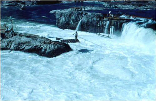
Celilo Falls prior to the construction of The Dalles Dam. Photo courtesy of Ernest Smerdon.
(1810 to 1930s); mining, livestock, and agriculture (1850s to 1910); large-scale timber harvesting (1920 to 1990s); water diversions and mainstem dams (1900 to1968; see Wissmar et al., 1994, for a review of the history of resource use in eastern Oregon and Washington).
The region’s best-known and most celebrated exploration was the Lewis and Clark expedition. After traveling up the Missouri River and crossing over the Rocky Mountains, Lewis and Clark and their Corps of Discovery floated down the Columbia River to the Pacific Ocean, spending the winter of 1805-1806 at Fort Clatsop near present-day Astoria, Oregon. Lewis and Clark noted several characteristics of the streamside vegetation in their early-nineteenth-century exploration of the region, including an increase in riparian forests as one approached the ocean:
The face of the country on both sides of the river, above and below the falls, is steep, rugged, and rocky, with a very small proportion of herbage, and no timber except a few bushes. (p. 669, referring to locations near The Dalles)
Above Crusatte’s river (Wind River) the low grounds are about three-quarters of a mile wide, rising gradually to the hills, with the rich soil covered with grass, fern, and other small undergrowth; but below the country rises with a steep ascent, and soon the mountains approach the river with steep rugged sides, covered with a very thick growth of pine, cedar, cottonwood, and oak. (p. 679, referring to farther downstream)
At this village the river widens to nearly a mile in extent; the low grounds become wider, and they as well as the mountains on each side are covered with pine, spruce-pine, cottonwood, a species of ash, and some alder. After being so long accustomed to the dreary nakedness of the country above, the change is as grateful to the eye as it is useful in supplying us with fuel … the low grounds are extensive and well-supplied with wood … the low grounds near the river are covered so thickly with rushes, vines, and other small growth that they are almost impassable. (Coues, 1893, p. 668-691)
The Columbia’s tributaries often had more abundant riparian vegetation than did the mainstem river:
A branch of the Wollawollah river … is a bold, deep stream, about ten yards wide, and seems to be navigable for canoes. The hills of this creek are generally abrupt and rocky, but the narrow bottom is very fertile, and both possess 20 times as much timber as the Columbia itself. (ibid., pp. 978-979)
Other nineteenth-century explorers provided additional detail on the predevelopment vegetation and agricultural potential, describing the dominance of cottonwood and willow along inundated river banks from an elevation of 5,000 feet down to the river (Cooper, 1860). Although cottonwoods covered the islands and low shores of the lower Columbia River, upstream from The Dalles, willow and small hackberry were the only trees for hundreds of miles. The increasing scarcity of riparian vegetation as one moved eastward along the river corresponded with increasing aridity, a phenomenon observed by Lewis and Clark and railroad explorers and surveyors. Large tributaries of the Columbia apparently had a similar scarcity of timber. Cooper (1860) described the Yakima River as “wide, open, and destitute of timber, except in the bottom lands, and even there few trees are found for forty miles.” The lower part of the Yakima basin was judged to be “less fit for cultivation than higher up, but contains much good grass land”. Improvements in soil arability and in streamside timber that correlated with increasing elevation were emphasized: “On the immediate banks of the Columbia the country is not promising; but going back a little distance the grazing is very luxuriant and excellent, and the soil rich, particularly in the river valleys” (Cooper, 1860).
The basin is also notable for its variety of climatic regions and for sharp changes in climate zones over short distances. These contrasts near the Columbia River upstream and downstream from the Cascade Mountains were noted in the late nineteenth century:
Even from the Dalles we could perceive a thick fog hanging in the gap, but were quite unprepared to find a heavy rain, which we entered long before reaching the Cascades, and which continued unceasing during the whole day and night following, when we reached Vancouver. Even after entering this rain we could see the bright, unclouded sky of the plains eastward, but I thought the moister and milder air more agreeable than the cold dry climate we had just left. The change in the appearance of the country in the distance of a few miles was almost as great as I have since observed between New York and the isthmus of Panama in January, as we left the ground at the Dalles covered with snow, and entered a region of perpetual spring, with gigantic evergreen forests, tropical looking shrubs, and large ferns, where several spring flowers were still blooming. Even the perpendicular rocks supported a green covering of mosses, etc., over which cascades unbroken for a thousand feet, fell from the mountains directly into the river (ibid.).
Economic Activities and Sectors
Furs and Minerals
The British-controlled fur trade in north-central Washington began in the early 1800s. An active British and American fur trade, with furs being transported from the region to the mouth of the Columbia River, continued until midcentury. The decline of beavers and beaver dams reduced water storage in the uplands and reduced the environmental heterogeneity encountered by salmon. Discovery of gold in the 1850s attracted large numbers of miners to Washington and Oregon. For example, 1,200 to 3,000 miners mined the Similkameen River channel before moving north to the Fraser River in 1860, leaving behind a settlement near Oroville, Washington (Wissmar et al., 1994). The next 40 to 50 years saw numerous strikes of gold and silver and the appearance of boom towns in Washington. Placer and lode mining, mill wastes, and uncontrolled development degraded
many sections of streams including Salmon Creek (Ruby City), which lost its large run of spring Chinook salmon.
Ranching and Irrigated Agriculture
Appreciable numbers of domestic stock were present in the basin by the 1860s. In the mid-1800s, settlers arrived via covered wagon and the Oregon Trail. The extension of railroads into the region in the late 1880s supported a subsequent and larger wave of settlers. Numbers of horses and livestock increased rapidly during the same period as well. Cattle from the Yakima and Willamette valleys supplied the northern mining camps. Cattle were abundant throughout the Yakima River valley by the 1870s. In the summers, cattle and sheep in large numbers were driven into headwater stream valleys. There were also large numbers of sheep in the John Day River basin near Shaniko, Oregon. For example, by 1904, Yakima County had 147,000 sheep, the largest number of any county in Washington (Wissmar et al., 1994). Between the 1850s and 1930s, overgrazing, deliberate burning to stimulate grass production, and wildfires increased soil erosion and sedimentation of streams. Remedies included restrictions on grazing in degraded areas, issuance of fewer grazing allotments, and lower allowable stocking rates.
Agriculture surpassed mining as the basin’s principal economic activity in the early twentieth century. Although agricultural expansion was restricted by a lack of reliable water sources in many areas, some rudimentary irrigation canals were constructed as early as the 1850s. This stimulated settlement, and many cattle and sheep ranches sprang up across the basin, especially in the Yakima River valley. By 1869 a large irrigation canal watered lands below the confluence of the Naches and Yakima rivers, and many former grazing lands were converted to permanent, higher-value, horticultural crops. Passage of the Reclamation Act in 1902 and creation of the Reclamation Service (later renamed the Bureau of Reclamation) marked a new era in irrigated agriculture in the western United States. Today, much of the basin’s agricultural production depends heavily on
irrigation, and water diverted for agriculture is the largest offstream water use in the Columbia system—over 6,500,000 acres, or 37 percent of total cropland in the area, is irrigated (Census of Agriculture, 1997). Over 93 percent of daily water use in the Columbia River basin (105,301 acre-feet per day) is for agriculture (ibid.). Irrigation typically uses water withdrawn from surface water supplies, while municipal supplies (domestic, commercial, and industrial) are typically from groundwater sources. More than one- third (37 percent) of farms in the basin have some irrigated acreage (ibid.). Most of the potatoes, sugar beets, hops, fruit, vegetables, and mint produced in the region are from irrigated land, as is a large portion of hay and grain production. Although the basin’s economy is diversifying and growing, employment and per capita income in the area both remain below national averages. Agriculture and related services continue to be major employers in the basin, providing over 10 percent of employment. Farm owners, tenants, and ranch families represent 19 percent of households in the basin, compared to 2 percent nationally (Quigley et al., 1997). Within the agricultural sector, the cattle industry represents the largest share of agricultural income, accounting for approximately 29 percent of sales (ibid.).
The Columbia Basin Project is the region’s largest irrigation project. Authorized by Congress in 1935, the project was developed in parallel with the construction of Grand Coulee Dam (which impounds Franklin D. Roosevelt Lake). Funds were allocated for construction of the dam in 1933, which was constructed to generate hydroelectric power as well as store irrigation water for the Columbia Basin Project (the Bureau of Reclamation constructed, and today manage, both the dam and the irrigation project). Initial designs of the project called for the delivery of irrigation water to 1,100,000 acres of land. About 671,000 acres are currently irrigated (http://www.usbr.gov/dataweb/html/columbia.html, last accessed December 5, 2003). The Columbia River Project stretches northward to the Canada-U.S. border and southward to Pasco, Washington. Crops raised on project lands include grains, alfalfa, hay, beans, fruit, sugar beets, potatoes, and sweet corn (ibid.; Chapter 3 discusses the Columbia Basin Project and its hydrological features in greater detail).
Forestry and Logging
Road construction facilitated logging and recreation in less accessible, higher-terrain areas. Greater access to riparian areas increased recreational activity, resulting in impacts to soil and vegetation near streams. Prior to road expansion, timber harvest and transport by water and horse was largely limited to lower-valley bottoms and adjacent slopes, with the timber used locally. Logging by truck in the Little Naches watershed began in 1931. Private land outside the Forest Reserve was completely logged by 1944. In 1975 the first timber clear-cuts appeared, and by 1992, 35 percent of the harvestable area of the watershed had been harvested. Timber harvesting and road construction in the upper Grand Ronde River basin have increased since the 1950s. Similarly, timber harvest is a dominant land use in the Blue Mountains (Ochoco, Umatilla, and Malheur national forests); the Blue Mountain Forest Reserve was established in 1906, and by the 1920s timber harvest was significant. Timber harvests across the basin steadily increased until about 1950, held constant through much of the 1990s, and have since decreased. Harvesting and grazing over the past century have reduced the tree canopy over many streams in the Columbia River watershed (e.g., in the John Day River basin, the entire canopy of many river sections has been removed). The environmental impacts of these actions include increased stream temperature, a reduction in areas of cold-water refugia for fish, and a reduction in ecologically beneficial inputs of coarse woody debris to the channel.
Many watersheds across the Columbia River basin are recovering from twentieth-century logging practices, such as splash dams, that had deleterious effects on streams. Changes in logging practices since the 1960s and 1970s, such as the addition of buffer areas, have helped reduce logging’s impacts (e.g., soil erosion, slope failure). Similar trends are associated with the Columbia basin mining industry—many streams still show the effects of nineteenth- and twentieth-century activities. Impacts on the Columbia basin landscape from grazing and irrigated agriculture practices continue in much the same mode as they did through the twentieth century. Human population growth and its
attendant effects, such as the paving of watersheds and pressures for additional water withdrawals for human activities, will be a major factor affecting Columbia River basin landscape and hydrological dynamics in the twenty-first century.
Human Population Projections
Human population in this region may reach 40 million to 100 million by the end of the twenty-first century. Estimates of population growth for the interior Columbia River basin to 2040 range from 0.3 percent per year (based on birth and death rates in the 1980s) to 1.6 percent per year (including immigration; McCool and Haynes, 1996). Nearly all of the basin’s economic activities have affected Columbia River salmon and salmon habitat. The fact that so many human actions have affected salmon habitat in so many different ways confounds scientific investigations of the relative impacts of a given activity(ies). Yet the fact that the region’s human population seems highly likely to continue growing (with substantial growth in some regions in or near the basin, especially the Portland-Seattle corridor) under current population and immigration policies suggests that pressures for water and related services (e.g., hydroelectricity) will likewise continue to grow, which will exert more pressure for additional diversions of water from the Columbia River mainstem and tributaries. As a previous National Research Council committee that reviewed Columbia River salmon management stated, “As long as human populations and economic activities continue to increase, so will the challenge of successfully solving the salmon problem” (NRC, 1996).
FEDERAL COLUMBIA RIVER HYDROPOWER SYSTEM
The FCRPS was constructed and is managed and operated by three federal agencies: the Bonneville Power Administration (BPA), the Bureau of Reclamation, and the Corps of Engineers. The system consists of 31 dams on the Columbia River and its
tributaries and the related power generation and transmission infrastructure. The system’s dams and reservoirs impound roughly 55,000,000 acre-feet of water (FCRPS, 2001). It has a generating capacity of roughly 33,000 megawatts (NPCC, 2004) and provides about 60 percent of the region’s hydroelectricity generating capacity (FCRPS, 2001). This system provides the Pacific Northwest with the lowest power rates in the nation and has been an important factor in attracting industries such as aluminum smelting and aircraft manufacturing. In addition to the economic and social changes that resulted from the project’s construction and operations, it also fundamentally restructured the Columbia’s hydrological character and its related ecological resources. Plans for the systems’ construction were under way in the early twentieth century. In the mid-1920s, Congress requested the Corps of Engineers to conduct a survey of the basin’s potential for the construction of dams and related works to promote hydroelectricity production, irrigation, flood control, and navigation. In 1931 the Corps issued a comprehensive study of the Columbia and its prospects for multipurpose development (the document was part of the Corps “308 reports,” so named after the U.S. House Document authorizing them and which were conducted for several major U.S. river basins). The Corps of Engineers 308 report called for 10 dams on the Columbia, and the report shaped the river’s development for the next 40 years (FCRPS, 2001).
The early 1930s were a period of technological optimism, with a strong faith in the ability of multipurpose river basin development to deliver substantial social and economic benefits. The federal Tennessee Valley Authority was established in 1933, and presidential candidate Franklin Roosevelt promised hydroelectric development of the Columbia River while campaigning in Portland, Oregon, in 1932. Many saw electrification of the Columbia as central to the region’s development and as an antidote to the Great Depression’s economic woes. Construction began on both Bonneville and Grand Coulee dams in 1933. In 1937 the Bonneville Project Act was signed, which created the BPA to market power from the two dams. The agency was mandated to construct and operate transmission facilities and market hydroe-
lectricity, while responsibility for dam operations remained with the Corps and the U.S. Bureau of Reclamation. In 1939, BPA first transmitted energy from Bonneville Dam to Cascade Locks, Oregon, and then later to Portland. Grand Coulee Dam first provided power to the BPA system in 1941. The BPA and the FCRPS have since played crucial roles in the region’s economic development. The large supply of low-cost power provided by the FCRPS enticed many industries to locate in the region, most notably aluminum smelting and aircraft production. Boeing Aircraft Works in Seattle ramped up production in the World War II era, and other wartime industries followed. BPA and the FCRPS were vital to World War II industrial production, as BPA also marketed power to the Hanford Reservation for plutonium production. BPA marketed power produced from the Hanford Generating Plant, which was part of the Washington Public Power Supply System. The BPA has also been an important participant within the processes of the Northwest Power and Conservation Council (known until 2003 as the Northwest Power Planning Council, or NWPPC).
The Northwest Power Planning Council (today’s NPPC) was created in connection with passage of the Pacific Northwest Electric Power Planning and Conservation Act of 1980 (P.L. 96-501). The council was formed with representatives from the states of Idaho, Montana, Oregon, and Washington. The act directed the council to draft a plan for meeting the region’s electrical needs at the lowest cost. The council was also charged with developing a fish and wildlife program (in addition to a power plant) that directs the Bonneville Power Administration to fund projects to enhance fish and wildlife resources (at $100 million to 150 million per year; see http://www.nwcouncil.org, last accessed March 3, 2004). The BPA was given responsibility to meet electrical demand while managing the system to meet the act’s purposes relating to fish, system efficiency, and experimental projects (available online at http://www.nwppc.org/library/2003/2003-2.pdf, last accessed December 5, 2003). The act’s emphasis on equitable treatment of fish and wildlife drove efforts to rebalance FCRPS operations during the 1980s and 1990s. Key guidance in operating the system to provide instream flows and help protect endangered fish species has been provided in
Biological Opinions issued by NOAA Fisheries (formerly the National Marine Fisheries Service). These documents are issued in response to Biological Assessments submitted by federal action agencies (e.g., Bureau of Reclamation) pursuant to the Endangered Species Act.
Beyond system operations, construction of the hydropower system itself also had notable environmental consequences. The reservoirs inundated and eliminated almost all mainstem spawning areas, with the exception of the Hanford reach (a stretch of river downstream of the federal Hanford nuclear facility in central Washington). The Grand Coulee (Columbia River) and Hells Canyon dams (three dams on the Snake River) blocked large amounts of habitat that were once highly productive salmon habitat in the Columbia basin. The tributary habitat that today produces spring Chinook and steelhead is the fringe habitat that remains (Dauble et al., 2003). The dams also inundated vast acreages of wildlife habitat.
SUMMARY
Human activities have long had significant impacts on Columbia River salmon and aquatic habitat. Activities of Native Americans impacted the salmon, as tribal actions altered the landscape and affected the aquatic environment. But the introduction of industrial-based economic activities to the Columbia River basin, and the consequent settlement and human population growth, resulted in widespread and substantial changes in land uses and basin hydrology. The basin has been developed and altered by additional settlement and population growth, extractive activities (e.g., mining and trapping), agriculture and ranching, large-scale timber harvesting, water diversions, and mainstem dams and reservoirs. The basin’s economy has historically depended heavily on the Columbia River, first through the harvest of salmon, and then later through the construction of dams and related infrastructure to promote irrigated agriculture and hydroelectric power development, to provide flood control, and to support navigation. The Columbia River has clearly
yielded a wealth of benefits to the region and its inhabitants. But the impacts of these various activities have had substantial effects on Columbia River salmon. As a result of these activities, some salmon runs have gone extinct and several of the basin’s anadromous salmon are today listed as threatened and endangered under the Endangered Species Act. Over the years, regional and federal water and fisheries management organizations have enacted several strategies designed to mitigate environmental impacts on the salmon. As this chapter has discussed, these impacts have derived from several different activities. Strategies aimed at replacing natural ecosystem processes that have been lost or compromised cover a wide spectrum of practices, including fish ladders, the transporting of salmon around dams, and dam operations (NRC, 1996; the next chapter discusses “flow targets,” or instream flows designed to meet the needs of salmon). Other strategies could include changes in human uses of tributary riparian systems, changes in logging practices and policies, hatchery management practices, or changes in ocean salmon harvest policies. The point is that salmon have been affected by a wide variety of human activities and that policies designed for protecting or enhancing salmon populations may need to assume a similar breadth. The potential additional water withdrawals from the Columbia River considered in this study thus make up only a portion of a large and complex mosaic of human activities that affect salmon.
The human population in the interior Columbia Basin in the United States is about 5 million and projected to grow by 0.3 to 1.6 percent per year. Human population growth has implications for salmon survival, not only because of urbanization’s direct effects on land use and hydrology (e.g., changing of timing of runoff patterns, decreasing of surface waters percolating to groundwater) but also because additional people will generate additional demands for Columbia River water and related resources. The region has changed dramatically over the past 150 years and given human population growth projections, even more rapid future changes are likely. As discussed in this chapter, construction of the FCRPS resulted in marked and lasting changes to the basin’s physical and economic systems. The following chapter examines details regarding construction of the system for Co-


