9
GIS as a Support System for Spatial Thinking
9.1 INTRODUCTION
A mix of support systems can be brought to bear on spatial thinking. These support systems form a suite that ranges from the simple to the most complex. Chapter 7 considers GIS as an exemplar of a high-tech support system for spatial thinking and compares GIS with other high-tech support systems. Chapter 8 examines the extent to which GIS fulfills the three necessary requirements of a support system for spatial thinking, assesses the capacity of GIS to meet the 10 criteria for the design of a support system in the K–12 context, and discusses the five components for the implementation of a support system for spatial thinking in the K–12 context. This chapter summarizes the committee’s findings about whether GIS provides a useful foundation for spatial thinking in the K–12 context.
9.2 THE NECESSARY REQUIREMENTS OF A SUPPORT SYSTEM FOR SPATIAL THINKING
Compared with other high-tech support systems, current versions of GIS rate well in terms of their ability to address the three fundamental requirements of a system to support spatial thinking across the curriculum, having the capacity (1) to spatialize data sets by providing spatial data structures and coding systems for spatial and nonspatial data; (2) to visualize by creating multiple forms of representation; and (3) to perform functions by manipulating the structural relations of spatialized data sets.
GIS is designed to handle geographic data, but in principle, data defined in any spatial domain are amenable to handling with GIS. Although GIS does a fine job spatializing geographic data, it provides only modest support for nonspatial data, and fails to support a true three-dimensional model of space.
As a visualization system, GIS provides tools for high-quality production of multiple forms of representation. Although GIS provides poor support for the modeling of continuous time, it has the capacity to illustrate change by stacking map layers in a temporal sequence of cross sections. GIS
is not yet linked to multimedia in all of its variety, it cannot handle automatically the visualization of the quality of data, and it fails to provide user interface controls that remain “live” after the display is constructed.
As an engine for transformations, operations, and analyses, GIS reveals its full potential. However, the capacity of most current GIS software to perform functions is greater than K–12 students require. Moreover, the complexity of existing product functionality is greater than is desirable for the K–12 context.
GIS possesses many of the necessary requirements of a system for thinking spatially, although the committee notes that much of the initial learning about GIS—and indeed spatial thinking—can take place without the support of computers, network connections, and software.
9.3 THE DESIGN OF GIS AS A SUPPORT SYSTEM FOR SPATIAL THINKING IN THE K–12 EDUCATIONAL CONTEXT
In the committee’s view, existing versions of GIS can meet 6 out of the 10 criteria for the design of a support system in K–12 education.
-
GIS can facilitate the process of scientific problem formulation and solution, and therefore, it exemplifies many of the ideals of discovery-based, student-centered inquiry.
-
GIS can be useful in solving problems in a wide range of real-world contexts. It can succeed as a tool for both scientific research and problem solving. Consequently, it provides a link between science and policy. At the most general level, science is interested in principles and laws that are true everywhere, independent of geographic context. Policy, on the other hand, often takes such principles and puts them back in specific geographic contexts in order to predict the outcomes of proposed developments or to achieve better management of resources. In the K–12 context, the link between science and policy is exemplified in GIS community projects.
-
GIS has the potential to facilitate learning across a range of school subjects and to enhance interdisciplinary and multidisciplinary learning.
-
GIS can provide a rich, generative, inviting, and challenging problem-solving environment. It can empower students to address significant issues with the same tools that professionals use to address issues in their work.
-
GIS has the potential to accommodate and be accessible to the full range of learners, including the visually impaired. It is rigorous enough to challenge gifted students and accessible enough to reach many students who have difficulty learning in traditional ways.
-
GIS can be used effectively in a variety of educational settings. This tool can be infused throughout the curriculum or used in traditional subject-based curricula. It can be employed in all grades. In addition, it enables a range of modes of use (e.g., individual and stand-alone, collaborative and networked).
GIS fares less well on the four criteria for the design of a support system for spatial thinking:
-
Current versions of GIS are not developmentally and educationally appropriate. They are professional level and, therefore, tailored for use by expert users rather than novice learners. New versions of GIS should respond to the needs of the K–12 students. These new systems should be easy to learn, flexible, easy to use, and graded to support increasing levels of skill and experience.
-
Current versions of GIS are not customized by vendors to meet the needs of specific groups of learners working on particular tasks in specific contexts. Existing versions of full-blown GIS are customizable by users, but in the K–12 context, teachers have neither the time nor the expertise to customize GIS software. New versions of GIS should be adapted to meet the needs of learners.
-
Current versions of GIS are neither quick nor intuitive for students and teachers to use as a tool for spatial thinking. Teachers more than students find professional-level GIS software intimidating. Because the learning curve is steep, effective teacher-training programs should be devised.
-
Current versions of GIS are not robust and realistic in terms of the demands placed on teachers and school infrastructure. Today’s professional GIS is fully compatible with the standard office computer, but schools lag behind the cutting edge of computing technology. Therefore, a GIS designed to support spatial thinking in the K–12 context would have to run on the types of hardware typically found in schools. Major stumbling blocks to the implementation of GIS are the ever-increasing expectations about teacher performance and frequently inflexible school infrastructures. Increased demands placed on teachers leave them with little time to learn GIS and develop applications.
9.4 THE IMPLEMENTATION OF GIS AS A SUPPORT SYSTEM FOR SPATIAL THINKING
Five interlocking components must be in place to implement GIS successfully as a support system for spatial thinking: (1) material support, (2) logistical support, (3) instructional support, (4) curriculum support, and (5) community support. Currently, the level of support for GIS is weak.
The implementation of GIS requires material support in the form of a marked improvement in the quantity and quality of computing resources. Most schools possess instructional computers, but they lag behind the cutting edge of computing technology. Unlike the modern office, schools cannot respond to new computing opportunities and replace existing computers with new ones every few years. Thus, there is a significant gap between the computing environment available in most schools and the demands of the latest generation of GIS. A GIS designed to support spatial thinking in schools would have to address this issue. It would have to run on legacy systems and be less demanding of computing resources.
GIS software is designed largely for the expert user who is willing to commit to learning its use. Without the rapid development of software packages that are quick and intuitive for students and teachers to use and that are developmentally and educationally appropriate for K–12 students, the effective use of GIS in K–12 education will languish at all levels, especially the elementary level. What teachers want are flexible, easy-to-use systems. They would welcome, for example, simplified user interfaces and wizards that provide directed feedback. Students might find GIS more appealing if it were to give better support to three-dimensional structures and animation. The committee suggests that software designers give consideration to the development of a component-based GIS. A component-based model would enable teachers to package GIS functionality into a series of separate miniprograms. A model customized with learning in mind is also consistent with the committee’s view that GIS should be adapted to users rather than vice versa.
Logistical support is vital if hardware, software, and networks are to run properly. In the K–12 context, logistical support is insufficient when one or two people are expected to provide assistance to multiple schools or when designated teachers are expected to provide assistance to their colleagues in nonteaching periods during the day. For successful GIS implementation, a school must have an appropriate technical support team. At the minimum, such a team would consist of a “nuts-and-bolts” technician charged to maintain the hardware, software, and networks on a continuous basis and an educator charged to help teachers teach with digital technologies, including GIS.
Teacher training is crucial if GIS is to be used to support spatial thinking. With an exception or two, learning about GIS and how to work with it in the classroom is not part of any pre-service program. Consequently, the most common way for teachers to learn about GIS is through in-service teacher training courses. Most of these courses provide training in what teachers need to know about GIS (e.g., operate the menus, buttons, tools, and extensions; pan or zoom; logical query;
classification and symbolization; generate export displays), but few of them provide training on how to integrate GIS into the content areas of the curriculum. Without effective teacher-training programs, most teachers will remain unaware of GIS and other digital technologies. Currently, the professional development effort is woefully inadequate given the size of the K–12 sector. Moreover, the effort is uncoordinated and haphazard. As a result, the vast majority of teachers and, therefore, students are being left behind in terms of their exposure to GIS as a tool to support spatial thinking.
Adoption of GIS as a support system for spatial thinking in K–12 education requires curriculum support and the development of high-quality, challenging learning modules. At present, there are uncoordinated efforts to produce modules to teach GIS software in the context of the existing curriculum. However, neither the curriculum nor the curriculum support materials designed to develop spatial thinking skills exist, even though a suite of support tools is available. Because spatial thinking is a skill that can and should be learned by all students, we need a systematic educational program that begins with the development of national spatial thinking standards. Spatial thinking content standards would specify the essential subject matter and skills that every student should have in order to attain high levels of competency. They would offer a goal toward which students would strive and an assessment benchmark against which teachers could measure performance. The standards would provide a basis for developing a curriculum for teaching spatial thinking across the range of school subjects. Such a curriculum should introduce GIS as part of a suite of low- and high-tech systems. Without the development of a standards-based curriculum on spatial thinking, there will be a problem of getting time to teach spatial thinking with GIS and there will be no incentive to develop learning materials.
Community support for the use of GIS in schools is negligible in relation to the size of the K–12 sector. In schools where GIS has been implemented, community recognition of the value of GIS is often a consequence of successful place-based studies that demonstrate a strong link between science and policy.
9.5 THE REDESIGN OF GIS EDUCATIONAL SOFTWARE
GIS software must be redesigned if GIS is to succeed as a tool for supporting spatial thinking. Redesign of software is a normal and continuous process. Thus, for example, during the lifetime of this committee, GIS in general and ESRI products in particular have changed at a rapid rate. The driving forces remain the same, for professional-level and expert users, although the newly designed software may have educational applications. Box 9.1 describes some of the changes that have taken place.
Three models—academic, commercial, and collaborative—offer options for the redesign of GIS to meet the needs of K–12 education. All three models appear to have merit as well as pitfalls. In the committee’s view, the collaborative model is appealing because of its potential to involve software developers, government, academia, and the K–12 user community. With the establishment of a “Federation of GIS Education Partners,” a suitable GIS could be developed within three years.
9.6 CONCLUSION
The current status of GIS as a support system for spatial thinking is as much cause for optimism as for pessimism among those who want to see GIS infused throughout the K–12 curriculum. The successful adoption of GIS as a support system will be an immense challenge. Because this tool is in its early adoption phase, widespread diffusion of GIS throughout the K–12 sector is not guaranteed. Much will depend on the will of potential stakeholders, including the willingness of federal agencies, especially the U.S. Department of Education, to recognize that spatial thinking is an
essential skill that should be learned for productive employment in the twenty-first century. Unless there is well-articulated support among parents, teachers, curriculum developers, and business and policy leaders for national spatial thinking standards in this period of high-stakes testing, there will be little incentive to incorporate GIS across the K–12 curriculum. The widespread adoption of GIS is also contingent on the redesign of GIS to meet the particular needs of teachers and students.
GIS is a good—but not the perfect—tool for supporting spatial thinking. Therefore, it cannot and should not be the basis for teaching spatial thinking but a basis for doing so. The committee recognizes that GIS has a clearly demonstrated potential as a support system for spatial thinking, but that there are significant challenges if it is to be successfully integrated into the curriculum. Therefore, the committee urges the development of a systematic plan and mechanism for design changes and a program of implementation. That plan must also recognize the role of GIS as one part of a coordinated suite of tools.
In the committee’s view, GIS
-
has significant potential and some limitations as a system for supporting spatial thinking across a range of subjects in the K–12 curriculum, but for numerous reasons, that potential is not yet close to being realized;
-
can and should be redesigned to accommodate the full range of learners and school contexts; and
-
must be supported by a systematic implementation program.
Therefore, the committee sees GIS as exemplifying both the theoretical power of a system for supporting spatial thinking and the practical design and implementation problems that must be faced in the K–12 context. Although GIS does have the potential to make a significant impact on K–12 education, its impact will be greater if
-
it is integrated into discipline-based standards and is itself standards based;
-
it spans as wide a range of school subjects as possible; and
-
it is part of a suite of supporting tools.
GIS alone is not the answer to the problem of teaching spatial thinking in American schools; however, it can be a significant part of the answer.
|
BOX 9.1 Technological Change in Computing GIS software has changed in response to more users, more options, more analytical power, greater ease of use, and more and higher levels of capacity requiring more computing power. The changes are reflective of Moore’s Law, which suggested that computer power doubles every 18 months. GIS has undergone a rapid evolution. ArcGIS—a suite of integrated products to provide ever more power and capacity to the surging number of GIS users—has eclipsed ArcView 3. ArcView 3 was not rendered obsolete because it works on a great range of technology; there is still an important role that ArcView 3 fills. As the same time technology changes, so too do demands from users. More people are interested in viewing data spatially and in asking analytical questions about their data. However, few people are familiar with cartographic principles and crucial concepts such as projections and datums. At the same time, many software packages are more “intelligent,” helping users make more sensible (or at least predictable) choices. Therefore, people expect GIS software to be more helpful and to make fewer demands on them in advance. In the last five years, the Internet has grown in importance. It is now an essential part of daily life for millions. It is a critical delivery mechanism for geographic data and software. GIS technology can take advantage of additional and more complex formats, a wider variety of content, and data capacity that has increased by orders of magnitude. Data from the Internet can be downloaded and stored “permanently” or used “on the fly” without local storage. Likewise, the Internet can deliver software for downloading, installing, and using (“thick clients”), or one can rely on the Internet (“thin clients”) as the access channel to GIS capacity. These changes to technology and the audience generate enormous challenges. How do you create software that allows people greater power and more options while increasing ease of use? It is difficult to maximize all variables at once. Software standards have made the “look and feel” of interfaces more predictable. However, added benefits require clever programming, more wizards, better help files, and more testing. With change come costs: software expands in terms of disk space consumed, and delivery modes shift from floppies to CDs and now to DVDs. Each new opportunity means new complexities, which require software integration and new instructions for users. Variation in and evolution of hardware and software mean that GIS technologies have to adapt. Widespread usage means that the adaptations have to be more broadly integrated. Patches and service packs are more common and more accepted. Fortunately, storage has decreased in price and increased in availability. Recent computers are well equipped to handle larger packages of software and especially data. Internal disk drives are typically 10 times the size they were a few years ago, and external hard drives are even larger; disk space is cheap. Everything is faster than before. Change in GIS ArcGIS is a family of software products designed to provide a full range of GIS capacity to a wide range of users. It includes desktop GIS at several levels (ArcReader, ArcView, ArcEditor, and ArcInfo, with extensions to enhance capacity), mobile or handheld GIS (ArcPad), server-based GIS tools (ArcIMS, ArcGIS server, ArcSDE), and embeddable GIS (ArcGIS Engine). The products take advantage of new data storage formats (geodatabases). The result is a more scalable system for GIS across an entire “enterprise” (or “organization”) or out to the general public. There are opportunities for teachers to incorporate GIS.
|
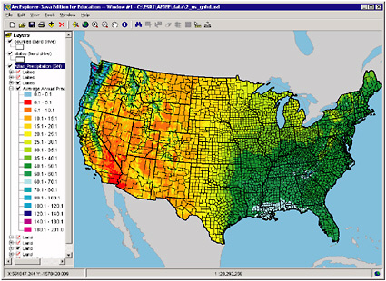 FIGURE 9.1 The U.S. map, showing average annual precipitation superimposed on county and state boundaries, is based on a built-in project in ESRI’s ArcExplorer Java Edition for Education. |
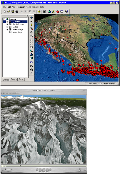
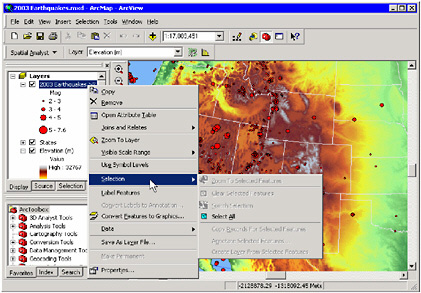 FIGURE 9.2 This map of elevation and earthquakes, superimposed on state borders, is part of a project generated by ESRI’s ArcView 9. The user interface has been customized by adding a toolbar (Spatial Analyst) and moving the navigation toolbar into a vertical position between the Table of Contents (at left) and the map, facilitating the selection of commonly used tools. The ArcToolbox palette has been engaged and positioned below but in line with the Table of Contents.
|