
Appendix C
Digital Geographic Data Available in the United States
C.1 INTRODUCTION
Human curiosity about our world has generated philosophical and practical questions about nature, exploration, organization, and use of Earth’s space. As a result, geographic thinking, observation and the collection of information about Earth, and mapping of Earth’s features are a part of the earliest civilizations. The quest for geographic knowledge to inform our curiosity and to direct our actions is reflected in maps that address pressing spatial questions. Such questions have become more complex during the past century due to discovery, technology, and human treatment of the physical environment, including the rapid industrialization and concomitant urbanization of the globe. They also have taken on a more pressing drive for fast answers. Fortunately, our ability to acquire, store, retrieve, visualize, and analyze large geographic databases, containing location-specific identifiers that link features to geography, also has increased dramatically. In fact, it might be argued that technological improvements fostered data generation efforts by the end of the twentieth century. Today, digital devices enable the rapid acquisition and maintenance of an incredible range of geographic databases, a vast inventory of information about Earth, ranging from geodemographic descriptors to well-defined uses of small plots of land. Barely recognized by local planners a quarter century ago, geographic information systems (GIS) are now in general use across the United States.
As we enter a discussion of geographic data licensing, it is necessary to be aware of the types of data now available. The purpose of this chapter is to classify geographic data to permit discussion of a broad range of geographic data types now available in the United States from a variety of sources, public and private. We broadly classify geographic data types by their origin, resulting from either processes of the natural world or human action. As any taxonomy, ours has fuzzy parts. We know that the physical and human worlds are intertwined and that human actions influence physical process and patterns. Nonetheless, a simple taxonomy allows for easy discussion of the various types of geographic data. We also associate federal agencies with particular types of geographic data, recognizing that agencies with parallel or overlapping functions at other government levels also use such data types.
C.2 GEOGRAPHIC DATA AND THE PHYSICAL WORLD
Numerous features and variables are used to describe, visualize, analyze, and monitor Earth’s physical processes, patterns, and conditions. Of growing importance is the use of geographic data. In the United States, numerous government agencies and commercial firms participate in the acquisition and applications of geographic data. Below, we summarize features related to weather, hydrology, elevation, geology and physical geography, energy, and hazards that are available as geographic data.
C.2.1 Weather/Meteorological Data
Meteorological processes and weather influence biological and ecological systems, including the growth and health of species. Weather and climate also affect long-term geological and geomorphic processes and the physical geography of Earth’s surface. Table C-1 reports four weather features—precipitation, temperature, humidity, and winds—that often are presented as geographic data and used to assess current conditions and predict future ones. Federal agencies acquire and apply these geographic data. In addition, government agencies contract for commercial services related to data acquisition, and so, the private sector also is a stakeholder in these processes.
TABLE C-1 A Classification of Geographic Data Available in the United States: The Physical World
|
Topic |
Features |
Examples of Federal Stakeholdersa |
|
Weather |
Precipitation, temperature, winds, and humidity |
DOE, FEMA, NOAA |
|
Hydrology |
Water bodies, drainage/subsurface, wetlands, and watershed/drainage basins |
EPA, FWS, NRCS, USDA, USGS |
|
Elevation/bathymetry |
Slope, contours, aspect, and digital elevation models (DEMs) |
BLM, NOAA, NRCS, USDA, USGS |
|
Physical geology and physical geography |
Bedrock geology, surficial geology and geography, soils, and land cover |
BLM, DOE, NRCS, USDA, USGS |
|
Energy resources |
Coal deposits, oil fields, natural gas reservoirs, geothermal fields, other natural resource deposits |
BLM, DOE, EIA, NRCS, USGS |
|
aBLM = Bureau of Land Management, DOE = Department of Energy, EIA = Energy Information Administration, EPA = Environmental Protection Agency, FEMA = Federal Emergency Management Agency, FWS = Fish and Wildlife Service, NOAA = National Oceanic and Atmospheric Administration, NRCS = Natural Resources Conservation Service, USDA = U.S. Department of Agriculture, USGS = U.S. Geological Survey. |
||
C.2.2 Hydrology
A large number of environmental surface features related to water and its movements occur as geographic data. At least six federal agencies are stakeholders in their acquisition and use. Surface water bodies in the United States include rivers, streams, lakes, ponds, reservoirs, and human-made canals. The subsurface (drainage) includes all areas into which water drains and water in various locations below Earth’s surface, such as wells or springs that emit water and aquifers (underground beds).
An additional water-related category includes lowland areas saturated by water (e.g., marsh, swamp) and considered wildlife natural habitats designated as wetlands. Finally, watersheds/drainage basins are areas draining to a common waterway, such as a stream or lake (see Table C-1).
In addition to the natural features, monitoring, planning, and intervention activities require specially designated geographic regions, or districts, that are reported as geographic data (see Table C-1). Geographic data facilities devoted to measuring water composition, flow rates, and depth include water-monitoring facilities, dams, gauging stations, and rainfall/ precipitation stations. Geographic regions, specified by local, state, or federal actions, including water districts, floodplains, and historic flood zones and points that have recorded 100-year and 500-year floods, fall into this category.
C.2.3 Elevation and Bathymetry
Elevation and bathymetry are the heights above or below sea level, respectively. Related features include slope, contours, and DEMs. Natural landscapes contain sloping surfaces, implying curvature of surface as one moves from location to location. Slope is a measure of angular change between elevation points on a continuous surface. Contours are lines on a map that connect points of equal elevation. A DEM is a database of point measurements of elevation at regular intervals. The most common forms include feature points separated by 10 meters, although small-scale maps use larger intervals. Contour line and slope surfaces typically are derived from DEMs. All three features associated with elevation can be imported into most GIS.
C.2.4 Physical Geology and Physical Geography
The natural environment includes surface and subsurface features that result from long-term Earth processes and are important for understanding the effects of human actions. Together, these features constitute the physical geology and physical geography of the natural environment. Included in such features are bedrock geology, surficial geography and geology, and soils and land cover (see Table C-1).
Bedrock geology, including features that are located beneath unconsolidated, depositional matter and soils, may be important for engineering and construction projects. Surficial features refer to various landforms and depositional characteristics of Earth’s surface. Soils are classified by
their physical characteristics and vary widely. Despite limited sampling to verify the generalized areas of similar soil types, digital soils maps are widely used for planning and development applications.
C.2.5 Energy Resources
Energy resources hold substantial locational importance. Among the geographic data available for this category are coal deposits, oil fields, geothermal fields, and natural gas reservoirs. The latter include a number of gases typically found in association with petroleum deposits, including methane, ethane, propane, and butane.
C.2.6 Natural Hazards
Naturally occurring events can become hazardous when human settlements coincide with their locations. These natural hazards include tornadoes, hurricanes, floods, volcanoes, and earthquakes.
C.3 GEOGRAPHIC DATA AND THE BUILT ENVIRONMENT
The built environment constitutes the human geography at Earth’s surface. Both visible and invisible features are important ways of organizing living space. These include overt structures that define cultural landscapes and invisible boundaries that reflect politic, economic, and locational decisions. These data are broadly summarized into eight major categories (Table C-2): transportation-related, institutional locations, energy-related infrastructure, administrative and legal, hazardous locations, business, communications, and health.
C.3.1 Transportation
Geographic transportation data are related to infrastructure, routing, roadway descriptions, and special projects. Transportation technology was crucial to the early growth of the U.S. economy and metropolitan system. It continues to be a crucial part of a successful economy. The U.S. transportation infrastructure is complex and contains both national and regional linkages and features that are points and areas distributed within and around its infrastructure. The linkages contain major and minor roads
and highways, including the U.S. Interstate Highway System, and a national network of railways that link major cities and resource areas with production areas. Other transportation linkages include the intracoastal waterways—the canal and river systems that serve as commercial linkages—bridges that connect any of these linkages, and local and regional transit arteries, such as subways.
TABLE C-2 A Classification of Geographic Data: The Built Environment
|
Topic |
Features |
Examples of Federal and Other Stakeholdersa |
|
Transportation |
Infrastructure, routing, roadway descriptions, and special projects |
ACE, BTS, CENSUS, DOT, EPA, FAA, FWS, FHA, FTA, FRA, NRCS, NHTSA, NOAA, NASA, USDA |
|
Energy generation sources and transmission |
Generation: hydroelectric facilities, oil rigs, wind farms, nuclear power plants |
ACE, BLM, DOE, EIA, FEMA, USGS |
|
|
Transmission: transformers and transfer stations and power transmission lines |
DOE, EIA |
|
Institutional |
Colleges/universities, schools, libraries, churches, hospitals, nursing homes, parks, industrial sites, historical sites/districts |
BLM, Census, EPA, USGS |
|
Administrative and legal |
Legal, legislative, census, geography and special-purpose boundaries, cadastral |
Census, HUD, Commerce |
In addition to these major transportation arteries, other transportation points and areas that constitute important components of the overall infrastructure include airports, bus stations, railroad stations, highway exits and toll plazas, service and rest areas along highways, and gasoline and fueling stations. Finally, port facilities constitute an important part of the U.S. transportation infrastructure and thus are important elements of geographic data.
A significant part of transportation is the repetitive vehicular travel along paths and corridors. Such routes apply to public and private carriers,
and schedules on such routes are well established. Bus, truck, rail, ferry, and airline routes are examples of features that are captured as geographic data.
Some geographic data features depict important aspects of roadways. Line feature data depicting the approximate center of a road is an important example and is a data element built into the U.S. Census Bureau’s Topologically Integrated Geographic Encoding and Referencing system (TIGER) files. Finally, special transportation projects are sometimes captured as geographic data. An example is a construction project undertaken by DOT at a particular location.
Geographic transportation data are extremely comprehensive, and therefore, it should come as no surprise that more than a dozen federal agencies (Table C-2) are stakeholders in the acquisition and use of these data.
C.3.2 Energy Generation and Transmission
Power sources and their transmission are vital to the national economy. In this category, we include human-made facilities and the means of their transmission to intermediate points and to end users. Examples of human-made energy generation locations include hydroelectric and nuclear power plants, oil rigs, and wind farms. Examples of geographic data describing features of energy transmission include transformers, transfer stations, and transmission lines. Such data play multiple roles in calculation efficiencies, creating cost-saving alternatives, and monitoring systems.
C.3.3 Institutional
Institutions play vital roles in perpetuating culture; educating the population; and providing public and private services, places to worship, and historic preservation. As such, this is a broad category containing numerous cultural features that are part of the built environment that are of significance because they provide continuity for the long term, shaping cultural beliefs and traditions, and facilitate some daily behaviors of Americans.
Examples of such institutions appear in geographic databases, including (1) places of learning such as colleges/universities, schools, and libraries; (2) medical and extended-care facilities such as hospitals and nursing homes; and (3) other locations, including industrial sites, parks, and historic landmarks and sites (see Table C-2). In the latter case, a National Register exists as part of a federal program to coordinate the
identification, evaluation, and protection of American historic and archeological resources.
C.3.4 Legal and Administrative
The U.S. government has created or recognized legal boundaries that provide the framework for a host of government actions and individual behaviors. These legal and administrative boundaries are political boundaries in that they establish the area in which certain laws and responsibilities may take place under the jurisdiction of elected or duly appointed officials. These geographic data include state, county, city, town, and place definitions that have legally or administratively recognized boundaries.
Within the legal boundaries are a set of legislative boundaries that provide the framework for representative government. These include election districts, congressional districts, assembly districts, and senate districts. These not only form the geographic means of representation; they also are utilized for voting trend analysis and postelection assessments.
U.S. Census Bureau TIGER files contain another form of administrative boundary that is widely used in census geography. These files contain the previously discussed legal and legislative boundaries, such as local school districts, and also contain a hierarchy of urban geographic zones, including metropolitan statistical areas, census tracts, block groups, and blocks suitable for a wide range of analyses. These boundaries often are utilized to create special-purpose areas/districts and supporting geographic databases. Examples include low- to moderate-income designations in urban centers, economic development and enterprise zones, and agricultural districts within counties.
There are many other types of special-purpose districts created from census or cadastral maps. An example is the local zoning map, which creates geographic areas of permitted land-use activities and limits other types of land use and development elsewhere.
Cadastral refers to geographic units of land that have been legally defined by professional survey standards for the purpose of land ownership. Thus, a great deal of geographic data has been accumulated on a local basis for the purposes of physical description and local taxation. Although the volume of data collected and maintained may vary, most systems contain land dimensions and area, number and type of structures, value of the land, and value of the structure. Of all the data described thus far, these are the only data collected, managed, and controlled by local administrative and legal rules.
C.3.5 Hazardous Sites
Environmental awareness and governmental actions have resulted in the collection, maintenance, and analysis of data on hazardous sites and their features. For example, EPA maintains a network of monitoring sites where water and air samples are collected routinely for analysis. The locations of nuclear power sites are also maintained as geographic data.
Environmental issues related to the disposal and storage of human waste have also resulted in geographic databases. For example, since harmful chemicals can seep into groundwater where refuse is stored, landfills are reported as geographic data. Similarly, the use of chemicals for fertilizers, sites of toxic releases and accidents, the use of herbicides, and the deposition of manure are all included in geographic database inventories maintained by USGS, EPA, and other agencies.
C.3.6 Business Geographic Data
Businesses increasingly use geographic data to target and evaluate markets, conduct site location analyses, and assess store performance. Geodemographic data are essential to these enterprises and represent census geography and special market areas. In addition to demographics, the location of competing retailers and affiliated businesses are typically geocoded geographic databases available from private data providers used in various types of business analyses.
C.3.7 Communications and Geographic Data
The locations of TV stations, fiber-optic lines, and forms of telegeography have become available in recent years from private vendors and are widely used in the communications industry. Vendors include Primetrica, Inc., and Equinix.
C.3.8 Geographic Health Data
The geographic distribution of disease and the use of health care indicators in geographic analyses are two examples of geographic health data. The availability of health indicators, such as low birthweight, in association with toxic waste storage, has led to equity studies of environmental health issues. Also, the distribution of disease and health
conditions, such as HIV/AIDS, are important examples of geographic health databases.
C.4 IMAGES AS GEOGRAPHIC DATA
Geographic data capture and use are based on two models: raster and vector. Vector data represent real-world themes such as addresses (points), road networks (lines), or land parcels (polygons). The location and shape of the polygon, line, or point is determined by the coordinate position (e.g., latitude/longitude) of its node(s). Many of the data types in Tables C-1 and C-2 are examples of vector data. Raster data organize a geographic space into cells, with each cell containing attribute measures (e.g., reflectivity, elevation, frequency, concentration). Each cell in the grid is of equal size and the cell density establishes the spatial resolution of the grid (see Figure C-1). This class of geographic data includes a large range of layers derived from digital aerial photographs, x rays, sonar, and thermal images remotely detected by sensors on aircraft or satellites. Commercial images vary widely in resolution, cost, and use. A high-resolution aerial photo can provide a resolution whereby each pixel represents a square on the ground of only a few centimeters on a side, whereas the highest resolution commercial satellite images have pixels that represent squares measuring 0.62 meter on a side.
Images have a number of uses related to geographic data. Sometimes, for example, they provide the basis for “heads-up digitizing” of planimetric features (building footprints, streets, etc.). Images also are frequently used as “backdrop” for the display of other geographic data. Images also can be utilized for the derivation of land-use and land-cover layers for multiple uses.
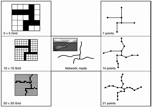
FIGURE C-1 A road network represented at three spatial resolutions by raster (left) and vector (right) data. SOURCE: I. Heywood, S. Cornelius, and S. Carver, 2002, An Introduction to Geographical Information Systems, 2nd Ed., Upper Saddle River, N.J., Pearson Education, p. 53, ©2002. Reproduced with permission of Pearson Education, Inc., Upper Saddle River, N.J.


