
3
MAP REQUIREMENTS
Several questions sought to accomplish two goals: to determine the requirements of geoscience map users regarding map format, including style and scale, and to determine the relative importance of various map types in the users’ work, including the importance of maps produced by the users themselves.
To accomplish this, geoscience maps were divided into three major categories: geological, geophysical, and groundwater. This subdivision was developed because of obvious differences in format requirements for each, and because these three broad subdivisions include most of the geoscience map types used in the United States.
Derivative maps were not considered, because most are the product and include elements of the three categories listed, and because most are self-produced.
The relative importance respondents placed on printing styles is shown in Table 9 and Figure 5. Full-color geologic maps are clearly the type of geoscience maps users want most.
The total responses for each map type—1258 for geological, 722 for geophysical, and 350 for groundwater—might be interpreted as an approximation of the relative need for each.
That 30 percent of the 1258 geologic map responses indicated black-and-white maps as “extremely important” is somewhat surprising because of the greater detail and ease of use offered by colored geologic maps. The question, however, asked respondents to consider that it takes 12 to 18 months to process maps for publication as full color, 6 months for one color, and 3 to 4 months for black and white, possibly accounting for this unexpected importance placed on black-and-white geologic maps. Written comments to question 15 also indicate that the unexpected impor-
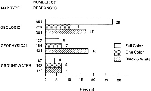
FIGURE 5 Printing styles favored for different geoscience map types.
tance placed on black-and-white maps largely may be a reaction to the length of time needed to produce a colored geologic map. In addition to the extra time needed to process the maps, colored maps require extra field time to produce the degree of quality to justify the high cost of colored map printing. Most information portrayed on geophysical and groundwater maps, on the other hand, is accurately and concisely portrayed by black-and-white maps.
Data relevant to the importance of base map elements are given in Table 10 and Figure 6. For geological and geophysical maps, topography, by more than a factor of 2, is considered the most important type of base. Since composite bases include topography, the sum of topographic and composite responses indicates an even greater perceived importance of the topographic base. For groundwater maps, drainage was a close second to the topographic base in importance.
Percentages shown in Table 10 are percentages of the total response to question 6, and reflect the importance map users place on base-map-type combinations relative to other combinations.
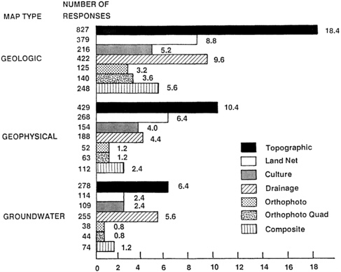
FIGURE 6 Responses indicating base types considered “extremely important” for each of three geoscience map types.
Scale is perhaps the most important aspect of map format bearing on the uses to which the map will be put. The data relevant to map scale are given in Tables 11 and 12 and Figure 7.
For all three map types, users emphasize the importance of scales of approximately 1:62,500 or more. Except for the low interest in medium-scale groundwater maps, all map types received a corresponding decline in interest with decline in scale. For groundwater maps, medium scale was of low importance, small scale was moderate (32 percent), and regional scale was zero.
The percentages in column 1 of Table 12, and comparison of the number of respondents in each column of Table 11, indicate a recurring though subtle point emphasized throughout the results of this survey—that geologic maps are the geoscience map type given most attention by the respondents, and by inference, the type in greatest demand by the user community.
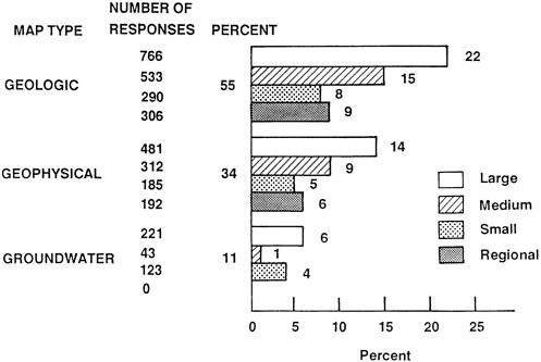
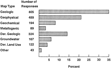
Table 13 and Figure 8 show the relative importance respondents placed on different types of geoscience maps that they produced themselves.
Every organizational group considered geologic maps by far to be the most important map type. Geophysical maps were second overall, largely because of their heavy usage by the petroleum industry, but they scored lower than second place with two of the organizational groups. Many of the self-produced maps within the government group, and some within the academic group, are eventually published, and therefore become available to the general user community. The majority of self-produced maps are made by industry, however, and almost none of these are published.


