
4
GEOSCIENCE MAP NEEDS
The largest single element of the questionnaire was devoted to ascertaining by geographic area the mapping needs in the United States for both the present and the future. In addition, information was sought, by region, on what scales would be most needed for future maps. The nation was divided into 41 major geologic/physiographic provinces outlined on the map in Appendix A. The geographic needs were addressed in a single question (question 12), which was designed to determine (1) the importance of each province to the respondents’ current work, (2) the importance that should be given each province for future geoscience mapping, and (3) the map scales that will be needed for future geoscience maps in each of the provinces. Although the form of the first two questions is not identical with respect to the specific information requested, they are similar enough to serve as a basis for comparing changes in current and future geoscience mapping needs within each province.
Geographic information on map needs from question 12 is analyzed in terms of the number of “extremely important” responses. Raw data for the responses to current and future needs are given in Appendix C (Tables 14 through 16). In the maps and text that follow, and in Appendixes D through F, the “extremely important” responses are correlated with information from other questions and presented in terms of; (1) the type of organizational group (employer type) with which the respondent is associated (Appendix D), (2) the type of work activity in which the respondent is engaged (Appendix E), and (3) the respondents’ associational affiliation and consequent implied purpose of map use (Appendix F).
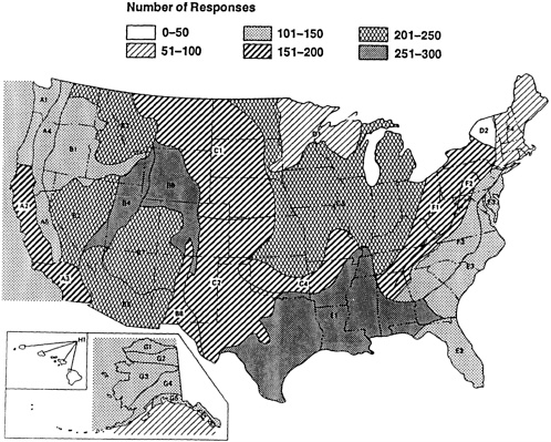
In addition to Appendix C, the “extremely important” responses indicating the current level of emphasis placed
on each province are shown graphically in Figure 9, and, for future needs, in Figure 10. The difference between the current level of importance and the future level of importance is also given in Appendix C (Table 14) and in Figure 11. Although analyses of these data are based only on the “extremely important” response categories, which are interpreted to reflect the most pressing future demand (needs) of map users, addition of weighted “moderately important” responses would not change appreciably the relative ranking of the provinces. Most geoscience map users are somewhat restricted geographically in their work, probably most working in only a province or two, which accounts for a high background level of the “not important values” for this question.
The conterminous United States onshore provinces are discussed in terms of current and future needs, followed by a brief analysis of the changing needs. Because of the special, and in some cases unique, needs and problems associated with the Alaskan and offshore provinces, each is discussed in a separate section. In all sections, the provinces are identified by the letter-number code shown on the map of Figure 1, and listed in question 12 (Appendix A).
CONTERMINOUS UNITED STATES
Current Needs
In terms of current map needs, the 10 most important provinces, based on all “extremely important” responses to question 12 are, in decreasing order:
Gulf Coastal Plain (E1)
Basin Range-Rocky Mountains Foreland Province (B6)
Central Rocky Mountains Thrust Belt (B4)
Basin Range (B2)
Northern Rocky Mountains Thrust Belt (B3)
Midcontinent Region (C3)
Colorado Plateau (B7)
Southern Great Plains (C2)
Southern Rocky Mountains (B5)
Northern Great Plains (C1)
The Gulf Coast (E1) is the single highest ranked province for overall current needs. Six of the top-10-ranked provinces are in the Basin Range-Rocky Mountain, and three are in the Great Plains-Midcontinent. The
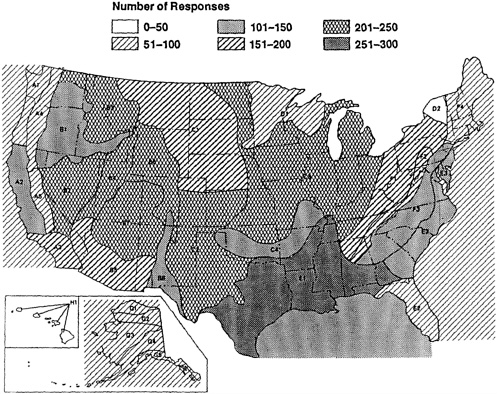
concentration of these provinces in the top ranking strongly reflects the influence of industry-employed respondents, particularly petroleum exploration, which represented such a large proportion (60 percent) of the respondents. Of the five provinces that were top-ranked by the industry-employed group, only one differed in order from this overall ranking by all organizational groups.
The current map user needs by region are given in Appendixes D through F) in terms of organizational group, work activity, and professional affiliation. The hazard mitigation category has only four provinces listed, because only four provinces were indicated as “extremely important” by more than two respondents.
Future Needs
Responses to the second part of question 12 identified the following 10 provinces, ranked in descending order of importance, in which geologic mapping is most needed in the future:
Central Rocky Mountains Thrust Belt (B4)
Basin Range-Rocky Mountains Foreland Province (B6)
Gulf Coastal Plain (E1)
Basin Range Province (B2)
Northern Rocky Mountains Thrust Belt (B3)
Southern Rocky Mountains (B5)
Colorado Plateau (B7)
Midcontinent Region (C3)
Southern Great Plains (C2)
Appalachian Fold and Thrust Belt (F2)
The Basin Range-Rocky Mountain provinces dominate the list, which includes only four provinces from outside that region—two from the Midcontinent, and one each from the Coastal Plain and Appalachian regions. Map needs of industry are strongly reflected in this ranking, as they were in the ranking of present-day map requirements. The relative importance of future needs by region is given in Appendixes D through F in terms of organizational group, work activity, and professional affiliation.
FUTURE NEEDS BY ORGANIZATIONAL GROUPS
Industry respondents indicated Basin Range-Rocky Mountain provinces to be the most important in terms of future
map needs. One Gulf Coast province ranked third, and one Great Plains province tied a southern Basin Range province for fifth. The academic group indicated all but one province to be in the Basin Range-Rocky Mountain region for greatest importance for future map needs, but the consulting group ranked only one Basin Range-Rocky Mountain province in their top five. All provinces indicated by geologists with the federal government to be of greatest future importance fell in the Basin Range-Rocky Mountain region. Of the 20 provinces (23 with ties included) identified by the four organizational groups, i.e., the five most important from each group, 16 were in the Basin Range-Rocky Mountain region. The Central Rocky Mountain Thrust Belt (B4), the Foreland province (B6), and the Basin Ranges provinces (B2) were considered to be the most important in terms of future map needs.
FUTURE NEEDS BY WORK ACTIVITY
Broken down by work activity, the Basin Range-Rocky Mountain provinces are again identified as the region considered most in need of geologic mapping in the future. The Great Plains-Midcontinent provinces, except for the northern part, also received strong interest, especially from respondents involved in resource development. Respondents involved primarily in resource exploration and scientific research indicated all future mapping needs to be in the Basin Range-Rocky Mountain provinces, except for the Gulf Coast province, which was ranked fifth by each group. Those involved chiefly in engineering ranked the southern three Appalachian provinces as most important, the only group showing significant interest in this area.
Respondents whose principal work involves hazard mitigation not unexpectedly ranked the tectonically active West Coast provinces as most in need of geologic mapping in the future. Probably reflecting the need for maps in an area of identified resources, those respondents involved in resource development ranked three of the Great Plains-Midcontinent provinces in the top five.
FUTURE NEEDS BY PROFESSIONAL AFFILIATION
The future needs ranking of areas by professional affiliation, as might be expected, strongly mirrors the ranking by work activity, and to a slightly lesser degree,
that by organizational group. The chief work done by the membership of a few professional societies, however, is highly focused geographically by the specific needs of relatively restricted areas. The geologic map needs of these groups sharply contrast with the needs of the overall user community, as indicated by the rankings based on all responses. The membership of AEG, AICP, and AWRA are points in case; these groups are concerned with problems associated with tectonically active areas and rapidly developing areas where groundwater supplies are important. Members of these three professional societies, unlike most of the others, indicate almost all their needs to be in the westernmost United States, where hazard and groundwater problems are major concerns that, in varying degrees, affect almost all land-use decisions.
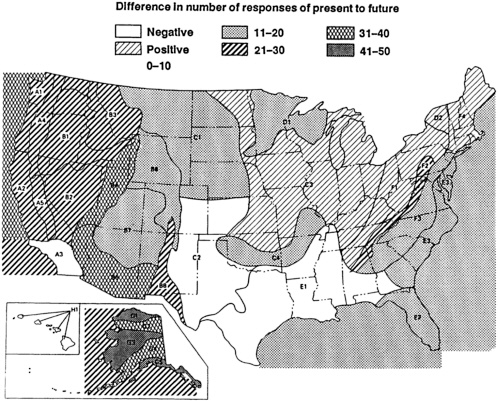
COMPARISON OF THE PRESENT AND THE FUTURE
Information from question 12 afforded a basis on which to rank both the importance of each province to the current work of the respondents and the importance that should be given each province for future geologic mapping. Comparison of these rankings and of the overall responses provides a basis for estimating overall changes in mapping needs that will occur in the future, and also, geographically, where the relative shifts in levels of need will occur.
Analysis of the overall responses indicates that, for 38 of the 41 provinces, an increase in the level of importance of geologic mapping ranging from 2 to 55 percent will be needed in the future. The two exceptions are the Gulf Coastal Plain (E1) and the Southern Great Plains (C2) provinces. The Gulf Coastal Plain is ranked as the most important province in terms of current geologic map needs, but a 12 percent decrease in the level of future mapping may be anticipated. The Southern Great Plains is also ranked high in terms of current map needs, but a 2 percent decrease with respect to future needs is anticipated.
The relative ranking of the top 10 provinces reflects a relative shift from the Gulf Coast-Midcontinent to the Basin Range-Rocky Mountain provinces. As shown in Figure 11, however, future map needs in the former remain high. Four of the provinces, all in the Basin Range-Rocky Mountain region, retained their relative ranking.
The data shown in Figure 11 suggest that geoscience mapping needs may have peaked for the Gulf Coastal Plain,
may be at or near the peak for the Southern Great Plains, and may be approaching the peak for the Midcontinent.
Seismic and other hazard-related problems undoubtedly account for the strong increase in the Western Cordillera region, in addition to other problems related to rapid population growth. The large increase in future map needs for the Basin Range-Rocky Mountain region may reflect a partial shift in resource exploration and development from the Gulf Coast-Midcontinent regions. The Appalachian region showed an overall increase in future map needs, but not as high as western areas.
In terms of organizational groups, all except those engaged in consulting indicated significantly greater geologic map needs in the future. Broken down by work activity, only those engaged in engineering specified a decrease in future geologic map needs.
ONSHORE ALASKA
Onshore Alaskan provinces were moderately ranked in importance for current needs. The North Slope (G1), having considerable petroleum interest, was ranked only slightly above the province containing the greatest population concentration, Southeastern Alaska (G5). The other three provinces were only slightly lower than these two in their numerical ratings. In terms of future needs, however, the Alaskan provinces, as a group, showed a greater increase than in any other part of the United States, with percentage increases that range from 41 to 50. Nationwide, no other provinces with more than 100 responses showed an increase in map needs greater than 35 percent, and only two in the Basin Range-Rocky Mountains and two in the Western Cordillera showed more than a 20 percent increase.
Probably the only reason Alaska does not appear in the top-10-ranked provinces is that the number of respondents residing there is relatively low.
Academic-employed respondents ranked the Alaskan (and about equally the Basin Range) provinces highest for future increases in geologic map needs.
Consultants indicated slight increases for all Alaskan provinces, in marked contrast to a general decrease for future needs in the conterminous United States.
Federally employed respondents indicated a significant increase in the need for geologic maps in Alaska, and industry respondents ranked Alaska second only to the
Basin Range-Rocky Mountain provinces for future needs.
Those respondents engaged in work related to the petroleum industry ranked all Alaskan provinces very high for future needs. Engineering geologists and planners were the only group to rank the Alaskan provinces low in terms of their map needs for both the present and the future. Hydrology respondents ranked Alaska low at present, but with increased future needs. Geophysicists, engaged in work largely related to the petroleum industry, indicated future increases to be higher than Alaska only in the Western Cordillera and Basin Range-Rocky Mountain provinces. Geologists engaged in mineral-deposits-related geology indicated moderate Alaskan geologic map needs at present, and showed no significant increase necessary in the future.
OFFSHORE AREAS
With the exception of the Atlantic Gulf Coast (J1), the offshore provinces were ranked moderately low in their current level of importance, but, again with the exception of the Atlantic Gulf Coast (J1), responses indicated sizable future increases. Academic respondents indicated a moderately high level of importance at present, with moderate increases in importance for the future. Consultants ranked offshore provinces low with slight, if any, future change. Federal respondents ranked them low at present, with significant future increases in importance. Industry ranked them low, with moderate increases in the future, the largest increase being in the Pacific Ocean (I1) and Southern California Borderlands (I2), and the Alaskan Waters (K1, K2, and K3). Those respondents engaged in resource planning ranked offshore areas moderately low, with only the Pacific Ocean (I1) showing much future increase in importance. Resource exploration responses likewise ranked them moderately low currently, but with significant future increases, especially in the Pacific Ocean (I1) and the Southern California Borderlands (I2). Resource development responses ranked offshore areas moderate, with future increased importance, especially in the Alaskan Waters (K1, K2, and K3). Those engaged in scientific research ranked them moderate, with moderate future growth in importance, and those engaged in engineering considered the offshore areas relatively unimportant for the current and future. Respondents concerned with hazard mitigation had little current or future
interest except for considerable interest in the Southern California Borderlands (I2).
Responses from those engaged in geology related to the petroleum industry rated offshore areas moderately low at present, with large future increases, especially in Alaskan Waters (K1, K2, and K3) and to a lesser degree in the Southern California Borderlands (I2). Engineering geology respondents had a low, stable level of assigned importance. Urban and regional planners generally had almost no interest in the offshore areas, except for I2 and J3, in which they expressed slight interest. Hydrologists and economic geologists showed an overall low interest in the offshore areas, both for the present and for the future. Geophysicists engaged in work largely related to the petroleum industry indicated a moderately low level of importance, with little future increases, except for the Atlantic Ocean provinces, in which fairly large future increases would be needed. Academic stratigraphers and paleontologists indicated a moderately high level of importance placed on offshore areas, but with little future increase except in the Chukchi-Beaufort Seas (K1). Responses from mining engineers and those in the mineral industry indicated a low interest at the present, but a large future increase in needs for the Pacific Ocean (I1), Southern California Borderland (I2), and Gulf Coast (J2), and moderate increases for offshore Alaska.
MAP SCALES FOR FUTURE MAP NEEDS
Part of question 12 asked respondents to designate which of several scales would be most important for future geologic mapping in the various geographic regions. Respondents indicated a far greater need for larger scales in all but a few of the provinces. Appendixes D through F show the “extremely important” responses indicating preferred scales for future geologic mapping in the conterminous United States only, in Alaska only, and in all regions.
The importance of the smaller scales is greater in Alaska, probably because large areas are still essentially unmapped and information is needed as soon as possible. For offshore regions, the indicated needs appear to be essentially equal in all four scale classes (about 25 percent each). Preferred scales by organizational groups are shown in Appendixes D through F.
Except for a relatively strong response from federal workers for intermediate scales, the breakdown by organiza-
tional groups is very similar to the response for all regions. All of the groups expressed the greatest need for very large scale in the future to be in the Great Plains-Midcontinent regions. Responses to scale preference broken down by work activity are shown in Appendix E.
Most of the work activity groups mirror the general response given for all regions. The need for very large scale maps by those involved in engineering and hazard mitigation work stands out from this general response, however. Preferences within work activities were indicated for specific regions that contrast with the overall response for that particular activity. Respondents engaged in resource planning, for example, expressed relatively great need for the very large scale maps in the Appalachians east to the Atlantic Coastal Plain. Responses from those engaged in resource exploration work emphasized the need for 1:24,000 to 1:62,500 scale maps in the Basin Range-Rocky Mountains, and scales greater than 1:24,000 in the Southern Great Plains and the Gulf Coast. For respondents engaged in resource development, scales larger than 1:24,000 are preferred for future maps in the Pacific Northwest, northern California, and the Basin and Range.


