
D
Case Studies
The committee identified several representative case studies that illustrate various aspects of the utilization of environmental satellite data.
OZONE DATA UTILIZATION: PAST, PRESENT, AND FUTURE
A Brief History
Ground-based ozone measurements were first taken in the 1930s. In the 1960s, a primitive, multiband ultraviolet (UV) photometer sensitive to ozone was flown on an Air Force satellite. In August 1970, the National Aeronautics and Space Administration (NASA) launched Nimbus-4, a meteorological research-and-development (R&D) satellite, carrying a backscatter ultraviolet (BUV) instrument for globally monitoring the vertical distribution and total amount of atmospheric ozone. The early interest in ozone was for possible meteorological applications and science—ozone was not yet an environmental issue.
The Early algorithms followed the radiative transfer work of Dave and Mateer1 developed for ground-based measurements of ozone. The profile retrievals used the Umkehr (reversal) technique, which provides important vertical ozone information
by using a spectrophotometer to measure UV radiation. In this approach, scattered UV radiation is observed at multiple wavelengths—some strongly absorbed by ozone and the others weakly absorbed. The satellite total-column ozone retrievals were similar to the ground-based Dobson band-pair technique. The Nimbus-4 system did not include an onboard radiometric calibration source or stability monitor, and the BUV hardware was a direct current (dc) system. While consequent calibration challenges combined with problems concerned with the South Atlantic Anomaly and the nadir-only views gave a rough estimate of the global ozone climatology, the 2 years of measurements provided key lessons for later flights, which required and provided better coverage and accuracy.
The next-generation ozone measurements were obtained from the very successful Nimbus-7 Solar Backscatter UV (SBUV) and Total Ozone Mapping Spectrometer (TOMS), launched in October 1978. For more than 10 years the Sun-synchronous SBUV and TOMS on Nimbus-7 provided daily, near-global (the nighttime polar regions were not observed) maps and ozone profiles along the satellite track. These measurements included detailed mapping of the Antarctic “ozone hole” after it appeared. Improvements to the flight hardware included an alternating current (ac) chopper, a shared solar diffuser for reflective radiometric calibration, and swath coverage in the case of TOMS. The nature of BUV sensing (viewing the solar spectral irradiance and Earth’s spectral radiance, the Earth bidirectional reflectance distribution function (BRDF), through the same optical path) mitigated many calibration challenges. In addition, examination of the consistency of multiple band pairs (six UV wavelengths were sampled by the TOMS) helped to take out the total ozone drifts in time. The community is still struggling for consistency in the profiles in which absolute BRDF knowledge is used.
The Nimbus-7 observation time series was of fundamental importance. The more-than-10-year duration of the data set provided a unique climate record because of its long-term accuracy. The onboard calibration capability helped provide for stability of the measurement record.
The timing of the Nimbus-7 mission included a period of rapid deepening and discovery of the ozone hole. The significant lowering in total ozone over Antarctica caused a rethinking of the autonomous ground quality-assurance programs that otherwise would reject the “unrealistic” low values. The success of the mission exceeded expectations—exemplified at the 32,768th orbit, when the two-byte word for the orbit number no longer sufficed.
The Nimbus-7 SBUV legacy (November 1, 1978, through June 21, 1990) was extended into the operational realm starting with the NOAA (National Oceanic and Atmospheric Administration) -9, -10, -11, -14, -16, and -17 satellites, the present-day Polar-orbiting Operational Environmental Satellites (POESs). These satellites carry the SBUV/2, which includes an onboard solar diffuser stability monitor to help
characterize the time-dependent radiometric calibration changes. Following the Nimbus-7 TOMS (November 1, 1978, through May 6, 1993), subsequent NASA research flights included Meteor-3 (August 22, 1991, through November 24, 1994); Advanced Earth Observation Satellite (ADEOS) (July 25, 1996, through June 28, 1997); and Earth Probe (EP) (July 25, 1996, to the present). The most recent EP TOMS uses a solar diffuser carousel to ensure long-term measurement stability knowledge and control.
Corresponding improvements in the ground algorithms kept pace with hardware improvements on the series of NASA research flight missions. With the urgent need to improve measurement accuracy and precision, the ongoing validation activities revealed anomalous ozone amounts under certain conditions (e.g., the presence of aerosols). Analysis into the root causes of these anomalies led to the inception of new products that were by-products of the “noise” in the ozone. For example, extracting information about aerosol optical thickness and single-scattering albedo was a significant development from this measurement record. Unlike other techniques (e.g., Advanced Very High Resolution Radiometer [AVHRR]-based), the TOMS aerosol measurements could be made over ocean and land and under clear and cloudy conditions. In addition to aerosol information, TOMS today also produces information or fields of tropospheric ozone, UV irradiance at the surface, and volcanic sulfur dioxide (SO2).
Today, because of the iterative improvements from validation, refinement, and revalidation—in what is called a spiral development process—the TOMS and SBUV products stand at Version 8. For example, Version 6 improved the calibration, Version 7 accounted for aerosol effects, and Version 8 refined the solar zenith angle dependence. For each version change, a retrospective reprocessing of the entire measurement record was necessary in order to retain the value of the data for climate research use (to avoid unphysical data discontinuities).
A number of current issues make the retrieval of the ozone profile in the lower stratosphere and troposphere challenging. The passive nadir backscatter technique uses rather broad weighting functions that limit the ability of the system to resolve the profiles vertically. There is also a lack of information in the lower stratosphere and below, which are regions that are of most interest for air quality and climate research. New technology, being developed to mitigate this deficiency, will be available for the Ozone Mapping and Profiler Suite flying on the next-generation operational satellites—the National Polar-orbiting Operational Environmental Satellite System (NPOESS). This technique involves observing scattered radiation in both UV and visible wavelengths in the limb direction.
Observations of tropospheric ozone, one of the Environmental Protection Agency’s (EPA’s) six “criteria pollutants” used as indicators of air quality, are also possible from space as a result of improving the precision of the algorithms. This
observation is accomplished by subtracting a best estimate of stratospheric ozone from the total-column amount (e.g., TOMS-Stratospheric Aerosol and Gas Experiment [SAGE], TOMS-SBUV/2, TOMS-Microwave Limb Sounder [MLS], and Ozone Monitoring Instrument [OMI]-High Resolution Dynamics Limb Sounder [HIRDLS]).
Reasons for Success
Six important factors, described below, were fundamental to the utilization of the SBUV and TOMS environmental satellite data: (1) an integrated team, (2) funding stability, (3) career commitments, (4) freedom to continuously improve and evolve, (5) Moore’s law, and (6) integrated interagency (NASA-NOAA) cooperation.
-
Integrated team. The joint civil servant, contractor, and university team centered at NASA/Goddard Space Flight Center’s (GSFC’s) Code 916 (Atmospheric Chemistry and Dynamics Branch) worked together in a badgeless manner (without differentiation between civil servants, contractors, or academics), with strong determination to succeed.
-
Funding stability. Owing to the national mandate to monitor and understand ozone changes and because of NASA’s success in maintaining itself as a cutting-edge research institution, a sufficient and constant level of funding permitted an uninterrupted focus on resolving the scientific challenges without the distractions imposed by the effort of sustaining support from year to year.
-
Career commitments. The integrated team has been largely populated by a community of individuals who have dedicated their careers to excellence in the area of ozone remote sensing. The low personnel turnover, in large part a consequence of the two factors listed above, ensured the strong reservoir of corporate knowledge needed to overcome knotty scientific problems.
-
Freedom to continuously improve and evolve. The culture, including management, surrounding the ozone processing team at Goddard nurtured the systematic validation and refinement of the algorithms, sensors, and data set. This exemplary environment led directly to the high quality of the products, algorithms, and current and future flight sensors.
-
Moore’s law. The SBUV and TOMS spatial resolution and associated algorithmic complexity do not drive either storage or central processing unit requirements. With computer capacity doubling every 18 months, it is possible to reprocess the entire decadal climate record in a relatively short amount of time.
-
Integrated interagency (NASA-NOAA) cooperation. NASA and NOAA partnered to transfer the maturing ozone remote sensing technologies from the GSFC research environment to the National Environmental Satellite Data and Information Service (NESDIS) operational environment. The shared missions of the two
-
sister agencies (NASA performs stratospheric research, NOAA conducts stratospheric monitoring), close teamwork between the staffs of the two agencies, and a cross-subsidization between the two groups owing to the natural synergies have led to both a comprehensive operational implementation and improved research opportunities and quality.
A Look to the Future
Low Earth Orbit (LEO) Sensing
The NPOESS Ozone Mapping and Profiler Suite (OMPS), to be flown operationally in 2008-2009 and on a NASA bridge mission (NPOESS Preparatory Project [NPP]) in 2006, will replace observations taken by SBUV/2 and TOMS, with significant improvements. SBUV/2 has provided continuous global stratospheric ozone concentration measurements (10 to 50 km) for more than 12 years. OMPS both continues the total ozone mapping of TOMS and the nadir profile record of SBUV/2 and simultaneously includes limb scattering for improved vertical profiles in the lower stratosphere. All three of the OMPS spectrometers employ a carousel with working and reference solar diffusers to assure accurate, long-term monitoring of OMPS radiometric stability.
The Ozone Monitoring Instrument, a contribution from the Netherlands to be flown on the Earth Observing System (EOS)-Aura satellite in early 2004, will bridge NASA’s TOMS and the operational OMPS instruments. OMI and its predecessor, Scanning Imaging Absorption Spectrometer for Atmospheric Chartography (SCIAMACHY) flying on the Environmental Satellite (ENVISAT), are hyperspectral imagers that provide an even deeper understanding of the amounts and distribution of trace constituents in the atmosphere by employing differential optical absorption spectroscopy.
Lagrange Point Sensing
Triana, currently in storage at GSFC and renamed Deep Space Climatic Observatory (DISCOVR), will be the world’s first Earth-observing mission to L1, the neutral gravity point between Earth and the Sun. This unique observing position will provide a continuous view of the sunlit portion of Earth as the planet rotates “below” the satellite. Continuously, every 15 minutes, data will be collected on Earth’s radiation budget, cloud cover, aerosols, ozone, vegetation canopy, and the interplanetary medium. This low-cost mission will rely on heritage retrieval algorithms.
Geosynchronous Earth Orbit (GEO) Sensing
Owing to the cost of flights to the higher altitude and because of the lower spatial resolutions that result, geosynchronous Earth orbit (GEO) sensing has not been as fully exploited as has low Earth orbit (LEO) sensing. Unlike the L1 orbit, GEO observations offer unique advantages due to their fundamental nature—the satellite “sits” over a fixed location, constantly reimaging a broad Earth disk that extends 60 degrees of latitude and longitude from its equatorial subsatellite point. While the global coverage of LEO is lost, GEO gains time-continuity. With capabilities to continuously reimage with 5 to 10 km horizontal resolution—and possibly 1 km, depending on technology development—this platform affords the ideal opportunity for monitoring and mapping spatiotemporal ozone variations over continental scales. The challenge of vertical sounding suggests a high-spectral-resolution (e.g., wave number <0.1 for resolving line fine structure for altitude resolution) infrared spectrometric approach, similar to the Aura Tropospheric Emission Spectrometer (TES).2 Co-manifesting an ultraviolet/visible/near-infrared (UV/VIS/NIR) hyperspectral instrument similar to OMI and SCIAMACHY would round out a powerful platform for observing the sources and distribution of pollutants and their precursors and other key Earth science parameters that have important diurnal timescales.
GEO ozone and atmospheric chemistry/trace gas/pollution/air quality represents the next remote sensing frontier. Laying the groundwork are the early instrument incubator activities at NASA GSFC and the Jet Propulsion Laboratory, and early Earth science application partnerships with NASA and EPA centered on EOS Aura data product. The proven interagency model of the NASA-NOAA partnership on SBUV/2 ozone observations shows how much can be accomplished through collaboration.
Challenges to a GEO air-quality flight (operational and research) include the following:
-
Getting an affordable “ride” to GEO,
-
Refining NASA programmatic focus on an air-quality role,
-
Understanding NOAA’s interest in an air-quality role,
-
Overcoming the lack of a proven ability to achieve EPA’s requirements,
-
Rising to the need for additional technical maturity (signal to noise, reliability), and
|
2 |
“A high-resolution infrared-imaging Fourier transform spectrometer with spectral coverage of 3.2 to 15.4 μm at a spectral resolution of 0.025 cm-1, thus offering line-width-limited discrimination of essentially all radiative active molecular species in the Earth’s lower atmosphere.” See “Introduction to TES” at the Web site http://aura.gsfc.nasa.gov/instruments/tes/introduction.html. Accessed June 18, 2004. |
-
Providing an adequate data rate to accommodate the great volume of data collected by a hyperspectral imager.
There already exists a vision for the future of air-quality remote sensing—to include monitoring, nowcasting, and forecasting of stratospheric and tropospheric O3, CO, NO2, SO2, aerosols (e.g., dust, haze, smoke, smog, particulate matter [PM]-2.5), and so on. The next step is to envision and carry out a roadmap for the operational utilization of these future GEO satellite data for the benefit of the public. The LEO NASA-NOAA success story with BUV, SBUV, SBUV/2, TOMS, OMI, SAGE III, and OMPS has identified a working paradigm. The NPOESS Integrated Program Office has demonstrated the advantages of partnerships between operational and research agencies, along with industry, in judiciously leapfrogging ahead with advanced technologies for operational LEO sensing. The challenge is for NASA, NOAA, and the EPA to act together to develop an integrated, prioritized set of operational GEO air-quality requirements (with thresholds and objectives so that cost-benefit and CAIV3 trade-offs can be conducted; to fly a demonstration GEO air-quality mission in the second half of this decade; and to allocate margin for and initiate an operational line of GEO air-quality spectrometer-imagers over the continental United States in the Geostationary Operational Environmental Satellite (GOES)-R time frame.
As satellite sensors move from 8, to 10, to 12 or 14 bits of information, every added bit pair provides a potential factor of up to four in added information. Extracting that added information from the data helps to meet user requirements but adds a corresponding multiple of greater than four times onto the complexity of the retrieval algorithms and their external data requirements. This growing complexity suggests a continuance of the spiral development paradigm, present since the early days of BUV sensing, through the present, and well into the future—along with the need for a next generation of scientists and technologists to achieve these refinements.
Corresponding innovations in high-performance ground processing—computing and mass storage—and optical and/or microwave space-to-Earth downlink would facilitate the most complete utilization of the environmental data. As NOAA’s operational requirements increasingly turn to climate monitoring (in addition to meteorology), NESDIS operations will need to take responsibility for the stewardship of consistent, long-term climate records, without the artificial trends and
discontinuities caused by algorithm or calibration changes. To do so will require a robust ability for climate data record processing and reprocessing, with retrospective processing following a version upgrade accomplished at a rate much greater than one data day per calendar day.
GLOBAL POSITIONING SYSTEM
The Global Positioning System (GPS) was developed by the Department of Defense to provide the military with accurate location and time information. The nominal GPS system consists of 24 satellites; five ground stations located around the world to control, monitor, and track the satellites; and GPS receivers on the ground that collect the satellite signal and convert it into time and position data. The first satellite was launched in 1978, the 24th in 1994.
Although GPS was developed by the military for military purposes and continues to be operated by the military, civil users worldwide have found many applications for GPS. Civilian applications include the following:
-
Vehicle tracking—to determine the current location of delivery trucks, shipping containers, emergency vehicles, and the like;
-
Emergency services—to locate the nearest responder in an emergency situation;
-
Surveying—to determine precise locations;
-
Hiking—to determine a current location;
-
Earthquake research—to measure crustal deformation;
-
Automobile navigation—to pinpoint a location on a map;
-
Boating—to determine a precision location; and
-
Agriculture—to assist with ground leveling and precision automated planting.
To support the many civilian applications of GPS, numerous companies have emerged with technologies or services related to GPS. For example, several companies produce receivers, others focus on surveying and mapping, still others support navigation and guidance applications, and other companies are involved in tracking services and wireless technologies.
Two lessons to be learned from the GPS example apply to NOAA. First, the user community may find many applications of a system that were not the original intent of the system designers. While new applications are a good thing, they can put additional demands on NOAA to produce more data faster to support the user community.
Second, industry will respond to the needs of the users. As technology improves and data are available from new NOAA systems, new applications and uses of the data are likely to be found. As happened in the case of GPS, companies are likely to
form or expand to satisfy users’ needs. NOAA needs to be prepared to work with these companies, and it needs to have a strategy regarding the commercialization of its data.
EUROPEAN CENTRE FOR MEDIUM-RANGE WEATHER FORECASTS
A Successful Environmental Satellite Data User
The European Centre for Medium-Range Weather Forecasts (ECMWF) is an operational institute with strong research activity in all aspects of weather prediction and with a heavy investment in the use of satellite data. ECMWF and other numerical weather prediction (NWP) centers and their partners continue to use a wide variety of operational and research satellite data for model validation and data assimilation, for the study of and for related applications of research on the following:
-
Atmosphere—dynamics (wind, temperature); physics (rain rate, clouds); composition (trace gases, aerosols);
-
Ocean—upper-ocean dynamics (sea-level sea-surface temperature, the Los Alamos Sea Ice Model [CICE], salinity); upper-ocean biology; ocean surface waves; and
-
Land—soil moisture, vegetation, hydrology (if available), cryosphere.
ECMWF, in common with leading NWP centers, has a preference for engineering-calibrated, Earth-located measurements (radiances, normalized radar cross sections, and so on) rather than for retrieved products. Forecast work with radiances puts heavy demands on the users’ telecommunications capacity, high-performance computing resources, and resources for archiving data.
ECMWF has invested heavily for the past 6 years in developing a portable, parallel relational database system (ODB, or Observation Data Base) to cope with the forthcoming flood of satellite data, some of which is already here (e.g., from the Atmospheric Infrared Radiation Sounder [AIRS] and ENVISAT). Along with every observation, ECMWF keeps a comprehensive history of the treatment of the data in the assimilation system, including differences from the initial state and analysis, quality control, and decisions for data filtering. The ODB has powerful off-line diagnostic capabilities for data monitoring, which provides valuable feedback to the data producers.
In the 1980s and 1990s, ECMWF did have some “bad experiences” assimilating remote sensing data and obtaining positive results in the accuracy of its forecasts, mostly involving three factors:
-
Poorly characterized instruments (the early generation of the High-resolution Infrared Radiation Sounder [HIRS]/Microwave Sounding Unit [MSU]/ Stratospheric Sounding Unit [SSU]) often had inconsistent calibration or spectral response when measured by the same instrument on successive satellites.
-
Much effort was needed to understand the characteristics of a new instrument and to retune bias corrections.
-
Instruments (such as the MSU) were not always stable in time on a given satellite. These problems returned to adversely affect ECMWF and the NWP centers during production of the ERA-40 reanalysis, which required analysis schemes to make old data consistent.
-
-
Derived products (retrievals/preprocessed radiances) suffered the problems noted above, compounded by the fact that data producers were slow to get new data out to users (delays of about a year, while the data producers developed an understanding of the new data).
-
Changes in algorithms during the lifetime of an instrument had to be done in close liaison with users, with adequate notice given.
-
Properly managed changes of analysis and assimilation tools should be encouraged. ECMWF personnel found it frustrating to work with operational products that had well-known deficiencies when improved retrievals were available.
-
ECMWF’s “good experiences” with improving accuracy of forecasts using remote sensing data tend to be related to the converse of the earlier situations mentioned above. The Advanced Microwave Sounder Unit (AMSU)-A stands out as a stable and reproducible observing system that provides data with substantial beneficial impact on the performance of ECMWF’s forecasting system. It took the ECMWF about a year after the launch of the first AMSU instrument to go operational with raw-radiance assimilation. With NESDIS ensuring good data flow soon after launch of the AMSU-A, it was possible to start using data from the NOAA-16 satellite within 6 weeks of its launch. With NOAA-17, all NWP centers had to be somewhat more careful to ensure that its system would respond well to the assimilation of data from this polar orbiter, but the data were being used operationally a little more than 4 months after launch.
ECMWF’s successes relating to NWP assimilation of satellite data can be summarized as follows:
-
Space agencies’ (including U.S. agencies’) funding for new instruments, relying on experts working at the NWP centers where the data will be used, facilitates early adoption of data from these new instruments (giving a more effective return on the investment).
-
Dialogue and liaison between the NWP centers and space agencies are
-
important to ensure that requirements, plans, and priorities for data supply are communicated and understood by all concerned.
-
ECMWF attaches great importance to the following:
-
Annual North American/European data exchange meetings,
-
Regular bilateral liaison meetings with the European Organization for the Exploitation of Meteorological Satellites (EUMETSAT), and
-
Participation in EUMETSAT and European Space Agency (ESA) advisory bodies on observation requirements and mission selection.
-
-
ECMWF’s regular program of data impact studies, which assess the contribution of many different observation systems to forecasting skill, is an important support to the global meteorological and environmental community and to the space agencies.
-
Funding regimes differ between the United States and Europe. It may be a caricature, but until recently it seemed that U.S. research teams were funded only if they competed fiercely with each other. By contrast European Union (EU) funding encourages extensive collaborations across Europe.
-
EU and ESA together fund extensive collaborations to develop the use of new instruments and to deliver new products (e.g., Global Monitoring for Environmental Security [GMES]).
-
ECMWF has benefited from many EU/ESA-funded collaborations to develop the assimilation of various types of data:
-
Altimeter data on ocean waves and ocean circulation,
-
Rain-rate data using Tropical Rainfall Measuring Mission-Precipitation Radar (TRMM-PR) and TRMM Microwave Imager (TMI),
-
Cloud and rain-rate data (preparatory studies on ESA’s EarthCARE mission), and
-
Ozone data for ENVISAT, including CO2 assimilation for AIRS/Interferometer Atmospheric Sounding Instrument (IASI)/Cross-track Infrared Sounder (CrIS), and reanalysis.
-
Most of these initiatives have led or will lead to operational implementations—at which point ECMWF takes over the funding of the human resources.
NWP centers will always want to use promising new (and possibly complex) instruments. The work of the centers is made much easier if the following apply:
-
An instrument is well characterized before launch, and
-
A simulated data stream is available in near real time, for 6 to 12 months before launch.
This has been the case with AIRS, enabling NWP centers to be ready for operational implementation within a year or so of launch.
Close liaison between NWP centers and the science team for each new major instrument is of significant mutual benefit:
-
NWP centers can provide their analysis fields for calibration/validation and instrument checkout, which ECMWF does for all ESA and EUMETSAT missions and for NASA missions such as AIRS and QuikScat (Quick Scatterometer).
-
NWP centers can pass new data through their assimilation systems in passive mode, to identify and attribute anomalies. EUMETSAT and ESA receive a significant payoff from funding the human resources needed to conduct data assimilation (for optimal use and more accurate forecasting, for example) for such work at ECMWF.
-
EUMETSAT and ESA also receive a significant return in improved forecasts, for example, from funding the human resources for long-loop monitoring of instrument performance at ECMWF.
The uses of satellite data are not without setbacks and frustrations owing to the lack of understanding of satellite measurement information content and imperfections in model and data assimilation. In the late 1980s, satellite retrievals of atmospheric profiles were removed from the operational optimal interpolation system in the Northern Hemisphere owing to the negative impact. In the early 1990s, the use of one-dimensional variational (1DVAR) data assimilation using satellite retrievals was reintroduced to the Northern Hemisphere interpolation system, but the impact was small. In the mid-1990s, operations changed to three-dimensional variational (3DVAR) data assimilation, and direct use of radiances improved the Northern Hemispheric forecasts, with their impact similar to that of radiosondes. Today the impact of satellite data is much larger than that of radiosondes in both the Northern and Southern Hemispheres (Figure D.1). Lessons learned include the following:
-
Good prelaunch characterization of instrument measurements is vital.
-
Dedicated expert support is needed at the NWP center for each new instrument.
-
Innovation and flexibility are important (e.g., radiances from layers,4 four-dimensional variational [4DVAR] data assimilation system).
-
Better use of observations over land and in clouds is needed.
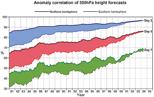
TABLE D.1 Snapshot of Current Data Count of European Centre for Medium-Range Weather Forecasts (ECMWF) Model: Data Ingested and Actually Assimilated
|
|
Data Entering the Screening (percent)a |
Data Assimilated (percent)b |
||
|
Synop |
190,370 |
(0.27) |
38,112 |
(1.06) |
|
Aircraft |
233,306 |
(0.33) |
146,749 |
(4.07) |
|
Satob |
543,340 |
(0.78) |
71,220 |
(1.97) |
|
Dribu |
15,081 |
(0.02) |
4,381 |
(0.12) |
|
Temp |
110,998 |
(0.16) |
63,763 |
(1.77) |
|
Pilot |
98,364 |
(0.14) |
56,324 |
(1.56) |
|
UpperSat |
68,358,565 |
(97.97) |
3,107200 |
(86.19) |
|
PAOB |
530 |
(0.00) |
185 |
(0.00) |
|
Scat |
222,410 |
(0.32) |
117,196 |
(3.25) |
|
Total |
69,772,964 |
|
3,605,130 |
|
|
NOTES: Synop, traditional synoptic weather observations; Aircraft, measurements from aircraft; Satob, satellite observations; Dribu, drift buoys; Temp, temperature measurements other than synoptic; Pilot, commercial aviation observations; UpperSat, upper atmospheric measurements; PAOB, synthetic surface pressure data; Scat, scatterometer. aOf screened data, 99.07 percent are satellite data. bOf assimilated data, 91.41 percent are satellite data. SOURCE: ECMWF. |
||||
There is now a stronger dependence on satellite data in the ECMWF system, and the influence of other, nonsatellite data types is becoming less important.
ECMWF’s success as a satellite data user is evidenced by the fact that more than 99 percent of the data ingested by its NWP models is from meteorological and environmental satellites, and more than 91 percent of its model-assimilated data is satellite data (Table D.1).
Summary
The case study summary presented here5 emphasizes ECMWF’s ability to deal with the end-to-end aspect of the satellite data utilization in the NWP centers. The agency considers that each chain in the link is equally important and that they all matter:
-
ECMWF has a talented, flexible, and agile operations department that is eager to deliver new data, both from operational satellites and from research satellites, to
-
the research department and then to implement the new data quickly into operations when the research and validation are mature.
-
ECMWF has an equally capable research team of satellite, assimilation, modeling, and computer specialists who work closely and interactively and to the highest scientific standards to exploit new observational technologies that improve the ECMWF analyses, model, and forecasts.
-
ECMWF has a powerful, flexible, theoretically well founded, and highly efficient four-dimensional variational data assimilation system, which was designed to use a wide range of nadir-scanning or conically scanning satellite data as well as all in situ data. The assimilation system is being extended to cope comfortably with new viewing geometries such as GPS and limb-sounding data.
-
ECMWF has powerful computers and data-handling systems.
-
ECMWF has a powerful data-monitoring capability in its operational and research assimilation systems, which compare engineering-calibrated, geolocated satellite measurements (measured radiances, scatterometer radar cross sections, and so on) with the model equivalent of the measurement. This is a powerful means of identifying anomalies in the measurements (and in the model). The data-monitoring results are an important element in ECMWF’s active dialogue with all of its data providers, including NESDIS and NASA.
-
ECMWF has strong support from EUMETSAT, ESA, and the EU in the form of fellowships and research contracts that fund postdoctoral research associates for work on satellite assimilation.
-
ECMWF has strong support for its satellite work from its governing body, representing 18 European governments.
In summary, ECMWF has demonstrated that both operational and research satellite data are more important than nonsatellite data, are crucial for the success of weather forecasting, and can be optimally utilized from reception to end use. ECMWF relies on its visionary leadership, seamless partnerships, efficient administration, well-funded infrastructure, and expert teaming; on its intelligent data-monitoring, modeling, and processing system; and, most of all, on its willingness to take on challenges of finding ways to incorporate emerging satellite measurements to improve its mission objectives. And finally, “We [at ECMWF] must constantly make the case for the necessary resources (computing, personnel) to exploit the huge investments in satellite data.”6
THE BILKO PROJECT: A CASE STUDY IN EDUCATING USERS
To facilitate and improve the use of environmental satellite data, education and/ or training are needed to help users effectively address the following key issues:
-
What environmental parameters are measured by satellite?
-
For a desired parameter, how can data availability be determined?
-
For those data, what are the coverage, sampling, and data storage characteristics?
-
How can the data be obtained, from whom, in what form, at what cost, and with what delay?
-
How can the data be worked with to produce desired products and information?
-
What are the quality and accuracy issues with the data, and where are the techniques and associated calibration procedures summarized?
For the user seeking to learn generally what parameters are measured by satellites or to find out if a specific parameter is available, locating a comprehensive directory of satellite data is a challenge. Once the user learns, for example, that ocean surface temperature is measured by instruments onboard satellites, the next challenge is to determine whether the observations can be obtained, over what time and over what part of Earth there is coverage, whether the region and time of interest are included in the available data, and whether the time/space resolution of the data meets the user’s needs. If there is coverage, the user must then determine how to obtain the data and then learn how to work with them: Are they image or digital files? How are the files to be manipulated? Have the data been geolocated and converted to engineering units? Is further calibration needed? Once work with the data begins and a path toward products or desired information is being followed, some users need to know more about how the measurements were made and about the accuracies and uncertainties of the data so that these characteristics can be reflected in the final products.
All of these problems—including the lack of centralized information about what satellite data are available and how they can be obtained, and the fact that working with the large data files is daunting for many, especially if the data need to be geolocated and processed to obtain useful fields—constitute impediments to the use of environmental satellite data. To deal with these challenges, a number of efforts have been made to provide education and hands-on training at various satellite data centers nationally and internationally. The Bilko project is such an effort within the oceanographic community. It is sponsored by the United Nations Educational,
Scientific, and Cultural Organization (UNESCO) with the goal of providing a “virtual global faculty for ocean and coastal remote sensing.”7
The Bilko Web site8 provides DOS and Windows software modules for a series of lessons. These lessons provide satellite imagery and take the user through the steps associated with using the images to address scientific questions. The images, the processing software, a tutorial in the use of the software, and lessons on oceanographic and coastal management applications of the software are provided in each module. The book developed to accompany the software is entitled UNESCO Bilko Resource Book: An Index to Computer Based Learning Modules in Remote Sensing of Coastal-Marine Environment.9
The Bilko software modules are quite extensive, each containing a number of exercises. The modules focus on various topics, including geographical areas (Atlantic, Pacific, Indian Oceans); thematic areas (coastal management, open ocean); data types (optical and infrared, microwave, airborne and in situ, numerical modeling); sea-surface temperature; ocean fronts; color scanner data; joint analysis of AVHRR and color scanner data; marginal seas; synthetic aperture radar data; seasonal variation of phytoplankton; coastal discharges; upwelling; coastal plumes and coastal management; sea ice; global winds; ocean eddies; bio-optical variability; coastal upwelling; dependence of AVHRR sea-surface temperature on satellite zenith angle; bathymetry; coastal ecosystems; red tides; coastal vegetation; acquiring images with appropriate scales and resolution; radiometric corrections; and marine vegetation.
DIRECT BROADCAST
The NOAA POES and GOES and NASA EOS satellites all currently provide direct-broadcast capability—direct broadcast here meaning that data acquired by satellite sensors are broadcast in real time to any ground station within range of the satellite’s current position. The data are unencrypted and the signal characteristics are published, so the data are immediately accessible to any organization or individual with the wherewithal to deploy and operate a ground station. The cost of doing so is primarily a function of the broadcast signal strength (a weaker signal requires a larger antenna) and frequency (a higher frequency supports a higher data bandwidth but requires more expensive signal processing hardware). Polar-orbiting satellites (POES and EOS) additionally require an antenna that can be steered to track the satellite during data acquisition.
|
7 |
Available online at http://www.unesco.bilko.org. Accessed June 24, 2004. |
|
8 |
Available online at http://www.ncl.ac.uk/tcmweb/bilko/intro.shtml. Accessed June 24, 2004. |
|
9 |
Available online at http://www.ncl.ac.uk/tcmweb/bilko/bilko_resource_book.doc. Accessed June 24, 2004. |
There are two principal rationales for direct broadcast. First, making the data publicly available in real time allows alternate processing chains to be independently developed and supported, adding considerable robustness to the overall system. Second, and more significant, because direct broadcast operates on a line of sight between the satellite and the ground station (as opposed to the playback of a signal recorded when the satellite is not visible), ground stations generally acquire local and/or regional data, which they may then customize for local and/or regional applications. Direct broadcast thus puts the data that much closer to the application.
A specific example is illustrative: Since 1994, the Institute for Computational Earth System Science (ICESS) at the University of California, Santa Barbara (UCSB) has operated an L-band ground station provided by the SeaSpace Corporation (one of several commercial vendors of ground station technology). A 1.2-m dish antenna mounted atop a six-story office building automatically tracks (using continuously updated orbit models) all currently operating NOAA satellites whenever they are above the horizon (Figure D.2(a)). An L-band receiver detects the high-resolution picture transmission signal from the AVHRR sensor. Analog data from the receiver are passed to a dedicated workstation, which decodes the multichannel digital image and initiates a standard processing sequence: reflectance/temperature retrieval, navigation to geographic coordinates, extraction of local and regional subsets, and archiving. Aside from the antenna, the entire system (antenna controller, receiver, workstation, and multiterabyte online archive) fits easily in the corner of an office (Figure D.2(b)). In 1993 the system cost approximately $50,000; today it would cost less than half that to replace it.
The ICESS ground station has been used to support both oceanic and terrestrial applications. In addition to contributing to research on long-term ocean processes in the Southern California Bight, the ground station’s 10-year time series of consistently calculated sea-surface temperature has been exploited by local fishermen, even at the relatively crude resolutions available in false-color images delivered through a Web browser (see Plate 6). The availability of a similarly long-term data set of surface reflectance has been invaluable in operationalizing snow-covered-area algorithms developed by UCSB researchers (see Plate 7). Accumulating detailed time series over specific areas of interest, while at the same time accommodating real-time data needs (short-lived phenomena, field campaigns, and so on) would have been vastly more difficult, if not impossible, without a dedicated ground station.
Direct-broadcast processing software that can convert satellite signals to calibrated physical units and products is also provided by government-university collaborative efforts. For example, the International MODIS (Moderate-resolution Imaging Spectroradiometer) and AIRS (Atmospheric Infrared Radiation Sounder)
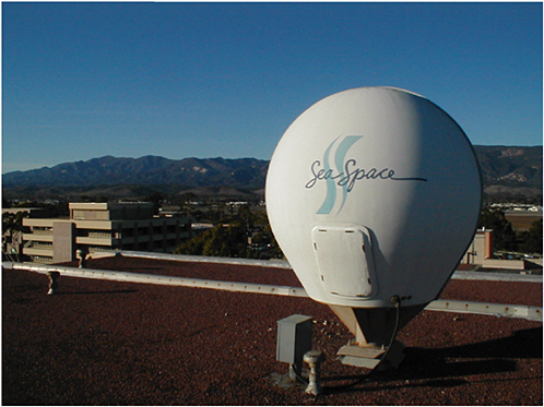
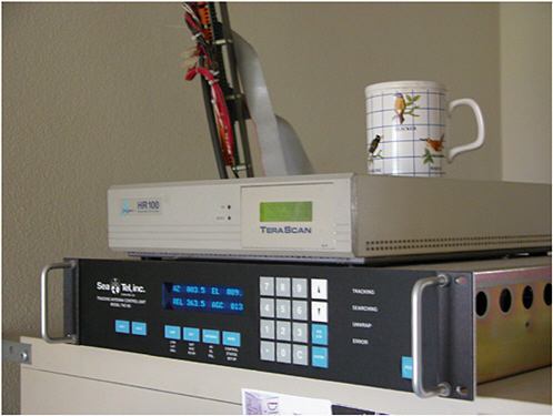
FIGURE D.2 (top) Dish antenna of the high-resolution picture transmission (HRPT) ground station operated by the Institute for Computational Earth System Science (ICESS), University of California, Santa Barbara. (bottom) The HRPT ground station electronics (top unit, receiver; bottom unit, antenna controller, coffee mug for scale. Photos courtesy of the ICESS, University of California, Santa Barbara.
TABLE D.2 Summary of Algorithms for Current and Upcoming International MODIS (Moderate-resolution Imaging Spectroradiometer) and AIRS (Atmospheric Infrared Radiation Sounder) Processing Package (IMAPP) Products
Processing Package (IMAPP)10 is a NASA-funded, freely distributed software package that allows any ground station capable of receiving direct broadcast from Terra or Aqua satellites to produce calibrated and geolocated radiances and a variety of environmental products.
IMAPP’s capabilities, beyond providing rigorous sensor measurement calibration and geolocation, are summarized in Table D.2. These products range from atmospheric properties of clouds, sounding profiles, and precipitation, to surface properties of surface temperature, reflectance, and types. All of these products are designed to be available for direct broadcast in near real time (within 2 hours of data reception). Most important, the processing algorithms of IMAPP are validated to achieve the same quality as that of the official products produced by government-university teams.
The IMAPP software11 has been ported to a variety of UNIX and personal computer platforms. The software has been well received by a wide variety of users
|
10 |
H-L. Huang, L.E. Gumley, K. Strabala, J. Li, E. Weisz, T. Rink, K.C. Baggett, J.E. Davies, W.L. Smith, and J.C. Dodge, 2004, “International MODIS and AIRS Processing Package (IMAPP)—A Direct Broadcast Software Package for the NASA Earth Observing System,” Bulletin of the American Meteorological Society 85(2):159-161. |
|
11 |
Available online at http://cimss.ssec.wisc.edu/~gumley/IMAPP/. Accessed June 18, 2004. |
and is currently in use at more than 75 ground stations around the world. IMAPP is also supplied as a standard feature by many commercial ground station vendors.
THE ADVANCED VERY HIGH RESOLUTION RADIOMETER (AVHRR) NORMALIZED DIFFERENCE VEGETATION INDEX (NDVI) PATHFINDER
Forward processing of the AVHRR sensor and producing the Normalized Difference Vegetation Index (NDVI) has been done by NOAA across five Television Infrared Observation Satellite (TIROS) platforms since 1981. The AVHRR NDVI, called the Pathfinder, is used operationally by many agencies, such as the U.S. Department of Agriculture’s Foreign Agricultural Service, for global vegetation analysis. NOAA and NASA teamed up to reprocess the NDVI record from its inception, eliminating sensor and orbital degradation effects, and cross-walking the time series of five sensors to eliminate radiometric differences. The resulting consistently reprocessed data set has allowed the first clear detection of decadal trends in global biospheric vegetation.12 The recent finding that global terrestrial net primary production has increased 6 percent between the 1982 and 1999 “greening of the biosphere” (Plate 8) was possible only by building a climate data record for NDVI based on the latest theory and algorithms applied to the full historical record.13 The precision of this record, which was necessary to detect the climate trends, could not have been accomplished in an operational forward processing situation.
MODERATE-RESOLUTION IMAGING SPECTRORADIOMETER (MODIS) FIRE RAPID RESPONSE SYSTEM
A primary objective of the NASA Earth Observing System has been to deliver usable remote sensing data products to a wider array of less-sophisticated users. While it is still too soon to assess the overall success of this objective, there have been marked successes and failures during EOS’s years of operation. The failures have been traced initially to technical problems—data being delivered in unfamiliar formats and geographic projections, overly complex user interfaces and ordering procedures, insufficient subsetting so that users were forced to deal with huge data files, poor documentation, and incomplete metadata. These problems have progressively been solved or alleviated, and now the larger test is whether the EOS data can actually provide important information to the user.
The greatest EOS success has come from a user’s identifying a clear data requirement and working directly with an EOS team to customize processing and delivery of the data to user specifications. This success story began shortly after launch of the Terra platform, when the U.S. Forest Service was involved with a summer of major wildfire management, in 2000. Wildfire management is a high-priority land management issue, consuming over $1 billion in costs in active years and with human safety and property risks attracting particular attention to the matter of improving procedures. During a major multiple-event wildfire conflagration in Montana and Idaho in August 2000, the Forest Service approached NASA and the University of Maryland to generate MODIS imagery to evaluate daily fire activity. The initial tests proved that MODIS data were timely, more objective, and cheaper than imagery generated from aircraft, and also that in severe conditions these data may help avoid human safety issues of pilots flying in smoke-obscured mountainous terrain (Plate 9).
During the summers of 2001, 2002, and 2003, the collaboration of NASA, the Forest Service, and the University of Maryland streamlined the direct reception, immediate processing, and distribution of 250 m MODIS data identifying fire activity and perimeters directly to the National Interagency Fire Center in Boise, Idaho, as well as to Regional Fire Coordination Centers. Through a network of fire intelligence specialists, these data were delivered to the incident commanders as part of a daily operational planning and fire assessment cycle (Plate 10 and Figure D.3).
Key to the success of this application has been the continuing interaction among the three partnering groups to identify exactly what remote sensing data are needed in exactly which format, processing the data to meet necessary deadlines, and delivering the data to a particular location for the individual to whom the information is valuable for specific decision making. The utility of MODIS data in broadscale fire assessment has now been well proven. Experiences from the 2003 wildland fire season showed that MODIS is also capable of providing much-needed intelligence at the incident level and that the fire community is able to incorporate satellite data into its daily planning and assessment cycle.
GEOSTATIONARY OPERATIONAL ENVIRONMENTAL SATELLITE (GOES) IMAGER AND SOUNDER
Two satellite orbits provide unique and complementary vantage points for observing the environment: Sun-synchronous and geosynchronous. Sun-synchronous satellites view the entire Earth twice per day (during the day and at night), passing over locations at the same local time every day. Geosynchronous satellites remain at a relatively fixed position, and rather than viewing the entire Earth, instead continuously image one large area of Earth’s disk.
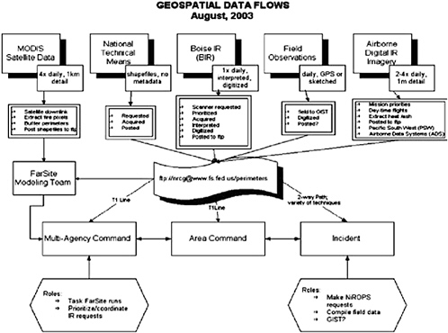
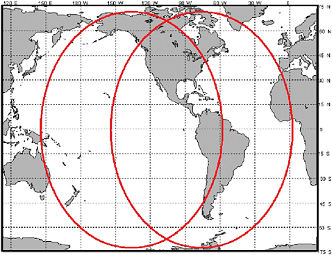
FIGURE D.4 Ground coverage of the Geostationary Operational Environmental Satellite (GOES)-West (left ellipse) and GOES-East (right ellipse) satellites. SOURCE: NASA Goddard Space Flight Center, GOES Hyperspectral Environmental Suite (HES) Performance and Operation Requirements Document (PORD) draft, Volume 0.5.3, September 12, 2003, NASA/GSFC, Greenbelt, Md., Figure 3.2.5, p. 45.
The United States operates two geostationary satellites in geosynchronous orbits, over fixed equatorial positions (Hyperspectral Environmental Satellite [HES] performance and operation requirements document [PORD]; see Figure D.4).14 GOES-East sits at 75°E and best views the central and eastern United States, the Atlantic Ocean (for hurricane season, explosive winter storm developments, and so on), and Central and South America. GOES-West is located at 135°W, best viewing the
|
14 |
Additional information is available online at http://cimss.ssec.wisc.edu/goes/goes.html. Accessed June 18, 2004. |
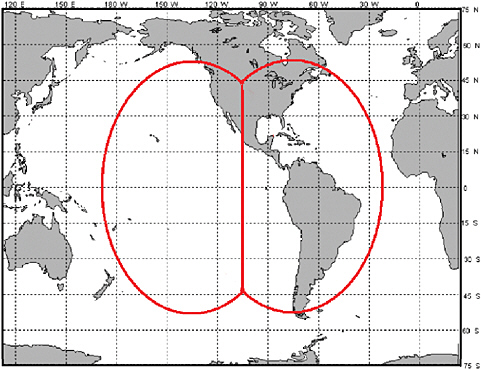
FIGURE D.5 Geostationary Operational Environmental Satellite (GOES)-West and GOES-East integrated coverage. SOURCE: NASA Goddard Space Flight Center, GOES Hyperspectral Environmental Suite (HES) Performance and Operation Requirements Document (PORD) draft, Volume 0.5.3, September 12, 2003, NASA/GSFC, Greenbelt, Md., Figure 3.2.6, p. 46.
United States from the Mississippi River west, and much of the Pacific Ocean (including tropical storms threatening Hawaii and weather systems approaching the Pacific Northwest). The best data are taken with local viewing zenith angles of 62° or less (see Figure D.4). Thus, the two GOES satellites together provide an optimal integrated view of the United States, Central and South America, and weather systems in the neighboring Atlantic and Pacific Oceans (Figure D.5).
The nation’s need for improved geosynchronous observations with higher spectral, temporal, and spatial resolution becomes more critical as environmental data users both in operational areas (e.g., weather forecasters) and in research concen-
trate on improved monitoring and forecasting of rapidly evolving weather processes. NOAA’s strategic goals support the operational needs of the GOES end users, who have demanded improved spatial resolution, spatial coverage, temporal resolution, spectral resolution, and radiometric accuracy. To keep pace with these growing needs, NOAA is continuing to evolve its geostationary environmental remote sensing capability. Satisfaction of significant operational requirements and improvement over today’s systems are directly enabled through technology improvements and research demonstrations, for example, in NASA’s EOS and Ice, Cloud, and land Elevation Satellite (ICESat). To enable NOAA to continue progress in improving its data utilization and forecast services, well-calibrated, well-characterized geosynchronous data must be available for numerical model assimilation and short-term forecasts at National Weather Service field offices. GOES-R sensors will collect significantly higher-quality environmental data and consequently more useful information (GOES-R Mission Requirements Document15). Benefits from the planned GOES-R instruments include the following:
-
Improved understanding of the role of oceans in coupled geophysical and ecological processes,
-
Cost savings and increased safety for marine transportation,
-
Enhanced fisheries production and conservation through science-based knowledge, and
-
Improved numerical-prediction (ocean, atmosphere, and coupled) models.16
For Earth environmental observations, perhaps the three most important sensors to be carried by GOES-R are the Advanced Baseline Imager (ABI), the Hyperspectral Environmental Satellite, and the Geostationary Lightning Mapper (GLM). Additionally, the Geostationary Microwave Imager (GMI), a six-band radiometer (a pre-planned product improvement) will provide time-resolved precipitation imagery and atmospheric vertical temperature and water profiles through cloud cover. In addition to improved sensors, GOES-R is positioned to help solve the greatest deficiencies of today’s system: data latencies ranging from 5 to 40 minutes, several-hour interruptions during the spring and fall solar eclipse seasons, inability to conduct simultaneous global and mesoscale imaging, and degraded image quality owing to direct solar impingement.
|
15 |
“NOAA, 2004. Mission Requirements Document 2A (MRD-2A) for the GOES-R Series, version 2.3, March 23, 2004. Available online at http://www.osd.noaa.gov/goesr_arch_study/docs/MRD2A_03-19-04.pdf. Accessed on June 28, 2004. |
|
16 |
J. Gurka, T. Schmit, and R. Reynolds, 2003, “Highlights from the Second GOES Users’ Conference: Recommendations for the GOES-R Series,” presented to the American Meteorological Society. |
TABLE D.3 GOES Imager Current and Upgraded Capability
ABI is the primary GOES-R cloud, land, and ocean imager. A significant upgrade to the capability of the current GOES imager, ABI is intended to provide enhanced spatial and temporal resolution and spectral capability to meet data product requirements described in the mission requirements document for atmospheric, oceanic, and land environmental sensing. These requirements include severe weather, fog, and nighttime low-cloud monitoring, volcanic cloud detection, microphysical cloud properties retrieval, thin cirrus detection, improved measurement of sea-surface temperatures, and observations of surface properties.17 As illustrated in Table D.3, ABI will take full-disk images every 5 minutes, five times more rapidly than today’s geosynchronous imagers, with the capability of monitoring severe weather events in 1,000 x 1,000 km boxes with 30-second reimaging (refresh).
As illustrated in Table D.4, HES will retrieve atmospheric vertical temperature (T) and water vapor (q) profiles, including hourly full-disk sounding, severe weather/ mesoscale tasking with 2- to 4-minute refresh, and coastal waters (CW) imaging.18 The principal HES improvement over today’s GOES sounder is in its spectral separation performance. Instead of 19 discrete channels in the current sounder, HES will
|
17 |
T. Schmit and P. Menzel, 1999, “Spectral Band Selection for the Advanced Baseline Imager (ABI).” Available online at http://cimss.ssec.wisc.edu/goes/abi/ppt/abi_R&D.ppt. Accessed on June 24, 2004. |
|
18 |
HES Performance Operational Requirements Document. Available online at http://goes2.gsfc.nasa.gov/HEShome.htm. Accessed on June 24, 2004. |
TABLE D.4 GOES Sounder Current and Upgraded Capability
sense from 1,700 to 3,400 narrow channels using either dispersive (demonstrated by the AIRS instrument) or Fourier transform (demonstrated by aircraft instruments and the NPOESS Cross-track Infrared Sounder) spectroscopy. HES will also enable the four-dimensional profiling of winds (“V”). This increase in collected environmental data will yield a corresponding improvement in environmental information, enabling reductions in retrieval uncertainty while simultaneously improving the vertical resolution—for example, temperature inversions will be detectable.
Based in part on the success of the Tropical Rainfall Measuring Mission (TRMM) Lightning Imaging Sensor, the GLM will continuously map all forms of continental United States lightning discharges and measure total lightning activity over large areas of the Americas and nearby oceans on a continuous basis. GLM will help advance tornado warnings by 20 minutes, while enhancing lightning and intensity hazard alerts.


