National Academies Press: OpenBook
« Previous: Executive Summary
Suggested Citation:"1 Introduction." National Research Council. 2006. Assessment of the Benefits of Extending the Tropical Rainfall Measuring Mission: A Perspective from the Research and Operations Communities: Interim Report. Washington, DC: The National Academies Press. doi: 10.17226/11195.
×

1
Introduction

SCOPE OF THE REPORT

This is the interim report of the Committee on the Future of the Tropical Rainfall Measuring Mission (TRMM) (see Appendix A). The charge to the committee in this first phase of its work is to conduct a workshop and prepare an interim report to be delivered in December 2004 on how best to use the remaining TRMM spacecraft life. In particular, the committee and workshop participants were asked to consider:

  • scientific and research contributions of TRMM to date and those expected if TRMM is continued;

  • operational contributions of TRMM to date and those expected if TRMM is continued;

  • assessment of expected benefits of continuing TRMM operation until (1) fuel is depleted to the level needed for a controlled reentry (around December 2005) and (2) all fuel is depleted (estimated to be 2010-2011).

A later phase of the committee’s work will focus on needs for satellite-based measurements of tropical rainfall beyond TRMM (see Appendix B).

The decision context for mission extension has three major components: the operational and research benefits of extension, financial constraints, and risk to life and property during satellite reentry. In December 2004 the National Aeronatuics and Space Administration (NASA) will weigh the research and operational benefits against the cost of extending the mission for approximately one year. If NASA decides to continue TRMM, a second decision point will be

Suggested Citation:"1 Introduction." National Research Council. 2006. Assessment of the Benefits of Extending the Tropical Rainfall Measuring Mission: A Perspective from the Research and Operations Communities: Interim Report. Washington, DC: The National Academies Press. doi: 10.17226/11195.
×

forced in approximately December 2005. At that point the agency will have to weigh the societal benefits of TRMM against both the additional cost and the risk of an uncontrolled reentry if the remaining fuel is used to maintain the satellite’s orbit rather than to guide the spacecraft into the ocean.

The committee’s task focused on the research and operational benefits component of the decision. The committee was not tasked to analyze the risk or cost components, although these components are part of the overall context and thus laid out in Chapter 2. Chapter 3 describes the achievements of TRMM in research and operations to date and Chapter 4 looks to the potential future research and operational applications of TRMM. Chapter 4 differentiates between the potential contributions from a TRMM extension until fuel is depleted to a level that is still sufficient for a controlled reentry or until all fuel is depleted. A series of appendixes provides supporting information that is referenced in the body of the report.

AUDIENCE FOR THE REPORT

The audience for this report includes NASA and the Japan Aerospace Exploration Agency (JAXA), operational agencies (e.g., the National Oceanic and Atmospheric Administration [NOAA], Department of Defense agencies), Congress (e.g., House Science Committee), the White House Office of Science and Technology Policy and Office of Management and Budget, the scientific community in general, and users in particular.

INFORMATION GATHERING AND WORKSHOP DIMENSIONS

The committee gathered information using four approaches.

  1. inviting presentations at a workshop on November 8, 2004 (see Appendix C);

  2. promoting and tracking discussion at the workshop (from participants in the room and on the phone [see Appendix D]);

  3. reviewing existing written materials, such as peer-reviewed papers, reports, information from Websites, and letters; and

  4. soliciting input to a Website that posed questions relating to the committee’s phase I task.

The workshop had four sessions (Appendix C) with formal input from 14 people. Approximately 45 people attended the workshop and participated in general discussion. Participants from Japan attended on an open phone line. The formal presentations are available on the Web.1

Suggested Citation:"1 Introduction." National Research Council. 2006. Assessment of the Benefits of Extending the Tropical Rainfall Measuring Mission: A Perspective from the Research and Operations Communities: Interim Report. Washington, DC: The National Academies Press. doi: 10.17226/11195.
×

HISTORY OF THE TROPICAL RAINFALL MEASURING MISSION

The TRMM was motivated by recognition of the fundamental importance of precipitation in Earth’s climate system, the inadequate network of surface precipitation measurements over much of Earth, and recognition of the crucial role of tropical rainfall in global climate dynamics and the global hydrologic cycle.

The TRMM science plan was developed in the late 1980s (Simpson et al., 1988). The overarching mission science goal was to advance knowledge of global water and energy cycles by observing from space the temporal and spatial distribution of tropical rainfall and associated latent heating. TRMM thus carried a suite of five sensors (Box 1-1 and Figure 1-1) designed to address seven key science questions (Box 1-2).

TRMM was launched in November 1997 as a joint effort of NASA and JAXA. It has a low-inclination, precessing orbit between 35°north and 35°south. The mission was designed as a science path-finding experiment that would last a minimum of three years with an initial goal of five years. Based on TRMM’s excellent performance and promise, NASA and JAXA decided in 2001 to extend the mission. TRMM’s orbit was boosted from 350 km to 402.5 km to reduce drag and conserve fuel.

TRMM has now been operating successfully for seven years. Initially the TRMM data were provided to users in a delayed mode because of the mission’s original focus on research. Since the data became available in near real time in Fall 1998, they have been increasingly used in operational applications, especially for monitoring and predicting tropical cyclones.

As a consequence of TRMM’s success the research and operational communities have created a demand for the continuation of TRMM data (see, for example, Appendixes E through H). To date, however, no party outside NASA has stepped forward to contribute to the cost of continued TRMM operations. Although NASA and JAXA agreed to decommission TRMM in July 2004, TRMM is being kept alive through 2004 because of pressure from the research and operational community that ultimately led to a direct request from the NOAA administrator to the NASA administrator (Appendix H and I).

GLOBAL PRECIPITATION MEASUREMENT MISSION

Since 2001, NASA, JAXA, and other international partners have been planning the Global Precipitation Measurement (GPM) mission, a follow-up on TRMM to measure precipitation on a global scale (NASA, 2004). GPM is envisioned as a constellation of approximately eight satellites, with a core satellite similar to TRMM. All of these satellites will carry passive microwave sensors for rainfall estimation. Key sensors onboard the core spacecraft will be a dual-frequency precipitation radar and a multichannel microwave imager. GPM goes beyond TRMM in several important ways: The number of satellites in the con-

Suggested Citation:"1 Introduction." National Research Council. 2006. Assessment of the Benefits of Extending the Tropical Rainfall Measuring Mission: A Perspective from the Research and Operations Communities: Interim Report. Washington, DC: The National Academies Press. doi: 10.17226/11195.
×

BOX 1-1

Instruments Onboard TRMM

The TRMM observational system described in the 1988 science plan (Simpson, 1988) consisted of three instruments: a Precipitation Radar (PR), a Microwave Imager (TMI), and a Visible and Infrared Scanner (VIRS). Two additional sensors were added before the November 1997 launch: a Lightning Imaging Sensor (LIS) and a Clouds and Earth Radiant Energy System (CERES) instrument.

  • PR is the key TRMM instrument. It was the first and continues to be the only spaceborne weather radar. It provides three-dimensional profiles of storm structure as well as intensity and vertical and horizontal distribution of precipitation and precipitation type.

  • TMI is a multichannel, dual-polarized, conically scanning passive microwave instrument designed to provide quantitative estimates of rainfall, water vapor, cloud water content, and sea surface temperature by measuring the minute amounts of microwave energy emitted from Earth and its atmosphere.

  • VIRS provides a very indirect observation of rainfall. It senses radiation emitted from Earth in five spectral regions ranging from visible to infrared.

  • LIS detects lightning, even in the presence of bright clouds. This sensor can “stare” at the same point for up to 80 seconds, enabling it to determine lightning rates.

  • CERES measured the energy levels at the top of the atmosphere and could provide estimated energy levels within the atmosphere and at Earth’s surface. This instrument failed about eight months after launch.

The combination of instruments onboard TRMM provides a unique resource for cross-calibration with other remotely sensed precipitation estimates. The TRMM satellite radar and radiometer combination—PR, TMI, and VIRS—was designed to obtain high-quality vertical precipitation profiles as well as surface rainfall estimates. TRMM’s rainfall-rate observations from the combined radar and passive microwave instruments—PR and TMI—calibrate the empirical rain estimates from the visible and infrared radiometer. VIRS therefore allows comparison with and calibration of the National Polar-Orbiting Operational Environmental Satellite System and Geostationary Operational Environmental Satellites.

Kummerow et al. (2000) provide more detail on the TRMM instruments, algorithms, and a wide range of early results.

Suggested Citation:"1 Introduction." National Research Council. 2006. Assessment of the Benefits of Extending the Tropical Rainfall Measuring Mission: A Perspective from the Research and Operations Communities: Interim Report. Washington, DC: The National Academies Press. doi: 10.17226/11195.
×

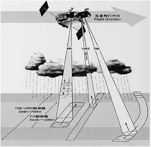
FIGURE 1-1 Schematic illustration of the TRMM satellite sensors and how they collect data. SOURCE: Presentation by Jack Kaye, NASA, at November 8, 2004, workshop.

stellation will facilitate a significant reduction in revisiting time (a three-hour sampling interval is anticipated) over TRMM, the core satellite will cover a broader latitudinal band (up to approximately 50 degrees), and the dual-frequency precipitation radar will assist in reducing uncertainty due to raindrop size variability and also measure lighter precipitation than TRMM. The GPM launch is currently projected for 2010 at the earliest.2

2

As stated by Mary Cleave, NASA, at the committee’s November 8, 2004, workshop. For up-to-date GPM information, visit the mission Website at http://gpm.gsfc.nasa.gov.

Suggested Citation:"1 Introduction." National Research Council. 2006. Assessment of the Benefits of Extending the Tropical Rainfall Measuring Mission: A Perspective from the Research and Operations Communities: Interim Report. Washington, DC: The National Academies Press. doi: 10.17226/11195.
×

BOX 1-2

The Original Seven Priority Science Questions to be Addressed by TRMM

  1. What is the four-dimensional structure of latent heating in the tropical atmosphere? How does it vary diurnally, intraseasonally, seasonally, and annually?

  2. What is the role of latent heat released in the tropics in both tropical and extratropical circulation?

  3. What is the monthly average rainfall over tropical ocean areas of about 105 km2 and how does this rain and its variability affect the structure and circulation of the tropical oceans?

  4. What is the relationship between precipitation and changes in boundary conditions at Earth’s surface (e.g., sea surface temperature, soil properties, vegetation)?

  5. What is the diurnal cycle of tropical rainfall and how does it vary in space?

  6. What are the relative contributions of convective and stratiform precipitation and how does it vary in space?

  7. How can improved documentation of rainfall improve understanding of the hydrological cycle in the tropics?

Suggested Citation:"1 Introduction." National Research Council. 2006. Assessment of the Benefits of Extending the Tropical Rainfall Measuring Mission: A Perspective from the Research and Operations Communities: Interim Report. Washington, DC: The National Academies Press. doi: 10.17226/11195.
×
Page 11
Suggested Citation:"1 Introduction." National Research Council. 2006. Assessment of the Benefits of Extending the Tropical Rainfall Measuring Mission: A Perspective from the Research and Operations Communities: Interim Report. Washington, DC: The National Academies Press. doi: 10.17226/11195.
×
Page 12
Suggested Citation:"1 Introduction." National Research Council. 2006. Assessment of the Benefits of Extending the Tropical Rainfall Measuring Mission: A Perspective from the Research and Operations Communities: Interim Report. Washington, DC: The National Academies Press. doi: 10.17226/11195.
×
Page 13
Suggested Citation:"1 Introduction." National Research Council. 2006. Assessment of the Benefits of Extending the Tropical Rainfall Measuring Mission: A Perspective from the Research and Operations Communities: Interim Report. Washington, DC: The National Academies Press. doi: 10.17226/11195.
×
Page 14
Suggested Citation:"1 Introduction." National Research Council. 2006. Assessment of the Benefits of Extending the Tropical Rainfall Measuring Mission: A Perspective from the Research and Operations Communities: Interim Report. Washington, DC: The National Academies Press. doi: 10.17226/11195.
×
Page 15
Suggested Citation:"1 Introduction." National Research Council. 2006. Assessment of the Benefits of Extending the Tropical Rainfall Measuring Mission: A Perspective from the Research and Operations Communities: Interim Report. Washington, DC: The National Academies Press. doi: 10.17226/11195.
×
Page 16
Next: 2 Decision Context »
Assessment of the Benefits of Extending the Tropical Rainfall Measuring Mission: A Perspective from the Research and Operations Communities: Interim Report Get This Book
×
 Assessment of the Benefits of Extending the Tropical Rainfall Measuring Mission: A Perspective from the Research and Operations Communities: Interim Report
Buy Paperback | $41.00 Buy Ebook | $32.99
MyNAP members save 10% online.
Login or Register to save!
Download Free PDF

Launched jointly in 1997 by the National Aeronautics and Space Administration (NASA) and the Japan Aerospace Exploration Agency (JAXA), the Tropical Rainfall Measuring Mission (TRMM) is a satellite mission that placed a unique suite of instruments, including the first precipitation radar, in space. These instruments are used to monitor and predict tropical cyclone tracks and intensity, estimate rainfall, and monitor climate variability (precipitation and sea surface temperature). TRMM has been collecting data for seven years; this data is used by the Joint Typhoon Warning Center, the National Center for Environmental Prediction, and the National Hurricane Center, among others worldwide. In July 2004, NASA announced that it would terminate TRMM in August 2004. At the request of the National Oceanic and Atmospheric Administration (NOAA), the White House, and the science community, NASA agreed to continue TRMM operations through the end of 2004. Meanwhile, NASA asked a National Research Council (NRC) committee to provide advice on the benefits of keeping TRMM in operation beyond 2004. After holding a workshop with a number of experts in the field, the committee found that TRMM will contribute significantly to operations and science if the mission is extended; and therefore, strongly recommends continued operation of TRMM with the caveat that cost and risk will need to be further examined before a final decision about the future of TRMM can be made.

READ FREE ONLINE

  1. ×

    Welcome to OpenBook!

    You're looking at OpenBook, NAP.edu's online reading room since 1999. Based on feedback from you, our users, we've made some improvements that make it easier than ever to read thousands of publications on our website.

    Do you want to take a quick tour of the OpenBook's features?

    No Thanks Take a Tour »
  2. ×

    Show this book's table of contents, where you can jump to any chapter by name.

    « Back Next »
  3. ×

    ...or use these buttons to go back to the previous chapter or skip to the next one.

    « Back Next »
  4. ×

    Jump up to the previous page or down to the next one. Also, you can type in a page number and press Enter to go directly to that page in the book.

    « Back Next »
  5. ×

    Switch between the Original Pages, where you can read the report as it appeared in print, and Text Pages for the web version, where you can highlight and search the text.

    « Back Next »
  6. ×

    To search the entire text of this book, type in your search term here and press Enter.

    « Back Next »
  7. ×

    Share a link to this book page on your preferred social network or via email.

    « Back Next »
  8. ×

    View our suggested citation for this chapter.

    « Back Next »
  9. ×

    Ready to take your reading offline? Click here to buy this book in print or download it as a free PDF, if available.

    « Back Next »
Stay Connected!