
3
Achievements of TRMM to Date
INTRODUCTION
The National Aeronautics and Space Administration (NASA) and the Japan Aerospace Exploration Agency (JAXA) developed the Tropical Rainfall Measuring Mission (TRMM) primarily to demonstrate the utility of space-based radar and passive microwave sensors for measuring precipitation and associated hydrological processes. This aspect of TRMM has succeeded beyond expectation. Other than the Clouds and Earth Radiant Energy System (CERES) instrument, which failed eight months after launch of the satellite, the systems have operated flawlessly for seven years, during which time they have produced large amounts of research-quality data and value-added real-time operational support. As a result, uncertainty in space-based measurement of tropical rainfall has been greatly reduced from earlier estimates.
As this chapter will demonstrate, the science priority questions in the original TRMM science plan (see Box 1-2) have largely been addressed. The insights gained from TRMM so far and the wealth of information that continues to be provided by TRMM has enabled the science community to further advance its objectives in trying to understand the nature of tropical hydrometeorology and climate. Perhaps the success of this mission is best reflected in the decision to pursue the follow-on Global Precipitation Measurement (GPM) initiative.
This chapter summarizes the effect of TRMM on science and operations, highlights the many unique attributes of TRMM that make the mission valuable to science and operations, examines the longevity and current state of its instruments, and presents a broad summary of the research and operational achievements of TRMM to date.
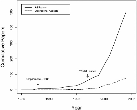
FIGURE 3-1 Evidence of a rapidly growing body of refereed publications directly related to TRMM. The data are obtained by searching the Institute for Scientific Information’s Science Citation Index for papers that mention TRMM either in the title, abstract, or keywords. Papers dealing with operational aspects are based on terms such as “real-time,” “operational,” and “assimilation.” SOURCE: Matthias Steiner, Princeton University.
EFFECT OF TRMM
One proxy measure of TRMM’s effect on the scientific enterprise and technology development is the dramatically increasing number of refereed publications that mention TRMM (see Figure 3-1).1 The TRMM launch triggered a flood of research that led to significant improvements in our understanding of tropical weather systems and their prediction, as well as quantification of key
aspects of the hydrologic cycle and the climate system. The studies captured in Figure 3-1 span a broad spectrum of topics. They include contributions to increasing the basic scientific knowledge needed for future applications (e.g., descriptive and diagnostic studies) as well as operational applications (e.g., monitoring weather features, notably tropical cyclone activity, climate monitoring, numerical weather prediction and climate model development, and model assimilation of TRMM data in forecast operations). Operational applications of the emerging knowledge lag behind research applications (see Figure 3-1); however, operational use of the TRMM data has substantially increased as quality control issues have been resolved. Routine generation of TRMM data products started in 1998. Today TRMM data products can be accessed in real time on the Internet (Hawkins et al., 2001).
UNIQUENESS OF TRMM
TRMM has two unique attributes that make it ideal for observing tropical rainfall systems: (1) its suite of complementary observing instruments and (2) its orbital characteristics. In later sections of this and the next chapter, we differentiate between applications that use TRMM data only, or as the primary component of a research or operational activity (single asterisk), and those that use TRMM data as a complementary component of an operational or research activity (marked with a double asterisk).2
Uniqueness of TRMM Sensors
TRMM provides a complementary suite of active and passive sensors flown on a single platform providing a unique view of precipitation. Due to its complement of instruments, TRMM has been called a “flying rain gauge.” The TRMM observing system employs the only precipitation weather radar in space (referred to as the Precipitation Radar, or PR). The PR provides the most direct method of observation of precipitation and its vertical distribution (i.e., enabling a three-dimensional view of precipitation). Efforts to resolve disagreements between precipitation estimates from the PR and TRMM Microwave Imager (TMI) are only now reaching the point where TRMM’s potential to act as a global rainfall reference standard may be utilized. Without the PR in space, there will be no similar opportunity for calibration with an active sensor until the GPM core satellite is launched.
|
BOX 3-1 Using TRMM Data as a Global Reference for Precipitation Estimates Use of TRMM data as the global reference against which data from space-borne microwave sensorsa are adjusted is the subject of ongoing research (Berg, 2004; Joyce et al., 2004; Ushio et al., 2004). The combination of TRMM’s unique sensor suite and orbit underpins this approach. In this approach, data from microwave sensors are compared with the TRMM PR or TMI data over 10- to 30-day intervals rather than for individual overpasses because of inherent fluctuations and differences at the single-overpass timescale. For added detail, the 10- to 30-day datasets are divided into latitude bins (e.g., 0 to 10 degrees, 10 to 20 degrees, etc.) and time bins (e.g., local midnight to 0300, local 0300 to 0600, etc.). TRMM is the only satellite that collects precipitation data across all local times and can therefore populate all time bins. By comparison, SSM/I data can populate all 10-degree boxes but only at fixed local times. If AMSR-E were the reference instead of TRMM there would be no intersecting time boxes between SSM/I (channel F-15, for example) and AMSR-E because AMSR-E views at 1330 and 0130 local time and SSM/I views at 1030 and 2230 local time.
|
TRMM’s Unique Orbit
TRMM’s unique orbital characteristics enable it to fill temporal and spatial sampling gaps from all current and soon-to-be-launched weather-related satellite sensors (see Box 3-1). TRMM’s 35-degree inclination, low altitude (402.5 km), and non-sunsynchronous3 orbit provides multiple benefits when compared with the space and time sampling dictated by standard polar orbiting environmental satellite trajectories. The low-latitude orbit permits rapid updating in the tropical belt and the precessing nature of the orbit allows for sampling of the diurnal variation of precipitation. The ability to map and monitor rain at nonstandard viewing times (relative to the polar-orbiting satellites) permits a better understanding of rain event life cycles when combining TRMM data with visible, infrared, and passive microwave sensors on other satellites.
LONGEVITY AND STATUS OF TRMM SENSORS AND SPACECRAFT
Apart from the CERES sensor that failed after eight months, there are presently no indications of instrument, platform, or bus degradation; the TRMM
satellite and its PR, TMI, Visibile and Infrared Scanner (VIRS), and Lightning Imaging Sensor (LIS) sensors remain in excellent shape.4 NASA Goddard Space Flight Center (GSFC) conducted an independent assessment of the TRMM spacecraft and instruments. GSFC studied the wear-out mechanisms and concluded that the probability of TRMM’s life limited by various failure mechanisms such as radiation, atomic oxygen, or gyro failures through 2010 is “very low.”5 In a separate analysis of the PR, there was no indication that it is likely to fail in the near future.6
The reliability of the TRMM PR has not only demonstrated the feasibility of operating such technology in space but it has also demonstrated the potential of this technology for future operational systems.
The TMI, VIRS, and LIS sensors can fully operate at any altitude prior to a deorbit burn as long as the solar array is configured to provide sufficient sensor power.7 The PR can only provide partial data during the descent if power is available because the sensor’s attributes dictate specific altitude windows in which full data fidelity is possible. The PR’s pulse repetition frequency and its need to fully sample the atmospheric column from the Earth’s surface to approximately 18 km altitude create windows at approximately 50-km intervals in which the PR achieves full capability.8 Thus, the original 350-km orbit and the current 402.5-km orbit are PR-optimized. The spacecraft can drift slightly up or down from these baseline altitudes and fully retrieve atmospheric rain profiles. However, when TRMM was permitted to go below 395 km during the summer of 2004, the sensor started to miss the highest rain tops near 18 km.9
CONTRIBUTIONS OF TRMM TO RESEARCH
The contributions of TRMM are divided into two categories: (1) climate and weather and (2) applied research that increases the knowledge base to enhance applications.
Climate and Weather
Many of the key TRMM achievements in climate and weather research fall in two basic categories that also include many if not most of the original science questions of TRMM. These are (1) fundamental new information on the synoptic climatology of tropical rainfall and weather systems and (2) a reliable benchmark climatology of the basic features of the tropical rainfall field.
Key “for-the-first-time” achievements in the first category include
-
detailed vertical profiles of precipitation and latent heating* (Tao et al., 2004), 10
-
quantitative determination of the relative contributions of stratiform and convective precipitation* (Schumacher and Houze, 2003; Schumacher et al., 2004),11
-
description of the fine-scale structure of rainfall systems that can be determined from the PR data* (Robertson et al., 2003), and
-
documentation of lightning and convection relationships over land and ocean* (Toracinta et al., 2002).
Key achievements in the second category include
-
for the first time, a definitive description of the diurnal cycle of precipitation over the oceans as well as the tropical land areas* (Nesbitt and Zipser, 2003),
-
a reliable seven-year climatology of the mean annual tropical rainfall field** (Adler et al., 2003), and
-
a seven-year mean annual cycle** that is far superior to that previously available (Adler et al., 2003).
The achievements in this second category result from the ability to produce redundant estimates of precipitation using different combinations of satellite sensors such as the PR and TMI.
Other significant achievements include
-
quantitative documentation of precipitation patterns** using TRMM data with other precipitation estimates to study interactive relationships between rainfall, sea surface temperature, synoptic systems (tropical cyclones), and climatic features;
-
mapping sea surface temperature through clouds for improved climate records** (Stammer et al., 2003); and
-
effect of pollution and other human influences on precipitation formation** (e.g., role of urban areas) and thus on the environment (Rosenfeld, 1999, 2000; Ramanathan et al., 2001; Rosenfeld et al., 2001; Andreae et al., 2004), a value-added scientific achievement not anticipated in the original TRMM mission plan.
Applied Research
Highlights of TRMM’s contribution to applied research include
-
a wealth of climatological and diagnostic information on tropical rainfall and associated underlying physical processes derived from analysis and diagnosis of the PR and TMI data* (Betts and Jakob, 2002);
-
insight into the physical processes of precipitation formation:* the TRMM mix of sensors advances validation beyond simply comparing rainfall estimates to evaluating the underlying physical processes and how they are reflected in the observations. Before TRMM, the information that is needed for the development and validation of hydrologic components in weather and climate models was, for the most part, non-existent. TRMM data have, for example, exposed serious weakness in the representation and timing of convective precipitation in both weather forecast models and climate models;
-
enhanced sea-surface-temperature nowcasting applications using TRMM TMI data** (Wentz et al., 2000; Gentemann et al., 2004);
-
unique, fine-scale information on hurricane and typhoon structure* linked to rapid intensification (Kelley et al., 2004);
-
calibration of long-term satellite precipitation dataset and multisatellite three-hour analysis** (Adler et al., 2000; Huffman et al., 2004);
-
experimental tropical cyclone forecasts** that draw on quantitative precipitation climatology of tropical cyclones and the precipitation characteristics of tropical cyclones as a function of intensity, propagation speed, sea surface temperature, stage of El Niño-Southern Oscillation cycle, ocean basin, and other physical parameters;12
-
use of atmospheric moisture data derived by passive microwave imagers to understand tropical cyclone intensity** (Dunion et al., 2004);13
-
integration of TRMM data into forecast model initialization procedures;**
-
use of PR and TMI datasets by the International Precipitation Working Group to tackle research and operational satellite-based quantitative precipitation measurement issues and challenges** (see Appendix E);14 and
-
enhanced understanding of tropical cyclone inner eyewall dynamics* while monitoring eyewall replacement cycles (Hawkins and Helveston, 2004).
CONTRIBUTIONS OF TRMM TO OPERATIONS
Operational use of TRMM data has increased since this unique dataset became available in near real time in 1998. Applications fall into four groups: (1) tropical cyclone monitoring, (2) real-time rainfall estimation, (3) assimilation for improved numerical weather prediction, and (4) monitoring of climate variability (precipitation, sea surface temperature). Many organizations and individuals have invested in bringing TRMM data into the operational environment because of the unique aspects of TRMM’s orbit and sensor suite. This reflects their professional judgment of the value of doing so based on their experiences of improvements in such things as fixing the location of tropical cyclones and estimating storm intensity (see Appendix K). Nonetheless, the effect of TRMM data on operational applications has not been widely quantified because the data record is too short for meaningful statistical analysis15
|
13 |
Passive microwave imager data from TMI, SSM/I (Special Sensor Microwave/Imager), and AMSR-E (Advanced Microwave Scanning Radiometer for EOS [Earth Observing System]) are being used to map the total columnar water vapor distribution near tropical cyclones to monitor the impact of storms entraining dry, stable air. Dry, stable air from the Saharan Air Layer frequently emerges from West Africa and crosses the Atlantic Ocean with little modification. This very stable air mass greatly suppresses convective activity and can limit storm intensification and/or cause a storm to weaken if the Saharan air reaches the storm’s inner core. Due to its superior spatial resolution, TMI can reveal fine details not seen in SSM/I data. |
|
14 |
The International Precipitation Working Group (IPWG) is cosponsored by the Coordination Group for Meteorological Satellites and the World Meteorological Organization. The second IPWG workshop was held in Monterey, Calfironia on 25-28 October, 2004, and highlighted many aspects of TRMM data as both a reference standard and as a multisatellite precipitation data product. Meeting reports and presentations can be found at http://www.isac.cnr.it/~ipwg/meetings.html. |
|
15 |
The 2001 NASA workshop (see Box 2-2) found the same lack of quantification of TRMM’s impact. A sense of the order of magnitude of the impact of TRMM data on forecasts can be obtained from information provided to the committee by James Franklin of the National Hurricane Center in December, 2004. The improvement of hurricane track forecasts due to use of data from reconnaissance aircraft has beenassessed quantitativelyby comparing forecastsof storm center fixes (and the motion of the storm) with and without the aircraft data for similar geographical |
and control experiments wherein the TRMM data are eliminated and the analysis reruns have not been done. Further, the socioeconomic effects on end-users of improved forecasts have not been quantified.16 This section summarizes the primary operational uses of TRMM data by domestic agencies (at the National Oceanic and Atmospheric Administration [NOAA] and in the Department of Defense) and internationally.
NOAA’s Operational Use of TRMM
NOAA Administrator Vice Admiral Lautenbacher’s letter to NASA Administrator Sean O’Keefe demonstrates NOAA’s need for TRMM observations (see Appendix H). Max Mayfield, Director of NOAA’s National Hurricane Center, also expressed a desire for TRMM observations in a July Washington Post article.17 To date, NOAA’s operational usage of TRMM data has primarily focused on TMI data.
-
Monitoring hurricanes with TMI data at the National Weather Service’s Tropical Prediction Center. The Tropical Prediction Center in Miami uses near-real-time TMI data to help fix hurricane center positions (see Appendix K). Such positions are often poorly defined in routine visible and infrared imagery. The precision of these positions is important to current warnings and subsequent track forecasts. The Tropical Prediction Center also uses TRMM TMI data to help analyze the organizational structure of hurricanes. Knowing this structure can be crucial in estimating the maximum winds associated with a storm as well as in identifying possible rapid intensity change scenarios.
The TMI data are valuable for monitoring hurricanes (e.g., Box 3-2) because of their high spatial resolution both at 37 GHz and 85 GHz and the temporal gaps they fill by virtue of TRMM’s precessing orbital path (Lee et al., 2002).
|
BOX 3-2 Examples Using TRMM TMI Data for Monitoring Hurricanes National Hurricane Center advisories use TMI data to help fix the storm location for real-time warnings. These advisories include specific reference to the effect of TMI data on the center’s understanding of storm location and/or intensity trends. For example, a Hurricane Isaac advisory on September 27, 2000 noted “A TRMM OVERPASS AT 0259Z FROM THE [Naval Research Laboratory] WEB PAGE SHOWED THAT ISAAC HAS DEVELOPED A NEW EYEWALL … AT 45 NM IN DIAMETER CONSIDERABLY LARGER THAN THE ONE IT HAD A COUPLE DAYS AGO.” In another example, from October 26, 2000, use of TMI data for Tropical Storm Paul was discussed: “A TRMM OVERPASS AT 08Z PLACED THE CIRCULATION CENTER VERY CLOSE TO THE EDGE OF THE DEEP CONVECTION.” |
-
In particular, the more frequent views afforded by TMI overpasses, when combined with other microwave sensors, aid monitoring of a storm’s intensity fluctuations. The TRMM data are particularly important for monitoring storms in the East Pacific basin, where there are few reconnaissance aircraft observations.
-
Rainfall estimates for flood forecasts using TMI data at the National Environmental Satellite, Data, and Information Service Satellite Analysis Branch. The Satellite Analysis Branch uses TMI to augment other sources of data to their real-time, operational rainfall estimation algorithm. TMI gives substantial value in this Tropical Rainfall Potential forecast system due to its high resolution.18 The rainfall estimates are used as guidance by the National Weather Service for flood forecasts and warnings.
-
Numerical weather prediction using TMI at the National Centers for Environmental Prediction (NCEP). NCEP has been assimilating TRMM data into its global numerical weather prediction system since October 2001.19 Although the effect of including TMI on model forecast skill scores is less than some of the other satellite data types (e.g., data from the Advanced Microwave Sounding Unit and winds from the geostationary orbiting satellites), there is evidence of modest improvements, especially in the tropics.20
-
Air traffic advisories using the TRMM LIS. Lightning data are used for aircraft routing across oceans by the Aviation Weather Center at NCEP. Forecasters responsible for convective SIGMETs (significant meteorological adviso-
-
ries) that are of concern to planes routinely use LIS data by overlaying them with conventional visible and infrared imagery to better understand which convective cells have increased likelihood of turbulent weather. The International Operations Branch, specifically the Tropical Desk, use LIS data to monitor convection for international SIGMET decision making over the northwest Atlantic and central and northeastern Pacific, as well as for forecasting in the Gulf of Mexico, Caribbean, and southwest Atlantic.21
-
Climate monitoring of monthly and seasonal global precipitation variability by the Climate Prediction Center. The Climate Prediction Center uses TMI data, which provides high spatial resolution due to its low orbit, as the reference standard for adjusting data from other passive microwave sensors (Joyce et al., 2004).
-
Use of TMI sea surface temperature retrievals in analyses at the National Climatic Data Center. This is a routinely prepared analysis product for climate monitoring and sea surface temperature boundary conditions for operational weather forecasts (Reynolds et al., 2004).
-
Near-real-time use of TMI sea surface temperatures by the Tropical Prediction Center to help map cold wakes created by tropical cyclones. TMI can “see” through clouds obscuring infrared sensors and detect sea surface temperatures including cold wakes that can negatively affect intensity of following storms due to decreased moisture flux into the tropical cyclone heat engine.22 Surface cooling occurs over larger areas than can be monitored by in situ measurements such as airborne expendable bathythermographs. Thus, spaceborne sensors are critical for mapping such phenomena. Furthermore, microwave imagers like TMI with low-frequency channels (5 and 10 GHz) enable near-real-time mapping even in the turbulent tropical cyclone environment.
Department of Defense’s Operational Uses of TRMM
-
Monitoring tropical cyclones using TMI at the Joint Typhoon Warning Center (JTWC). The JTWC in Pearl Harbor, Hawaii, uses TMI data to help fix the location of tropical cyclones in the western Pacific Ocean, Indian Ocean, and Southern Hemisphere oceans.23 JTWC has used TMI data served through the
|
BOX 3-3 Examples Using TMI Data Referenced in Joint Typhoon Warning Center Warning Discussions Low-level wind shear during Typhoon Shanshan on September 23, 2000: “REMARKS: 232100Z8 POSITION NEAR 31.0N4 170.1E9. TYPHOON (TY) 26W (SHANSHAN) … A 231342Z5 TROPICAL RAINFALL MEASURING MISSION (TRMM) PASS DEPICTS AN EXPOSED LOW LEVEL CIRCULATION WITH CONVECTION TO THE NORTH.” Small-scale eyewall changes during Super Typhoon Bilis: “221500Z0 POSITION NEAR 22.8N2 121.4E8. SUPER TYPHOON (STY) 18W (BILIS) … A 221009Z4 TROPICAL RAINFALL MEASURING MISSION MICROWAVE IMAGE DEPICTED A CONCENTRIC EYE WALL WITH SPIRAL CONVECTIVE BANDS WRAPPING INTO THE CENTER OF THE SYSTEM.” |
-
Naval Research Laboratory and Fleet Numerical Meteorology and Oceanography Center (FNMOC) tropical cyclone Web pages since 1998. Since 1999, JTWC has processed and displayed TMI data internally (Lee et al., 1999). The center relies on satellite-based observations more than NOAA’s Tropical Prediction Center because routine reconnaissance aircraft missions do not exist outside the Atlantic basin. Indeed, approximately 16 percent of all position fixes made by JTWC in 2004 were from the TRMM data.24
In particular, JTWC uses TMI data to
-
identify when wind shear exposes low-level circulation features (TMI data are used to monitor a tropical cyclone’s low-level circulation center that is hard to track when strong winds aloft shear away the upper-level convective clouds and leave only the lower and warmer clouds [e.g., Box 3-2]; these low-level clouds often have a small temperature contrast with the background sea surface temperatures and are thus hard to distinguish in coarse resolution geostationary night time infrared imagery),
-
detect small-scale eyewall changes indicative of cyclone intensity fluctuations (e.g., Box 3-3, Figure 3-2),
-
fill in temporal gaps created by all polar orbiting environmental satellite sensors, and
-
obtain frequent views of storms on three or four consecutive orbits when the storms move through the 32- to 37-degree belts north and south of the Equator.
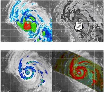
FIGURE 3-2 Illustration of the multiple hurricane eyewalls and rainbands revealed in the microwave (TMI) that are not viewable in infrared (in this case for Hurricane Gert in 1999). Top left: GOES infrared image. Top right: GOES infrared image, Dvorak enhancement. Bottom left: TMI polarization corrected temperatures overlain on GOES infrared. Bottom right: TMI 85 GHz “color” composite image with GOES infrared outside of TMI swath. SOURCE: Naval Research Laboratory Tropical Cyclone Web Page Team.
-
Tropical cyclone monitoring at the Air Force Weather Agency. The Air Force Weather Agency’s Omaha, Nebraska, tropical cyclone satellite fixing center has used TMI data since 1998 because of TMI’s ability to see through non-raining upper-level clouds. The agency provides near-real-time tropical cyclone fixes globally to JTWC; NOAA’s Tropical Prediction Center, Satellite Analysis Branch, and Tropical Satellite Analysis Branch; the Central Pacific Hurricane Center; and the Navy’s regional center at Norfolk, Virginia.
-
Rainfall estimation using PR and TMI at the Naval Research Laboratory. TRMM PR and TMI data are used in the Naval Research Laboratory’s merged rainrate method. This method also incorporates cloud-top temperatures from five geostationary imagers (GOES-EAST/WEST, GOES-9, and Meteosat-5/7). The rainrate product has been used by several operational forces, including those in Operation Iraqi Freedom (Turk et al., 2002, 2003; Miller et al., 2004).
International Uses of TRMM
Tropical Cyclone Forecasting
Numerous agencies worldwide, including the six World Meteorological Organization Regional Specialized Meteorological Centers (Japan Meteorological Agency, India Meteorological Center, Meteo France, NOAA’s National Hurricane Center and Central Pacific Hurricane Center, and the Fiji Meteorological Service) are using TMI data in an operational mode for tropical cyclone analysis. In addition, the tropical cyclone warning centers in Australia and New Zealand routinely incorporate TMI data in their tropical cyclone forecasting. Indeed, at the 2002 International Workshop on Tropical Cyclones in Cairns, Australia, presenters from many countries indicated they routinely incorporated TMI imagery into their operations (see Elsberry and Velden, 2003). These data are served through tropical cyclone Web pages introduced by the Naval Research Laboratory and tranferred to the Fleet Numerical Meteorology and Oceanography Center. For some presenters, this workshop marked the first time they became aware of the Website and the data it serves.
The data are used for detecting location and intensity of tropical cyclones because of their high spatial resolution combined with the capability of the 37-GHz channel to resolve tropical cyclone eyewall features and their temporal gap-filling attributes.
The Japan Meteorological Agency (JMA) uses both internally generated TMI and PR products as well as TMI data from the Naval Research Laboratory/ FNMOC for analysis of typhoons approaching Japan. The Naval Research Laboratory receives email from JMA and other World Meteorological Organization centers when its tropical cyclone Web page temporarily goes offline, emphasizing the near-real-time need that TRMM data fulfills.
Numerical Weather Prediction
JMA and the European Centre for Medium-Range Weather Forecasts (ECMWF) have led the way in using TRMM data in numerical weather prediction. JMA is assimilating TMI observations into its global model and ECMWF has conducted a series of near-real-time experiments with its 4-DVAR operational
forecast system and plans to go fully operational with the TRMM data assimilation pending the decision to extend the TRMM mission.
Precipitation “Nowcasting”
Many countries are now creating and distributing nowcast rain products and serve a host of users including hydrologists, farmers, weather forecasters, numerical modelers, the military, and the climate community. For example, rainfall analyses that capture extensive rain events or rain over specific flood-prone geographic regions25 are being used in near real time to create weather hazard warnings that guide the evacuation of people and resources. These rain datasets are being incorporated into hydrological surface runoff models to predict rapidly changing downstream effects (Lee and Anagnostou, 2004).
Nowcast rain products are undergoing extensive validation against ground truth rain gauges, radar, and combined precipitation datasets. And nowcasting has reached new levels of fidelity by incorporating microwave remotely sensed data. Earlier infrared-only algorithms were limited by the poor correlations between cloud-top temperatures and actual rainfall and thus physical retrievals using passive microwave imagers such as SSM/I and TMI data brought greater accuracy. However, microwave imagers do not provide the temporal sampling required for rapidly changing rain events. Consequently, “merged” infrared-microwave techniques evolved, and infrared data from geostationary satellites are trained using microwave imagers. The TRMM PR rainrate data serve as the cross-calibration source for both. Hence, the PR rainrate measurements are crucial for enhancing the accuracy of the final merged rainrate product: they are the key factor in deriving accurate global and mesoscale rain analyses.
OPERATIONAL COMMUNITY JUST BEGINNING TO ADOPT PR DATA
It is evident from the previous section that TMI data currently fill the great majority of operational uses of TRMM data. The operational community has not been able to make extensive use PR data because of
-
the data having only recently become available in near real time to the broader community outside of NASA and JAXA,
|
25 |
See, for example, NASA’s TRMM Website (http://trmm.gsfc.nasa.gov/) and especially the page alerting users to potential flooding areas (http://trmm.gsfc.nasa.gov/publications_dir/potential_flood.html). |
-
the new and unique nature of the PR data and the learning required to exploit them,
-
the perceived experimental nature and finite lifetime of the PR, and
-
the lack of sophistication in the representation of cloud and precipitation physics in current operational forecast models and global climate models that prevents them from taking advantage of the native resolution of the PR data.26
Cloud-resolving models that are currently under development will require the PR data in order to develop and validate the high-resolution model physics.27
FINDINGS
NASA and JAXA are to be commended on the highly successful TRMM satellite whose achievements and longevity have exceeded even the optimistic expectations at the time of launch. These agencies are also to be commended for their visionary actions to extend the lifetime of TRMM beyond the original anticipated maximum length of the mission thereby enhancing the value of the data from TRMM to science and operations.
FINDING 3.1: TRMM has two unique attributes that make it ideal for observing tropical rainfall systems: (1) its suite of complementary observing instruments and (2) its orbital characteristics.
-
The PR is the only precipitation radar in space and provides direct, fine-scale observations of the three-dimensional structure of precipitation systems. The combination of PR and LIS observations provides a measure of convective intensity.28 The combination of PR, TMI, and VIRS observations from the same platform serves, in effect, as a “Rosetta Stone” for cross-calibration of the indirect estimates of precipitation from microwave, visible, and infrared observations.
-
The TRMM orbit (low-altitude, non-sunsynchronous, precessing, 35-degree tropical inclination) provides sampling in the tropics that is far more frequent, and far more spatially comprehensive, than that obtained from standard polar orbiter satellites.
FINDING 3.2: TRMM has achieved its original science goals and produced a greater than expected range of scientific results in
-
climate and weather research (e.g., a reliable seven-year climatology of the mean annual tropical rainfall and its interannual and diurnal cycles; fundamental new information on the synoptic climatology of tropical weather systems, e.g., the first detailed precipitation and latent heating profiles throughout the tropics and subtropics, first detailed convective and stratiform rainfall structure, and a description from space of the fine-scale structure of rainfall systems that can only be determined from the PR data; understanding of how sea surface temperature (SST) patterns modify precipitation through air-sea interaction; quantitative documentation of precipitation patterns; mapping sea surface temperature through clouds for improved climate records; demonstrating the effect of pollution and other human influences on precipitation formation); and
-
applied research (e.g., a wealth of climatological and diagnostic information on tropical rainfall; insight into the physical processes of precipitation formation; unique, fine-scaled information on hurricane and typhoon structure linked to rapid intensification; calibration of a long-term satellite precipitation dataset and multisatellite three-hour analyses; experimental tropical cyclone forecast methods; enhanced SST nowcasting applications using TRMM TMI data; integration of TRMM data into forecast model initialization procedures; enhanced understanding of tropical cyclone inner eyewall dynamics and tropical cyclone intensity).
FINDING 3.3: Since 1998, TRMM has provided near-real-time information for operational purposes. Data from the TMI sensor are most often used. There are four principal applications: (1) monitoring and predicting the future behavior of tropical cyclones, (2) estimating rainfall, (3) predicting weather, and (4) monitoring of climate variability (precipitation and sea surface temperature). Many organizations and individuals have invested in bringing TRMM data into the operational environment because of the unique aspects of TRMM’s orbit and sensor suite. This reflects their professional judgment of the value of doing so based on their experiences of improvements in such things as accuracy of center fixes for tropical cyclones and prediction of storm intensity. Nonetheless, the effect of TRMM data on operational applications has not been widely quantified because the data record is too short for meaningful statistical analysis and no one has done control experiments wherein the TRMM data are eliminated and the analysis is rerun. Further, the socioeconomic effects on end-users of improved forecasts have not been quantified.
In the United States TRMM data are used in operations by organizations in NOAA (e.g., Tropical Prediction Center, NCEP, Satellite Analysis Branch, Aviation Weather Center, Climate Prediction Center, National Climate Data Center) and the Department of Defense (e.g., JTWC, Air Force Weather Agency,
FNMOC, and the Naval Research Laboratory). In addition, TRMM data are used internationally for operations by World Meteorological Organization centers throughout the tropics for monitoring and forecasting tropical cyclone activity. Furthermore, groups in Japan and Europe have begun using TRMM data in numerical weather prediction models. Because TRMM data are already being used operationally (which does not fit with NASA’s primary focus of research and exploration), NASA has sought partnerships with other agencies to fund extension of TRMM. Thus, determining the future of TRMM has become a multi-agency issue.
FINDING 3.4: The TRMM satellite and its sensors remain in excellent condition. There is every reason to believe that they will continue to operate well for the next few years.
FINDING 3.5: TRMM’s potential to help improve forecasts—especially through increased use of PR data in models—has not been fully realized because of
-
the PR data having only recently become available in near real time to the broader community outside of NASA and JAXA,
-
the new and unique nature of the PR data and the learning required to exploit them,
-
the perceived experimental nature and finite lifetime of the PR, and
-
the lack of sophistication in the representation of cloud and precipitation physics in current operational forecast models and global climate models such that they cannot yet take advantage of the native resolution of the PR data.


