
K
Examples of Improvements in Tropical Cyclone Nowcasting Gained from TRMM
INTRODUCTION
Many tropical cyclones hide their true center location under a central dense overcast that obscures the eye and/or eyewall from detection in visible and infrared images. Consequently, storm location estimates from visible and infrared imagery can be off up to 200 km when clouds mask the true storm center. Poor position estimates typically occur during a storm’s formative stages and when the low-level center is not aligned with the central dense overcast’s expansive cloud shield. Tropical Rainfall Measuring Mission (TRMM) Microwave Imager (TMI) data can reveal the storm center by enabling the analyst to find the eye or banding eye features that otherwise would not be visible.
Microwave imagers other than TMI have the same general capability, but only TMI and AMSR-E currently have the 5-km 85 GHz resolution and frequency attributes. TMI’s unique orbit allows it to temporally sample storms when no polar orbiters can, thus filling a data void. In addition, the 35-degree orbital inclination permits TMI data to sample storms during consecutive orbits (for example, three or four orbits for storms approaching Japan). Frequent views provide the continuity to understand the link between storm structure evolution and intensity changes.
The National Hurricane Center and the Joint Typhoon Warning Center routinely incorporate TRMM data to monitor tropical cyclones within their warning areas. This is also the case at the Air Force Weather Agency, NOAA’s Satellite Analysis Branch (Camp Springs, Maryland) and the Tropical Satellite Analysis Branch (Miami, Florida). In 2004, these centers created more than 600 tropical cyclone fixes using TMI data (Table K-1). Because of the high spatial resolution
TABLE K-1 Tropical Cyclone Center Fixes in 2004 (up to December 9)
of TMI data (5 km at 85 GHz), these fixes are typically assigned very high quality when compared with all other satellite location datasets (e.g., visible, infrared, and microwave sensors such as SSM/I and AMSU-B). Thus, the TMI fixes drive both the near-real-time warning positions and typically the best track created when all data is compiled after a storm has completed its life.
The National Hurricane Center and the Joint Typhoon Warning Center include TMI in their storm discussions that outline how the data have affected their warning positions or provided insight on storm structure that directly influences storm intensity estimates and/or short-term intensity trends. This appendix provides examples of how TMI data are used for intensity estimates and fixing storm locations.
SPECIFIC IMPACTS OF TRMM DATA
Tropical Cyclone Maximum Intensity: Kenna
“Now that Kenna [Figure K-1] has developed a vertically deep eye feature in the TRMM data and the center is embedded in the middle of the CDO [Central Dense Overcast] … a 24-hour period of rapid intensification is being forecast.” (From Tropical Storm Kenna Discussion Number 6 at 2 am PDT October 23, 2002.)
Impact of TRMM data: TRMM data led the Tropical Prediction Center to correctly change its forecast from “intensification” to “rapid intensification.”
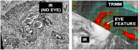
FIGURE K-1 Comparison of TRMM TMI data with GOES Infrared Data Showing the improved ability to detect the eye of Tropical Cyclone Kenna. IR = infrared. SOURCE: Naval Research Laboratory Tropical Cyclone Web Page Team.
Tropical Cyclone Maximum Intensity: Dalila
“A TRMM satellite overpass at 1205Z … showed only a partial eyewall at best … which casts some doubts as to whether Dalila was as strong as previously thought. The maximum winds are decreased to 65 kts for this advisory …” (From Hurricane Dalila Discussion Number 16 at 2 pm PDT July 24, 2001.)
Impact of TRMM Data: The Tropical Prediction Center decreased its estimate of the maximum winds by 5 knots and correctly changed its intensity forecast from “strengthening” to “weakening.”
Tropical Cyclone Position/Track: Felicia
“The cloud pattern is not well organized and the low-level center is very difficult to find on IR [Infrared] images. A 1259Z TRMM pass shows the low level center to the north and well removed from the convection.” (From Tropical Storm Felicia Discussion Number at 8 am PDT July 19, 2003.)
Impact of TRMM data: The data enabled the Tropical Prediction Center to position the center properly.
Tropical Cyclone Size and Structure: Genevieve
“The latest TRMM pass at 0055 UTC indicates Genevieve may not be vertically aligned with different center fixes from the 85 GHz and 37 GHz channels. Thus the initial intensity is held at 60 knots for this advisory.” (From Tropical Storm Genevieve Discussion Number 9 at 8 pm August 27, 2002.)
Impact of TRMM data: NOAA conventional satellite estimates indicated Genevieve was a hurricane with 65 knot winds. TRMM data allowed the Tropical Prediction Center to correctly assess that Genevieve was instead a tropical storm with 60 knot winds. Genevieve never became a hurricane.
Tropical Cyclone Formation and Type: Subtropical Depression 12
“On the other hand … a TRMM overpass at 1601Z indicated that the maximum winds were at least 100 n mi [nautical miles] from the center … which is rather unlike a tropical cyclone. The low is thus upgraded to a subtropical depression instead of a tropical depression.” (From Subtropical Depression Twelve Discussion Number 1 at 5 pm EDT September 20, 2002.)
Impact of TRMM data: The Tropical Prediction Center used TRMM data to properly classify the system a subtropical depression rather than a tropical depression. This distinction is important to users because subtropical systems usually develop less rapidly than tropical systems. This system remained subtropical and developed slowly for the following two days.
Fixing the Center of a Hurricane: Hurricane Kyle
“The first images after the eclipse period were not helpful in determining a center fix for Kyle. However a 0657 UTC TRMM pass provided the additional detail for an accurate fix at synoptic time. The TRMM data also indicates a system that is still vertically aligned.” (From Hurricane Kyle discussion number 31, National Weather Service, Miami, Florida, 5 am EDT, September 28, 2002.)
Impact of TRMM data: First accurate fix of the center of the hurricane.
Advanced Warning of Storm Intensity: Typhoon Vamei
“The TRMM pass triggered the rapid warning on this system with the USS Carl Vinson Battle Group just departing Singapore. With the advance warning they were able to strategize and safely route through the system. The TRMM pass also validated its intensity. Without it, we probably would have warned, but lower (45 knots) based on QUIKSCAT. That’s probably the best example we’ve had to date.” (Source: Joint Typhoon Warning Center.1)
FURTHER EXAMPLES OF TROPICAL CYCLONE DISCUSSIONS THAT ILLUSTRATE OPERATIONAL USE OF TRMM DATA
Tropical Storm Danny Discussion Number 4
NWS TPC/NATIONAL HURRICANE CENTER MIAMI, FL, 5 AM EDT, JULY 17, 2003
“DANNY CONTINUES TO BECOME BETTER ORGANIZED AS INDICATED BY IMPROVED BANDING FEATURES AND A 17/0339Z TRMM OVERPASS INDICATING A 10 NMI DIAMETER EYE-LIKE FEATURE …”
Tropical Storm Blanca Discussion Number 14
NWS TPC/NATIONAL HURRICANE CENTER MIAMI, FL, 2 AM PDT, JUNE 20, 2003
“AFTER BEING DEVOID OF THUNDERSTORM ACTIVITY FOR THE PAST SEVERAL HOURS … NEW PATCHES OF DEEP CONVECTION HAVE RE-DEVELOPED NEAR THE CENTER. DVORAK T-NUMBERS SUGGEST THAT BLANCA IS BARELY A TROPICAL STORM BUT BECAUSE THERE WAS THERE WAS AN EXTREMELY WELL-DEFINED CENTER ON THE 0347Z TRMM PASSAGE … THE INITIAL INTENSITY IS KEPT AT 35 KNOTS AT THIS TIME …”
Tropical Storm Enrique Discussion Number 9
NWS TPC/NATIONAL HURRICANE CENTER MIAMI, FL, 8 AM PDT JULY 12, 2003
“ENRIQUE MAINTAINS AN IMPRESSIVE CONVECTIVE PATTERN … WITH CLOUD TOPS TO -80C NEAR THE CENTER. HOWEVER … A TRMM OVERPASS AT 0802Z SHOWED NO EYE AND A PARTLY EXPOSED LOW-LEVEL CENTER WEST OF MAIN CONVECTIVE BANDS …”
Tropical Storm Felicia Discussion Number 7
NWS TPC/NATIONAL HURRICANE CENTER MIAMI, FL, 8 AM PDT, JULY 19, 2003
“THE CLOUD PATTERN IS NOT WELL ORGANIZED AND THE LOW-LEVEL CENTER IS VERY DIFFICULT TO FIND ON IR IMAGES. A 1259Z TRMM PASS SHOWS THE LOW LEVEL CENTER TO THE NORTH AND WELL REMOVED FROM THE CONVECTION. A SLIGHT STRAIGHTENING IS POSSIBLE BEFORE WEAKENING OVER COOL WATERS BEGINS IN ABOUT 36 HOURS …”
Hurricane Ignacio Discussion Number 11
NWS TPC/NATIONAL HURRICANE CENTER MIAMI FL, 8 AM PDT, AUG 24, 2003
“IGNACIO HAS CONTINUED TO STRENGTHEN … WITH A SMALL EYE EMBEDDED IN VERY COLD-TOPPED CONVECTION … ALTHOUGH RECENT ENHANCED IR IMAGES SHOW SOME WARMING OF THE CLOUD TOPS. TRMM DATA SHOWED A 10 N MI DIAMETER EYE WITH A WELL-DEFINED EYEWALL … AND FIRST-LIGHT VISUAL PICTURES SHOW A CLOUD-FILLED EYE …”
Hurricane Ignacio Discussion Number 12
NWS TPC/NATIONAL HURRICANE CENTER MIAMI FL, 2 PM PDT, AUG 24, 2003
“THE INTENSIFICATION EVENT NOTED EARLIER TODAY HAS ENDED. TRMM AND SSM/I IMAGERY SUGGEST THAT IGNACIO HAS GONE THROUGH AN EYEWALL REPLACEMENT … WHICH COULD EXPLAIN THE RECENT LEVELING OFF IN INTENSITY …”
Hurricane Jimena Discussion Number 6
NWS TPC/NATIONAL HURRICANE CENTER MIAMI FL, 8 AM PDT AUG 29, 2003
“ENHANCED INFRARED AND MICROWAVE IMAGERY DEPICT THAT JIMENA CONTINUES TO INTENSIFY. DVORAK INTENSITY ESTIMATES ARE 77 KT FROM TAFB … 65 KT FROM SAB … 55 KT FROM CPHC AND 55 KT FROM AFWA. A 0923Z TRMM PASS REVEALED A DISTINCT … SMALL EYE BENEATH THE DEEP CONVECTION. BASED ON THIS DATA … THE TROPICAL STORM IS UPGRADED TO HURRICANE JIMENA WITH 65 KT SUSTAINED WINDS …”
Hurricane Jimena Discussion Number 15
NWS CENTRAL PACIFIC HURRICANE CENTER HONOLULU HI, 5 AM HST, AUG 31, 2003
“HURRICANE JIMENA INTENSITY REMAINS AT 90 KNOTS WITH DVORAK SATELLITE INTENSITIES OF 4.5 FROM PHFO AND SAB [Satellite Anaysis Branch] … AND 5.0 FROM JTWC. INITIAL MOTION IS
270/15 KT. BOTH INTENSITY AND MOVEMENT REMAIN UNCHANGED FROM 6 AND 12 HOURS AGO.
UW-CIMSS VERTICAL WIND SHEAR ANALYSIS INDICATES THAT JIMENA CONTINUES TO ENCOUNTER A SOUTH SOUTHWESTERLY SHEAR OF ABOUT 12 KNOTS. OUTFLOW ALOFT IS IMPEDED ON THE WESTERN SIDE OF JIMENA BECAUSE OF THE SHEAR. A TRMM PASS AT 0907Z CENTERING JIMENA AT 17.9N 146.4W SHOWED THAT THE EYEWALL WAS OPEN ON THE SOUTH SIDE. THIS INDICATES THAT THE SYSTEM IS IN A WEAKENING PHASE … PROBABLY BECAUSE OF THE VERTICAL WIND SHEAR AND THE RELATIVELY COOL SEA SURFACE TEMPERATURES OVER WHICH JIMENA IS PASSING …”
Tropical Depression Eleven-E Discussion Number 5
NWS TPC/NATIONAL HURRICANE CENTER MIAMI, FL, 8 AM PDT SEP 04, 2003
“LATEST SATELLITE IMAGERY AND MICROWAVE DATA FROM A 12Z TRMM PASS INDICATE THE CENTER OF TROPICAL DEPRESSION ELEVEN-E IS ABOUT A DEGREE TO THE NORTH OF THE PREVIOUS ADVISORY POSITION. FURTHER RE-LOCATION MAY BE NECESSARY ONCE MORE VISIBLE IMAGES BECOME AVAILABLE. THE DEPRESSION REMAINS A BROAD CIRCULATION AND SATELLITE INTENSITY ESTIMATES FROM BOTH TAFB AND SAB ARE 30 KNOTS. THE INITIAL INTENSITY WILL REMAIN AT 30 KNOTS …”
Tropical Depression Kevin Discussion Number 8
NWS TPC/NATIONAL HURRICANE CENTER MIAMI, FL, 2 AM PDT, SEP 05, 2003
“TROPICAL DEPRESSION KEVIN HAS BECOME A FULLY EXPOSED LOW-LEVEL CIRCULATION. ENHANCED INFRARED SATELLITE IMAGERY AND A 0436Z TRMM PASS DEPICT THAT THE CENTER IS DISPLACED APPROXIMATELY 90 MILES NORTH OF THE DEEP CONVECTION …”
Hurricane Marty Discussion Number 13
NWS TPC/NATIONAL HURRICANE CENTER MIAMI, FL, 8 PM PDT, SEP 21, 2003
“MARTY HAS BECOME MUCH BETTER ORGANIZED DURING THE PAST 6 HOURS. DEEP CONVECTION HAS RE-DEVELOPED OVER THE LOW-LEVEL CENTER AND A RAGGED CLOUD-FILLED EYE HAS BRIEFLY APPEARED IN BOTH VISIBLE AND INFRARED SATELLITE IMAGERY. HOWEVER … A 21/1926Z TRMM OVERPASS SHOWED A WELL-DEFINED LOW- TO MID-LEVEL EYE … SUGGESTING THAT THE INNER-CORE WIND FIELD REMAINED WELL ORGANIZED DRUING THE EARLIER WEAKENING PHASE …”


