
3
Critical Needs for Today
U.S. satellite observing systems are undergoing a major transition. NASA’s Earth Observing System (EOS) has been launched and is producing an extraordinary array of science, yet almost no new research missions are planned or are in development. The National Polar-orbiting Operational Environmental Satellite System (NPOESS), scheduled for launch in late 2009, will replace polar-orbiting weather satellites flown separately by NOAA and the Department of Defense. It will be preceded by a transitional and risk-reduction mission to be launched in late 2006, the NPOESS Preparatory Program (NPP). And beginning in 2012, NOAA’s Geostationary Operational Environmental Satellite (GOES) will be upgraded to improve weather forecasts, hazard monitoring, and atmospheric research.
The decisions behind these transition plans, many of them made during the 1990s, both create and limit the opportunities that are available over the next decade and beyond. For example, the decision to integrate climate observations into NPOESS creates some efficiencies. But it also introduces significant compromises in instrument and information system capabilities and limitations in the resulting value of the observations for climate applications.
The U.S. government’s historic approach of dividing responsibility for Earth observations also constrains what new missions can be flown. Under the current arrangement, NASA is responsible for research missions, NOAA is responsible for operational missions, and the USGS has certain responsibilities for the Landsat missions and for land-based monitoring systems. However, as research and operational applications become more tightly integrated, it will be necessary to reconsider how to manage these functions and accelerate the rate of transition of research results to operational products of use to society.1
The ability to capitalize on previous research for both new science and societal applications requires a robust scientific and technological program aimed at making systematic progress in understanding Earth as a system and creating new knowledge and applications. This interim report focuses on actions required
within the next year; it is based on the committee’s review and analysis of mission plans that were current as of April 2005. The committee did not attempt to evaluate new missions—a task whose results will be presented in the committee’s final report in late 2006.
As a result of recent mission cancellations, budget-induced delays, and mission descopes, the committee finds the existing Earth observing program to be severely deficient. The near-term recommendations presented below describe the minimum set of actions needed to maintain the health of the NASA scientific and technical programs until more comprehensive community recommendations are made in the committee’s final report. They address deficiencies in the current program at NASA and some of the emerging needs of NOAA and the USGS. The recommendations address issues in six interrelated areas:
-
Canceled, descoped, or delayed Earth observation missions;
-
Prospects for the transfer of capabilities from some canceled or descoped NASA missions to NPOESS;
-
The adequacy of the technological base for future missions;
-
The status and future prospects of NASA Earth science Explorer-class missions;
-
The adequacy of research and analysis programs to support future programs; and
-
Development of baseline climate observations and data records.
Table 3.1 summarizes a number of recent Earth observing missions or mission programs that have been canceled, descoped, or delayed. The instruments on all of these missions have been demonstrated technologically and are ready for near-term launch. All have important societal applications, as discussed below.
TABLE 3.1 Canceled, Descoped, or Delayed Earth Observation Missions
|
Mission |
Measurement |
Societal Benefit |
Status |
|
Global Precipitation Measurement (GPM) |
Precipitation |
Reduced vulnerability to floods and droughts; improved capability to manage water resources in arid regions; improved forecasts of hurricanes |
Delayed |
|
Atmospheric Soundings from Geostationary Orbit (GIFTS—Geostationary Imaging Fourier Transform Spectrometer) |
Temperature and water vapor |
Protection of life and property through improved weather forecasts and severe storm warnings |
Canceled |
|
Ocean Vector Winds (active scatterometer follow-on to QuikSCAT) |
Wind speed and direction near the ocean surface |
Improved severe weather warnings to ships at sea; improved crop planning and yields through better predictions of El Niño |
Canceled |
|
Landsat Data Continuity—bridge mission (to fill gap between Landsat-7 and NPOESS) |
Land cover |
Monitoring of deforestation; identification of mineral resources; tracking of the conversion of agricultural land to other uses |
Canceled |
|
Glory |
Optical properties of aerosols; solar irradiance |
Improved scientific understanding of factors that force climate change |
Canceled |
|
Wide Swath Ocean Altimeter (on the Ocean Surface Topography Mission; OSTM) |
Sea level in two dimensions |
Monitoring of coastal currents, eddies, and tides, all of which affect fisheries, navigation, and ocean climate |
Instrument canceled—descope of an enhanced OSTM |
The committee’s conclusions and recommendations regarding these missions are presented in the sections that follow.
PROCEED WITH GPM AND GIFTS
Global Precipitation Measurement
In spite of steady advances in weather predictions and warnings, society is increasingly vulnerable to costly floods and droughts.2 Accurate measurement and prediction of precipitation are essential to reduce this vulnerability and improve the management of water resources. Such measurements can be obtained from spaceborne active microwave sensing (radar), which provides direct, fine-scale observations of the three-dimensional structure of precipitation systems.
The first spaceborne precipitation radar, on the Tropical Rainfall Measuring Mission (TRMM), was launched in 1997 and provided insights into the microphysical dynamics of the formation of precipitation. These measurements led to improved operational forecasts of precipitation and estimates of hurricane storm tracks, which in turn have almost certainly reduced economic losses and saved lives.3 TRMM has already exceeded its planned lifespan, and a replacement, the Global Precipitation Measurement (GPM) mission, will be built in partnership with Japan, Europe, and possibly France and India. GPM will consist of a core satellite with a precipitation radar and an advanced radiometer, accompanied by approximately seven satellites with passive radiometers. The GPM constellation will provide global coverage at 3-hour intervals over most land and ocean areas (latitude 65° S to 65° N).
GPM was originally planned to be launched in 2007, which would have minimized the gap in global precipitation coverage after TRMM ended. However, the current estimated launch date is 2010. The committee is pleased to see that GPM is in NASA’s proposed FY 2006 budget but is concerned that the planned launch date has slipped 3 years since initial planning.
The committee recommends that the Global Precipitation Measurement mission be launched without further delays.
Atmospheric Soundings from Geostationary Orbit
Atmospheric soundings of temperature and water vapor are routinely made from polar-orbiting satellites, and they contribute essential observations for weather forecasting. However, the time between soundings from a single polar-orbiting satellite is approximately 12 hours, and this sampling frequency is too low for observing the development of and the rapid changes associated with severe weather, including tornadoes, flash floods, and hurricanes. High-frequency soundings over the United States are being made from geostationary orbit, and there is a plan to upgrade these and other capabilities in 2012 with the launch of the next-generation operational GOES sounder, GOES-R. The Geostationary Imaging Fourier Transform Spectrometer (GIFTS) is a new technology that is designed to obtain 80,000 closely spaced
|
2 |
For instance, the 1988 central U.S. drought is estimated to have cost $40 billion to $60 billion. See information compiled by NOAA’s National Climatic Data Center at <http://www.ncdc.noaa.gov/oa/reports/billionz.html>. Global flood losses over the last decade have exceeded $200 billion, according to the Munich Reinsurance Company, World Map of Natural Hazards, Munich, Germany, 1998. |
|
3 |
Although TRMM data contribute to El Niño predictions, the socioeconomic effects of TRMM-improved forecasts have not yet been quantified. See National Research Council, Assessment of the Benefits of Extending the Tropical Rainfall Measuring Mission: A Perspective from the Research and Operations Communities, Interim Report, The National Academies Press, Washington, D.C., 2005, in press. |
horizontal (~4-kilometer), high-vertical-resolution (~1-kilometer) atmospheric temperature and water vapor soundings every minute from geostationary orbit.4 The high-vertical-resolution water vapor flux measurements also provide a measure of the winds. These measurements will significantly improve numerical weather prediction and severe weather warnings.
The components of GIFTS have been developed with more than $100 million of prior NASA support5 and are being assembled as a prototype for GOES-R risk reduction. However, facing budget problems that were partly the result of the Navy’s withdrawal of its planned support for a spacecraft and launch vehicle, NASA discontinued funding for the GIFTS project beyond FY 2005. The result was a shortfall in funds needed to complete the fabrication and testing of the GIFTS instrument. NOAA provided additional financial support to complete integration of the components of GIFTS and carry out thermal vacuum tests, which will be completed later in 2005. But no funds have been identified to finish the space qualification of GIFTS, and a space mission opportunity has not yet been secured. A World Meteorological Organization (WMO)-led international effort (International Geostationary Laboratory, IGeoLab)6 is getting underway to test GIFTS in space. The plan is to position GIFTS over different regions of Earth to demonstrate the global value of the observations and to prepare the international community for the use of similar data from future operational geostationary satellites. This test could occur as early as 2008, providing 4 years of useful data before the launch of GOES-R.
The committee recommends that NASA and NOAA complete the fabrication, testing, and space qualification of the GIFTS instrument and that they support the international effort to launch GIFTS by 2008.
EVALUATE PLANS FOR TRANSFERRING NEEDED CAPABILITIES TO NPOESS
Instruments on three canceled missions may either be transferred from NASA or replaced with other instruments for flight on NPOESS. These instruments would provide a capability to measure ocean vector winds, land surface changes, aerosol properties, and solar irradiance. Transferring these capabilities from independent NASA missions to NPOESS brings advantages (e.g., transfer of research capabilities to operational use) and disadvantages (e.g., decreased instrument capability, data gaps), as discussed below.
Ocean Vector Winds
Measurements of wind speed and direction near the ocean surface (ocean winds) by satellite observation systems are crucial for monitoring the motion of the atmosphere and oceans and their interaction.7 In particular, accurate knowledge of ocean winds is vital to studies of air-sea interactions,8 ocean circula-
|
4 |
See <http://cimss.ssec.wisc.edu/itwg/itsc/itsc13/proceedings/session7/7_1_lemarshall.pdf>. |
|
5 |
Personal communication, R. Reisse, NASA GIFTS project manager, March 8, 2005. |
|
6 |
|
|
7 |
Although instruments on buoys and ships provide measurements of surface wind vectors, their coverage is insufficient to provide a global wind map. In contrast, satellite-based sensors can provide near-global coverage in one day. Moreover, QuikSCAT ocean winds have proven to be highly accurate. See M.H. Freilich and R.S. Dunbar, “The Accuracy of the NSCAT 1 Vector Winds: Comparisons with National Data Buoy Center Buoys,” J. Geophys. Res. 104(C5): 11231, 1999. |
|
8 |
For example, ocean wind data will support an NSF-sponsored field program (Clivar Mode Water Dynamics Experiment) to study the details of air-sea interaction and improve climate models. |
tions, and El Niño forecasts.9 Accurate ocean winds also improve weather forecasts and storm warnings. The use of QuikSCAT wind data, for example, improved National Weather Service forecasts of the four hurricanes that devastated the southeast United States in 2004 and marine warnings to ships at sea.10 Furthermore, by improving the ability to anticipate how climate and weather will change from one season or year to the next, ocean winds can help us to better manage global agriculture, water reserves, and other resources.
Microwave scatterometers have been flown by NASA and the European Space Agency since 1991, and ocean wind data have been assimilated into weather forecast systems for several years. The current scatterometer—SeaWinds—was launched in 1999 on NASA’s QuikSCAT satellite as a “quick recovery” mission intended to fill the data gap when the satellite hosting the NASA Scatterometer (NSCAT) lost power in June 1997. QuikSCAT has already exceeded its planned 3-year lifetime, but the follow-on NASA mission (Ocean Vector Winds mission), originally scheduled for launch in 2008, has been canceled by NASA.
Both active (radar) and passive (radiometer) microwave sensors are capable of determining ocean surface wind speed, and active microwave instruments are also used to derive the wind direction. The European Space Agency plans to launch an active scatterometer instrument (the Advanced Scatterometer, ASCAT) on its MetOp-1 satellite in late 2005.11 However, it has only about half of the coverage of QuikSCAT (two narrower bands with a gap in the middle). Moreover, significant improvements to weather forecasts require more than one instrument because of the large space between swaths.12
A passive microwave sensor (Windsat13) has been launched to test the technology for the Conical Scanning Microwave Imager/Sounder (CMIS) instrument, which will be launched on the first NPOESS.14 Preliminary analysis suggests that such passive systems will produce wind observations with less accuracy and with more contamination by rain and land than active scatterometers.15 As a result, the substitution of passive microwave sensor data for scatterometry data would worsen El Niño and hurricane forecasts and weather forecasts in coastal areas.16
|
9 |
In an El Niño year, changes in wind and ocean circulation alter typical rainfall patterns and result in the release of large amounts of heat into the atmosphere. The subsequent energy propagates within the atmosphere, affecting the weather in various ways and places and disrupting the normal rhythm of life across the Pacific Ocean. The ability to accurately predict El Niño is of great benefit to the United States and to countries around the world. |
|
10 |
NASA/NOAA workshop, “Satellite Measurements of Ocean Vector Winds: Present Capabilities and Future Trends,” Florida International University, Miami, Florida, February 8-10, 2005. See presentations at <http://cioss.coas.oregonstate.edu/CIOSS/workshops/miami_meeting/Agenda.html>. A forecaster from the National Centers for Environmental Prediction’s Tropical Prediction Center stated that “without QuikSCAT they would be forecasting in the dark.” |
|
11 |
|
|
12 |
R. Knabb, C. Hennon, D. Brown, J. Franklin, H. Cobb, J. Rhome, and R. Molleta, “Impact of QuikSCAT on Tropical Prediction Center Operations,” presentation at NASA/NOAA workshop, Florida International University, Miami, Fla., February 8-10, 2005; see presentation at <http://cioss.coas.oregonstate.edu/CIOSS/workshops/miami_meeting/Agenda.html>. |
|
13 |
Unfortunately, shortly before this report was completed (early May 2005), Windsat suffered a mission-threatening on-orbit failure. |
|
14 |
Windsat was built by the Naval Research Laboratory, with cooperation from NASA, the Air Force, and the NPOESS Integrated Program Office. |
|
15 |
M.H. Freilich and B.A. Vanhoff, “The Accuracy of Preliminary Windsat Vector Wind Measurements: Comparisons with NDBC Buoys and QuikSCAT,” IEEE Trans. Geosci. Remote Sensing, 2006, in press. |
|
16 |
The passive system does not provide useful wind direction for winds of 5 meters per second or less (scatterometer threshold is 2 meters per second). Moreover, wind direction errors for winds at 6 to 8 meters per second (the wind speed range that forces ENSO events) will be double that of the scatterometer. The median global wind speed is about 7 meters per second, which suggests that a passive system will not provide reliable information on direction for half of the winds. In addition, rain and land contamination of wind vectors will be greater from a passive system than from a scatterometer, which limits their use in forecasts of hurricanes and weather in coastal regions. Windsat is comparable in quality to QuikSCAT for wind speeds greater than 8 meters per second, in the absence of rain. However, forecasters at a recent workshop noted that even the relatively small dropout rate of QuikSCAT data from rain was a concern. See presentations at a NASA/NOAA workshop, “Satellite Measurements of Ocean Vector Winds: Present Capabilities and Future Trends,” Florida International University, Miami, Fla., February 8-10, 2005, at <http://cioss.coas.oregonstate.edu/CIOSS/workshops/miami_meeting/Agenda.html>. |
Landsat Data Continuity
Landsat has provided the longest and best-calibrated time series of information about changes in land cover and land use for over 30 years. Today, however, the continuity of this data record is at risk. Despite the varied ongoing uses of Landsat data, the program has not been put on a truly operational basis. The current mission—Landsat 7—is operating in a diminished capacity17 and has exceeded its design life, and NASA has canceled the Landsat Data Continuity Mission.18
The plan outlined in the president’s FY 2006 budget is to have NASA provide an Operational Land Imager (OLI) for flight on the first NPOESS platform. This decision increases the likelihood that critical land cover measurements will be sustained during the NPOESS era. However, since the scan line connector malfunctioned in 2003, Landsat 7 has not been able to achieve the goal of refreshing the global data set seasonally. Consequently, a significant data gap in the Landsat record is already occurring. Actions proposed in NASA’s FY 2006 plan will further increase this data gap, and the gap will obviously be considerably longer if the NPOESS launch date is delayed.
The gap cannot be completely filled by land surface data collected by commercial and foreign sources. Each of these alternative sources has disadvantages, including the high cost of purchasing data or reprogramming algorithms to analyze the data, lack of calibration, and limited geographic coverage. Moreover, the proposed use of the large NPOESS platform to acquire Landsat-type imagery raises technical concerns, including the demands of the imager on the volume and throughput of data systems, and the influence of the jitter of a large platform on the image quality.
Aerosols and Total Irradiance Monitor—Glory
The Glory mission,19 which was to fly the Advanced Polarimetric Sensor (APS) to measure optical properties of aerosols and the Total Irradiance Monitor (TIM) to measure solar irradiance, is slated for cancellation. The Glory mission would provide data essential for climate research and prediction—it would yield the first global aerosol measurements with composition specificity and precise microphysical data on both aerosols and cloud particles needed to infer direct and indirect aerosol climate forcings. It also would ensure continuity of the solar irradiance time series, which goes back to 1978 and whose value would be diminished should there be any gap in the measurement.20
|
17 |
In June 2003 a failure of the scan line corrector (SLC) diminished the capability of the ETM+ (Enhanced Thematic Mapper, plus) instrument. For a description of the problem, see <http://landsat.usgs.gov/pdf/2003junelmu.pdf>. Without the SLC, the sensor still provides coverage of approximately 78 percent of each scene. However, the temporal repeat frequency of coverage has been severely affected and now takes two or more acquisitions to produce one complete view. |
|
18 |
NASA and the Department of the Interior/USGS initially planned to avoid a data gap after Landsat 7 by implementing a Landsat Data Continuity Mission (LDCM) that would procure data from a privately owned and commercially operated remote sensing system. Following an evaluation of proposals, NASA declined to accept any offers and canceled this plan in September 2003. A memorandum from the Office of Science and Technology Policy (OSTP), signed on August 13, 2004, by OSTP Director John Marburger III, states that “the Departments of Defense, the Interior, and Commerce and the National Aeronautics and Space Administration have agreed to take the following actions: (1) Transition Landsat measurements to an operational environment through the incorporation of Landsat-type sensors on the National Polar-orbiting Operational Environmental Satellite System (NPOESS) platform; (2) Plan to incorporate a Landsat imager on the first NPOESS spacecraft (known as C-1), currently scheduled for launch in late 2009; (3) Further assess options to mitigate the risks to data continuity prior to the first NPOESS-Landsat mission, including a ‘bridge’ mission.” The bridge mission is no longer an option in the President’s FY 2006 budget. The OSTP memorandum can be found at the NASA LDCM Web site at <http://ldcm.nasa.gov>. |
|
19 |
See <http://www.esa.ssc.nasa.gov/m2m/mission_report.aspx?mission_id=233>. |
The cancellation of the Glory mission is especially worrisome because just last year, at the January 2004 meeting of the American Meteorological Society, NASA Administrator Sean O’Keefe called for accelerating the flight of the Glory mission to meet NASA’s commitment to the CCSP.21 To go from acceleration to cancellation in 1 year may reflect programmatic and other difficulties for Earth sciences at NASA in general. However, the cancellation has also had impacts on the NPOESS program.
The APS had originally been scheduled to fly on NPOESS in 2010, but when NASA chose its own procurement path for the APS instrument on Glory, the Integrated Program Office for NPOESS significantly delayed its procurement plans for APS. As a consequence, if the APS procurement is reinstated in NOAA plans, the instrument will not be available to fly until 2012 at the earliest. However, the APS and TIM instruments can fly on the first NPOESS mission if NASA builds them and pays for their integration costs.
This record of start then stop, of acceleration then delay, and of canceling important missions without notice is at odds with NASA’s stated science goals and commitment to the CCSP. Moreover, decisions to transfer capabilities from NASA to NOAA were not always made after an appropriate study of the advantages and disadvantages of an NPOESS solution, or with adequate consultation with the scientific and user community. The committee recognizes that there are substantial competing demands on NASA’s budget and that additional funds will be needed to fully address the recommendations in this report.
The committee recommends that NASA, NOAA, and the USGS commission three independent reviews, to be completed by October 2005, regarding the Ocean Vector Winds, Landsat Data Continuity, and Glory missions.22The reviews should evaluate:
-
The suitability, capability, and timeliness of the OLI and CMIS instruments to meet the research and operational needs of users, particularly those that have relied on data from Landsat and QuikSCAT;
-
The suitability, capability, and timeliness of the APS and TIM instruments for meeting the needs of the scientific and operational communities;
-
The costs and benefits of launching the Landsat Data Continuity and Glory missions prior to and/or independently of the launch of the first NPOESS platform; and
-
The costs and benefits of launching the Ocean Vector Winds mission prior to or independently of the launch of CMIS on NPOESS.
|
20 |
Six overlapping satellite experiments have monitored solar irradiance since late 1978: (1) NOAA’s Nimbus-7 Earth Radiation Budget (ERB) experiment (1978-1993), (2) NASA’s Active Cavity Radiometer Irradiance Monitor (ACRIM) 1 on the Solar Maximum Mission (1980-1989), (3) NASA’s Earth Radiation Budget Experiment on the Earth Radiation Budget Satellite (ERBS) (3 missions, running from 1984 to today), (4) NASA’s ACRIM2 on the Upper Atmosphere Research Satellite (1991-2001), and (5) NASA’s ACRIM3 on the ACRIMSAT satellite (2000 to present). The European Space Agency’s SOHO/VIRGO experiment also provided an independent data set during the period from 1996 to 1998. |
|
21 |
O’Keefe noted, “Nearly three years ago the President announced a significant Climate Change Research Initiative that now engages the talents of several federal agencies, including NASA. The Administration’s decadal strategic plan for Climate Change Science calls for three major areas of emphasis to accelerate the availability of the scientific information and models needed to help inform policy decisions. The first area of emphasis is on the emerging science of non-CO2 greenhouse gas forcing, especially aerosols; carbon over North America; and climate feedbacks involving clouds, water vapor, and Polar Regions…. As part of NASA’s commitment to the Climate Change science program, we hope to accelerate the flight of the Glory mission to as early as 2007 to provide earlier availability of this space-based polarimeter that measures the optical properties of aerosols and clouds. This device is slated to become a regular part of the next generation military and civilian weather satellite system.” Remarks given by Sean O’Keefe, American Meteorological Society, Seattle, Washington, on January 11, 2004. See <http://www.nasa.gov/audience/formedia/speeches/ok_meteorological_society_011104.html>. |
|
22 |
Note added in proof: Wording corrected to include the USGS, which was inadvertently omitted in the prepublication copy of this report. |
If the benefits of an independent NASA mission(s) cannot be achieved within reasonable costs and risks, the committee recommends that NASA build the OLI (two copies, one for flight on the first NPOESS platform23), APS, and TIM instruments and contribute to the costs of integrating them into NPOESS. APS, TIM, and the first copy of OLI should be integrated onto the first NPOESS platform to minimize data gaps and achieve maximum utility.
The reviews could be conducted under the auspices of NASA and NOAA and USGS external advisory committees or other independent advisory groups and should be carried out by representative scientific and operational users of the data, along with NOAA and NASA technical experts.
DEVELOP A TECHNOLOGY BASE FOR FUTURE EARTH OBSERVATION
NASA’s Earth Observing System was intended to serve as the foundation for its long-term efforts in Earth science and applications. EOS involves a number of instruments and platforms, a community of world-class scientists, and the infrastructure to consolidate data and information from surface campaigns and remote sensing satellites. The centerpiece of the system is a set of three spacecraft with multiple instruments for studying processes over land, oceans, and atmosphere—EOS Terra, Aqua, and Aura, respectively. Initial plans made in the 1980s called for development of three series of each of these satellites. With launches every 18 to 24 months and replacements every 5 years, NASA hoped to ensure at least a 15-year record of continuous measurements to address the highest-priority science and policy questions, as identified by the interagency Committee on Earth and Environmental Sciences and the Intergovernmental Panel on Climate Change (IPCC).
NASA has changed plans for the EOS series so that now there will be no follow-on spacecraft launched as the second or third elements of Terra, Aqua, or Aura. The development of the longer-term records rests now with the NPOESS, GOES-R, and foreign missions. Aside from selected (and delayed) ESSP missions, the Ocean Surface Topography mission (Jason-2), which no longer has the wide-swath altimeter option, and the Global Precipitation Measurement mission, the NASA program for the future has no explicit set of Earth observation mission plans. Moreover, there is no corresponding research and analysis program for NPOESS as there was for EOS.
Given the long lead times (up to a decade)24 required to identify user needs and develop instrument capabilities, it is essential to have a prioritized science mission strategy based on compelling scientific issues and societal needs and opportunities. Beginning in 2005, the ESSP process will result in a new mission every 2 to 3 years; however, this process is completely inadequate to meet established needs of Earth science or society. Indeed, ESSP was initially conceived as a means to augment the existing EOS line with smaller, more rapid, and technologically flexible missions. Soon there will be little to augment, and the ESSP is, itself, stretched out and delayed.
The absence of a robust set of out-year science missions in active development and in a planning queue is troubling because a number of societally important and scientifically compelling mission con-
cepts are ready to be implemented. Further, the absence of out-year missions will likely result in a stagnant technology base.
The committee’s final report will include a prioritized list of Earth observation missions and activities. This interim report does not preview those recommendations, but the committee can foresee needed technologies for missions that have been under discussion for several years. Three examples with great societal relevance are interferometric synthetic aperture radar, wide-swath ocean altimetry, and measurement of tropospheric winds from space.
Interferometric synthetic aperture radar (InSAR) has demonstrated the capability to make fundamental contributions to understanding the processes that cause earthquakes, volcanic eruptions, and landslides.25 However, existing InSAR satellites, which are being flown by the Canadian and European space agencies, have serious limitations:
-
The radars collect data in the C-band, which does not work well in vegetated areas; and
-
Demand is so high that images are available only for limited areas and at limited times.
Even without these limitations, continued information from these satellites is problematic as they have reached the end of their useful lifetimes.
The shortage of InSAR images will also limit the success of EarthScope, a multi-agency program to explore the three-dimensional structure of the North American continent,26 and efforts to monitor earthquake and volcano hazards around the world. For these reasons, an InSAR mission has emerged as the top priority for the solid-Earth community.27 Investments in the technological base for the L-band are needed to move forward on this mission.
To map the sea-surface height in two dimensions with satisfactory resolution, a new type of radar instrument using the principle of radar interferometry has been developed at the Jet Propulsion Laboratory (JPL). JPL’s wide-swath ocean altimeter has the potential to provide ocean topography over a 200-kilometer-wide swath, providing a two-dimensional image of sea-surface height, rather than a one-dimensional profile. The wide-swath ocean altimeter was being planned for flight on the international Ocean Surface Topography Mission (Jason-2) but was eliminated because of budgetary reasons. This exciting capability enables measurement of small-scale but important phenomena, such as vortices inside ocean currents, which are needed to improve ocean circulation models and to support marine transportation and fisheries research and forecasts.
Global observations of wind fields in the atmosphere are critical for improving weather forecasts, forecasting the trajectory of atmospheric pollutants and pathogens, and better understanding the dynamics of the atmosphere.28 Many instrument and mission designs have been proposed or developed to measure
|
25 |
InSAR measurements of strain over wide geographic areas would also complement the continuous GPS point measurements being collected along the western edge of the United States, Mexico, and Canada through the Plate Boundary Observatory component of the NSF EarthScope initiative. |
|
26 |
National Research Council, Review of EarthScope Integrated Science, National Academy Press, Washington, D.C., 2001. |
|
27 |
National Aeronautics and Space Administration, Living on a Restless Planet, Solid Earth Science Working Group Report, Pasadena, Calif., 2002, <http://solidearth.jpl.nasa.gov/seswg.html>; National Research Council, Review of NASA’s Solid-Earth Science Strategy, The National Academies Press, Washington, D.C., 2004. |
|
28 |
R.M. Atlas, “Atmospheric Observations and Experiments to Assess Their Usefulness in Data Assimilation,” J. Meteorol. Soc. Jpn. 75:111-130, 1997; W.E. Baker, G.D. Emmitt, F. Robertson, R.M. Atlas, J.E. Molinari, D.A. Bowdle, J. Paegle, R.M. Hardesty, R.T. Menzies, T.N. Krishnamurti, R.A. Brown, M.J. Post, J.R. Anderson, A.C. Lorenc, and J. McElroy, “LIDAR-measured Winds from Space: A Key Component for Weather and Climate Prediction,” Bull. Am. Meteorol. Soc. 79:581-599, 1998. |
the global wind field using active remote sensing techniques. In 2008, the European Space Agency will launch its Earth Explorer Atmospheric Dynamics mission (ADM-Aeolus)29 to measure winds in the troposphere using an ultraviolet laser radar (lidar). In the United States, active remote sensing techniques for such measurements are not yet at a comparable level of technology readiness.30
The committee recommends that NASA significantly expand existing technology development programs to ensure that new enabling technologies for new observational capabilities, including interferometric synthetic aperture radar, wide-swath ocean altimetry, and wind lidar, are available to support potential mission starts over the coming decade.
REINVIGORATE THE NASA EARTH EXPLORER MISSIONS PROGRAM
Satisfying tomorrow’s critical societal needs requires us to do exploratory basic science today. In the 1990s, NASA introduced an innovative science mission program called Earth Explorers to do just that. The scientific community has been deeply engaged in planning the Earth System Science Pathfinder (ESSP) missions that fall within the Earth Explorer program. NASA developed its ESSP program as “an innovative approach for addressing Global Change Research by providing periodic ‘Windows of Opportunity’ to accommodate new scientific priorities and expand community participation in NASA’s Earth Science activities. The program is characterized by relatively low to moderate cost, small to medium sized missions that are capable of being built, tested and launched in a short time interval.”31 ESSP missions were intended to be launched at a rate of one or more per year.32 Today, Earth Explorers are being delayed, and there is no comparable program targeted to generate new science.
Explorer-class missions are intended to provide more frequent access to space and to allow for experimentation with new technologies.33 By accepting a higher risk of failure, Explorer-class missions can be developed faster and at lower cost. Although some missions may fail, the net result will be the collection of new or unique scientific data that could not be collected by medium- and large-class missions alone. In addition, an instrument incubator program and related technology development programs foster the development of new technologies that will be used in future ESSP missions.34 As a result, ESSP missions provide an impetus for advancing longer-term spaceborne measurement programs. At the same time, these smaller missions provide opportunities to train and maintain personnel needed for future missions.35
|
29 |
|
|
30 |
See, for example, Space Readiness Coherent Lidar Experiment (SPARCLE), at <http://www.ghcc.msfc.nasa.gov/sparcle/sparcle.html>. Also see presentation to NASA by M.J. Kavaya, U.N. Singh, and F. Amzajerdian, “A New NASA Technology Program for Risk Reduction of Space-Based Lidar Missions,” January 24, 2002, at <http://space.hsv.usra.edu/LWG/Jan02/Papers.jan02/Kavaya2.jan02.pdf>. |
|
31 |
See Earth System Science Pathfinder, at <http://earth.nasa.gov/essp/>. |
|
32 |
This approach corresponds to the original intent of the Earth System Science Pathfinder program, which solicited proposals every 2 years for satellite measurements that were outside the scope of approved Earth science missions. Proposals were solicited in all Earth science disciplines, from which two missions and one alternate were selected based on scientific priority and technical readiness. |
|
33 |
National Research Council, Steps to Facilitate Principal-Investigator-Led Earth Science Missions, The National Academies Press, Washington, D.C., 2004. NASA science missions can be classified into three general categories: exploratory or explorer class (e.g., existing Earth System Science Pathfinder missions), medium class (e.g., TRMM), and large missions (e.g., EOS Terra platform). Explorer-class missions were part of NASA’s Space Science Directorate, but their objectives are very similar to those of the Earth Science Directorate’s ESSP program. |
|
34 |
National Research Council, The Role of Small Satellites in NASA and NOAA Earth Observation Programs, National Academy Press, Washington, D.C., 2000. |
|
35 |
National Research Council, Steps to Facilitate Principal-Investigator-Led Earth Science Missions, The National Academies Press, Washington, D.C., 2004. |
|
BOX 3.1 The Gravity Recovery and Climate Experiment (GRACE) was proposed as part of ESSP-1 in 1996 and selected for development in 1997. GRACE was launched successfully in 2002. It consists of two identical spacecraft that are measuring gravity changes that are 100 to 100,000 times smaller than those measured previously, which occur over weeks compared to years, and in spans of 100 miles versus 500 miles. The mission can sense changes in gravity caused by a deep ocean current shifting or an ice sheet melting in Antarctica. It has also provided the first information about variations in groundwater storage at continental scales, an understanding that may help future missions with more advanced technology focus on global groundwater resources. CloudSat and CALIPSO (Cloud-Aerosol Lidar and Infrared Pathfinder Satellite Observations) were proposed as part of ESSP-2 in 1998 and were confirmed by NASA headquarters and approved to proceed in December 2000. They are now scheduled for launch no earlier than July 31, 2005, and for scheduling reasons are more likely to be launched in September 2005.1 CloudSat will be flown in formation with CALIPSO, which will measure cloud and aerosol composition. These satellites, together with instruments onboard the Aqua platform, will furnish data needed to evaluate and improve the way clouds are parameterized in global models, thereby contributing to better predictions of clouds and thus to the poorly understood cloud-climate feedback problem. The Orbiting Carbon Observatory (OCO) was proposed as part of ESSP-3 in 2001 and selected for mission formulation in 2002. OCO will undergo a confirmation review at the end of April 2005 and is currently scheduled for launch in September 2008 (at the time of final editing of this report, the authors were pleased to learn that OCO was confirmed). Instruments on OCO will measure global concentrations of atmospheric CO2, which can be used to help unravel uncertainties about the fate of global carbon emissions and their ultimate effects on climate. Aquarius was proposed as part of ESSP-3 in 2001 and selected for mission formulation in July 2002. Mission confirmation review for Aquarius is scheduled for September 2005, and launch is now likely no sooner than March 2009.2 Aquarius will measure ocean surface salinity, a key variable that affects ocean circulation and from which patterns of freshwater influxes (via precipitation, river runoff, and melting of ice) and evaporation can be estimated. Hydros was proposed as part of ESSP-3 in 2001, selected as an alternate mission in 2002, and selected for mission formulation in December 2003. Mission confirmation review for Hydros is planned for September 2007, and launch is now scheduled for September 2010.3 Hydros will measure near-surface soil moisture, a key land surface variable that drives evapotranspiration, and hence recycling of moisture to the atmosphere. Soil moisture is also an important determinant of flood susceptibility and can be used as a drought indicator. |
Seven missions have been selected since the ESSP program was initiated in the mid 1990s. Of these, one is collecting data, one (the Vegetation Canopy Lidar mission) was dropped due to concerns about technological readiness, and five are scheduled for launch. The active and planned missions are described in Box 3.1. All of these missions will provide global observations that are difficult or impossible to collect using in situ technologies and that will address gaps in scientific understanding of the Earth system. Many will yield data that will help to reduce uncertainties in the understanding of the climate system, in direct support of the U.S. Climate Change Science Program. In addition, missions including CloudSat and CALIPSO are poised to make significant contributions to the reduction of risk from natural hazards, while missions such as Hydros play a significant role in bridging the gap between research and operations.
Despite the clear successes of the ESSP missions to date and the numerous benefits of the program in terms of technology development, fostering exploratory research, and training new generations of remote sensing scientists, NASA has delayed releasing the announcement of opportunity for the next generation of ESSP missions.36 The committee views this delay with great concern. The committee is also concerned that all of the ESSP-3 missions (OCO, Aquarius, and Hydros) have been delayed, apparently because of inadequate funding, and the latter two now have exceedingly long development times, particularly given their relatively small size and budget.
The committee supports continuation of a line of Explorer-class missions directed toward advancing the understanding of Earth and developing new technologies and observational capabilities, and urges NASA to:
-
Increase the frequency of Explorer selection opportunities and accelerate the ESSP-3 missions by providing sufficient funding for at least one launch per year, and
-
Release an ESSP-4 announcement of opportunity in FY 2005.
STRENGTHEN BASELINE CLIMATE OBSERVATIONS AND CLIMATE DATA RECORDS
Baseline Climate Observations
It is essential that we know how and why Earth’s climate is changing. Considerations of Earth’s variable and changing climate increasingly affect government and business decisions that have large financial consequences. These decisions cannot be made wisely without accurate knowledge of the climate today and how it is changing, or without the capability to predict what it will be in the future. Current and planned observing systems are inadequate for this task.
The committee is pleased that a critical near-term objective for both GEOSS and the CCSP is to establish baseline observations from which to describe climate variability and change.37 Such baseline observations provide a means of monitoring climate change and testing climate models and forecasts. Two examples demonstrate the importance of long-term, accurate measurements of key observables: (1) the
|
36 |
According to the NASA ESSP Web site at <http://earth.nasa.gov/essp/>, a draft announcement of opportunity was expected in the summer of 2004; this site now states that the announcement will not be out before December 2004. The announcement had not been made when the prepublication copy of this report was released (May 2005). |
|
37 |
See Climate Change Science Program and Subcommittee on Global Change Research, Our Changing Planet: The U.S. Climate Change Science Program for Fiscal Years 2004 and 2005, 2004, at <http://www.usgcrp.gov/usgcrp/Library/ocp2004-5/ocp2004-5.pdf>; see also Ad-hoc Group on Earth Observations, Global Earth Observing System of Systems: 10-Year Implementation Plan Reference Document, GEO204, ESA Publications Division, The Netherlands, 2005, at <http://earthobservations.org/docs/GEO204%20Final%20Draft%20Reference%20Document.pdf>. |
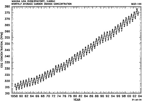
FIGURE 3.1 Carbon dioxide measured at Mauna Loa since 1958. This is the longest record of carbon dioxide measurements. SOURCE: C.D. Keeling and T.P. Whorf, “Atmospheric CO2 Records from Sites in the SIO Air Sampling Network,” in Trends: A Compendium of Data on Global Change, Carbon Dioxide Information Analysis Center, Oak Ridge National Laboratory, Oak Ridge, Tenn., 2004.
trend of CO2 concentrations measured at Mauna Loa by Charles Keeling and associates since 1958, and (2) the observation of surface and atmospheric mean temperature, which is based on various instrument records (Figure 3.1 and Plate 3). Both records show that trends in global indicators are far more informative and compelling than single values. However, the uncertainty associated with the two trends is vastly different. The CO2 record is tied to absolute standards, open to the scientific community for scrutiny, and incontrovertible. Virtually all scientists agree that carbon dioxide in the atmosphere has been increasing over this period to the accuracy reported in the Keeling record. In contrast, the temperature record contains significant uncertainty, and there have been serious questions in the scientific community over the past two decades about (1) how much and where the global atmosphere is warming and (2) whether that record can distinguish between different model projections of climate change.38
The answers to such questions have significant policy implications. For example, a doubling of CO2 is forecast to increase global average temperatures by 1.5 to 5°C, but to increase regional temperatures over
populated continental zones of the mid-to-high latitudes of the Northern Hemisphere by 4 to 10°C.39 These changes are, by any measure, rapid and important to people, societies, and the environment, and they underscore the need for decision support tools based on a foundation of tested and trusted baseline global climate observations and on credible long-term climate forecasts.
The design of climate observing and monitoring systems must ensure the establishment of global long-term climate records that are of high accuracy and precision,40 tested for systematic errors on-orbit, and tied to irrefutable absolute standards by independent methods. It is essential that the accuracy of the benchmark observations enable the climate record archived today to be verified by future generations in any country. Finally, to meet societal objectives, the long-term record must not be susceptible to compromise by interruptions.
A full complement of baseline observations will be addressed by the committee in its final report; here the committee indicates some of the high-priority global climate benchmark observations from space:
-
Atmospheric water vapor and temperature measured globally from the surface to the mid stratosphere with high vertical resolution tied to absolute international standards constitute the foundation of climate records.41 High-vertical-resolution (200-meter) temperature to an accuracy of 0.1 K in the lower stratosphere and upper troposphere, and temperature and water vapor in the middle and lower troposphere with unbiased global coverage in all weather, can be obtained using the GPS radio occultation technique.42
-
Absolute spectrally resolved infrared radiance emitted from Earth to space measured to high accuracy (0.1 K) against NIST standards on-orbit provides an absolute climate record that separates radiative forcing from the response of the atmosphere with respect to temperature, water vapor, and cloud structure.43
-
Absolute incident and reflected solar irradiances define solar forcing, which constitutes the fundamental long-term record of net energy received by the Earth system. Benchmark observations of total solar irradiance and spectrally resolved solar irradiance to an accuracy of 0.03 percent referenced to NIST standards are required to elucidate the origin of climate change. The incident component ties solar output to an absolute scale,44 and the reflected component defines the quantitative impact of spatially resolved changes in snow cover, sea ice, aerosol properties, and land use on the flux of energy returned to space.45
The committee recommends that NASA, NOAA, and other agencies as appropriate accelerate efforts to create a sustained, robust, integrated observing system that includes at a minimum an essential baseline of climate observations, including atmospheric temperature and water vapor, spectrally resolved Earth radiances, and incident and reflected solar irradiance.
Climate Data Records and NPOESS
The NRC and others have recommended that NOAA embrace its new mandate to understand climate variability and change by asserting national leadership in applying new approaches to generate and manage satellite climate data records (CDRs), developing new community relationships, and ensuring the long-term accuracy of satellite data records.46 Climate data records are time series measurements of sufficient length and accuracy to determine climate variability and change. NOAA has stated its intention to use NPOESS to create CDRs.47 However, the production, distribution, and stewardship of long-term climate records and the associated systematic testing and improvement of climate forecasts cannot be accomplished through the current NPOESS program or its data system architecture. As discussed above, baseline climate observations will be required, other satellite data records will have to be incorporated, and biases will have to be removed through testing for systematic errors on-orbit using independent techniques pinned to NIST absolute standards. These tasks will be sufficiently complex that a climate data and information system (a “Climate Central”) will be needed, analogous to the operational weather prediction centers for environmental data records.48 The Climate Central would benefit from having its own advisory council with international participation; moreover, the U.S.-funded Climate Central could become a node within an international virtual Climate Central. An associated data analysis and research program is also needed. The CCSP and Global Earth Observation initiatives provide a possible manage-
|
44 |
National Research Council, Solar Influences on Global Change, National Academy Press, Washington, D.C., p. 1, 1994; Intergovernmental Panel on Climate Change, Climate Change 1994, Radiative Forcing of Climate Change and an Evaluation of the IPCC 1992 IS92 Emission Scenarios, J.T. Houghton, L.G. Meira Filho, J.P. Bruce, H. Lee, B.A. Callander, and E.F. Haites, eds., Cambridge University Press, Cambridge, 1995; R.C. Wilson, “Total Solar Irradiance Trend in Solar Cycles 21 and 22,” Science 277:1963-1965, 1997. |
|
45 |
National Research Council, Radiative Forcing of Climate Change: Expanding the Concept and Addressing Uncertainties, The National Academies Press, Washington, D.C., p. 112, 2005. |
|
46 |
National Research Council, Climate Data Records from Environmental Satellites: Interim Report, The National Academies Press, Washington, D.C., 2004. See also congressional testimony of Dr. Mark Abbott at <http://www.house/gov/science/hearings/ets02/jul24/abbott.htm>. |
|
47 |
See <http://projects.osd.noaa.gov/NDE/pub-docs/NDE-1PgDescript.pdf> and NOAA’s 2003 white paper plan to create CDRs at <http://cimss.ssec.wisc.edu/itwg/groups/climate/Creating_CDRs_from_NOAA_Satellites_White_Pager_18_Aug.pdf>. |
|
48 |
A.M. Goldberg, Environmental Data Production and Delivery for NPOESS, The MITRE Corporation, Work performed under NOAA contract 50-SPNA-9-00010; see <http://www.mitre.org/work/tech_papers/tech_papers_02/goldberg_environmental/goldberg_environmental.pdf>. |
ment structure through which NOAA could work to ensure that long-term climate records are created and maintained.
The committee recommends that NOAA, working with the Climate Change Science Program and the international Group on Earth Observations, create a climate data and information system to meet the challenge of ensuring the production, distribution, and stewardship of high-accuracy climate records from NPOESS and other relevant observational platforms.


