
1
Introduction
Earthquakes are a continuing threat to the United States, capable of causing significant losses to the built environment and the economy that would equal or exceed those that occurred as a result of the 1994 Northridge earthquake, and human losses in excess of those experienced during the terrorist attacks of September 11, 2001. Recent estimates of the national earthquake risk project the average annual financial loss to be of the order of $5.6 billion1 for buildings and building-related costs,2 with losses from large earthquakes constituting a substantial portion of the expected losses (FEMA, 2001a). If utility and transportation system losses, business interruption and other economic losses, and the social costs of deaths and injuries are included, the number is almost certainly significantly higher. A single large earthquake could cause losses in excess of $100 billion to the built and human environment, more than twice the loss in the Northridge earthquake—the most costly U.S. earthquake to date (EERI, 2003).
The earthquake hazard is not evenly distributed throughout the nation. Although the greatest danger exists along the West Coast and in Alaska, 42 states have some degree of earthquake potential, and 18 are
|
1 |
Unless otherwise noted, all figures are adjusted to 2003 dollars using the inflation calculator at http://data.bls.gov/cgi-bin/cpicalc.pl. |
|
2 |
Building-related direct economic losses (as estimated by HAZUS-99; see FEMA, 2001a) include repair and replacement costs for structural and nonstructural components, building content loss, business inventory loss, and direct business interruption losses. |
considered to have areas of high or very high seismicity (USGS, 2005). Current estimates suggest that there are $17.5 trillion worth of structures in the United States (FEMA, 2004)3—the value of structures in high and very high seismic risk states is about $5.8 trillion (33 percent of the nation’s total), and in all states prone to seismic damage the value is about $8.6 trillion (49 percent of the total). In population terms, 75 million people—including 46 million outside California—live in urban areas that have moderate to high earthquake risk.
Estimates of the extent of the seismic risk to the nation are based on three primary factors—the nation’s inventory of structures (buildings, highways, pipelines, etc.), the potential damage extrapolated from performance in past damaging earthquakes, and the seismic hazard as determined from the geologic record and from instrument recordings of earthquakes that have occurred over the past century. This risk is growing steadily because buildings and infrastructure systems nationwide are being constructed without an adequate understanding of the seismic hazards that are present. The variation in seismic hazard across the nation is only now beginning to be understood as a consequence of the monitoring programs that have been in place for the last 50 years. Much more must be learned to quantify hazard levels properly, so that communities can understand their hazard and take appropriate, cost-effective steps to reduce their risk. Although efforts to quantify the vulnerability of the built environment are under way, current estimates have a significant amount of uncertainty because many recent earthquakes have not yielded the coupled seismic monitoring data and damage information that would enable improved vulnerability analysis.
Uncertainty—both epistemic and aleatory—exists concerning the frequency with which potentially damaging earthquakes occur in various regions of the country, the level of seismic hazard that results, and the damage that these hazards will do to the natural and built environment. The epistemic uncertainty, reflecting inadequacies in understanding the true state of nature, can be reduced by gathering more data through seismic monitoring. For example, improved seismic monitoring has the potential to improve current estimates of earthquake frequencies, of the median level of ground motion attenuation models (relating earthquake magnitude and distance to ground shaking levels), and of the median level of fragility models (relating ground shaking levels to building
damage). The aleatory uncertainty reflects the variability in phenomena that seems to be intrinsic and thus irreducible, although fundamental advances in science and engineering have the potential to identify causes of this variability and thus transform it to epistemic uncertainty. Improved seismic monitoring has the potential to provide more accurate estimates of aleatory variability—with implications for seismic design practice—because current building codes are based on a ground shaking level that has a 1/2,500 annual probability of occurrence, a level that is strongly influenced by aleatory variability in ground motion models. Improved seismic monitoring also has the potential to provide more accurate estimates of aleatory variability in earthquake frequencies and in fragility models.
As the nation’s economy grows more interconnected and interdependent, moderate and larger earthquakes have the potential to cause significant national economic disruption and loss. A major earthquake in any of the vulnerable urban centers will have a ripple effect on the national economy and on the ability of American business to service and participate in the global economy. Recognizing that earthquake risk is a national problem and that improved seismic monitoring to mitigate this risk is a national responsibility, Congress created the National Earthquake Hazards Reduction Program (NEHRP) in 1977 to provide a coordinated national approach to addressing earthquake risk (Box 1.1). This program, which has been reauthorized by Congress eight times since 1977, is charged with furthering research on earthquake science, earthquake engineering, and social science research related to earthquakes, as well as implementation efforts related to improving building and infrastructure performance during earthquakes and more effective emergency response, recovery, and reconstruction (NRC, 2003c). Although NEHRP funding increased from slightly less than $70 million in 1978 to close to $100 million in 2002, this actually represents a declining trend in constant dollars.4
THE NATURE OF SEISMIC MONITORING
Much of what we know about the interior of the earth—and about earthquakes and their damaging effects—has been derived from seismic monitoring (NRC, 2003a). Earthquake monitoring is typically accomplished using both weak motion and strong motion seismometers, in association with geodetic networks that provide a measure of the deformation—or change in shape—of a region; this deformation is the result of strain caused by the same forces that give rise to earthquakes.
|
BOX 1.1 The National Earthquake Hazards Reduction Program (NEHRP) seeks to mitigate earthquake losses in the United States through both basic and directed research and implementation in the fields of earthquake science and engineering. Building on a foundation that was established following the 1964 Prince William Sound earthquake in Alaska and intensified after the 1971 San Fernando earthquake in California, the NEHRP was enacted by Congress in 1977 as the federal government’s coordinated approach to addressing earthquake risks in the United States. The program is managed as a collaborative effort among the Federal Emergency Management Agency (FEMA), the National Institute of Standards and Technology (NIST), the National Science Foundation (NSF), and the U.S. Geological Survey (USGS). Each agency’s mission, although separate and distinct, has been integrated into a complementary program that emphasizes the transfer of research into practice and implementation. FEMA, an agency within the Department of Homeland Security, works with states, local governments, and the public to develop tools for earthquake risk assessment and reduction and to improve policies and practices that reduce earthquake losses. FEMA had primary responsibility for overall planning and coordination of the NEHRP program from 1979 to 2004. In 2004, “lead agency” status was transferred to NIST as part of the 2004 reauthorization of the NEHRP program (P.L. 108-360). NIST supports problem-focused research and development in earthquake engineering aimed at improving building codes and standards for both new and existing construction. NIST enables technology innovation in earthquake engineering by working with industry to remove technical barriers, evaluate advanced technologies, and develop measurement and prediction tools underpinning performance standards for buildings and lifelines. NSF strives to advance fundamental knowledge in earthquake engineering, earth science processes, and societal preparedness and response to earthquakes. NSF programs such as the Network for Earthquake Engineering Simulation (NEES) provide a framework for collaborative and integrated experimentation, computation, and model-based simulation for the design and performance of civil and mechanical infrastructure. In addition, NSF supports basic research into the causes and dynamics of earthquakes, plate tectonics, and crustal deformation through programs such as EarthScope. USGS monitors earthquakes, assesses seismic hazard for the nation, and researches the basic earth sciences processes controlling earthquake occurrence and effects. In addition to conducting engineering seismology studies of ground shaking, the USGS is also responsible for coordinating post-earthquake reconnaissance investigations. |
Weak motion seismometers use very sensitive sensors to record the vibrations of seismic waves that travel through the earth. Weak motion systems typically are tuned to record a narrow frequency range of vibration, and these systems are ideal for recording small, local earthquakes (events located a few tens of kilometers from the recording station) or distant moderate to large earthquakes. Strong motion seismometers are low-sensitivity systems that can record the strong shaking that is actually or potentially damaging to man-made structures. Because the shaking experienced by a structure is a product both of the seismic source and the geologic materials on which the structure is built, these strong motion recordings provide the fundamental data used by earthquake engineers to design earthquake-resistant buildings.
Seismic monitoring encompasses the routine recording, analysis, and archiving of seismograms for a region. Typically, the product of such monitoring is a bulletin or catalog for each earthquake event containing source data such as location, depth, size (magnitude), and some indication of the type of faulting that caused the earthquake. Near real-time information—which aims to provide source location and magnitude information minutes to hours after an earthquake—is especially valuable as a tool for emergency managers. Such information can be used to improve initial estimates of the location and extent of damage. Later updates can provide more detailed information about the mainshock and any aftershocks, including improved location information and details such as the extent and directional attributes of the faulting.
Most existing seismic stations in the United States are analog, band-limited systems that by modern digital standards have significant technical limitations. These “narrow-band” systems were designed to provide a very narrow frequency band recording of ground shaking. The particular frequency band for each station was chosen based on the purpose of the network—high-frequency or short-period stations are typically tuned to record ground motions at approximately 1 Hz (or higher) and are used to record the timing of various seismic arrivals. However, this frequency tuning eliminates much of the spectra of the seismic signal, making it impossible to recover additional details of the earthquake process, such as the dimensions and magnitude of the earthquake and the orientation of the fault on which it occurred. Further, these systems have limited dynamic range, meaning that they cannot record the ground motions of large- or moderate-sized earthquakes that are located close to the recording station.
In contrast, modern digital seismic stations typically have broadband seismic sensors that are sensitive to a very broad range frequency band (typically 20 to 0.01 Hz) of ground motions, including the band from 20 to 0.2 Hz that has a significant effect on most structures. By including strong
motion sensors together with sensitive seismometers, modern digital stations permit a very large range in size of vibrations to be recorded (i.e., the instruments have a large dynamic range), with the strong motion sensors staying on scale to provide useful data during even the strongest shaking.
EXISTING AND PROPOSED SEISMIC NETWORKS
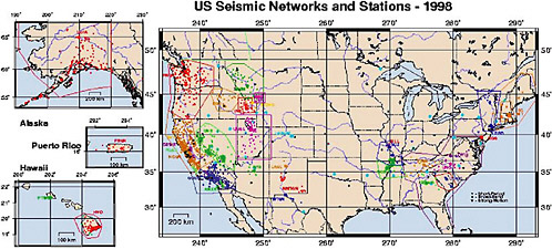
Seismic monitoring activities in the United States today are based on a patchwork of regional seismic networks (see Figure 1.1) that use varying seismic instruments, often with limited fidelity and dynamic range. These networks are an evolutionary product of university-based networks that were installed in the early part of the twentieth century primarily to record the size and temporal-spatial distribution of major earthquakes. The Worldwide Standardized Seismograph Network (WWSSN) was established in the 1960s as a global network for monitoring nuclear explosions. During this same time period, regional seismic networks designed to monitor smaller earthquakes were established across the country. The principal factor driving the establishment of many of these regional networks was the need to characterize the potential seismic risk to critical facilities, especially nuclear power plants. During this time, the U.S. Nuclear Regulatory Commission (USNRC) funded the installation and operation of hundreds of seismic stations across the continent with the primary mission of monitoring the nation’s seismicity (rather than recording strong ground motion). However, the USNRC abandoned these networks in the 1980s when it concluded that sufficient information had been gathered for plant design. The National Research Council (NRC) conducted a study in 1990 to assess the need for these networks and concluded that regional seismic networks were an essential component of the nation’s strategy to decrease losses from earthquakes (NRC, 1990). That study proposed that the USGS should assume at least partial responsibility for a National Seismic System (NSS) to integrate data from the many regional networks. Unfortunately, funding for an upgrade of the NSS was extremely limited and most regional networks still continue to operate with equipment that is 20 or more years old.
At the heart of the nation’s seismic monitoring capability is the U.S. National Seismic Network (USNSN), a “backbone” of seismic monitoring stations—operated by the U.S. Geological Survey (USGS)—that provides uniform coverage across the country and integrates data from its own stations and the more than 2,500 seismograph stations in regional networks. These regional networks provide information about earthquakes to the USGS National Earthquake Information Center (NEIC) in Colorado, which serves as a national point of contact for distributing earthquake information.
In 1997, the passage of Public Law 105-47 directed the USGS to assess the status of regional seismic monitoring networks in the United States, emphasizing the need for updated network infrastructure as well as expanded strong motion capabilities for urban area engineering purposes. In response, the USGS presented an assessment of the status, needs, and associated costs of seismic monitoring, proposing that an Advanced National Seismic System (ANSS) (USGS, 1999) would be required to meet the nation’s needs for seismic monitoring (Box 1.2). This proposal included a comprehensive strategy to update and coordinate the nation’s regional seismic networks to provide (1) public alerts within a few seconds of imminent strong earthquake shaking; (2) rapid assessments of the distribution and severity of earthquake shaking for use in emergency response; (3) warnings of possible tsunamis from offshore earthquakes; (4) warnings of volcanic eruptions; (5) information for correctly characterizing earthquake hazards and improving building codes; and (6) critically needed data about the response of buildings and structures during earthquakes for safe and cost-effective design, engineering, and construction practices in earthquake-prone regions (USGS, 1999). The distribution of ANSS seismic stations proposed for the nation’s urban centers (Table 1.1) was based on relative seismic risk—a function of the population potentially exposed to strong ground shaking and the potential severity of that shaking.
Existing Weak Motion Monitoring Networks
There are approximately 1,700 stations5 in the United States equipped with conventional weak motion seismic instruments (Figure 1.1) (CNSS, 1998). These stations are distributed among approximately two dozen regional seismic networks that are coordinated through the ANSS. Most of these networks are operated by universities or university-state partnerships, with partial funding from the USGS. Most of the stations (>1,500) are equipped with short-period seismometers, and the remainder with high-quality, broad band instruments. Most of these short-period instruments record only the vertical component of motion, and not the horizontal components which usually constitute the most damaging ground motions and form the basis for building codes. In addition, the instrument responses of most of the short-period instruments are poorly known. Accordingly, the short-period instruments are useful mainly for locating earthquakes and estimating their magnitudes and do not provide the ground motion recordings that are directly of use for earthquake engineering.
|
BOX 1.2 The proposal for an Advanced National Seismic System described in USGS Circular 1188 (USGS, 1999) presents a plan for the modernization, expansion, and integration of the nation’s earthquake monitoring networks. This proposal describes the capital investment (totaling $171.3 million in 1999 dollars; $189 million in 2003 dollars) and annual operating and maintenance costs required for this multicomponent physical and informational infrastructure (the following figures are adjusted to 2003 dollars):
Small funding appropriations over several years have enabled the initial steps toward achieving the ANSS vision. The ANSS has been established by incorporating existing earthquake monitoring capabilities, involving collaborative arrangements with existing regional monitoring networks as well as installation of small numbers of modern digital seismographs and initial upgrades to NEIC capabilities. However, until significantly increased funding is available, the existing ANSS will be capable of achieving only a small fraction of the potential benefits described in this report. As well as considering potential benefits that would result from implementation of the USGS vision for improved seismic monitoring proposed for the ANSS in both its present (embryonic) and proposed forms, the committee also considered the potential benefits that would result from an “ideal” level of seismic monitoring where critical and economically significant structures and lifelines in all urban regions of the country are monitored. |
TABLE 1.1 Number and Distribution of Seismic Stations Proposed for the ANSS
|
Urban Area |
Earthquake Hazard (%ga) |
Population (millions) |
Relative Risk Factorb |
No. of Urban Stations |
|
Los Angeles, CA |
88 |
15.4 |
5.1221 |
1,300 |
|
San Francisco, CA |
99 |
6.5 |
2.4322 |
1,000 |
|
Seattle, WA |
34 |
3.3 |
0.4241 |
600 |
|
Salt Lake City, UT |
29 |
1.2 |
0.1315 |
400 |
|
Anchorage, AK |
35 |
0.3 |
0.0397 |
300 |
|
San Diego, CA |
25 |
2.6 |
0.2457 |
300 |
|
Portland, OR |
19 |
2.0 |
0.1436 |
300 |
|
Reno, NV |
33 |
0.3 |
0.0374 |
200 |
|
Memphis, TN |
14 |
1.1 |
0.0582 |
200 |
|
St. Louis, MO |
10 |
2.5 |
0.0945 |
200 |
|
Santa Barbara, CA |
52 |
0.4 |
0.0786 |
100 |
|
Salinas, CA |
43 |
0.4 |
0.0650 |
100 |
|
San Juan, PR |
30 |
1.0 |
0.1134 |
150 |
|
Provo-Orem, UT |
19 |
0.3 |
0.0215 |
100 |
|
Sacramento, CA |
17 |
1.6 |
0.1028 |
100 |
|
Las Vegas, NV |
12 |
1.1 |
0.0499 |
100 |
|
Chattanooga-Knoxville, TN |
10 |
1.1 |
0.0416 |
100 |
|
Stockton-Lodi, CA |
18 |
0.5 |
0.0340 |
60 |
|
Fresno, CA |
12 |
0.8 |
0.0363 |
60 |
|
Charleston, SC |
18 |
0.5 |
0.0340 |
60 |
|
Albuquerque, NM |
11 |
0.7 |
0.0291 |
50 |
|
Eugene-Springfield, OR |
14 |
0.3 |
0.0159 |
50 |
|
Evansville, IN |
11 |
0.3 |
0.0125 |
40 |
|
Boise, ID |
7 |
0.4 |
0.0106 |
50 |
|
New York, NY |
6 |
18.1 |
0.4105 |
40 |
|
Boston, MA |
5 |
5.8 |
0.1096 |
40 |
|
Total |
|
|
|
6,000 |
|
aHazard is expressed in terms of the severity of ground shaking—in percent of gravity—that has a 10% chance of being exceeded in the next 50 years. bThe relative risk factor is a function of the hazard factor and the population at risk; note that only a few stations are proposed for areas with very high populations but only low hazard. SOURCE: USGS (1999). |
||||
Existing Strong Motion Monitoring Networks
There are approximately 1,400 strong motion recorders in the nation (Figure 1.2) (CNSS, 1998). Of these sites, approximately 200 are operated by regional seismic networks and the remainder are operated either by organizations that specialize in strong motion recordings (e.g., the California Strong Motion Instrumentation Program) or by private facilities (e.g., utility company monitoring of nuclear power plants, as required by the USNRC). The Consortium of Organizations for Strong-Motion
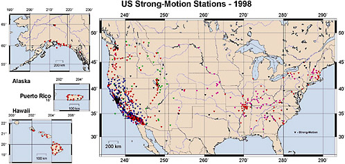
Observation Systems (COSMOS)6 is an organization that represents most agencies and entities that are recording strong motion data and maintains a virtual data center that makes records easily accessible.
The deployment of additional strong motion seismic monitoring stations in urban regions has the potential to provide greatly improved descriptions of seismic hazard and risk. Even in the most densely instrumented urban regions, current strong motion recording stations at ground locations are too sparse to permit the compilation of reliable seismic zonation maps based on recorded earthquake data. Such maps have the potential to identify those parts of urban regions (“hot spots”) that are especially prone to strong ground shaking during earthquakes, providing a basis for the prioritization of mitigation activities. Similarly, because of the small number of strong motion stations located in structures, few owners will have the benefit of a “proof test”—knowing the relationship between the level of ground shaking experienced by the structure and the level of ground motion for which it was designed. An ideal level of seismic monitoring—the ultimate extension of the present ANSS proposal—would permit the identification of ground shaking hot spots and provide for the proof-testing of all critical and economically significant structures and lifelines in all seismically active urban regions of the country.
EarthScope
In 2003, the National Science Foundation (NSF) provided initial funding for a major research equipment initiative called EarthScope (EFEC, 2003). This decade-long, research-oriented initiative seeks to understand the continental dynamics and structure of North America by integrating data from geology, seismology, geodesy, and remote-sensing observational facilities. EarthScope scientists have specifically identified the earthquake process as a primary scientific target, seeking to develop predictive models by unraveling the dynamic processes along faults (EarthScope, 2002). At present, EarthScope has three components:
-
A deep borehole observatory that is designed to measure physical conditions deep on a plate boundary. The San Andreas Fault Observatory at Depth (SAFOD) will be a 4-km deep hole drilled to intersect the San Andreas Fault (the plate boundary between North America and the Pacific).
-
A geodetic observatory designed to study the three-dimensional strain and deformation of the North American continent. The Plate Bound
-
ary Observatory (PBO) will consist of arrays of Global Positioning System (GPS) receivers, strainmeters, and seismometers.
-
A continental-scale seismic observatory (USArray) designed to provide a foundation for integrated studies of the continental lithosphere (the upper 150 km of the earth) and deeper mantle structure over a wide range of scales.
USArray is a research network that initially will provide results that complement the ANSS, and a component of this network will ultimately become part of the ANSS. USArray comprises:
-
a transportable array of 400 portable three-component, broadband seismometers deployed on a uniform grid that will systematically cover the United States (with the exception of Hawaii);
-
a permanent array of 40 high-quality, three-component seismic stations (the “Backbone Network”) that will remain in place and become part of ANSS; and
-
a flexible array of approximately 2,400 seismometers (a mix of broadband, short-period, and high-frequency sensors) that will be deployed within the footprint of the larger transportable array to record data for specific geologic targets.
USArray data will be used to image the details of the earth’s structure beneath the nation. Stations will be deployed in many regions where there presently is only sparse coverage. However, the portable component of the USArray—which will provide the most dense station coverage—will be deployed at any one site only for approximately 18 months. Although there is likely to be serendipitous discovery in this short period of time, it will not fulfill the need for long-term monitoring. The permanent component of USArray—approximately 40 very high quality seismic stations—will become part of ANSS-USNSN and thus can be considered a leveraged contribution to the USGS system. The principal goal of ANSS is earthquake monitoring, an evolutionary and ongoing activity with a primary focus on continuously improved quantification of earthquake hazards. USArray, on the other hand, is a one-time comprehensive examination of the deep structure of the crust and upper mantle, primarily for research purposes. Thus ANSS is quite distinct from—yet complementary to—the USArray effort.
The Plate Boundary Observatory component of EarthScope is a geodetic observatory designed to study the three-dimensional strain field resulting from deformation across the active boundary zone between the Pacific and North American plates in the western United States. The PBO backbone will consist of 100 new and 20 existing GPS receivers that will
provide a long-wavelength, long-period synoptic view of the entire plate boundary zone. An additional 16 GPS receivers will be located at USArray-supported stations in the USNSN. The backbone will cover western North America and Alaska at a receiver spacing of 200 km and eastern North America at a receiver spacing of 500 km. With the deployment of the PBO component of EarthScope, the USGS regional networks will take on renewed importance. A major focus of PBO’s clusters of geodetic instruments will be the observation of transient deformation in the seismically and volcanically active areas of the western United States. In addition to surface observations of deformation, it is important to observe proxies for subsurface deformation—such as seismicity—through the use of regional networks. The areas covered by regional networks are essentially the same as those that will be covered by the PBO GPS-strainmeter deployments. In fact, this overlap is already being exploited, with GPS receivers planned to be co-located with regional network seismographic stations where feasible. In addition, PBO will be deploying high-bandwidth, three-component seismometers in each of the 175 borehole strainmeter sites. Consequently, PBO will be operating a 175-station regional borehole seismic monitoring network that will complement the existing regional networks operated by the USGS.
As both seismic monitoring programs—ANSS and the monitoring component of EarthScope—are implemented, there is an evolving relationship between the programs. One example is the location of PBO facilities within regional seismic networks to allow sharing of telemetry and maintenance costs. One of the ultimate goals of EarthScope is to understand the driving forces and consequences of plate tectonics to provide a better understanding of earthquake science—a goal shared with earthquake monitoring.
USES OF SEISMIC MONITORING
The transition path from data outputs produced by seismic monitoring instruments to information for decision-makers (e.g., emergency managers, earthquake engineers) requires analysis steps that differ depending on the type of seismic monitoring data and the area of decision. The different pathways are summarized in Figure 1.3 and described in more detail below.
Seismic monitoring networks provide the basis for hazard analysis and quantification, and the density of network coverage and instrument type determines how much will be learned from each damaging earthquake. Recent earthquakes have shown that existing seismic monitoring networks are too sparse to provide the essential information required to understand what happened during these earthquakes—the location and
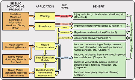
FIGURE 1.3 Flowchart summarizing the information path from seismic monitoring data outputs, through a range of applications, to ultimately provide the broad range of benefits described in this report.
nature of ground motion—and in particular what can be done to improve future construction and reduce vulnerability. This is true to some extent even in the three counties affected most by the 1994 Northridge earthquake,7 where seismic monitoring was significantly upgraded following the earthquake. The potential economic benefits of improved seismic monitoring for engineering purposes are discussed in Chapter 6.
HAZUS—nationally applicable loss estimation software developed by the National Institute for Building Sciences (NIBS) for the Federal Emergency Management Agency (FEMA) (see Chapter 5)—combines a range of hazard information provided by the USGS (e.g., national maps of earthquake shaking hazard, real-time maps of ground shaking intensity following actual earthquakes) with engineering-based models of urban areas to estimate earthquake risk at both the national (FEMA, 2001a) and the regional or local scale.8 A combination of improved earthquake loss estimation tools and improvements in data processing and communications
|
7 |
Los Angeles, Orange, and Ventura Counties in southern California. |
|
8 |
See http://fema.gov/hazus/cs_main.shtml for case studies illustrating how HAZUS is being used to support hazard mitigation planning. |
|
BOX 1.3 At the time of the September 21, 1999, Mw 7.6 earthquake, Taiwan was in the midst of a seismic network upgrade project initiated in 1997 by the Central Weather Bureau (CWB). One component of this network is a Rapid Earthquake Information Release System based on 61 real-time digital accelerographs that are connected via telemetry to the CWB Seismology Center. This system, which was in place and operating at the time of the earthquake, provided notification of the magnitude, location, strong motion data, and an instrumental intensity map to 247 organizations nationwide within 2 minutes of the earthquake through paging, fax, and the Internet. These organizations included all fire and police agencies at the local, regional, and national government levels; ministries with emergency response and recovery functions; dam and nuclear power plant managers; scientists; and the news media. Receipt of information from the seismic network played a key role in early situation assessment at the national government level. Information received in real time by high-level officials in the Ministry of the Interior facilitated the mobilization of emergency response resources at all levels of government by 3:30 a.m., less than 2 hours after the earthquake occurred (Uzarski and Arnold, 2001). In contrast, it required 45 minutes after the 1994 Northridge earthquake to transmit the magnitude and location of the earthquake to emergency response agencies and nearly a week to generate a shaking intensity map. Although the seismic network in urban California can now provide earthquake information and mapping in real time, other parts of the nation—despite moderate to high seismic risk—do not currently have access to accurate and reliable real-time information products for a major earthquake. |
during the last decade have enabled the creation and internet distribution of vital information within tens of minutes after an earthquake event. In the critical short-term period immediately after an earthquake, seismic monitoring data are used to create an initial “snapshot” of the emergency to initiate and prioritize appropriate response activities (as occurred following the 1999 Mw 7.6 Chi-Chi earthquake in Taiwan [Box 1.3]9 and
the 2001 Mw 6.8 Nisqually, Washington earthquake). Geographic Information System (GIS) based ShakeMaps, an internet-based real-time map information product generated by the USGS, show the location of strong ground shaking within minutes to tens of minutes after an event. The economic benefits for emergency response derived from the products of improved seismic monitoring, such as ShakeMaps, are discussed in more detail in Chapter 7.
Aftershock advisories in the days to weeks following significant earthquakes provide input to scheduling of operations that may be adversely affected by aftershocks, as well as real-time warnings to rescue crews during response activities. Tsunami watch and warning bulletins issued by the Pacific Tsunami Warning Center for submarine earthquakes and volcanic ash advisories for erupting volcanoes issued by the Alaska Volcano Observatory are additional examples of the benefits that seismic monitoring networks provide in the short term.
In the long term, data from seismograph networks and monitoring arrays in structures (buildings, roads, bridges, pipelines, utilities, etc.) are used to advance the fundamental scientific and engineering understanding of earthquake occurrence and effects. In late 1999, NSF launched the George E. Brown, Jr., Network for Earthquake Engineering Simulation (NEES) to accelerate the development of new seismic mitigation technologies. NEES is a large-scale, fully integrated, national resource that is in the process of shifting the emphasis of earthquake engineering research from its current reliance on physical testing to integrated experimentation, computation theory, databases, and model-based simulation. It involves 15 major earthquake engineering experimental research equipment installations networked through a high-performance Internet. Working in collaboration with the broader earthquake engineering community, NEES is expected to use advanced equipment and simulation capabilities to test and validate complex and comprehensive analytical and computer numerical models. The success of multi-institutional efforts such as the NEES initiative depends on the data recorded by high-quality networks. Strong motion recordings in the free field (away from structures) provide realistic input for engineering simulations and studies of structural response of buildings, bridges, and other facilities. Strong motion recordings made inside buildings, bridges, and other critical infrastructure provide information about structural response and damage. These data can be compared with the design parameters to evaluate possible damage states immediately after an earthquake and prioritize inspection and repair activities. In the longer term, these data are essential for developing new generations of earthquake-resistant building systems.
COSTS OF SEISMIC MONITORING
Any compilation of the economic benefits of improved seismic monitoring, as a component of a benefit-cost analysis (BCA; see Chapter 3), must also include an evaluation of the costs to the nation of improved seismic monitoring. These costs include the following:
-
the costs of maintaining and operating the nation’s existing seismic monitoring networks, including present federal contributions to the ANSS as well as nonfederal contributions to the plethora of state, university, and private networks now included within the ANSS;
-
the costs of expanding the nation’s monitoring, particularly with the deployment of modern digital seismographs as part of the full ANSS proposal, and the operational and maintenance costs after the instrumentation is in place; and
-
a component of the seismic monitoring costs of EarthScope, representing those costs associated with the permanent “backbone” network of seismographic stations and the PBO regional borehole seismic network.
Financial support for the present system of seismic monitoring networks is complex. In FY 2003, the USGS provided $4.8 million to support regional networks. The network operators also receive support from state agencies and universities in the form of direct dollars and in services (e.g., technical support); consequently, it has been difficult to determine the total costs of operating the nation’s existing seismic monitoring networks. A recent estimate by USGS of the operating costs for the Pacific Northwest Seismograph Network indicates that the USGS provided approximately 60 percent of operational funding for this network. In response to a request by the committee, the USGS compiled an estimate of total earthquake monitoring expenditure for FY 2004, concluding that the total of approximately $32 million ($31 million in 2003 dollars) was distributed among federal and state agencies as follows (Figure 1.4):
-
USGS ($19.0 million)—encompassing the Earthquake Hazard Program ($14.6 million) and existing ANSS instrumentation ($4.4 million)
-
State of California ($8.1 million)—encompassing the California Strong-Motion Instrumentation Program (CSMIP), California Integrated Seismic Network (CISN), and dam and aqueduct monitoring
-
Other federal agencies ($2.3 million)—including the National Oceanic and Atmospheric Administration’s (NOAA’s) tsunami monitoring program and the Bureau of Reclamation, U.S. Army Corps of Engineers, Department of Energy (DOE), and General Services Administration monitoring programs for structure instrumentation
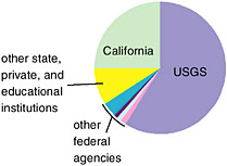
FIGURE 1.4 Distribution of FY 2004 federal spending for earthquake monitoring. SOURCE: Unpublished data provided by USGS (August 2004).
-
A very approximate estimate of $2.9 million spent by other state and private industry monitoring programs, as well as educational institutions
These estimates do not include spending on the monitoring of volcanic seismicity (estimated to be less than $4 million); military and DOE monitoring related primarily to nuclear test verification; research monitoring (e.g., monitoring components of the EarthScope initiative); earthquake monitoring required for regulatory compliance (e.g., dams, nuclear power facilities); and “in-kind” contributions (e.g., the provision of facility space for instrumentation).
The costs to deploy, operate, and maintain ANSS instrumentation are presented in USGS (1999), amounting to $171.3 million ($189.2 million in 2003 dollars), with $47 million ($51.9 million) needed annually for operations. Congress authorized the ANSS in 2000, and the USGS now considers all of its existing seismic monitoring activities (except in situ volcano monitoring) to be components of the ANSS. Annual appropriations to begin implementation of the ANSS were $3.9 million in FY 2002 and FY 2003, increasing to $4.4 million in FY 2004 and $5.25 million in FY 2005.
Because of the short (18-month) deployment period for the research-oriented USArray transportable seismic system, it is not practical to consider the deployment, operational, and maintenance costs for these instruments as part of this analysis. However, the costs for the permanent USArray stations that will ultimately become part of the USNSN backbone—estimated to be $3.5 million for purchase and $1.1 million for operations and maintenance—are seismic monitoring costs that must be considered in a BCA. Purchase and installation costs for the high-bandwidth seismometers that will be emplaced at 175 borehole strainmeter sites as part of the PBO component of EarthScope are estimated at $1.4 million
(UNAVCO, 2005). The annual operation and maintenance expenses for this seismometer network have not yet been determined.
In summary, the cost to the nation of improved seismic monitoring has three components:
-
Annual costs for operating and maintaining existing seismic monitoring networks of approximately $31 million (recognizing that this is augmented by unquantified local support)
-
A total of $189 million for expansion and modernization of strong motion capabilities to establish the full ANSS, together with annual operating and maintenance costs of $52 million
-
A total of $4.9 million for hardware costs for the permanent USArray and PBO seismic monitoring components of EarthScope, together with annual operations and maintenance costs that have not yet been finalized
EXTENT OF LOSSES FROM EARTHQUAKES
Projects that are designed to reduce losses from natural or other disasters, such as improved seismic monitoring, are expected to provide benefits in the form of avoided losses or avoided costs. This means that the cost of such natural disasters—without mitigation measures such as improved seismic monitoring in place—must first be identified to establish a benchmark. This requires that for any particular area, the probability distribution of possible earthquake disasters and the consequent expected dollar losses must be calculated, necessitating a series of difficult estimates based on geologic and earthquake engineering projections. Although these are complex calculations, they must precede any complete estimation of project benefits. An assessment of the economic impact of improved seismic monitoring requires the identification of how the estimated benchmark losses would be reduced. This latter calculation would be undertaken for plausible increments of improved monitoring, if these can be identified.
Earthquake losses have been studied extensively by the NRC and others (e.g., see NRC, 1989, 1992, 2003b). In general, losses or costs associated with earthquakes fall into five major categories—direct physical damage, induced physical damage, human impacts, costs of response and recovery, and business interruption and other economic losses.
Direct Physical Damage
Direct physical damage is typically the largest contributor to overall losses and includes damage to buildings and infrastructure. In theory, this category of loss is the simplest to quantify, although in practice,
detailed data are not often comprehensively compiled. Further, data may exist from a variety of sources. For example, the cost to repair a given structure may often be borne by more than one party (e.g., building owners, insurers). Nevertheless, the aggregate cost of direct physical damage has been estimated or measured in most recent earthquake events in the United States, as well as for some major historical events in other parts of the world (e.g., Tables 1.2 and 1.3).
Direct building damage may include structural damage, nonstructural damage, and damage to building contents and inventory. Other direct costs associated with loss of building function until it is repaired include relocation costs, lost rental income, lost wages, and lost income (NIBS/FEMA, 2002).
Infrastructure losses include damage to the transportation infrastructure (highways, roadways, airports, ports, light or heavy rail, buses, and ferries), as well as damage to utilities (electric power, water, wastewater, communications, oil and natural gas). In addition to the cost to repair such damage, the utilities may incur revenue losses associated with outages, costs associated with procuring alternate supplies, and in some
TABLE 1.2 Estimated Direct Losses in Significant U.S. Earthquakes
TABLE 1.3 Estimated Direct Losses in Significant Worldwide Earthquakes
|
Earthquake |
Fatalities |
Economic Losses ($ million) |
Insured Losses ($ million) |
|
1923 Kanto, Japan |
142,800 |
2,800 [30,129] |
590 [6,349] |
|
1976 Tangshan, China |
290,000 |
5,600 [18,107] |
|
|
1995 Kobe, Japan |
6,348 |
>100,000 [>120,735] |
3,000 [3,622] |
|
1999 Izmit, Turkey |
>17,000 |
>13,000 [>14,358] |
1,000 [1,104] |
|
1999 Chi-Chi Taiwan |
2,400 |
>11,000 [>12,149] |
>850 [>939] |
|
SOURCE: Data from Munich Re Group (2000). |
|||
cases, regulatory fines. Indirect costs may also be associated with infrastructure damage, such as the economic cost of traffic delays or lost economic output due to closure in the face of utility outage.
In addition to potentially significant economic losses due to physical damage, rapid restoration of electric power systems is vital for both response and recovery. Direct costs to electric power utilities for the repair and replacement of earthquake-damaged equipment have been estimated to be ~$75 million for the 1989 Loma Prieta (Mw 6.9) and $183 million for the 1994 Northridge (Mw 6.7) earthquakes (Schiff, 1999). Because of the rapid restoration of electrical service and customer “resilience,” such as the ability to make up lost production at a later date, these direct capital-related costs were much greater than the direct and indirect business interruption impacts to consumers (Rose and Lim, 2002; see Box 1.4).
|
BOX 1.4 The results of two in-depth studies following the Northridge Earthquake shed some light on direct and indirect business interruption losses from electricity lifeline disruptions. Rose and Lim (2002) estimated the direct business interruption loss for the Los Angeles Department of Water and Power (LADWP) service territory as $109 million, including lost revenue to LADWP (although this excluded equipment damage to LADWP and its customers). This direct operating loss to the utility and its customers is roughly 50 percent of the estimated direct property damage to the LADWP system. Most businesses are, however, highly resilient to short-term power disruption. Resilience factors include the ability to make up lost production at a later date (very prominent in non-service industries); time-of-day usage (the majority of the total outage of electricity took place before 9:00 a.m.); the fact that some aspects of production do not require electricity (most notably agriculture, construction, and transportation); electricity conservation; use of backup generators; and use of other types of energy or other inputs. Incorporating only the first three of these factors on a sector-by-sector basis into their model yielded a lower-bound estimate of only $5.6 million in direct business interruption losses, or about 0.4 percent of one day’s production in Los Angeles County. Tierney (1997a, 1997b) conducted a questionnaire survey and follow-up personal interviews of more than 1,000 businesses (responding) in the cities of Los Angeles and Santa Monica following the Northridge earthquake. Using Tierney’s data on reasons for closing, duration of closure, |
Larger earthquakes that impact larger areas, or occur closer to urban areas, will produce more extensive damage that can overwhelm the electric system redundancies and customer resilience that worked in the past for smaller earthquakes. As a result, unacceptable equipment losses, direct and indirect losses borne by customers, and lengthy disruption of service to the community are likely. The Applied Technology Council estimated that total indirect business losses from either a Mw 7.5 earthquake on the Hayward fault or an Mw 8.0 earthquake on the southern San Andreas Fault at Fort Tejon could be ten times greater than the direct losses experienced by utilities (ATC, 1991). Post-earthquake functioning of utility systems, particularly electric power service, is viewed by emergency responders and society in general as absolutely vital for rapid response
|
and recovery activities following a major urban earthquake. Faster post-and stated dollar losses sustained to businesses due to closure, Rose and Lim extrapolated the results to an estimate of $21.6 million of direct business interruption losses for Los Angeles County. Tierney’s estimates are higher because she considered customers beyond the LADWP service area, her sample favored high-intensity impact areas and because Rose and Lim’s simulation model may have overestimated resilience (most likely the ability to “recapture” lost production) in some sectors. Rose and Lim also used an input-output model to determine indirect business interruption losses from the electricity outage. Noting that the outage was of very short duration and that inventory supplies were probably adequate to cover the lack of inputs of various goods and services that were not provided by the direct production decreases, the authors confined their estimate of indirect losses to “bottleneck” effects (see also Cochrane, 1997). The economy-wide multiplier in their analysis was 1.3 (meaning that indirect business interruption was 30 percent of direct business interruption), which resulted in an upper-bound estimate of total business interruption losses (now including the indirect component) of $142.1 million and a lower-bound estimate of $7.3 million. Note that both the Rose and Lim and the Tierney estimates are much lower than estimates in a more recent study of electricity outages in the Los Angeles area. For example, the URS TriNet report (URS Group, 2001) estimated losses assuming a complete loss of electricity for a 24-hour period for the three counties of Los Angeles, Orange, and Ventura, and excluding nearly all resilience factors. Hence, it arrived at an estimate of $2.5 billion. The broad geographic coverage of the URS study would be relevant to only the most serious earthquake possible or if a system failure were triggered analogous to that of the Northeast electricity outage of the summer of 2003. |
earthquake restoration of utilities enables a timely resumption of normal business operations. Disruptions of utility service and transportation networks due to earthquakes not only impact public safety and a community’s ability to respond immediately after the event, but also affect the longer-term recovery. While the direct costs for the repair and replacement of earthquake-damaged lifeline facilities have been significant, there have also been very high indirect costs due to impaired infrastructure. One study of the 1994 Northridge earthquake included estimates of $6.5 billion of business interruption costs, of which $1.5 billion was ascribed to transportation network disruptions (Gordon et al., 1998). These costs were not captured in widely circulated structure replacement losses. The study also found that these losses could have been much higher were it not for the substantial redundancies in the road and highway network in the area.
A recent study on the effects of a large New Madrid earthquake suggests that the direct and indirect economic losses due to extended power disruption could be as high as $3 billion (Shinozuka et al., 1998). At the time of the study, very little empirical evidence was available to suggest that such a loss was even possible. However, in August 2003, a major power outage occurred over a large portion of the northeastern United States and Ontario, Canada. This event affected eight states, approximately 50 million people, and resulted in an estimated $4 billion to $10 billion of losses in the United States (ELCON, 2004). Although not earthquake related, the consequences are similar and demonstrate the effect that cascading failures can have on a regionally distributed power grid.
Induced Physical Damage
Earthquake shaking can cause damage to engineered structures and equipment, with the failure in turn resulting in a secondary or induced damage effect. Examples of induced physical damage include fire damage associated with post-earthquake fire or conflagration, potential flooding impacts associated with dam failure, hazardous materials release caused by building or equipment failure, and other environmental impacts. Induced physical damage impacts can be quite large, in some cases rivaling or even exceeding the cost of direct physical damage (e.g., fire losses in the 1906 San Francisco earthquake).
Human Impacts
The primary human impacts of earthquake consist of injury and death (together referred to as “casualties”), but also include displacement—often requiring long-term shelter—and quality-of-life issues such as mental
health impacts or unemployment. Typically, casualty estimates are reported after most earthquakes, although the categories used and their definitions vary from event to event. Casualties resulting from the 1994 Northridge earthquake have been extensively studied (e.g., Seligson and Shoaf, 2003), and these are summarized in Figure 1.5. It is important to note that although the number of injuries and deaths is usually reported, the economic costs associated with these injuries and deaths often are not. Some of these data may exist in insurance files (e.g., health insurance, worker’s compensation insurance), but historically the data have not been made publicly available. Recent estimates of economic costs associated with casualties in the Northridge earthquake have been as high as $2.2 billion (Porter et al., in press).
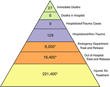
FIGURE 1.5 Injuries and deaths in the 1994 Northridge earthquake. Figures marked with asterisks indicate numbers of households; other numbers refer to individuals. SOURCE: Copyright 2003 from Human Impacts of Earthquakes by H.A. Seligson and K.I. Shoaf. Reproduced by permission of Routledge/Taylor & Francis Group, LLC.
Emergency Response and Recovery Costs
The cost of responding to an earthquake disaster can be significant, and in the United States such costs are often shared among local, state, and federal authorities. Emergency response costs include a wide variety of services:
-
first-responder costs (personnel costs, including overtime), encompassing search and rescue, firefighting, and HAZMAT response; emergency medical services; police security at damage sites; and so forth; and
-
service costs related to building damage, including post-earthquake building safety inspections (e.g., safety-tagging), emergency shoring and demolition, and debris removal.
A variety of recovery programs exist to facilitate individual, business, and community recovery. Such programs include loans (e.g., both privately funded and Small Business Administration loans), recoveries from private insurance policies, and grants (e.g., FEMA’s Disaster Housing Assistance, Individual and Family Grants, and Hazard Mitigation Grants).
Business Interruption and Other Economic Losses
For many years, direct losses in the form of property damage comprised the measurement of economic consequences of natural disasters. However, during the past decade there has been a heightened awareness that other types of losses that may result from physical damage as well as other causes—such as direct and indirect business interruption, and environmental and social impacts—must also be considered (Mileti, 1999; NRC, 1999; Heinz Center, 2000; Ganderton, 2005). For example, direct business interruption can result from building or equipment damage, utility outage, lack of employees (due to injury, displacement, or transportation interruption), or supplier interruption. If enough businesses suffer interruptions, there can be a multiplier—or ripple—effect, indirectly impacting other economic sectors that may not have suffered direct damage of their own. This would include cancellation of orders by firms damaged or cut off from their transportation lifelines and the inability of other firms to sustain production because suppliers could not deliver critical inputs.
Indirect or secondary losses are those incurred in the days, weeks, or months following a disaster and include losses due to business interruption caused by infrastructure disruption (e.g., electric power, gas, water), reduction of critical services to residents in hazard-prone areas, and psy-
chological trauma (Heinz Center, 2000). Indirect losses are difficult to document and are rarely measured after earthquakes, although methods exist to estimate potential impacts in actual and postulated events.
The 1994 Northridge earthquake is the best-documented earthquake event in U.S. history, providing an illustration of the magnitude of both direct and indirect costs. Table 1.4 provides a breakdown of available direct cost data for this earthquake, showing a total tabulated cost of $24 billion. In addition, data were not available for a number of significant costs—including the cost of insurance deductibles or uninsured losses—and these untabulated costs have been estimated at $20 billion.
TABLE 1.4 Direct Costs Associated with the 1994 Northridge Earthquake
|
Type of Cost |
Total Estimated Cost ($ billion) |
|
|
Buildings and Infrastructure |
||
|
Privately insured residential claims |
$8.4a |
|
|
|
Structures (coverage A) = $5.6 billion |
|
|
|
Appurtenant structures (coverage B) = $0.6 billion |
|
|
|
Contents (coverage C) = $2.0 billion |
|
|
|
Loss of Use (coverage D) = $0.2 billion |
|
|
Privately insured business claims (including a few public agencies that had insurance) |
$4.1 |
|
|
Repair of transportation structures and roadways |
$0.327 |
|
|
Utilities |
$0.3 |
|
|
Public assistanceb |
$4.5 |
|
|
Emergency Response and Recovery |
||
|
American Red Cross |
$0.0364 |
|
|
Salvation Army |
$0.001 |
|
|
Individual or family grant programs (including state supplemental grant and mental health) |
$0.25 |
|
|
Hazard mitigation |
$0.92 |
|
|
Small business administration |
$4.03 |
|
|
Disaster housing and mortgage assistance |
$1.2 |
|
|
California Employment Development Deptartment |
$0.041 |
|
|
State Board of Control |
$0.055 |
|
|
Subtotal |
||
|
Other costs (estimated) |
$20 |
|
|
(insurance deductibles, uninsured losses) |
||
|
Estimated total cost |
$44 |
|
|
aA more recent estimate of insured losses is $15.3 billion (Munich Re Group, 2000). bPublic assistance typically funds repairs to damaged publicly owned buildings and infrastructure. SOURCE: Eguchi et al. (1998). |
||
Consequently, the total direct cost of this earthquake was estimated to be as much as $44 billion (Eguchi et al., 1998). Indirect economic losses associated with transportation interruptions in this earthquake have been estimated to be an additional $1.5 billion (Gordon et al., 1998); no estimates have been published for other indirect costs.
Estimates of Future Earthquake Losses
Although recent worldwide earthquake losses exceed those experienced by the United States (compare Tables 1.2 and 1.3), it is reasonable to expect significant damaging earthquakes in the United States in the future—large earthquakes are inevitable in California, the Pacific Northwest, and other seismically active regions of the country. Further, population densities are increasing in our complex urban environments, and replacement of the nation’s vulnerable building stock and infrastructure occurs very slowly. All of these factors contribute to an increasing risk of significant damage and loss in future earthquakes. FEMA (2001a) estimated expected annual buildings and building-related earthquake losses in the United States as $4.4 billion per year (see Figure 1.6), consisting of $3.5 billion per year in capital losses (building repair, lost contents and inventory) and $0.9 billion per year in income losses related to building damage (e.g., rental income losses, wage losses, business interruption). Using a Consumer Price Index (CPI) adjustment,10 this expected annual loss total is $5.6 billion in 2003 dollars. In fact, EERI (2003) estimated that a single significant earthquake could result in losses greater than $100 billion. Although the bulk of annualized losses occur in California and on the West Coast, a relative earthquake risk assessment, as measured by the annualized earthquake loss ratio (losses relative to replacement value; see Figure 1.7), highlights other high-risk areas such as the central United States and Charleston, South Carolina.
Box 1.5 provides estimates as to how much earthquake losses from the 1994 Northridge earthquake could have been reduced had all of the buildings in the affected area been designed to the current seismic code. It also provides estimates of how a comprehensive seismic rehabilitation program could reduce economic and social losses from magnitude 7.0 scenario earthquakes on the Newport-Inglewood Fault in southern California and the Hayward Fault in northern California. These examples demonstrate the effectiveness of previous NEHRP work, including the use of information from seismic monitoring, in enhancing the effectiveness of building codes.
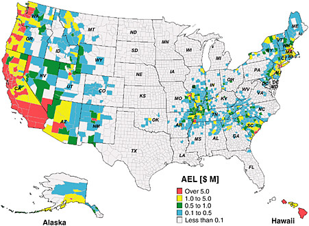
FIGURE 1.6 Map showing average annual buildings and building-related earthquake losses. Based on 1990 census data, this annual earthquake loss (AEL) was estimated to be $4.4 billion in 1994 dollars, equivalent to $5.6 billion in 2003 dollars. SOURCE: FEMA (2001a).
COMMITTEE CHARGE AND SCOPE OF STUDY
Over many years, a number of critical analyses by the NRC have recognized potential economic benefits from seismic monitoring information. Although it did not define the benefits of improved seismic information, a 1973 report contained an early and clear recognition that hazard reduction is beneficial to society (NRC, 1973). NRC (1980) contains an extensive discussion of the benefits and gains to society provided by seismic monitoring, and the broad categories discussed in this chapter are partially set forth therein. NRC (1990) continued the discussion by focusing on the benefits of a partnership between the proposed United States National Seismic Network (USNSN) and the existing independently operated networks.
The difficulty of assessing and quantifying the economic benefits of seismic monitoring—or indeed any monitoring programs seeking to mitigate natural hazards—has long been recognized by those charged with
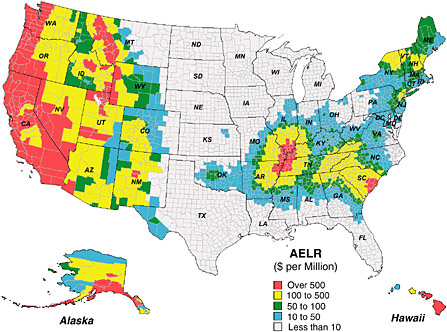
FIGURE 1.7 Map showing average annual earthquake loss ratio (AELR) at the county level. SOURCE: FEMA (2001a).
|
BOX 1.5 Building codes have been recognized as one of the most effective tools for mitigating earthquake losses. The following examples illustrate the effectiveness of current building codes in reducing losses from earthquakes. Building codes, such as the Uniform Building Code and the International Building Code, became more effective as geoscience information from seismic monitoring and engineering information from damaging earthquakes were collected and analyzed as part of the NEHRP. Urban areas contain a mixture of buildings, built at different times to codes with different earthquake requirements. FEMA (1997) estimated that the losses (building damage, contents damage, and income losses) in an event similar to the 1994 Northridge earthquake would have been reduced by 40 percent ($16.6 billion compared with $27.9 billion) if all buildings had been built to current high seismic design standards prior to the earth- |
|
quake. Had no seismic standards been in place, losses are estimated to be 60 percent greater than those for the baseline 1994 scenario ($45 billion versus $27.9 billion). In other words, the development and implementation of seismic design standards in building codes can lead to a reduction in earthquake damage by about a factor of 3. A 2001 FEMA report, based on the HAZUS-99 earthquake loss estimation methodology, examined the impact of seismic rehabilitation in reducing the economic and social losses from magnitude 7.0 earthquakes on the Newport-Inglewood Fault in southern California and the Hayward Fault in northern California (see Feinstein, 2001). Two scenarios were evaluated (all costs in 2003 dollars):
For these two examples, a comprehensive rehabilitation program could reduce building and contents damage losses more than 25 percent and business interruption losses by more than 60 percent. Major injuries and deaths, numbers of displaced people, and those requiring short-term shelter would also be reduced by more than 70 percent. For a more meaningful cost-benefit analysis of the mitigation measures in these examples to be undertaken, the cost of mitigation and building to these higher design standards, the value of lives and the cost of injuries, as well as the expenses associated with displaced persons, would all have to be specified. |
justifying such activities. This has become increasingly important in the existing funding environment where scientific programs are required to demonstrate economic relevance. In response to the need for an independent statement describing the economic benefits of seismic monitoring, the USGS requested that the National Research Council conduct a review with the following charge (Box 1.6):
The review committee established by the NRC to address this charge received input from a variety of experts and interested parties during its information-gathering meetings—from federal agencies, state agencies, local jurisdictions, private companies, and the academic community. In this report, the committee specifically addresses the benefits provided by monitoring data derived from seismometers, but does not include the data provided by geodetic instruments and networks (e.g., GPS stations), which conceivably might be included within a broader definition of seismic monitoring. In addition, the analysis of seismic monitoring costs is focused on earthquake-related monitoring—strong motion instrumentation and that component of weak motion instrumentation related to distant earthquakes.
|
BOX 1.6 An NRC ad hoc committee will provide advice regarding the economic benefits of improved seismic monitoring, with particular attention to the benefits that could derive from implementation of the Advanced National Seismic System (ANSS). In particular, the committee will:
|
One of the challenges facing the committee in its analysis of the potential economic benefits of improved seismic monitoring was to understand, first, how to quantify those benefits that are quantifiable and second, how to give appropriate credit to those benefits that cannot realistically be quantified but are nevertheless valid economic benefits to the nation. Given the time constraints and the nature of the project, the committee concluded that a compilation of the broad range of potential benefits—quantified where possible—was the most appropriate and useful contribution it could make. The committee’s analysis and conclusions, described in the following chapters, discuss the contribution that scientific monitoring provides for decision-making (Chapter 2); the economic context for benefit calculation (Chapter 3); and the benefits of seismic monitoring information for hazard prediction and assessment (Chapter 4), loss estimation (Chapter 5), performance-based engineering (Chapter 6), and emergency response and recovery (Chapter 7). These various benefits are then integrated to form the basis for the committee’s overall conclusions, presented in Chapter 8. Although the specific charge to the committee was to evaluate the economic benefits of seismic monitoring, it was clear to the committee that decisions regarding the allocation of resources for improved seismic monitoring must also take into account the costs of improved monitoring. Accordingly, some measures of the cost-effectiveness of seismic monitoring are presented in this report.


