
7
Benefits for Emergency Response and Recovery
Seismic monitoring—and particularly the products derived from monitoring—provides important input for at least three basic components of emergency response: (1) response readiness, or the capacity of an organization to respond effectively to large earthquakes as reflected in planning and exercises; (2) management of earthquake emergencies, or the ability of an organization to mount a timely and effective response that minimizes the loss of life and property damage, and maintains operational capabilities; and (3) rapid recovery, encompassing the mitigation of hazards, restoration of the built environment, and return to normal community life. This section describes the impact of seismic monitoring on these three elements of emergency response and recovery, and examines the potential benefits of enhanced monitoring.
It is important to keep in mind that both the benefits of seismic monitoring and the examples that are cited in this section currently apply only to the limited region—essentially urban areas of California—where state-of-the-art networks are currently in operation and the density of network coverage is sufficient to provide relatively accurate information for emergency response and recovery. Other regions, despite their identification as areas of high or moderate seismic potential, currently realize considerably fewer benefits due to the lack of modern digital seismic and strong motion instrumentation, the lack of adequate station coverage to produce response-relevant products, or both.
MONITORING FOR RESPONSE READINESS
Organizations and individuals in seismically vulnerable areas of the nation seek to reduce risks in diverse ways, including informed land-use planning, structural and nonstructural mitigation, the purchase of insurance, and planning for response and recovery. It is this last strategy for risk reduction that is the topic of this section. Response readiness—action associated with development of plans and conducting exercises—relies on seismic monitoring to describe long-, intermediate-, and short-term earthquake potential, to provide information on earthquake effects, and to estimate the impacts of earthquakes on the community.
For areas of high seismic risk, the U.S. Geological Survey (USGS), state-level geological agencies, and academic scientists have used monitored information to develop projections of long-term seismic potential based on fault characteristics, local geological conditions, recurrence intervals for large events, and other factors (WGCEP, 1988, 1995, 2003). These studies have provided state and local government agencies and private sector entities with essential information for earthquake hazard reduction actions that include focused planning and prioritized hazard mitigation for areas judged to have the highest probability of large damaging earthquakes. These studies have also provided the basic information needed for the development of exercise scenarios to improve response readiness.
Organizations that must respond rapidly to a significant earthquake or other disasters typically conduct drills and exercises to test their readiness and the quality of their planning. These exercises vary in extent of involvement and degree of detail, from limited “tabletop exercises” that include a few key decision-makers gathered around a conference table, to full-scale field exercises that include many departments and full activation of emergency operations centers. With the development of ShakeMap, emergency response exercise scenarios have reached degrees of sophistication that provide substantial benefits for response readiness.
When combined with loss estimates from HAZUS, ShakeMap earthquake scenarios provide important details of potential earthquake impacts on a city, county, or region. In the past, response organizations relied on vague projections that were largely the result of guesswork regarding earthquake size and effects. The currently available ShakeMap-HAZUS scenarios include empirically grounded estimates of shaking intensity and regional patterns of shaking, and as input data for HAZUS, ShakeMap contributes to plausible estimates of total dollar losses, utility damage, building damage, and population impacts including the number of deaths, various levels of injury, the number of people displaced from their homes, and the probable demand for shelter and mass care. When mapped, these
estimated losses supply exercise participants with details that provide far more rigorous tests of response procedures, protocols, and plans than has been possible in the past. It is reasonable to assume that better scenarios and thus better exercises will result in greater response readiness.
Monitored seismic information also contributes to response readiness in short- and intermediate-term time frames. Although earthquake prediction has not developed as rapidly as was once hoped (see Chapter 4), monitored seismic data are crucial for identifying “hot spots” and seismic activity that could be precursors to large damaging events. Historically, such activity has triggered specific emergency response preparations. In California, there are reasonably well-defined areas in which earthquake activity or other monitored changes could greatly increase the short-term probability of large damaging earthquakes. One such hot spot is the southern terminus of the San Andreas Fault along the eastern shore of the Salton Sea. Earthquake swarms in this area or a single moderate-size event (Mw ≥ 5)—if interpreted by scientists as potentially precursory to a large event on the San Andreas Fault—would trigger activation of plans that require specific actions by the California Governor’s Office of Emergency Services (OES) and other agencies. Based on short-term changes in seismic activity, the USGS has recently commenced real-time forecasts, updated every hour, of earthquake hazard in California for the following 24-hour period.1
The State of California has developed a short-term earthquake advisory plan (OES, 1990) that contains detailed procedures for emergency activation and public warning based on scientific interpretation of monitored data. This plan calls on the OES to notify state agencies and local jurisdictions in the area of enhanced seismic risk and to issue a press release to the print and electronic media recommending actions designed to enhance readiness to respond should damaging earthquakes occur. The plan identifies methods for transmitting the advisory message and includes templates and sample messages to facilitate issuance of advisories in a timely manner, given that the advisory period will be from 3-5 days.
REAL-TIME INFORMATION FOR EMERGENCY RESPONSE OPERATIONS
The emergency response phase of an earthquake spans a period of time ranging from the initiation of the earthquake to the conclusion of activities designed to save lives, treat the injured, shelter the displaced, and assess the damage. Monitored information from seismic networks is
of critical importance during this phase, particularly in the initial stages. Beginning with indications of the occurrence of an earthquake fault rupture and continuing into the first few hours of the response, monitored data have a potentially wide-ranging impact on the timeliness, efficiency, and efficacy of emergency response.
Several nations—including Mexico, Taiwan, and Japan—have employed monitoring networks to alert user communities that potentially damaging ground motion is approaching from a distant earthquake. These “early-warning systems” may provide from a few seconds to a few tens of seconds warning, thus facilitating life safety and rapid hazard mitigation actions. Both the network operators, and those who have studied behavioral responses to earthquake early warning systems (e.g., Tierney, 2000; Shoaf and Bourque, 2001) have identified a number of actions that can be taken in response to a warning. These actions include taking cover, moving away from hazards, evacuating vulnerable buildings, programming elevators to stop at the next floor and open doors, shutting down computer systems, slowing down or stopping trains, and a range of other possible activities. Although earthquake early-warning systems based on modern digital seismic networks could be implemented in the United States and are being planned as part of future Advanced National Seismic System (ANSS) activity (Leith, 2005), such systems require the dense seismic networks and real-time telemetry that currently exist only in California’s two major urban areas.
Although early earthquake warnings are not yet a reality in the United States, warning systems for tsunamis have been in place since 1948. As noted in Chapter 4, the National Oceanic and Atmospheric Administration’s (NOAA) National Weather Service operates two tsunami warning centers, one in Palmer, Alaska, and the other in Ewa Beach, Hawaii. The goal of these centers is to rapidly and accurately identify events that could trigger a tsunami and provide timely warnings to coastal communities that may be impacted. These warnings, if accurate and timely, can save lives based on rapid evacuation of areas likely to be affected by damaging tsunami waves.
It is in the immediate post-impact period that information from seismic networks has the greatest potential benefit for emergency response. In areas where dense arrays of modern digital instruments are deployed, emergency response agencies now have resources available to them that will affect all aspects of emergency response—resources that were not available during the Northridge earthquake of January 17, 1994, an event that remains one of the costliest natural disasters in the nation’s history. After the Northridge earthquake, monitored seismic information, consisting of magnitude and location, played a relatively minor role in response. The significant enhancement of the Southern California Seismic Network
under the 1997-2001 TriNet Project resulted in improvements that greatly increased the quality and quantity of information available to responders in the minutes and hours following a future damaging earthquake.
The very rapid availability of earthquake source data—including magnitude, location, depth, and fault geometry—provides basic orienting information for emergency responders, essential information for the news media and the public, and input data for other applications and response-relevant products. Maps of ground shaking intensity (ShakeMap) have many important applications in emergency management. Because ShakeMap is available via the Internet, all emergency responders at all levels of government and the private sector have access to the same rapidly available information. With this information, responders can quickly assess the scope of the emergency and mobilize resources accordingly. Early reconnaissance efforts can target areas known to have been shaken most severely, and key emergency services including search and rescue, emergency medical response, safety assessment of critical facilities, and shelter and mass care can be expedited based on a more rapid identification of incident location. Monitored information is also useful for rapidly assessing situations in which a large, widely felt earthquake occurs but causes little damage (such as the Hector Mine earthquake of October 16, 1999). Clearly, there are significant economic benefits in scaling a response to the consequences of an event, including no response for an earthquake that requires none.
Based on ground motion data from seismic networks, HAZUS can be used to generate estimates of economic losses, utility system damage, and population impacts. These data provide information useful for several response and recovery actions (discussed in the following section). For response actions, HAZUS outputs will supplement the ground shaking information from ShakeMap by estimating the level of damage to buildings, utilities, and transportation infrastructure; contribute to identifying the appropriate response activation level; provide guidance for initiating building safety assessments; help determine the number of shelters that must be opened to house the displaced; and provide an estimate of the amount of resources needed to care for people in temporary housing.
Monitored data from instruments on or near buildings and other structures can also provide the means to conduct real-time damage assessment of critical infrastructure (e.g., hospitals, highway bridges, emergency operations centers) and avoid secondary hazards (e.g., from dams, natural gas or petroleum pipelines, etc.). Emergency response based on monitored data can be used for rapid or automated closure of damaged bridges, evacuation of areas vulnerable to dam collapse, actions by utility operators to preserve electric power and gas, and rapid notification to emergency medical transportation units regarding the damage status of hospitals and
trauma care centers. These data might also be used to prioritize safety and damage assessment, repair, and restoration.
Response operations—including search and rescue, shoring or demolition of damaged structures, and safety inspections—are vulnerable to secondary hazards posed by aftershocks and additional earthquakes that are triggered by the initial ground shaking. Rapidly available information from seismic networks can reduce exposure to these risks. The location and magnitude of large aftershocks and triggered events can be estimated using models (Jones and Reasenberg, 1989; Reasenberg and Jones, 1994) based on the observation and analysis of an evolving sequence of earthquakes. This information can be used to establish cordons, restrict access, and warn responders. After the 1989 Loma Prieta earthquake, portable instruments were placed near the epicenter in the Santa Cruz Mountains and alerts were broadcast in real-time to crews working on the collapsed portions of the Nimitz Freeway (Interstate 880), providing 10-20 seconds warning that ground motion from aftershocks was imminent (Bakun et al., 1994). Aftershock location and magnitude estimates, in combination with alerts based on monitored information, can provide an additional margin of safety and risk reduction for responders.
Reliable operation of seismic monitoring networks is a critical requirement for providing earthquake information to the emergency management community. Like all lifeline infrastructure, seismic networks are dependent on electric and telecommunication utilities as well as the Internet. Consequently, efforts to upgrade the national monitoring capability should include long-term maintenance of existing instruments and communications infrastructure as well as deployment of new instruments.
MONITORING FOR EARTHQUAKE RECOVERY
A popular saying among emergency managers regarding earthquake disasters is that “recovery begins when the shaking has ceased.” Planning for recovery must begin immediately and concurrently with response activities. Although response is fundamentally local in character, recovery from a large damaging earthquake is regional and national in scope, involving every level of government as well as the private sector. Recovery decisions involve budgetary allocations and the activation of programs for individual victim support, long-term housing reconstruction, business and economic recovery, and hazard mitigation. These decisions, like those linked to response, can benefit from the rapid provision of information from modern seismic networks.
HAZUS loss estimates, based on monitored ground motion data (ShakeMaps), can expedite local, state, and federal disaster declaration processes by providing a potential basis for the preliminary damage
assessment required under the provisions of the Stafford Act for the activation of state and federal resources. These estimates also facilitate a more efficient damage assessment of critical facilities (e.g., hospital damage and availability), help determine the resources needed to care for people in temporary housing, and provide the necessary information to mobilize state and federal disaster recovery programs. The 2001 Nisqually earthquake is a pioneering example of this process. State Governor Gary Locke received an initial HAZUS-based damage estimate 90 minutes after the earthquake, declared a state of emergency, and used the HAZUS estimates in a request for federal disaster assistance the next day.
Although regarded as a response activity, the disaster declaration process has major implications for an efficient recovery. If the costs associated with response and recovery from an earthquake disaster are judged to exceed the capacity of local government to pay without outside aid, the Stafford Act provides a mechanism for appeals to successively higher levels of government for financial and material assistance, up to and including a presidential declaration. At times, this process has been hampered by divergent estimates of community impacts and disagreements over resource needs. With the development of modern seismic networks—in combination with the loss estimation capabilities of HAZUS—this process can become more efficient and relatively free of conflict. HAZUS provides the rapid, reasonably accurate, and objective estimate of total dollar losses from an earthquake that is needed for a preliminary damage assessment. This assessment is an important component both in the decision to issue a disaster declaration and, if declared at the national level, in determining an appropriation from Congress for recovery.
Damage assessment involves the inspection, detailed description, and estimation of repair costs on a structure-by-structure basis following a damaging earthquake. Although HAZUS estimates losses on a regional rather than site-specific basis, the combined data from ShakeMap and HAZUS can identify census tracts in which buildings of a particular construction type may have sustained damage and thereby facilitate a prioritization of the assessment process. Additional information available from HAZUS, including average income and ethnicity, can alert recovery planners to the need for translators or information that would facilitate the administration of other assistance programs.
Many local, state, private nonprofit, and federal programs are available to assist individuals and organizations during recovery from a major disaster. They include loans and grants that help victims repair homes and businesses and pay mortgage or rent. These programs may also provide crisis counseling; disaster-related unemployment assistance; medical, dental, or funeral expenses; temporary housing; and other expenses. The contribution of seismic monitoring data to the efficient
administration of these programs can be demonstrated by the use of monitoring data from the Northridge earthquake for recovery actions (Box 7.1).
RECENT RESPONSE EXPERIENCES
As noted above, the potential benefits of enhanced seismic monitoring are currently being fully realized only in the small area encompassing urban Los Angeles and San Francisco. Other areas, despite high or moderate levels of seismic hazard, will not gain such benefits without a concerted effort to enhance the seismic networks in these regions. Recent
|
BOX 7.1 The Federal Disaster Housing Assistance Program is available to renters and homeowners to cover the costs of alternative housing if disaster-related damages render a primary dwelling uninhabitable. To qualify, an applicant must complete an application, indicate that the dwelling is not habitable due to earthquake damage, and usually wait 2-5 weeks for an inspection to verify that the damage is severe enough to warrant an alternative housing arrangement. After the Northridge earthquake, the pre-grant inspection was waived. Instead, a zip code-based seismic intensity map, using source data from the Southern California Seismic Network, was used to determine grant eligibility. If an applicant’s residence was in one of the 66 zip codes that corresponded to estimated Modified Mercalli intensities of VIII, IX, or X, the applicant was sent a check, reducing the delay between application and receipt of funds from weeks to a few days. A total of 49,000 checks—totaling $138 million in grants—were distributed. Verification inspections revealed that more than 90 percent of those receiving checks were eligible based on established program criteria (Goltz, 1996). This rather bold experiment is instructive in several respects. First, it demonstrates that seismic monitoring data have applications in the recovery as well as the emergency response phase of an earthquake disaster. Second, it indicates a willingness by state and federal program administrators to use monitored data to streamline and expedite the delivery of program benefits, thus reducing the anxiety and possible suffering of disaster victims. Finally, the technologies associated with seismic monitoring and loss estimation have advanced significantly in the decade since the Northridge earthquake and can now provide data that are more refined, accurate, and reliable for application to program needs. |
earthquakes outside California’s two major urban areas provide illustrations of economic losses due to inadequate seismic network information.
In the aftermath of the Nisqually earthquake of February 28, 2001, the American Red Cross deployed disaster response workers to Seattle based on the magnitude and location of the earthquake. This limited information indicated that the event impacted urban Seattle and, at Mw 6.8 (similar to the 1994 Northridge earthquake), was expected to have caused casualties and damage. Although new seismic instruments were being installed in the region under the ANSS program, these instruments were not yet networked; thus, the immediate construction of a ShakeMap was not possible. At a depth of 52 km, the earthquake failed to generate the serious impacts anticipated by the Red Cross and resulted in an overdeployment, costing the organization an estimated $250,000.
On December 9, 2003, an Mw 4.5 earthquake occurred 15 miles southeast of Columbia, Virginia (see Figure 7.1), an event that was widely felt in Virginia, Maryland, and parts of North Carolina. The earthquake caused intensity VI shaking in central Virginia, prompting the evacuation of several office buildings and a jail in Richmond. Although the shaking was felt by many, earthquakes of this magnitude are unlikely to cause damage in engineered structures and the evacuations were unnecessary, resulting in disruption and loss of productivity. Enhanced seismic monitoring, including the placement of accelerometers in buildings and near infrastructure, expedites the immediate post-earthquake safety evaluation of structures and can be used either to avoid needless evacuations in smaller earthquakes or to expedite evacuations in larger events where the safety of occupants is jeopardized.
Although timely information was provided by the California Integrated Seismic Network following the recent Mw 6.5 San Simeon earthquake of December 22, 2003, this information proved to be inadequate for an effective emergency response. Because the initial ShakeMap was based on data from the only two seismic instruments available, the map failed to reflect the strong motion that caused damage in Paso Robles—an error that additional seismic instrumentation coverage would have prevented. Responding on the basis of this first iteration of ShakeMap, the California Transportation Department (CalTrans) deployed bridge and highway inspectors to Highway 1, rather than Route 101 where damage was much more likely because of the southeasterly direction of rupture propagation. HAZUS loss estimates, based on the earliest version of ShakeMap, underestimated damage.
As these recent experiences indicate, the ShakeMap and HAZUS outputs derived from modern seismic monitoring networks can provide significant benefits for emergency response and recovery. For those very few regions where sufficient monitoring is available, the benefits of such
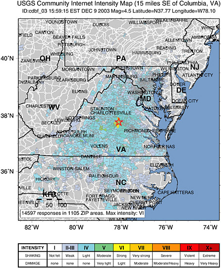
FIGURE 7.1 Community Internet Intensity Map for the Mw 4.5 earthquake near Columbia, Virginia on December 9, 2003.
SOURCE: USGS internet output. See http://pasadena.wr.usgs.gov/shake/ne/STORE/Xcdbf_03/ciim_display.html.
monitoring include rapid and accurate identification of the event, its location and magnitude, the extent of strong ground shaking, and estimates of damage and population impacts. This information enables rapid mobilization at levels appropriate to the emergency and facilitates rapid identification of areas requiring prioritized response.
SUMMARY
Seismic monitoring and the products that are derived from modern networks—including ShakeMap and HAZUS—offer significant benefits for emergency response and recovery. The benefits of enhanced seismic monitoring include rapid and accurate identification of the event, its location and magnitude, the extent of strong ground shaking, and estimates of damage and population impacts. This information expedites hazard identification, promotes rapid mobilization at levels appropriate to the emergency, and facilitates the rapid identification of buildings that are safe for continued occupation and those that must be evacuated. While it may be reasonable to surmise that—in the context of the $100 billion single-event estimate—improved (in particular, more targeted) emergency response would yield avoided costs in the range of tens of millions of dollars, there simply is insufficient information to provide a rigorous basis for quantitative estimate of potential benefits. Such estimates can be provided only by post-earthquake analysis of a region that has adequate seismic monitoring.
These are tangible benefits to the emergency management community and, ultimately, to residents of seismically active regions of the country. Although difficult to quantify, the ultimate benefits are lives saved, property spared, and human suffering and anxiety reduced. The trail that leads back from potential benefits to seismic monitoring is one of technological innovations that are directly linked to monitoring. Adequately monitored regions make robust ShakeMaps possible, by translating ground motion into the locations of potential damage. Armed with almost immediate information on such potential damage, emergency managers can first determine appropriate levels of response mobilization and then allocate those resources appropriately to search and rescue, fire suppression, transportation route recovery, and other response activities. How many lives are saved? How many fires with the potential to consume dozens of structures are suppressed before they are able to do so? How many injured people are spared avoidable suffering? Such benefits are difficult to quantify because there are so few regions where modern digital monitoring systems have been installed and because there have been no large damaging urban earthquakes in these areas since modern networks have been installed.
Large damaging urban earthquakes will occur again, and they will not necessarily occur in areas that are adequately monitored. However, if they do hit monitored areas, researchers will have an opportunity to assess quantitatively and qualitatively whether the use of ShakeMap, HAZUS loss estimates, and other products derived from monitoring made a significant difference in the timeliness and efficiency of emergency response. This assessment could be accomplished through careful content analysis of duty logs, after-action reports, hospital admission records, shelter records, and other documentation of response and recovery activities, comparing time frames and content with records of earthquakes of similar characteristics that occurred prior to the use of technologies based on seismic monitoring. Surveys could also be conducted to determine how these monitoring-based technologies were used and how effective they proved to be. Only over the last decade or so have seismic networks, because of significant advances in computing and software, developed capabilities that address the needs of emergency response and recovery. Partnerships between network operators and emergency managers in well-monitored regions are strong, new technologies are being integrated into response and recovery plans, and capabilities are waiting to be proven.


