
5
Population and Environment in Amazônia: Landscape and Household Dynamics
Emilio F. Moran, Eduardo S. Brondízio, and Leah K. VanWey
INTRODUCTION
Land use decisions by farming families provide a key context for examining the dynamic interactions between people and the environment and are at the core of our research project in the Amazon Basin. Throughout our work in this area, we have focused on the decision-making processes of farm households, how these processes affect land use, and then on how the changes in land use (a social concept) are linked to changes in land cover (an environmental concept). When we began our research in this area, studies examining the causes of deforestation often neglected the dynamic interactions between the human population and the environment, and few studies had paid attention to the role of micro-level decision-making processes, particularly regarding reproductive and migration behavior, underlying regional patterns in population and environmental change. Since then, other teams of researchers, some represented in this volume, have also taken up this challenge. This body of work shows that when only looking at aggregate total population as a cause, the process of deforestation tends to be simplified. To get at the causes of deforestation, we need to examine how households make constrained decisions within their regional context, the land tenure system in place, the opportunities available to households to use their resources, the needs of a given household shaped by age and gender structure, and how members of households understand and make use of their physical environment.
This chapter documents the evolution of a project that has made use of a broad array of theories, methodologies, and conceptualizations linking
traditional household demographic surveys to time-series analysis of remotely sensed data in a spatially explicit framework made possible by geographic information systems (GIS). The use of multiple theoretical approaches and methodologies has been key to the past and ongoing success of this project. By asking timely and complex sociodemographic and biophysical questions, this project speaks to diverse audiences and has attracted researchers from diverse research traditions. The ability of the project to answer questions about the dynamic interaction of population and environment is due to the collaboration of these researchers without the subordination of one particular group of collaborators (i.e., natural or social science).
Over the more than 30 years of our research project, we have been guided by theoretical approaches too numerous to adequately describe in this chapter. We have utilized theoretical approaches that are based in our disciplines of training (anthropology, sociology, demography) but have also incorporated the insights of other disciplines. The key to our theoretical foundations is the dynamic nature of human-environment interactions. The cultural ecology and ecosystem ecology perspectives that motivated the early work on this project, as well as the demographic theories of population change that underlie more recent work, focus on the ways in which human populations adapt to and change their social, cultural, and biophysical environments. At the same time, we utilize theories that allow agency for individuals and families and discard those that posit structural determinism. Throughout this chapter we make brief references to the theoretical perspectives guiding each phase of the project, and we have given theoretical perspectives a more detailed treatment in VanWey, Ostrom, and Meretsky (2005).
The integration of methods from various research traditions both allows the research team to speak to all participating disciplines and brings new insights into each discipline. This project has fruitfully combined data from soil samples, remote sensing (aerial photos and satellite imagery), social survey research, and in-depth qualitative data collection (ethnography, open-ended interviews). The soils data were originally included in order to address the concerns raised by Meggers (1954, 1970) that the humid tropics could not sustain agriculture above the slash-and-burn level. Survey research has been a longstanding tool for collecting household social and economic data. Qualitative data represented the anthropological focus of the original study, supplemented with environmental data collection to study the human-environment interactions from a cultural ecological perspective. The introduction of GIS into the project allowed us to integrate point data on soils, household location and survey data, and continuous data on land cover across the landscape. This allowed us to study the ways in which landscapes embody a historical summary of past land use and are
the consequences of a given demographic trajectory and the changing dynamics of the interaction between a population and its environment (Crumley, 1994). Through the use of remote sensing and archival data, we have made efforts to reconstruct the history of landscape formation in the colonization areas of the Trans-Amazon Highway. Thus, we track the initial occupation of farm-lots and the temporal process of their transformation resulting from land allocation decision making by families arriving from different places and at different periods.
The motivations for this project of 30+ years have always been both social and environmental. We have been guided throughout our research by two basic questions: (1) How do environmental characteristics constrain human action? (2) How does human action modify the environment? Settlement of the Brazilian Amazon entailed the mass migration of families from throughout Brazil into the interior of the country, a region previously occupied primarily by indigenous groups.1 This dramatic demographic transformation of the Amazon was accompanied by changes in the environment, specifically by the removal of forests in favor of agriculture, and in economic infrastructure providing road access and establishing the presence of government institutions. In the tropics it has been all too common to blame the smallholder for tropical deforestation (Myers, 1984) or to stress the role of a political economy that favors large-scale farmers and ranchers (Schmink and Wood, 1992). We have focused on how small-scale farmers deal with macro-political economic forces within the constraints of specific landscapes, their own age and gender structure, the local community social structure, and the capacity of local institutions to buffer those external political economic forces. For example, we consider how past agricultural experience and migration history have affected the results from management by different households; how labor was shared through kin and religious networks; and how age and gender structure affected labor availability and cash flow in households. Thus, our project has always focused on understanding the linkages between the actions of individual smallholders and broader landscape change.
The Brazilian Amazon is a region of particular significance on both environmental and demographic grounds. The Brazilian portion of the Amazon accounts for two-thirds of the Amazon Basin or 4 million square kilometers (km2). Moist and rain forests of the tropics cover only 11 percent of the Earth’s surface, but they contain 41 percent of the global terrestrial biomass and over 50 percent of the fauna and floral species. The Brazilian Amazon accounts for 26.5 percent of the Earth’s moist forests (Whittaker and Likens, 1975; Salati and Vose, 1984; Prance and Lovejoy,
1985; Silver, 1990). Contemporary impact on tropical moist forest tends to come from government development planning, resulting in the construction of roads and settlement schemes to bring farmers to the forest to begin agricultural production, as well as from private enterprises claiming forest land for logging and farming ventures. The population of the Brazilian Amazon has been increasing through such development and settlement schemes, with a deforestation rate averaging 0.5 percent or about 30,000 square kilometers per year between 1975 and 1997. Before 1975, only about 30,000 square kilometers appeared to have been deforested. Since then, the average yearly deforestation has been equal to the total deforestation up to 1975. Deforestation rates in settlement schemes, such as this chapter reports on, can vary between 1 and 6 percent per year, as these are “hot spots” of deforestation—at least during the early years of settlement. It is this process that led to the commencement of this project.
To sum up, our research has evolved through phases of theoretical, methodological, and individual interest since 1972. Initial research in the area focused on understanding human adaptation to the frontier using cultural ecology, agronomic and ecosystem ecology approaches (Moran, 1975, 1976, 1979, 1981). During the 1990s we focused on understanding land use–land cover dynamics following deforestation by linking remote sensing, GIS, vegetation and soil inventories, and land use history. Studying the secondary succession dynamics at the level of vegetation stands and landscapes provided a context in which to understand cycles and strategies of land use, such as rates of fallowing, stages of lot formation, the role of soil fertility in the forest regenerative capacity, and the ability of farmers to keep cleared land in production (Moran and Brondizio, 1998; Moran, 1993; Moran et al., 1994, 1996, 2000; Tucker, Brondizio, and Moran, 1998). Since 1997 our research has focused on linking, spatially and temporally, household demographic and land use change (Brondizio et al., 2002; McCracken et al., 1999, 2002; Moran et al., 2002; Siqueira et al., 2003). In its current stage, we are examining the dynamics associated with second and third generations of migrant farmers, as well as the demographic changes occurring not only at the level of households, but in the larger region.
THE FIRST STAGE OF THE PROJECT (1972-1984): ADAPTATION IN A TROPICAL FRONTIER
The research on which this paper is based began 32 years ago and has continued over that entire period at regular intervals. It began in 1972 as a dissertation project (Moran, 1975) using the theoretical framework of cultural ecology (Steward, 1955) and ecosystem ecology (Odum, 1971; Rappapport, 1968) and focused on understanding the ways in which the
biophysical environment constrained and influenced human action. The motive for the study was the announcement in 1971 by the Brazilian government that it would undertake the opening of the Amazon forest to development from one end to the other by means of roads of national integration. Settlement schemes were a central part of this plan with the goal of populating the “empty” Amazon with settlers from throughout Brazil as a way of integrating a region that constituted 54 percent of the national territory into the national strategy of economic development (Programa de Integracao Nacional, 1971). The major road at the center of this program was the Trans-Amazon Highway, running east to west across the Brazilian Amazon. In a short period of three years, the military government was able to build this road and to settle thousands of families along the main trunk of the road and on side roads. The central question guiding the research was understanding how the different migrating groups would adapt socially and environmentally to life in a tropical rain forest ecosystem, particularly to farming in a largely unfamiliar habitat and cultivating soils of below-average fertility (Moran, 1975, 1977). Interestingly, the results pointed less to environmental limitations than to failures of institutions to deliver to farmers promised inputs as culprits in the low yields many of them obtained. The methods used were a combination of ethnographic approaches (living in the community for over a year, participant-observation) and environmental approaches (soil sampling, tree measurement, hunting and gathering weightings, agricultural labor input-output measurements using ethological methods).
The study undertaken by the first author of this chapter sought to document the social and environmental impacts of large-scale settlement by focusing on a showcase site along the road, the Altamira site on the Lower Xingú Basin. This site became a focus of particular attention by government because of the presence of above-average fertile soils (Falesi, 1972). The early advertisements about the project touted the high fertility of the soils and the bumper harvests possible (Ministerio da Agricultura, 1971). Settlement followed a classic “fishbone” pattern (see Figure 5-1), which had been used earlier to settle parts of the state of Paraná, in southern Brazil, and which has become associated with a Brazilian style of settling the Amazon frontier: a main trunk with regularly spaced side roads that create a distinctive pattern visible from satellites (see Figure 5-2).
Before the arrival of the Trans-Amazon Highway and its associated settlement scheme, the Altamira region had been sparsely settled, with a town of less than 1,000 persons along the Xingú River and several posts for trading rubber collected by rubber tappers upriver. In the 1950s the town promoted a small-scale colonization project that brought several dozen people from Piauí, in northeast Brazil, who settled along the first 18 km west of the town of Altamira. As elsewhere in the Amazon, along the rivers,
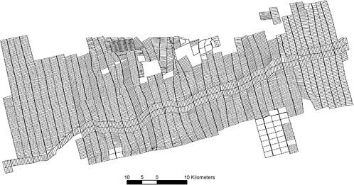
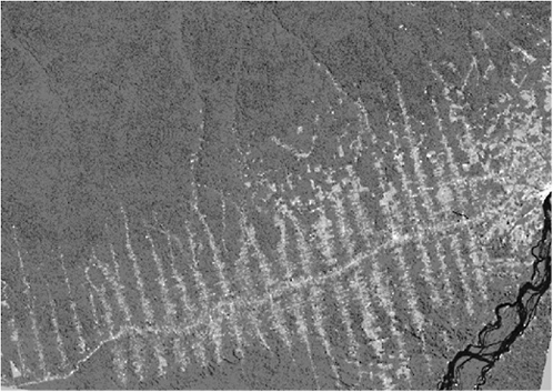
FIGURE 5-2 Landsat TM image of Altamira region.
isolated households of caboclos (native non-Indian Amazonians, see Moran, 1974) lived by hunting, gathering, and tending small manioc fields. Many of these caboclos moved a short distance from their riverside locations to the highway to make land claims when the highway came. Most of the area was forested in 1971, except along those first 18 km out of town, and the settlement scheme began to divide land holdings from that point west of Altamira into a fishbone pattern. Large patches of fertile soils could be found along those first 20 km, and thus government officials promoted the fertility of the soils of the region as being uniformly high, which proved later not to be the case. There are two types of forest in the area—liana forest and dense humid tropical forest. The former is associated with a dense presence of vines, and it has been suggested by some scholars that this forest type is associated with disturbance by prehistoric Amazonians (Balée, 1989). Indeed, in these areas and their associated fertile alfisols (i.e., moderately leached forest soils), there is an abundance of Tapajoara pottery and patches of anthropogenic black soils, both of which bear testimony to the use of these fertile areas by prehistoric populations associated with, or who traded with, the pre-Columbian chiefdoms along and near the Tapajós River (Smith, 1982).
Between 1971 and 1974 the process of settlement proceeded at a very rapid pace, as the government selected farmers from throughout the country for the project, bringing them by plane, boat, and bus at government expense (and with a guarantee of a return trip if they did not find the area acceptable). Selection criteria used by the government, when examined carefully, were overwhelmingly driven by the size of families. The larger the family, the more likely they were to be selected—a process that resulted in an older than average age for heads of household and a substantial dependency ratio. Agricultural experience was an official criterion, but there was no verification carried out to establish whether statements were true, nor did the criterion distinguish between experience as an owner, a rural wage laborer, or a share-cropper (Moran, 1976, 1979). Upon arrival, settlers were given certificates of occupation, which allowed them to obtain year-to-year loans for agricultural production (but not long-term loans). They were promised land titles, but this process proved to be very slow and difficult for most of them. A few settlers familiar with the process undertook expensive trips to distant towns where they could make their land claim and obtain title, but fewer than 5 percent undertook this process. Even after several years, fewer than 30 percent of the people had received the promised titles. The certificates of occupation could not be passed on through sale. The titles could be reissued to someone who bought a property, but because the process was slow and expensive, most people who bought land from someone simply kept the old title and some rather informal document from the seller to establish ownership. Over time, more complex arrangements have evolved, but the lack of a rigorous titling process has been one of the factors that has prevented a stable land market from emerging, and it may also have influenced the tendency not to fragment properties, as it would be even harder to establish rights to fragments than to entire properties. Inheritance of property has not been seen to be a problem, except in those cases in which several children wish to have land, and resolution of these cases is usually informal rather than legalized through titling.
Adaptation in the frontier was shaped by the intervention of the government in the selection of households and by their intervention through credit programs, extension, and the quality of roads that were constructed to market the produce. As a result of government selection criteria, the demographic age-gender pyramid for the settlers in the study area was quite peculiar—it did not have as the broadest segment the 0-4 age group, which is common for fast-growing populations, and was almost even for the 0-4, 5-9, and 10-14 cohorts, who accounted for 55 percent of the population. It had very few persons above age 50 (2.4 percent) and was remarkably thin in the 20-24 and 25-29 cohorts—usually the most common age cohorts in frontier and migrant populations for a bulge in the heads of household (Moran, 1981:88-89). In this area during the first three years of settlement,
the largest cohort of heads of household were in the 40-44 and 45-49 cohorts. Mean household size was 6.2, consistent with the national mean (Moran, 1981). Thus, rather than reflecting a classic migrant population of very young migrants, the migrants to this frontier in the early years were about 10 years older on average and had a larger dependency ratio than is normal (but also more available labor to cut more forest). The low rate of interest provided by the Banco do Brasil (Bank of Brazil), upon orders from the president, accelerated the rate of deforestation and, when combined with larger and older households, resulted in higher deforestation rates than might have been expected.
Although a host of institutions were present, they were understaffed and poorly informed about the environmental conditions of the area, contributing to many decisions that exacerbated the propensity to fail in these critical early years—particularly the failure to maintain roads, provide adequate health care, and take into account the high rates of rainfall and the importance of drainage to prevent malaria outbreaks. It must be noted that the process was a classic case of a top-down command economy undertaking. At the time it was touted as “the equivalent of placing a man on the moon.” There was an effort to make available the entire set of national institutions in the frontier all at once, but, because of the difficulties of life in the region, few members of those bureaucracies wished to go there. To encourage acceptance of positions in the frontier, double salaries were paid. This attracted largely young people wishing to save for their starting professional careers, but they lacked experience in managing something as complex as this in an unfamiliar environment. The speed with which immigrants were brought to the area by the government contributed to the difficulties of delivering services, as did the poor quality of the roads, particularly in the rainy season.
The settlement scheme very clearly laid out that settlers could clear only the front 50 percent of their properties, with the notion that the 50 percent of the back of lots would remain forest, thereby constituting a fairly uninterrupted expanse of forest for conservation. However, this was interpreted creatively by some settlers to mean 50 percent of whatever forest they had upon buying a property, and thus as land turnover occurred, the new owners would encroach on the forested 50 percent. Moreover, there was no capacity to monitor whether farmers were abiding by the 50 percent rule or not. As satellite imagery began to be used, it became clear that there was enormous variability in how farmers behaved with regard to the 50 hectares to remain in forest out of the total 100 hectares of each property, with some properties having deforested virtually the entire property, while others were well within the 50 percent established area.
The conclusions of this first phase of the study were reported in several monographs (Moran, 1975, 1976, 1981) and in many articles (among them
Moran, 1977, 1979, 1982, 1984, 1988, 1989). In short, Amazonian natives outperformed migrants in yield per hectare, in use of technology, and in overall well-being—contradicting government expectations. Soils proved to be highly variable—not invariably acid and nutrient-poor, and Amazonian natives were more often able to identify better soils, thereby obtaining higher yields per hectare than newcomers. The role of soils in shaping the path of land use has proven to be very important in subsequent research, with farms on good soils being more resistant to turnover of ownership than those on poor soils, and they tend to have a more diversified production portfolio. Previous agricultural experience as managers of a farm property resulted in rapid success in the Amazon frontier and in capital accumulation, both in use of credit and in acquiring local knowledge and applying it to production goals—and these management skills were not geographically concentrated in migrants from the south and southeast, as stated in planning documents. Those who were landless before coming were very likely to become landless again after a short time through farm failure and inability to pay bank loans, and previous high rates of migration were associated with low incomes and farm failure in the new frontier. Those who were most dependent on government institutions were most prone to fail, given the difficulty for state institutions of reliably delivering services in a timely fashion and with a technology appropriate for the local environmental conditions.
THE SECOND STAGE OF THE PROJECT (1991-1996): SECONDARY SUCCESSION AND LAND COVER CHANGE DYNAMICS
Beginning in 1991, we moved from examining social outcomes for farm families to examining the environmental outcomes of human action in the region. This work involved analyses examining both the lot- and landscape-level outcomes of farm-household decisions over time. The focus of this work was on understanding what factors explained the differential rate of secondary succession forest regrowth following deforestation. Until this date, there had been a tendency even among scientists to ignore the fact of secondary forest regrowth and to consider deforestation only (often followed by what was sometimes called “desertification” or degraded pasture development). Our work sought to correct this oversight, while developing methods to integrate ecological and spatial aspects of land clearing and fallow cycles necessary to understand land use change and agricultural choices of colonist farmers. This insight came from the farmers themselves who, when queried with the question “What factor most limits your ability to succeed in farming in this region?” responded most often by saying that it was the vigor of the regrowth—with the pioneer species in the
secondary vegetation often being several feet high before they could even plant their crop after burning. Studying regrowth and fallow cycles provided us with tools to understand the demands for labor and technology faced by farmers in the area.
The project took new directions by linking techniques of satellite remote sensing and GIS that permit scaling up from local communities to a much larger landscape captured by Landsat Thematic Mapper (TM) images (185 by 185 kilometers). We used a combination of remote sensing, GIS, forestry, and social survey research, which included components on ethnoecology, demography, land tenure, land use history, production and consumption, marketing of production, credit used, and aspirations for the future. Moran and Brondizio worked together in this stage with several colleagues, developing new methods for linking the behavior of farming households to their use of soils and land use practices and to the pixel data from the satellites (Mausel et al., 1993; Brondizio et al., 1994, 1996; Brondizio and Siqueira, 1997; Moran and Brondizio, 1998; Moran et al., 1994, 1996).
During this period, a great deal of effort was spent on collecting land use histories using interviews and remote sensing data in preparation for vegetation and soil surveys. The goal of this intensive environmental data collection, besides improving the classification of remotely sensed data, was the linkage of detailed environmental information to farm-lot and regional trajectories of land cover change. Consequently, by combining the ability to discriminate deforestation events and stages of secondary succession with a property grid defining farm-lots, we were able to query and understand variation in land use and cover change at the levels of the farm and the larger landscape. In this way, questions such as “What is the rate of deforestation in the area?” could be answered at different levels, time periods, and, most importantly, in terms of variability within the region. Over 100 sites (2,000+ vegetation plots) were sampled across several study areas using standard vegetation survey methods (genus and species identification of all plants in plots selected, diameter at breast height, total height, height to first branch of tree species); soil samples associated with each site were taken with a soil auger to one meter depth. This resulted in a very large data set linking vegetation inventories, soils data, land use history, and spectral data from Landsat TM images from 1985, 1988, 1991, and 1996.
During this phase of the study we expanded from the Altamira site to include an estuary site (Marajó), and two eastern Amazon sites characterized by relatively poor soils to contrast with Altamira and with longer histories of settlement (Igarapé-Açú—in the Bragantina region near Belém, and Tomé-Açú—an area settled by Japanese immigrants in the 1930s). In addition, we were able to do brief fieldwork in the northwestern Amazon in the Vaupés River region of Colombia among Tukanoan native Amazonians
in an area characterized by extreme infertility of soils and by native strategies of resource use largely disconnected from external markets. The goal was to examine what explained the differential rates of forest regrowth following deforestation under a variety of soil fertility conditions, agricultural technologies, and densities. As it turns out, Altamira stood out well above all the other sites in soil fertility and had the fastest rates of secondary growth (Moran and Brondizio, 1998).
A considerable body of publications report on this part of the research (see http://www.indiana.edu/~act/pubs.htm). We found that land use by farmers explained most of the difference in rates of regrowth when comparing sites in a given region, but when comparing different regions of the Amazon that we have studied, soils proved to be a more robust factor in explaining differences. This finding suggests a more general conclusion, also supported by the work of Gutmann et al. (Chapter 4) and Walsh et al. (Chapter 6), that biophysical characteristics may stand out as limiting factors when considering large geographic units/extents, whereas human characteristics drive variation at the property or community level. Interestingly, rates of regrowth did not differ significantly between oxisols (highly weathered soils), ultisols (strongly leached, acid forest soils), and spodosols (acid soils with a subsurface accumulation of humus)—but regrowth on the fertile alfisols was considerably more rapid, and this difference accelerated over time (Moran and Brondizio, 1998). We found confirmation that initial soil selection played a key role in farmer stability, with very little turnover for farmers with substantial areas of the fertile alfisols (with very few plots with these soils entering the land market), whereas on the others soils, turnover was high. Moreover, we found that crop choice after 20 years of settlement had been profoundly affected by the soils present on the farm; we found a significant relationship between the percentage of fertile soils on properties and the diversity of the portfolio of the farm household, with over 80 percent of the area in pasture on the poor soils and a steady shift toward cash crops and tree crops with increases in the proportion of alfisols on the property (see Figure 5-3). This is affected by the predominance of cocoa and sugar cane in the Altamira area, both of which require fertile soils for good results.
Despite its many advantages, remote sensing data when used alone present a number of limitations to accomplishing land use assessment tasks, including limitations in temporal resolution in order to capture interannual land use changes and limitations in spatial and spectral resolution that would allow a distinction to be made between subtle land cover classes that are crucial to land use interpretation at the farm level (e.g., types of agriculture and agroforestry). Often, the growing period of most Amazonian crops coincides with high cloud cover, thus limiting image availability. The inclusion of detailed fieldwork and vegetation and soil inventories has been

FIGURE 5-3 Crops and Terra Roxa. Terra Roxa is an alfisol, a soil of dark red-brown color, nutrient rich, and of basaltic origin. It is very fertile with excellent drainage. As the proportion of terra roxa increases so does a farm’s crop diversity. Adapted from Moran et al. (2002).
important to overcome some of these limitations. Baseline research on vegetation inventories and interviews about the use of fallow areas has provided guidance for image analysis and in understanding land cover change. These include estimating rates of regrowth across areas of different land use histories, mapping of different stages of secondary vegetation to characterize fallow cycles across different land use systems, assessing the occurrence of economic species in fallow areas, and estimating aboveground biomass in landscapes characterized by different land cover complexities (Tucker, Brondizio, and Moran, 1998; Brondizio et al., 1996; Moran et al., 1996, among others). Still, this work needs to be combined with survey instruments aimed at capturing the farmers’ perspective on the sequence of crops planted, the arrangements of crops, and their location on the farm lot. As part of this process we developed several methods for using remote sensing images during land use interviews and survey techniques to capture the farmers’ perspectives on environmental management and land allocation. While still not ideal, the combination of this suite of methods and approaches helps us to understand the dynamics of land use and land cover change in the region, as well as how to best overcome the trade-offs and limitations of each tool and research instrument.
Important outcomes of this research include discriminating, mapping, and understanding of biomass accumulation in different stages of forest
regrowth, species dominance, and structural characteristics of mature forest and secondary forests in the region; and also finding that structural characteristics of the vegetation directly influence spectral data and are key features used during image classification. Using this approach, we have been able to differentiate up to three stages of secondary succession, which has in turn allowed for a more detailed estimation of above-ground biomass and cycles of land use (Mausel et al., 1993; Brondizio et al., 1996; Moran et al., 2000). As our work links to the larger literature on global environmental change, these variables on vegetation and soil and their relationship to spatially explicit spectral data have allowed us to contribute to debates about the estimation of carbon sequestered in secondary forests, nutrient cycling, and trajectories of forest recovery. Important issues include testing a selection of suitable variables and allometric equations for developing estimation of above-ground biomass to support biomass modeling at local and regional levels (Lu et al., 2002). Most important, perhaps, it allowed us to continuously test new methods of image classification (e.g., combining textural and spectral data) and achieve finer land cover discrimination. Deforestation is only one component of land cover change; as colonization areas age, secondary succession tends to dominate not only in areal extent, but in the decision making of farmers. In our Altamira study area, for instance, we found a total deforestation of 40 percent from 1970 to 1996; however, we found that deforestation rates vary widely both regionally (settlement level) and locally (farm level). We observed that, at the settlement level, half of the deforested area stayed in production, while the other half appeared in different stages of secondary succession (Brondizio et al., 2002). Our efforts at detailed land cover classification have been a fundamental step towards moving beyond the typical “forest and nonforest” distinction and closer to accounting for what farmers actually do on their lots.
The combined use of methods from forestry and ecology with the methods of social survey research provided a sound way to link the decisions of farmers to forest cover and to examine how subsequent land use was influenced by environmental factors (e.g., soils) and by constrained decisions by members of the household. This stage of research laid the foundations for the third phase of the work, which focused more closely on population dynamics as they interact with environmental and economic variables. A substantial database of soils, vegetation characterization and biomass measurements, and remotely sensed images laid the basis for the new phase.2
THE THIRD STAGE OF THE PROJECT (1997-PRESENT): POPULATION AND ENVIRONMENT IN AMAZÔNIA
As we worked over the years on this project, we came across many cases that seemed to suggest that households underwent significant shifts in land use strategy as they went from being young households to being older ones. In 1997, with support from the National Institute of Child Health and Human Development (NICHD), we undertook to clarify whether it was growth in population or the shifts in the age and gender structure of households that best explained the changes in deforestation rates that we observed using satellite data. For that study we posited a conceptual model, based on the theory of the developmental cycle of households (Goody, 1958, 1976), suggesting that the typical young household on the frontier has to focus primarily on production for household food needs, which results in rapid conversion of forest into annual staple crop production and the growing needs of a young family. Over time, the household is able to save and accumulate capital and more labor through the steady growth of the family, so that it is capable of expanding into other activities, such as cattle ranching and cash crops. However, as the children approach their late teens, the head of household begins to take into account the upcoming loss of this labor through marriage, and thus begins to reallocate land use toward productive uses that require less labor, such as tree crops (see Figure 5-4 for the conceptual diagram guiding this research).
To undertake this work we had the benefit of a property grid, detailed vegetation and soil data, and 25 years of familiarity with the region and the Altamira study site, its people, and government and nongovernmental organizations (NGOs). One of the powerful elements of this new approach, made possible by the existence of a property grid with considerable regularity, was the ability to link households to specific plots of land in what was mostly a one-to-one relationship. Although the property grid proved to be initially inaccurate, over several years of fieldwork we were able to develop at least 90 percent accuracy in the fit of the grid to observed data. Sources of initial inaccuracy included changes in the design of the planned versus actual road system and lot layout, fragmentation and aggregation of lots, variation in lot format according to topographic conditions, the opening of new roads by farmers, and the beginning of nonplanned settlements toward the end of feeder roads. Our team put a significant investment of time, resources, and personnel into collecting differentially corrected ground control points, systematically visiting each feeder road in the region, collecting ground control points in at least two corners of lots, and interviewing farmers about the shape and dimensions of lots. This corrected property grid allowed the project to make inferences about the impact of individual households on the land cover.
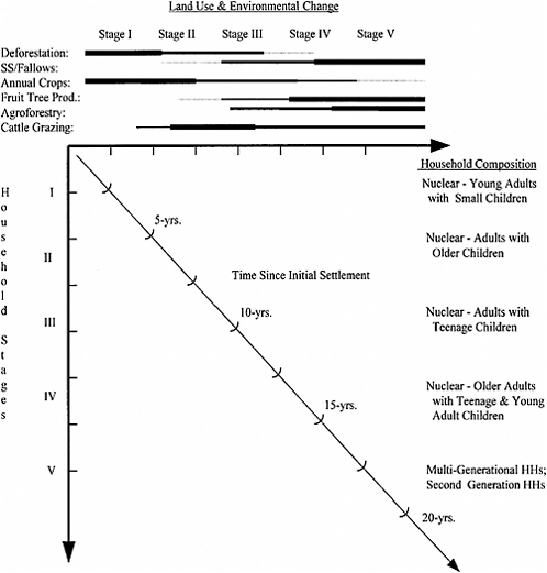
FIGURE 5-4 Conceptual model of demographic and environmental change. Adapted from McCracken et al. (1999).
While the first stage of this work (1972-1984) had already used multiple methods of data collection, processing, or analysis, each new stage has introduced new methods. The second stage (1991-1996) introduced systematic ecological methods for measuring species diversity, forest cover, remotely sensed data, GIS for integrating data, and spatial analyses. These innovations arose from efforts of Moran to develop remote sensing skills and from the addition of Brondizio to the core research team, as Brondizio came in with substantial skills in remote sensing and botany. Brondizio’s concern with studying land use intensification among small farmers and Amazonian ethnobotany helped to link vegetation, land use history, and
multitemporal remote sensing analysis. Similarly, his work was focused on developing methods and procedures for using remote sensing data as part of the ethnographic process. Global positioning system (GPS) technology, just emerging during the early 1990s, became an important element to link, for instance, interviews and visits with individual farmers to multitemporal satellite data.
The new methods in this third stage (1997-present) have included methods traditional in demography—large sample (relative to past work) social surveys and regression analysis. Our first NICHD-funded project (1997-2001) collected survey data from 402 households in Altamira and analyzed these data using ordinary least squares regression techniques. The current NICHD-funded project (2003-2006) aims to collect household survey data from just short of 1,000 households and to analyze these data using more sophisticated regression-based methods (e.g., event history analysis, spatial econometric analysis, logistic regression) in two regions—Altamira and Santarém. These innovations largely reflect the addition of traditionally trained demographers to the core research team (Stephen McCracken on the first NICHD project and Leah VanWey on the second NICHD project).
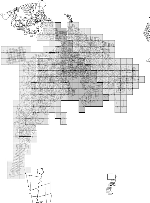
A particular contribution of this project to the population and environment methodologies is the generation of spatially explicit sampling approaches. In our 1998 Altamira survey, sampling was explicitly based on the arrival time on the lots of members of cohorts. We overlaid a property grid of 3,800 properties on the remotely sensed, time-series data, and added hydrography, roads and topography layers. The grid allowed us to focus on the individual property and to use the criterion for assigning membership in a settlement cohort to a household when we could detect in the imagery that five hectares had been cleared (a conservative figure given the average area cleared per year being three hectares and the interval in our time series being of three years). A full description can be found in McCracken et al. (1999). We divided the population into five cohorts and sampled disproportionately from each one so as to have relatively equal sized samples from each cohort. Plate 3 illustrates the distribution of cohorts in the study area. We received extremely good cooperation from sampled households in this phase of our work. Our research team encountered only one household that refused to participate. We completed 402 household surveys that examined demographic and socioeconomic history.
Using these data, we have indeed confirmed that households go through a developmental cycle that is related to the aging of the household and the farm, with distinct trajectories of land use and deforestation (Brondizio et al., 2002; see Plate 3). Most farm labor comes from the household, with very little wage labor used and very few cases of sharecropping.3 The
available household labor changes over the life of the household. More women than men leave their households, and they leave earlier to seek an education or marriage. This loss of women from households is partially made up by their gain of daughters-in-law. The next generation will be relatively small, because the pattern of fertility is very urban—most households are nuclear, rather than extended or multigenerational families, and the total fertility rate is around two children per woman in sampled properties. This low fertility may be related to the low rate of infant mortality in this frontier, with 40 deaths per 1,000 by the mid-1980s. Women use a variety of methods of fertility control, with sterilization being the preferred method and commonly used after the birth of the second child. By ages 25-29, more than 43 percent of women were already sterilized and the proportion continues to increase with age.
Corresponding to this demographic cycle, each of the arriving cohorts of settlers since 1970 followed a similar trajectory of exponential deforestation upon arrival and for about five years, followed by a steady decline in deforestation over the rest of the domestic cycle, except for a short pulse that we have come to call a consolidation phase toward the late stages of that generation before taking off again with the next generation.4 However, since the Altamira case only provided a single generation to observe, colleagues wondered whether the pulse at the tail end of the cycle represented the beginning of a new domestic cycle or an entirely different set of dynamics. With that in mind, in 2003 we began a new phase of the population and environment project, which added a much older settlement site wherein we might observe whether the cycles repeat themselves in the second and third generations. This new phase also added questions informed by traditional household demography approaches, focusing on the movement of individuals into and out of households and on the allocation of household labor. This project completed one of two planned data collections in summer 2003, and we are now testing our inferences about the domestic cycle across generations.
The new project allows us to examine set of questions generated by the first phase of the project regarding environmental constraints on human action and the environmental impacts of human action, among them:
-
Does the changing availability of household labor over the household life cycle affect the trajectory of deforestation and land use change in the same way for later generations of Amazonian farmers as for first generation in-migrants?
-
What are the determinants of changing household labor supply? Specifically, what are the biophysical and socioeconomic determinants of entries into and exits from the household through fertility, migration, and marriage?
-
How are the decisions of households regarding land use and labor allocation constrained by soil quality, access to water supplies, interannual drought events (e.g., El Niño–type events), and other resource scarcities?
-
Are there notable differences in land use choices made by landholders who live in an urban area (away from the piece of land owned in the rural area) in contrast to the decisions made by those who live on their rural properties?
-
What are the bases for the precipitous decline in female fertility in these frontier regions, especially the use of sterilization after two pregnancies?
We are able to explore these new questions through entry into a new study site—the agricultural areas around the city of Santarém. This region has a long history of human settlement and has different biophysical and institutional characteristics. The region has soils of middling fertility, a more marked dry season lasting at least four but sometimes six months, and large areas of secondary succession and of anthropogenic savanna. The terrain is flatter in most areas and has lower overall rainfall than Altamira. It is a much older area, having not only been an important pre-Columbian chiefdom, but also having served as a key trading center for the middle and lower Amazon, with a tradition of cattle ranching along the floodplain. The Santarém region presents significant differences in relation to soil types, distribution of water, and topography when compared to the Altamira region. While the fertile alfisols are not present in this region, one may find sparse patches of “black soil” (Terra Preta de Indío) and large stretches of floodplain soils along the Amazon River. The latter is subject to seasonal flooding. Water availability is one of the biggest constraints for farming and ranching in the region. With a low water table and sparse distribution of streams in most of the region, farmers often depend on strategies for saving rainwater and support from municipalities to provide in-farm water delivery. Rainfall is also characterized by a marked period of drought, ranging from three to five months (August to November). Land titling is relatively secure, and there is an active land market in the area. Large farmers from the south and the center west of Brazil have been entering the Santarém region to buy land for mechanized rice and soybean production in the past four years (to such an extent that national newspapers and international media, including the New York Times and The Economist, have reported on this trend). A large portion of this change has been driven by the construction of a deepwater grain port in Santarém by the local
division of the multinational company Cargill. This port can load grain onto ocean-going ships.
At the same time that agriculture is changing, the hinterlands of Santarém have been urbanizing. Small villages are forming on formerly agricultural lands, while many past villages are growing in size. In turn, many villages are also disappearing due to land acquisition by large landowners aiming at producing soybeans. Federal, state, and municipal governments operate health centers and schools in the area. Santarém has a system of agricultural extension similar to many other Amazonian areas. Government agencies such as Empresa Brasileira de Pesquisa Agropecuária (EMBRAPA) and Empresa de Assistencêcia Técnica e Extensão Rural (EMATER) are present in the region and provide some level of support to farmers despite their lack of infrastructure and personnel. The area has been the site of NGO activity and research by Brazilian and foreign scientists for years. Actually, the region is popularly known in Amazônia as “the Mecca of NGOs” for its large number of NGOs working on issues of health, environment, land use, fisheries, and economic development. Dozens of NGOs provide social assistance, economic support, and educational campaigns to local communities. The combination of the higher levels of development (meaning more people were working off-farm or owning land but living in the city) and past study in this area led us to have more difficulty with participant cooperation. We have not processed the data sufficiently to calculate response rates, but we encountered a small number of refusals and a small number of nonresponses due to a failure to encounter a landowner on repeated visits. Because of the rapid rate of land acquisitions by outsiders, there is a high level of suspicion by local small farmers toward outside visitors coming to ask questions about their farms.
In this current NICHD-funded work, we have also built on past work on spatially explicit sampling procedures. We use a multistage cluster sampling approach to account for the reality of a new research site and to select a more appropriate sample for our new research questions. This approach is designed to generate a sample that is representative both of the landscape and of the population. In earlier work, survey data collection sampled lots and focused on the household in which the owner of the lot resided. This generated a sample of lots that is generalizable to the landscape and to households making decisions about lots. This sampling approach allowed us to appropriately generalize analyses about the interactions of households and lots to the population of lots. However, in the most recent work, we are making sample modifications based on two developments. First, we are working in a new study area (around the city of Santarém) with a long settlement history, meaning that we cannot identify the time of settlement for lots through the use of remotely sensed data
(available only since 1972). Second, we strive to answer questions about household demographic and socioeconomic processes (e.g., out-migration of children, division of property through inheritance, allocation of labor on- and off-farm). To answer these questions, as well as ongoing questions about land use and land cover change on lots, we need a sample that is generalizable to the population of lots (to the landscape) and to the population of households.
To address these issues we have modified our sampling approach in two ways. First, we have identified four broad regions with distinct settlement histories, based on the location of roads that were built at different times. The sample is stratified by these regions rather than by the cohort of settlement identified at the lot level. In each of these four regions we select a random sample of 20 3 by 3 km squares, and then a random sample of lots (according to our property grid) within these squares (see Figure 5-5). Second, once we have this sample of lots, we interview all the households living on each selected lot. This gives us a sample of lots that is representative of the landscape, a sample of landowning households (using only the owning household on each lot) that is representative of the population of land use decision makers, and a sample of households (including all households on all lots) that is representative of all households in the region.
The design of this current work allows us to address cross-cutting issues that we have encountered in the past and continue to wrestle with. First, we have encountered the problem of accounting for aggregation or fragmentation of lots in our models of land use decision making. In past work we focused on newer settlements and single lots that conformed closely to the areas deeded to settlers by the government. In the current work, we collected information on all lots resulting from the fragmentation of past lots appearing in our sample and on larger lots that included lots appearing in our sample. Thus, we take the property grid from which we sampled as a representation of reality at some point in the past and are able to study how lot boundaries have changed since then.
We plan additional data collection in 2005 that will increase our ability to link dynamic household changes to dynamic land use–land cover changes. We will undertake two sorts of follow-up. First, we will track households that we interviewed in 1998 in the first NICHD project and follow up with them wherever they are living in 2005 (within a feasible distance from the study area); this will allow us to take a dynamic look at household processes (migration, marriage, fertility) and at the process of farm abandonment. Second, we will follow up with the lots on which we conducted interviews in 1998. We will interview the current owners or users of the lot to get a sense of how uses of land have changed over time, as well as of what sort of new owners replace what types of families on what types of land. These two
follow-ups will give us a picture of land turnover in the region and its place in the regional trajectory of land use and land cover change.
REALITY AND THE FUTURE OF RESEARCH ON POPULATION AND ENVIRONMENT
The 32 years to date of research in Altamira and the four years of work in Santarém provide very different views of the process of population and environment in the Amazon. In Altamira we were able to observe the process of settlement virtually from its start in 1971 to the present and to account for changes in family structure, migration rates, areas of origin, soil fertility, road quality, and available credit. These elements influenced the decisions of household members in a variety of ways that permit reasonably well-informed inferences about the trajectories of change. In the case of Santarém, an area settled for over 300 years, and even longer when we consider the pre-Columbian chiefdoms, it is harder to capture the process of change because initial conditions are not precisely known, the area is far more densely populated, and the multiple influences that act on the decision of heads of household are imperfectly understood. We hope in the coming years, as we work longer in this area, to be able to have a better sense of these complex components of decision making, particularly as the area evolves toward mechanized, export-based agriculture.
The rapid expansion of soybean production in the Santarém study area has been dramatic. The area under soybean production expanded from only a few experimental plots in 2002 to 7,000 hectares in 2003, and it is projected to expand to 30,000 hectares in 2004. The construction of the port combined with the high levels of demand for soybeans in Europe and Asia have been a trigger event for rapid change in land use, as Redman (Chapter 7 in this volume) defines the term. This event fundamentally changed the economic and political environment in which land use (and sale) decisions are made. This event shows the difficulty of predicting change when external forces, such as the aggressive actions of a multinational to reduce its transportation costs, are so important. This is a good example of that category known as “surprises” in global change dynamics. It is only a surprise in that there has been such a persistent assumption in the scholarly literature (since Meggers, 1954, and reaffirmed in 1970) that the Amazon is unfit for intensive agriculture. Whether a similar expansion will occur in Altamira remains to be seen, but it would not be a surprise there. The population has shown considerable alertness to outside markets (e.g., cocoa expansion in the 1980s in response to the rise in world prices) and is characterized by bank managers as far more entrepreneurial than the population of Santarém. Of course, much of the current change is a result of outsiders buying up land from locals, consolidating small properties into
large ones, and mechanizing. Because many areas of Altamira have very good soils and have had stable occupation, it is less likely that owners would be eager to sell their better soils to outsiders. However, it would not be surprising if some of the flatter areas west of Altamira and closer to the Cuiabá-Santarém Highway may experience the diffusion of this type of agriculture. The small size of families in this frontier predisposes them to urban living, rather than traditional farming, but also to the use of technology to replace the lack of household labor. Thus, one can expect them to adopt mechanized farming whenever possible. The Altamira study area lost 40 percent of its forest cover in the first 25 years after settlement began. Our models suggest, based on farm-level analysis, that by 2020 it will have about 25-32 percent of forest cover remaining. This projection does not account for the arrival of mechanized soybeans. The impact of soybeans on forest cover is not expected to be large in existing farms, as most farms would have their remaining forests in areas where flat land is less likely, or where wetlands are present, as most good soils on flatter land are already in cultivation.
The reality is that people are interacting with the physical environment in a myriad of ways—from the cognitive act of choosing where to settle, whom to migrate with, whether they pick flat or steep terrain, whether they give priority to proximity to a water supply or not, to soil color or not, whether they interact with natives or keep to themselves, whether they collect germplasm regularly from neighbors or import it from areas of origin, whether they have the knowledge and the means to practice contraception, and how the timing of contraception fits with views they may have of desirable family size and long-term goals for those children and themselves. This complexity of human-environment interactions requires multidisciplinary research involving theoretical flexibility and a multiplicity of data collection tools that can capture the variety of sources of change and the variety of responses by the population. The use of satellite remote sensing and GIS allowed the earlier study to expand geographically more than 30-fold in areal extent. The use of ecosystem ecology and modeling allowed the study to pay attention to both ecosystem and social variables in an integrative modeling framework—an approach that failed, however, to give attention to individual actors. This has now been addressed by use of agent-based modeling approaches (Deadman et al., 2004).
Over the past 32 years, some things remain the same, while others have radically changed. Road quality and episodic agricultural credit have persisted as constraints to the productivity of farming households. Farmers have learned to combine rural and urban employment to make ends meet and to overcome the difficulties of accessing services in the rural areas. Women have taken dramatic action to control their fertility across economic groups, thereby bringing about a fertility transition quickly. This
transition in fertility and the resulting small families may have very large implications for the future of small farmers in the region: Will they sell their farms due to lack of available labor whenever economic conditions result in credit tightening? Or will they effectively modernize and mechanize, thereby developing farming in the region toward greater intensification? They have shown, at the level of the farm, that they can conserve forest, but that the quality of soils plays a role in the trajectory of land use and deforestation.
The concerns of the population are multifaceted—social standing and income, how much production they can extract from their soils, how easily they can market their produce, and whether they can have enough to carry them over to next year. They are concerned with their physical and cultural survival, and they understand that this survival depends on how well they manage their natural resources and their social relations and how lucky they may be in making felicitous choices in a globally connected world in which prices may be determined by events far away from their location. Thus, they try to stay informed about events in faraway places that may impact the price of cocoa, sugar, rice, or soybeans. An analysis of the lives of settlers on the Amazon frontier must have a broad social and environmental perspective if it is to capture the complex interactions acting reciprocally on people and environment. The benefits are a more complete understanding of how people and environment interact and shape the next iteration of this mutually reinforcing set of feedbacks. This is dynamic analysis requiring complex alternative scenarios, driven by stochastic processes and by sudden shocks coming from external political, economic, and environmental sources. Our challenge is to explore these dynamic interactions without simplifying them to the point that we deceive ourselves that we understand the system completely. We are likely to be surprised by unexpected shocks, emergent properties, the creativity of the biological world, and the human propensity to be contrarian when we least expect it.
ACKNOWLEDGMENTS
Work over the past 30 years has been funded by the Social Science Research Council; the National Institute of Mental Health; the National Institute of Child Health and Human Development (2R01 HD035811-02 and 04); the National Science Foundation (SBR9100526, SBR9310049, SBR9521918); the National Aeronautics and Space Administration (NCC5-334, NCC5-695); the National Institute for Global Environmental Change; and the National Oceanic and Atmospheric Administration (NA06GP0344). We are grateful for their support that has made this work possible. We also wish to thank the many pioneer families who have given generously of their time to answer our questions over these many years. In the process we have learned about courage, determination, and strength of character. We thank
them for their inspiring example. We would like to thank also the LBA office of Santarém for their continuous support during our field campaigns, the EMBRAPA and EMATER offices in Belém, Santarém, and Altamira, and all our colleagues from ACT (Anthropological Center for Training and Research on Global Environmental Change) and CIPEC (Center for the Study of Institutions, Population, and Environmental Change) at Indiana University. The funding agencies above should not be held responsible for the views expressed herein. They are the sole responsibility of the authors.
The order of authorship in the paper reflects the length of time each of the coauthors has been engaged in the project. The three coauthors participated equally in the construction of the manuscript.
REFERENCES
Balée, W. 1989 The culture of Amazonian forests. Advances in Economic Botany 7:1-21.
Brondízio, E.S., and A. Siqueira 1997 From extractivists to forest farmers: Changing concepts of agricultural intensification and peasantry in the Amazon estuary. Research in Economic Anthropology 18:233-279.
Brondízio, E.S., E.F. Moran, P. Mausel, and Y. Wu 1994 Land use change in the Amazon estuary: Patterns of Caboclo settlement and landscape management. Human Ecology 22(3):249-278.
1996 Changes in land cover in the Amazon estuary: Integration of thematic mapper with botanical and historical data. Photogrammetric Engineering and Remote Sensing 62(8):921-929.
Brondízio, E.S., S.D. McCracken, E.F. Moran, A.D. Siqueira, D.R. Nelson, and C. Rodriguez-Pedraza 2002 The colonist footprint: Toward a conceptual framework of deforestation trajectories among small farmers in frontier Amazônia. Pp. 133-161 in Deforestation and Land Use in the Amazon, C. Wood and R. Porro, eds. Gainesville, FL: University of Florida Press.
Crumley, C., ed. 1994 Historical Ecology. Santa Fe, NM: School of American Research Press.
Deadman, P.J., D.T. Robinson, E.F. Moran, and E.S. Brondízio 2004 Effects of colonist household structure on land use change in the Amazon rainforest: An agent based simulation approach. Environment and Planning B: Planning and Design 31:693-709.
Falesi, I.C. 1972 Os Solos da Rodovia Transamazonica. Belém, Brasilia: Empresa Brasileira de Pesquisa Agropecuária do Norte.
Goody, J. 1958 The Developmental Cycle of Domestic Groups. New York: Cambridge University Press.
1976 Production and Reproduction: A Comparative Study of the Domestic Domain. New York: Cambridge University Press.
Lu, D., P. Mausel, E.S. Brondizio, and E.F. Moran 2002 Aboveground biomass estimation of successional and mature forests using TM images in the Amazon basin. Pp. 183-196 in Advances in Spatial Data Handling, D. Richardson and P. van Oosterom, eds. New York: Springer-Verlag.
Mausel, P., Y. Wu., Y. Li, E.F. Moran, and E.S. Brondizio 1993 Spectral identification of successional stages following deforestation in the Amazon. Geocarto International 8(4):61-81.
McCracken, S., E. Brondizio, D. Nelson, E. Moran, A. Sinqueira, and C. Rodriguez-Pedraza 1999 Remote sensing and GIS at farm property level: Demography and deforestation in the Brazilian Amazon. Photogrammetric Engineering and Remote Sensing 65(11): 1311-1320.
McCracken, S., A. Siqueira, E. Moran, and E. Brondizio 2002 Land use patterns on an agricultural frontier in Brazil: Insights and examples from a demographic perspective. Pp. 162-192 in Deforestation and Land Use in the Amazon, C. Wood and R. Porro, eds. Gainesville: University of Florida Press.
Meggers, B. 1954 Environmental limitations on the development of culture. American Anthropologist 56:801-824.
1970 Amazônia: Man and Culture in a Counterfeit Paradise. Chicago, IL: Aldine.
Ministerio da Agricultura 1971 Urbanismo Rural. Brasilia DF: Ministerio da Agricultura.
Moran, E.F. 1974 The adaptive system of the Amazonian caboclo. Pp. 136-159 in Man in the Amazon, C. Wagley, ed. Gainesville: University of Florida Press.
1975 Pioneer Farmers of the Transamazon Highway: Adaptation and Agricultural Production in the Lowland Tropics. PhD Dissertation, Department of Anthropology, Gainesville: University of Florida.
1976 Agricultural Development along the Transamazon Highway. (Center for Latin American Studies Monograph Series No. 1.) Bloomington: Indiana University.
1977 Estrategias de sobrevivencia: O uso de recursons ao longo da rodovia Transamazonica. Acta Amazonica 7:363-379.
1979 Criteria for choosing successful homesteaders in Brazil. Research in Economic Anthropology 2:339-359.
1981 Developing the Amazon. Bloomington: Indiana University Press.
1982 Ecological, anthropological and agronomic research in the Amazon basin. Latin American Research Review 17(1):3-41.
1984 Colonization in the Transamazon and Rondônia. Pp. 285-303 in Frontier Expansion in Amazônia, M. Schmink and C. Wood, eds. Gainesville: University of Florida Press.
1987 Monitoring fertility degradation of agricultural lands in the lowland tropics. Pp. 69-91 in Lands at Risk in the Third World: Local Level Perspectives, P. Little, M. Horowitz, and A.E. Nyerges, eds. Boulder, CO: Westview Press.
1988 Social reproduction in agricultural frontiers. Pp. 199-212 in Production and Autonomy: Anthropological Studies and Critiques of Development, J. Bennett and J. Bowen, eds. Washington, DC: University Press of America/Society for Economic Anthropology.
1989 Models of native and folk adaptation in the Amazon. Advances in Economic Botany 7:22-29.
1991 Human adaptive strategies in Amazonian blackwater ecosystems. American Anthropologist 93:361-382.
1993 Deforestation and land use in the Brazilian Amazon. Human Ecology 21:1-21.
Moran, E.F., and E. Brondizio 1998 Land use change after deforestation in Amazônia. Pp. 94-120 in National Research Council, People and Pixels: Linking Remote Sensing and Social Science. Committee on the Human Dimensions of Global Change, D. Liverman, E.F. Moran, R. Rindfuss, and P. Stern, eds. Washington, DC: National Academy Press.
Moran, E.F., E. Brondizio, P. Mausel, and Y. Wu 1994 Integrating Amazonian vegetation, land use and satellite data. BioScience 44(5): 329-338.
Moran, E.F., A. Packer, E. Brondizio, and J. Tucker 1996 Restoration of vegetation cover in the eastern Amazon. Ecological Economics 18(1):41-54.
Moran, E.F., E.S. Brondizio, J. Tucker, M.C. Silva-Forsberg, I. Falesi, and S. McCracken 2000 Strategies for Amazonian forest restoration: Evidence for afforestation in five regions of the Brazilian Amazon. Pp. 129-149 in Amazônia at the Crossroads, A. Hill, ed. London, England: Institute of Latin American Studies.
Moran, E.F., E. Brondizio, and S. McCracken 2002 Trajectories of land use: Soils, succession and crop choice. Pp. 193-217 in Deforestation and Land Use in the Amazon, C. Wood and R. Porro, eds. Gainesville: University of Florida Press.
Moran, E.F., A.D. Siqueira, and E.S. Brondizio 2003 Household demographic structure and its relationship to the Amazon Basin. Pp. 1-30 in People and the Environment: Approaches to Linking Household and Community Surveys to Remote Sensing and GIS, J. Fox, V. Mishra, R. Rindfuss, and S. Walsh, eds. Boston, MA: Kluwer Academic Press.
Myers, T. 1984 The Primary Source. New York: Scribners.
Odum, H.T. 1971 Energy, Power and Society. New York: Wiley.
Prance, G., and T. Lovejoy, eds. 1985 Key Environments: Amazônia. Oxford, England: Pergamon Press.
Programa de Integracao Nacional (PIN) 1971 Rodovia Transamazonica. Brasilia DF: Presidencia da Republica.
Rappaport, R. 1968 Pigs for the Ancestors. New Haven, CT: Yale University Press.
Salati, E., and P. Vose 1984 Amazon Basin: A system in equilibrium. Science 225:129-138.
Schmink, M., and C. Wood 1992 Contested Frontiers of Amazonia. New York: Columbia University Press.
Silver, C. 1990 One Earth, One Future: Our Changing Global Environment. Washington, DC: National Academy Press.
Siqueira, A., S. McCracken, E. Brondizio, and E. Moran 2003 Women and work in a Brazilian agricultural frontier. Pp. 243-265 in Gender at Work in Economic Life, G. Clark, ed. New York: Altamira Press.
Smith, N. 1982 Rain Forest Corridors. Berkeley: University of California Press.
Steward, J. 1955 The Theory of Cultural Change. Urbana: University of Illinois Press.
Tucker, J., E.S. Brondizio, and E. Moran 1998 Rates of forest regrowth in eastern Amazônia: A comparison of Altamira and Bragantina regions, Para, Brazil. Interciencia 23(2):61-71.
VanWey, L.K., E. Ostrom, and V. Meretsky 2005 Theories underlying the study of human-environment interactions. In Seeing the Forest and the Trees: Human-Environment Interactions in Forest Ecosystems, E.F. Moran and E. Ostrom, eds. Cambridge, MA: MIT Press.
Whittaker, R.H., and G.E. Likens 1975 The biosphere and man. Pp. 305-328 in Primary Productivity of the Biosphere, H. Leith and R.H. Whittaker, eds. Berlin, Germany: Springer-Verlag.


