
1
Introduction
Continuous and reliable global precipitation information is crucial for myriad applications ranging from weather to climate, such as flood forecasting, understanding the inner workings of hurricanes and other storm systems, and tracking long-term trends in water supply. However, measuring precipitation is one of the more difficult observational challenges of meteorology because precipitation occurs intermittently and with pronounced geographic and temporal variability. Surface observations alone are inadequate for observing precipitation globally.1 Satellite-based sensors, on the other hand, can observe the entire Earth. In conjunction with comprehensive, accurate ground validation and calibration, satellite observations offer the only realistic prospect for accurate and continuous measurement of global precipitation.
Building on the progress from three decades of measuring or inferring precipitation from space—most recently the advances made by the Tropical Rainfall Measuring Mission (TRMM)—the upcoming Global Precipitation Measurement (GPM) mission constitutes the next generation of satellite-based precipitation estimates that will offer global coverage with a 3-hour refresh rate. The GPM mission is a cooperative effort of the National Aeronautics and Space Administration (NASA), the Japan Aerospace Exploration Agency (JAXA), the National Oceanic and Atmospheric Administration (NOAA), and other U.S.
and international agencies and institutions,2 and is considered a prototype for the Global Earth Observation System of Systems (GEOSS). NOAA asked the National Academies to prepare this report on the applications of satellite-based precipitation measurements in 2006 and beyond.
REPORT FOCUS
The National Academies’ Committee on the Future of Rainfall Measuring Missions was tasked by NOAA to address three questions:
-
What lessons were learned from TRMM with respect to operational uses of the data, and how can these lessons enhance the use of GPM mission data and other NASA research mission data in NOAA operational forecasts?
-
What are the best uses for GPM data in an operational environment such as in NOAA?
-
How can NOAA ensure that its operational forecast models, forecasters, and product users are ready for GPM data as soon as possible after launch?
This report is the second of two reports from the Committee on the Future of Rainfall Measuring Missions. In December 2004, the committee released Assessment of the Benefits of Extending the Tropical Rainfall Measuring Mission: A Perspective from the Research and Operations Communities, Interim Report (NRC, 2004). Because of TRMM’s unique and substantial contributions to the research and operational communities, the committee recommended its continued operation. NASA agreed with this recommendation, and TRMM was extended to at least fiscal year 2009. The possibility remains for TRMM to operate until its fuel runs out in approximately 2012.
This report contains five chapters. The first chapter provides an overview of the GPM mission and related international activities. Chapter 2 presents lessons learned from TRMM and how these lessons can apply to the use of GPM mission data at NOAA (Task 1). Chapter 3 presents ideas on the best uses of space-based precipitation data in an operational environment (Task 2). Chapter 3 also describes present and future sources of precipitation data for NOAA and presents ideas on how these sources could be enhanced to support operational global precipitation analyses (a facet of Task 3). Chapter 4 provides guidance for the early exploitation of precipitation data from future space-based missions
|
BOX 1.1 GPM Science Objectives
SOURCE: Hou, 2005. |
(Task 3). Finally, Chapter 5 outlines key aspects of a potential NOAA strategic plan for the three phases of the GPM mission. The report’s appendixes include background information about NOAA-NASA collaboration on GPM, NOAA’s goals with relevance to GPM, and legislation requiring NOAA-NASA participation in a Joint Working Group on research to operations.
THE GLOBAL PRECIPITATION MEASUREMENT MISSION
The GPM mission is the successor to TRMM. It is planned to include a core satellite (proposed for launch in 2013 as of publication) and data from several “constellation” satellites already in orbit that together will help us understand the horizontal, vertical, and temporal structure of precipitation. Like TRMM, it will have NOAA operational applications. Unlike TRMM, these applications are being formally planned well in advance of core satellite launch. GPM is a science program (Box 1.1) with integrated applications goals. It is a program of observations and basic and applied research aimed at improved weather, climate, and hydrologic predictions through application of more accurate and frequent precipitation measurements (Smith et al., 2004). The NRC Committee on Earth Science and Applications from Space has recommended GPM as one of two NASA missions that should proceed immediately3 (see Box 1.2).
|
BOX 1.2 GPM Recommendation from Earth Science and Applications from Space: Urgent Needs and Opportunities to Serve the Nation “The Global Precipitation Measurement mission is an international effort to improve climate, weather, and hydrological predictions through more accurate and more frequent precipitation measurements. GPM science will be conducted through an international partnership lead by NASA and the Japan Aerospace Exploration Agency (JAXA). Water cycling and the availability of fresh water resources, including their predicted states, are of critical concern to all nations, and precipitation is the fundamental driver of virtually all water issues, including those concerned with national security. GPM is the follow-on to the highly successful Tropical Rainfall Measuring Mission, which is nearing the end of operations. It is an approved mission that has been delayed several times by NASA. “The committee recommends that the Global Precipitation Measurement mission be launched without further delays.” SOURCE: NRC, 2005. |
FOUR COMPONENTS OF THE GPM MISSION
There are four major components of the GPM mission (Figure 1.1): the core satellite, the constellation satellites that are calibrated by the core satellite, the precipitation processing system, and the international ground validation research program. NASA will contribute the GPM core satellite (in collaboration with JAXA) and will operate the mission following the launch. NOAA may have the option of taking over the operation of the GPM mission from NASA and operating the mission until the core satellite instruments are no longer producing useful data.
GPM Core Satellite
The core satellite is a collaborative effort between NASA and JAXA and will serve as the calibration reference system for the constellation of satellites and fundamental microphysics probe for the mission. It will fly in a non-sun-synchronous, inclined orbit of 65 degrees latitude (compared with the 35-degree inclined orbit of TRMM). The satellite will fly in a low orbit (400 km), similar to TRMM, to obtain fine-scale spatial resolution microwave measurements. The satellite will carry two advanced instruments:
-
Dual-frequency precipitation radar based on many of the successful technologies implemented on TRMM’s precipitation radar. Operational frequencies of the precipitation radar are 13.6 GHz (Ku band; 245 km swath width) and
|
OBJECTIVES
|
|
|
Core Satellite
|
Constellation Satellites
|
|
Precipitation Processing System
|
Ground Validation Sites
|
FIGURE 1.1 GPM Reference Concept. SOURCE: Adapted from Hou, 2005.
-
35.55 GHz (Ka band; 120 km swath width). The 13.6 GHz antenna-radar will be similar to the 13.8 GHz antenna-radar deployed on TRMM.
-
Large-aperture (high-resolution), conical-scanning, multichannel passive microwave rain radiometer (called the GPM Microwave Imager), with a 858 km swath width. The GPM Microwave Imager will make simultaneous measurements in several microwave frequencies (e.g., 10.7, 19.3, 21, 37, and 89 GHz), giving the instrument the capability to measure a variety of rainfall rates and related environmental parameters. There are also plans to provide experimental, higher-frequency channels (165 and 183 GHz) that enable the detection of light rain and snow (NASA, 2006a).
Co-location of the precipitation radar with the GPM Microwave Imager provides the opportunity to use the radar to make high-precision measurements of clouds, cloud structure, and rainfall processes and to compare these high-precision measurements with the radiometric measurements made by the GPM Microwave Imager. This process can then be extended to the members of the GPM constellation at orbital intersections (Flaming, 2004).
GPM Constellation Satellites
The planned observational system includes an array of satellites that has been called a “constellation of opportunity” (Smith et al., 2004). Each member of the constellation will carry one or more precipitation-sensing instruments, one of which will be a multichannel passive microwave radiometer that infers precipitation at several frequencies. The points of intersection of each constellation member’s orbits with that of the core satellite will allow cross-sensor calibration and validation that will provide consistent and stable precipitation estimates among constellation members.
Potential constellation members with passive microwave imagers are shown in Figure 1.2. These are described in detail in Chapter 3 and may include satellites from the Defense Meteorological Satellite Program (DMSP), the National Polar-orbiting Operational Environmental Satellite System (NPOESS), the Japa-
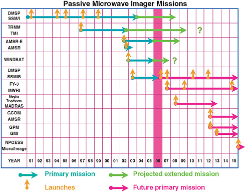
FIGURE 1.2 Duration of primary missions of spaceborne passive microwave imagers and their potential extensions (see Appendix E for explanations of program acronyms). Question marks indicate the possibility of additional extensions beyond the projected extension. Future missions are subject to change.
nese Global Change Observing Mission, the French-Indian Megha Tropique mission, the Chinese Fengyun-3 mission, and the European GPM mission (considered unlikely). The GPM constellation may also include geosynchronous imagers and microwave sounders.
Some of these constellation satellites will be launched prior to the core satellite (Figure 1.2), and some also would overlap with missions that form the present constellation of passive microwave imagers (Figure 1.2). The fortuitous overlap of DMSP operational sensors with research sensors in the last decade (i.e., TRMM Microwave Imager, Advanced Microwave Scanning Radiometer for the Earth Observing System [AMSR-E], and WindSat) has resulted in combined access to up to seven passive microwave sensors in near real time. This de facto passive microwave constellation represents a “golden era” of microwave precipitation sensing (because uncertainties in some of the planned missions mean that there will likely be fewer sensors in space when the GPM core satellite is launched). This present suite of operational and research sensors serves as an excellent testbed for GPM application discussion, planning, and demonstrations. In addition, the extension of TRMM and the existence of CloudSat and the A-Train means that a GPM-like constellation—complete with a core, radar-carrying satellite with paired microwave sensors—already exists for both the tropics and the mid to high latitudes. This provides NOAA and NASA with a unique and unprecedented opportunity to plan and carry out effective transitions early in their GPM collaboration. If TRMM and GPM overlap, the TRMM Microwave Imager would be an additional member of the GPM constellation. In addition, cross-calibration of the TRMM and GPM systems would be possible, and TRMM’s climatological time series that began in 1997 would continue with no data gaps into the GPM era.
The GPM Precipitation Processing System
The GPM Precipitation Processing System will serve as the rapid science data-processing facility for precipitation missions within NASA and partner institutions. It will be capable of producing global precipitation data products from the diverse sensors and sources that are provided by NASA and cooperative international partners.
The International Ground Validation Research Program
In conjunction with the cross-calibration of the constellation instruments and the core satellite, the overall strategy for the GPM calibration and validation program will involve a ground validation program. This program will characterize errors, quantify measurement uncertainty, and provide a measurement standard against which to assess performance and aid in the improvement of the
retrieval algorithms. A global ground validation network is necessary because of the variability in the types of precipitation (effects of precipitation type, topography, latitude, etc.). A global distribution of cooperative international sites is planned to provide the ground measurements required for calibration (Bidwell et al., 2004; Flaming, 2004).
Three types of ground validation sites are planned (Hou, 2005): (1) surface precipitation statistical validation sites for direct assessment of GPM satellite data products, (2) precipitation process sites for improving understanding and modeling of precipitation physics in physical and radiance spaces for satellite retrieval algorithm improvements, and (3) integrated hydrological sites for improving hydrological applications.
THREE PHASES OF THE GPM MISSION
The GPM mission time line can be separated into three phases (Figure 1.3). The pre-launch phase runs from the present up to the launch date of the GPM core satellite (currently scheduled for 2013). The post-launch phase runs from the launch date of the core satellite until NOAA takes it over from NASA (5 years after launch, in approximately 2018). The potential NOAA takeover phase runs from NOAA takeover of the core satellite until its instruments fail or fuel is depleted. NOAA may operate the GPM core satellite during this third phase
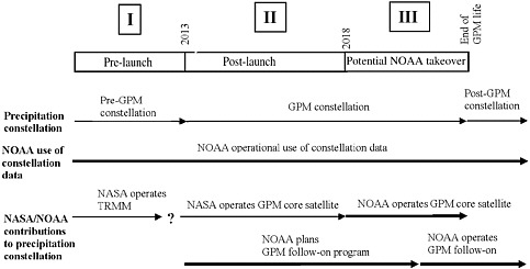
FIGURE 1.3 The three phases of GPM and how they relate to the broader context of NOAA and NASA activities and to the constellation of satellites that already contribute to global precipitation estimates. Time advances from left to right. Thick arrows indicate periods of NOAA involvement.
(Dittberner, 2006) as well as plan and operate a GPM follow-on mission that overlaps with the GPM core satellite. As of the publication of this report, the design specifications could change to allow more fuel to be carried on the core satellite for the possibility of a longer mission. As shown in Figure 1.3, there are roles for NASA and NOAA in all three phases of the GPM mission. The concept of a strategic plan for NOAA’s involvement in GPM (Chapter 5) is organized around this same three-phase framework.
GPM AS A PROTOTYPE FOR THE GLOBAL EARTH OBSERVATION SYSTEM OF SYSTEMS
GPM is conceived as a prototype for the emerging Global Earth Observation System of Systems (GEOSS) (Hou, 2005). GEOSS is an international initiative (Box 1.3) aimed at integrating information from numerous Earth-observing systems to improve understanding of processes and linkages and, in turn, enable the public, private sector, and governments to make more informed decisions across a broad spectrum of natural systems. Space-based observations are the backbone of GEOSS (Lautenbacher, 2006).
To achieve an integrated information-based system that meets the societal objectives of GEOSS, satellites systems such as GPM are needed to provide observations with adequate temporal and spatial resolution covering Earth.
|
BOX 1.3 The Global Earth Observation System of Systems (GEOSS) Partnership In response to the need for improved access to environmental information, more than 60 countries have endorsed a 10-year plan to develop and implement GEOSS. Nearly 40 international organizations also support the plans. GEOSS has identified nine societal benefit categories in which an integrated and coordinated system of Earth-observing networks would provide help. These categories are disasters, health, energy, climate, water, weather, ecosystems, agriculture, and biodiversity. Commenting in 2005 on the 10-year strategic plan for the U.S. component of GEOSS, John Marburger, director of the White House Office of Science and Technology Policy and presidential science adviser, stated: GEOSS will allow scientists and policy makers in many different countries to design, implement and operate integrated Earth-observing systems in a compatible, value-enhancing way. It will link existing satellites, buoys, weather stations, and other observing instruments that are already demonstrating value around the globe and support the development of new observational capabilities where required. SOURCE: NSTC, 2005. |
SUMMARY
The GPM mission has four functional components (the core satellite, the constellation satellites, the precipitation processing system, and the international ground validation program) that are the result of an international, collaborative effort to expand capabilities for global, space-based precipitation measurements. GPM activities at NOAA and NASA will occur over the three phases of the mission: the pre-launch phase, the post-launch phase, and the potential NOAA-takeover phase. The GPM mission is a prototype for the international GEOSS initiative, which will require an integrated, intercalibration system for space-based instruments. The following chapters provide a framework for NOAA activities—both within the agency and with agency partners—during the three phases of the GPM mission.


