
Summary
Continuous and reliable global precipitation information is crucial for myriad applications ranging from weather to climate, such as flood forecasting, understanding the inner workings of hurricanes and other storm systems, and tracking long-term trends in water supply. Measuring precipitation is, however, one of the more difficult observational challenges of meteorology because the phenomenon occurs with pronounced geographic and temporal variability. In conjunction with comprehensive, accurate ground validation and calibration, satellite observations offer the only realistic prospect for accurate and semicontinuous global precipitation data sets, especially over the oceans and in remote regions. Building on the progress from three decades of measuring or inferring precipitation from space—most recently with advances made by the Tropical Rainfall Measuring Mission (TRMM)—the upcoming Global Precipitation Measurement (GPM) mission represents the next generation of measurement capability for meeting the mission requirements at the National Oceanic and Atmospheric Administration (NOAA) for global precipitation data (NOAA, 2002).
This report offers analysis and recommendations to facilitate effective operational use of this next-generation precipitation measurement capability. At NOAA’s request, the National Research Council’s Committee on the Future of Rainfall Measuring Missions1 was tasked to answer the following questions:
-
What lessons were learned from TRMM with respect to operational uses of the data, and how can these lessons enhance the use of GPM mission data and other National Aeronautics and Space Administration (NASA) research mission data in NOAA operational forecasts?
-
What are the best uses for GPM data in an operational environment such as in NOAA?
-
How can NOAA ensure that its operational forecast models, forecasters, and product users are ready for GPM data as soon as possible after launch?
The GPM mission is a cooperative effort of NASA, the Japan Aerospace Exploration Agency (JAXA), NOAA, and other U.S. and international agencies and institutions.2 The mission includes a core satellite that makes measurements between 65 degrees latitude North and South and carries a dual-frequency precipitation radar and a passive microwave sensor. The data from this satellite are to be intercalibrated with those from a constellation of other satellites carrying similar microwave sensors to provide global estimates of precipitation approximately every 3 hours. NASA conceives the GPM mission as a prototype for the Global Earth Observation System of Systems (GEOSS)—an international initiative for integrating data from numerous Earth-observing systems with similarities to the international and collaborative efforts of the GPM mission.
The GPM mission time line can be separated into three phases: the pre-launch phase runs from present to the launch date for the GPM core satellite (scheduled for 2013); the post-launch phase runs until NOAA potentially takes over operation of the core satellite from NASA (proposed for 5 years after launch, in approximately 2018); and the potential NOAA takeover phase then runs until the instruments fail on the core satellite or until fuel is depleted. NOAA has already indicated interest in the concept of this third phase, as well as the possibility of an operational GPM follow-on mission that overlaps with the GPM mission. As of the publication of this report, the design specifications could change to allow more fuel to be carried on the core satellite for the possibility of a longer mission.
Some of the constellation satellites will be launched prior to the GPM core satellite (Figure S.1), and some also will overlap with missions that form the present constellation of passive microwave sensors. The present-day, de facto passive microwave constellation represents a “golden era” of microwave precipitation sensing because the number of constellation satellites is likely to be small-
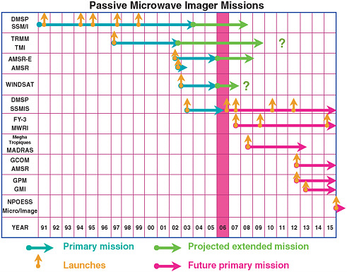
FIGURE S.1 Duration of primary missions of spaceborne passive microwave imagers and their potential extensions (see Appendix E for explanations of program acronyms). Question marks indicate the possibility of additional extensions beyond the projected extension. Future missions are subject to change.
er in the GPM era and the composition of the constellation is still unclear. The present constellation includes a suite of operational and research sensors that serve as an excellent testbed for discussion, planning, and demonstrations of GPM applications. In addition, the extension of TRMM to at least 2009 means that a GPM-like constellation already exists because there is already a core satellite (albeit with a more limited geographic coverage) carrying both a microwave radiometer and a precipitation radar. This provides NOAA and NASA with a superb opportunity to plan and carry out effective transitions early in their GPM collaboration and to test and refine methodologies in advance of the GPM core satellite launch. Such methodologies will help NOAA bridge the gap between its operational requirements and current measurement capabilities. The kinds of applications for which these (and, subsequently, GPM) data will be particularly valuable are numerical weather prediction (through improved data assimilation and moist physics approaches); monitoring tropical cyclones and severe storms; flash flood forecasting; calibrating ground-based precipitation networks; improv-
ing high-resolution, global precipitation analyses; and extending precipitation climatology (beyond the record started by TRMM) and climate data records of global precipitation.
LESSONS LEARNED FROM TRMM
Lessons learned from TRMM will guide observational and research aspects of the GPM mission, effective transition of GPM data and results to operational use, and partnership among NOAA, NASA, and other U.S. and international agencies and institutions. The overarching technological lesson of TRMM was its demonstration that inferring precipitation from space is sound. TRMM demonstrated the robustness, high endurance, and general feasibility of paired radar and passive microwave systems in space as well as the value of precipitation radar for observing the fine-scale, three-dimensional structure of precipitating weather systems. In addition, TRMM demonstrated the value of a multisensor reference satellite for calibrating data from other space-based observational systems and the feasibility of obtaining near-real-time global coverage of precipitation observations from space. Conversely, TRMM showed the difficulties of direct validation of its precipitation measurements using surface measurements but pointed the way toward better approaches in the GPM era. In general, TRMM is an example of unexpected “bonuses” often accruing from a scientific mission, and it was a model for international cooperation in pursuing a remote-sensing initiative.
TRMM generated a number of lessons that will improve planning for operational use of GPM data. The TRMM experience demonstrated that operational application of research data can be hampered if the mission has no specific application goals, no pre-launch planning for operational exploitation of the data, and uncertainty regarding the post-launch phase.
Lessons learned from the absence of such planning for TRMM have stimulated informal, pre-launch planning by NOAA for operational exploitation of GPM data. In addition, NOAA is participating in multiple, joint NASA-NOAA planning activities, namely, the NOAA-NASA GPM Research and Operations Group, NOAA participation on the NASA Precipitation Measurement Missions science team, the Joint Center for Satellite Data Assimilation (JCSDA), and the International Precipitation Working Group (IPWG). However, NOAA’s participation in these partnering activities is ad hoc, lacking in formal funding, or outside of NOAA’s control. These factors limit NOAA’s ability to formally engage in GPM planning.
Given NOAA’s interest in the concept of operating the GPM mission after the NASA post-launch phase and the value it will derive from GPM data in earlier stages of the mission, there is a need for more formal planning and involvement by NOAA. The Geostationary Operational Environmental Satellite-R
(GOES-R) Risk Reduction plan,3 for example, includes preparations to reduce the risk of not being ready to use data once GOES-R is launched and fully functional, and to provide state-of-the-art software and algorithms to derive products from the data once they become available. This plan could serve as a model for many elements of NOAA’s preparations for the GPM mission.
Recommendation: As soon as possible, NOAA should formalize its GPM planning by developing a comprehensive, coordinated, agency-wide strategic plan for activities in all three phases of the GPM mission. In addition, NOAA and NASA should determine their respective roles and responsibilities in all three phases. (Relates to Recommendations 2.1, 3.1, 3.2, 4.3, 4.4, 4.5, and 5.2)
Recommendation: NOAA should consider the GOES-R strategic readiness approach as a model for aspects of its GPM strategic plan. (Recommendation 5.1)
Recommendation: NOAA should formally support the NOAA-NASA GPM Research and Operations Group, the NASA Precipitation Measurement Missions (PMM) science team, JCSDA, and IPWG through the establishment of a NOAA steering group on space-based precipitation missions, through direct support of these partnership activities, and/or through support of individual NOAA scientists. The NOAA steering group on space-based precipitation missions should serve as a focal point at NOAA to coordinate GPM partnership activities with NASA and should oversee implementation of the GPM strategic plan recommended by this committee. (Relates to Recommendations 3.3, 3.4, 3.6, 4.1, 4.2, 4.6, and 4.7)
BEST USES OF GPM DATA AT NOAA
To identify the best uses of GPM mission data at NOAA, the committee examines NOAA mission requirements for precipitation data and related products. Next, the committee identifies current sources and applications of NOAA operational precipitation data and recommends improvements in preparation for GPM. The best operational uses of GPM data at NOAA will be weather forecasting, hydrologic applications, climate applications, and global precipitation climate data records.
PREPARATIONS FOR THE GPM MISSION AND BEYOND
The committee identified 11 areas of activity for NOAA’s preparations for the GPM mission: (1) NASA-NOAA cooperative research and development, (2) data exchange, (3) intercalibration, (4) ground validation support, (5) data product development, (6) data archiving and distribution, (7) infusion of new technology, (8) data assimilation, (9) model physics development, (10) data impact evaluation, and (11) user education and training. In addition to the concepts and actions that NOAA has already expressed interest in pursuing (e.g., GPM follow-on activities), the committee recommends additional, detailed guidance for activities in preparation for the GPM mission. These activities and recommendations are listed within the three-phase framework of the GPM mission (Table S.1). Because the committee’s third task focuses on the pre-launch phase of the GPM mission, many of the recommendations in Table S.1 are listed under the pre-launch phase.
The transition of the GPM mission from a research program to an operational system will have to be designed to ensure continued acquisition and application of high-quality, intercalibrated global satellite-based precipitation observations in support of NOAA’s mission-oriented forecasting operations and climate services. This will involve four areas of effort: (1) GPM core satellite and constellation satellites, (2) continuation of an intercalibration program, (3) continuation and expansion of an international ground validation program, and (4) development of a suite of data and data products.
Recommendation: NOAA’s strategic planning for GPM should address the need for the development and implementation of operational versions of the four basic components of the GPM research program.
Although the future state of operational global precipitation measurements is unclear, NOAA has the opportunity to lead and catalyze development of an operational precipitation measurement network in addition to supporting and working on the next-generation observational efforts that are planned for the GPM mission. NOAA’s resources could be directed at many activities that will help in this regard (Table S.1), and the present constellation of passive microwave sensors in conjunction with TRMM’s unique suite of sensors provides an ideal source of global, intercalibrated data with which to refine operational applications in preparation for future precipitation-measuring missions.
TABLE S.1 Proposed NOAA Activities During Pre-launch, Post-launch, and Potential NOAA-Takeover Phases of the GPM Mission
|
Phase |
Category of Activity |
Action |
|
Pre-launch |
Initiation and participation |
|
|
Phase |
Category of Activity |
Action |
|
|
|
|
|
Phase |
Category of Activity |
Action |
|
|
|
|
|
|
Planning and preparatory |
|
|
Post-launch |
Initiation and participation |
|
|
Phase |
Category of Activity |
Action |
|
|
Planning and preparatory |
|
|
Potential NOAA takeover |
Initiation and participation |
|
|
NOTE: These activities are discussed in Chapters 3, 4, and 5 of this report; activities associated with a specific committee recommendation are listed in boldface type. aEach recommendation in the chapters of this report is assigned a reference number. The first digit of the reference number corresponds to the chapter in which the recommendation appears (Chapter 2, 3, 4, or 5). The second digit of the reference number corresponds to the sequential order in which the recommendation appears within its chapter. |
||


