
3
Precipitation Data in NOAA Operations
This chapter describes the needs, capabilities, and potential opportunities of the National Oceanic and Atmospheric Administration (NOAA) for using space-based precipitation estimates. To identify the best uses of Global Precipitation Measurement (GPM) mission data at NOAA, the committee first examines NOAA mission requirements for precipitation data and related products. Next, the committee identifies current sources of NOAA operational precipitation data and recommends improvements for these sources in preparation for GPM. Next, five challenges are identified for future space-based precipitation missions. Finally, this chapter outlines the applications of space-based precipitation data in general and the potential applications of GPM mission data specifically.
NOAA MISSION REQUIREMENTS FOR PRECIPITATION DATA AND RELATED PRODUCTS
Global observation of precipitation on a range of time and space scales is essential to achieving NOAA’s mission objectives related to the monitoring and prediction of weather, climate monitoring, many aspects of hydrologic monitoring and prediction, climate data set development, and more (Box 3.1). NOAA maintains or contributes to a wide variety of in situ and satellite-based precipitation measurement systems in support of its mission and the World Meteorological Organization (WMO) World Weather Watch. Because precipitation crosscuts many applications, NOAA’s production, application, dissemination, and archiving activities associated with precipitation data are carried out at multiple centers. NOAA requirements for precipitation data were reviewed at a 2001
|
BOX 3.1 NOAA’s Five Primary Mission Goals
SOURCE: NOAA, 2004. |
workshop (NOAA, 2002), and these requirements are discussed in more detail in the following sections.
Requirements for Weather Applications
The critical requirement for weather-related applications is timely and continuous availability of accurate precipitation data transmitted in WMO formats. NOAA weather-related activities requiring precipitation data include nowcasting (0-3 hours lead time); short-term forecasting (3-12 hours), multiday numerical weather prediction (NWP) forecasts, and preparation and dissemination of centralized forecast guidance.
Many of NOAA’s weather-related (and climate-related) operational activities are centered in the National Centers for Environmental Prediction (NCEP). NCEP’s operational needs for global precipitation data include initialization of atmospheric and surface hydrologic (soil moisture) components of coupled NWP models and forecast verification. NCEP’s Environmental Modeling Center needs data describing precipitation characteristics, processes (e.g., phase, type, vertical distribution), and ambient conditions (e.g., temperature, humidity, winds) for improving model physics and data assimilation methodology. NCEP central operations provide services in the form of centralized forecast guidance and analysis products that support the public use of NCEP’s National Weather Service (NWS) forecasts. These products, which include precipitation forecasts, are delivered through the NCEP Hydrometeorological Prediction Center (heavy precipitation forecasts), Storm Prediction Center (severe weather forecasts), Tropical Prediction Center (tropical cyclone forecasts), and Aviation Weather Center. Frequent sampling and timely data availability are also critical for precipitation nowcasts and short-term projections prepared by the National Environmental Satellite, Data, and Information Service (NESDIS) Satellite Analysis Branch.
Requirements for Climate Applications
NOAA’s climate-related requirements for precipitation data are similar to requirements for weather-related activities with three exceptions: (1) the requirements for timely receipt of precipitation data for operational purposes are generally less stringent, (2) there are more stringent requirements for absolute accuracy, and (3) there is a fundamental need for long, stable, and consistent precipitation time series. NOAA climate-related operational activities require precipitation data for monitoring, diagnosis, and prediction of short-term (seasonal to interannual) climate variability. Precipitation data are also required for climate data set development and for mission-oriented research on climate variability, diagnosis of climate trends, and modeling of climate change.
The NCEP Climate Prediction Center provides near-real-time monitoring, assessment, and projections of seasonal-interannual climate variability for use by U.S. agencies with national and international interests, United Nations agencies (Food and Agricultural Organization, WMO), and the public. The Climate Prediction Center’s satellite-based, high-resolution morphing technique (CMORPH) for global precipitation analysis is a key tool for supporting the Climate Prediction Center’s monitoring and diagnostic activities.
The NOAA Climate Diagnostic Center requires precipitation data to support its mission of providing diagnostic information on the nature and causes of climate variations, with the goal of predicting these variations.
The NOAA Climate Program Office is a focal point for many climate activities within NOAA. The Climate Program Office supports several projects dealing with the development and use of satellite precipitation data sets. These projects include the Climate Change and Detection Project, the Applied Research Center for Data Set Development for transition of Climate Change and Detection Data Projects to NOAA operations, and the Scientific Data Stewardship Program, which governs the production of climate data records.
Requirements for Hydrologic Applications
Surface hydrology requirements for precipitation data intersect weather and climate needs. They include flash flood forecasts and warnings, monitoring and assessing the impact of drought (e.g., fire risks, crop yields, river stage forecasts), monitoring and predicting runoff from the snow pack in the western United States (which is of paramount importance for water resource management), and other hydrologic information from NOAA’s 13 River Forecast Centers.

FIGURE 3.1 Duration of spaceborne, geosynchronous imager missions and their potential extensions (explanations of program name abbreviations are found in the “Visible and Infrared” section later in this chapter). Future missions are subject to change.
NOAA’s Ability to Fulfill Its Precipitation Measurement Requirements
Increasingly comprehensive and higher-quality satellite precipitation data and data products have become available during the past several years as a consequence of the launch of the Tropical Rainfall Measuring Mission (TRMM) and a number of polar-orbiting satellites carrying passive microwave sensors. Despite these advances, NOAA’s requirements for global precipitation data continue to exceed what is available (NOAA, 2002), and each of the primary sources of space-based precipitation information has different strengths and weaknesses (see Figure 1.2 and Figure 3.1) with respect to fulfilling these data needs. At NOAA’s precipitation workshop in 2001, participants identified NOAA’s requirements that would not be met by existing or planned systems (NOAA, 2002). The deficiencies in space-based observations that were identified can be summarized into three broad categories:
-
data quality and consistency and quantitative description of error characteristics,
-
time and space resolution, and
-
timely availability for operational use.
Participants reached the conclusion that to mitigate the deficiencies noted in their report, “substantial improvements in this information are necessary to advance beyond our present capabilities” (NOAA, 2002). Some of the deficiencies have now been mitigated (e.g., higher-resolution global analyses have been developed [in prototype] by combining information from polar-orbiting passive microwave and geosynchronous infrared observations [see Figure 1.2 and Figure 3.1]), but for the most part the deficiencies still exist. The workshop report recognized that many of the existing deficiencies can be significantly mitigated by GPM (see NOAA, 2002, Finding 6 and Recommendation 1). Finding 6 in the workshop report states: “The proposed NASA/Global Precipitation Mission would provide data that would greatly improve NOAA’s ability to monitor and predict weather and climate variability” (NOAA, 2002). Recommendation 1 states: “NOAA should become an active partner with NASA [National Aeronautics and Space Administration] in the Global Precipitation Mission. This system will provide the global three hourly precipitation estimates required by the operational modeling centers. Furthermore, significant improvements in precipitation information for nowcasting, extreme precipitation events, and flash floods will be achieved when geostationary data, gauges, and radars are combined with GPM. Consideration should be given to the establishment of a science team or working group that would define NOAA’s role in and relationship to GPM” (NOAA, 2002).
SOURCES OF NOAA OPERATIONAL PRECIPITATION DATA
There are two primary sources of operational precipitation data: ground-based observation systems and space-based observation systems. As the GPM core and constellation satellites supplement these sources, they will benefit from being validated against data from a robust ground-based network. This section reviews the status and attributes of ground-based and satellite sources and makes recommendations for improvements that will benefit GPM in particular and global precipitation estimation in general.
Ground-Based Sources
The continental United States is instrumented with a variety of rain gauges and weather radars that measure precipitation. Both sources have a variety of spatial and temporal sampling approaches that depend on domain and precipitation type.
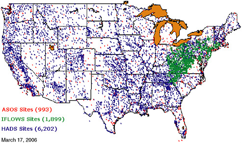
FIGURE 3.2 Distribution of rain gauge data available to NOAA in near real time from three networks: ASOS sites (red), IFLOWS (green), and HADS sites (blue). SOURCE: NWS, 2006a,b,c.
Rain Gauge Data
Rain gauge data for NWS operations in the continental United States come from multiple agencies in a cooperative network that combines the physical resources of these agencies and is facilitated by good communication links and automation software. The data from these multiple sources undergo quality control and are incorporated in near real time to form an extensive rainfall database. The data are analyzed to map precipitation distribution, determine the potential extent of flooding, and calibrate and validate radar and satellite precipitation estimates.
The following observation networks contribute to NOAA operations: (1) the automated surface observing system (ASOS), (2) the Integrated Flood Observing and Warning System (IFLOWS), and (3) the Hydrometeorological Automated Data System (HADS) (Figure 3.2). The HADS data set comes from a number of agencies (Table 3.1).
In addition to the three networks mentioned above, data sets from local, state, and federal cooperative efforts, known as “mesonets,” are integrated into near-real-time data streams that feed NOAA operations. As additional sensors are connected into these mesonets through upgraded data links and become accessible on the Internet, further opportunities will emerge from multiagency partnerships that tap into mesonets and observing systems.
TABLE 3.1 Rain Gauge Networks in the Hydrometeorological Automated Data System
Whereas rain gauge data are extensive in some regions, nonuniform gauge placement (e.g., Figure 3.2) creates sampling problems such as biases (Sevruk, 1989). In addition, rain gauge measurements have inherent inaccuracies that must be addressed before these data can contribute to the overall precipitation mapping mission (Steiner et al., 1999). Rain gauge data are often treated as “surface truth,” but comparisons with rainfall estimates from radar and satellite rain estimates remain uneven due to these sampling inconsistencies and inaccuracies.
Finding: In collaboration with other agencies, NOAA maintains an extensive rain gauge network that provides data in near real time that will contribute to GPM’s calibration and validation efforts. The value of this network to such efforts will be enhanced as data links are upgraded and new mesonets and observing systems become more accessible with rigorous quality control.
Recommendation 3.1: NOAA should explore collaborative efforts to augment the existing rain gauge network with additional resources coming online through mesonets that are increasingly used by local, state, and federal agencies to quantify precipitation for many near-real-time applications. NOAA should maintain rigorous quality control and integrate the resultant rain gauge data sets into GPM calibration and validation efforts.
Radar Data
The NWS operates an extensive network of real-time radar (Weather Surveillance Radar 88 Doppler [WSR-88D] Next Generation Radar [NEXRAD])
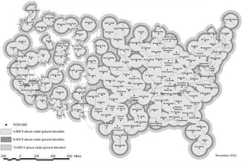
sites (Figure 3.3) around the continental United States, Alaska, Hawaii, Guam, and Puerto Rico that are used in concert with rain gauge data to map precipitation. The NEXRAD network provides near-real-time rain totals (with updates every 6 minutes) that aid in issuing flood watch and warning nowcasts and forecasts. The network’s ability to fully automate the retrieval process and quickly communicate the digital values throughout a region and across the continental United States is of particular value to the NWS River Forecasting Centers.
Real-time radar rain estimates are especially good in the eastern two-thirds of the United States, where terrain blockage issues are infrequent (Maddox et al., 2002). Real-time rain measurements permit emergency managers to respond quickly. Combined radar and rain gauge values enable creation of enhanced data sets benefiting multiple user communities (e.g., flood control, agriculture, transportation). NEXRAD data are crucial during rapidly evolving summer thunderstorm events as well as for prolonged and extreme events such as landfalling tropical cyclones.
In addition to the positive attributes of the NEXRAD network, it has some shortcomings due to terrain blockage in mountainous areas (Figure 3.3); inability to capture low-level rain because the radar beam rises with distance from the radar site; lack of uniformity of the reflectivity versus rain rate relationship from
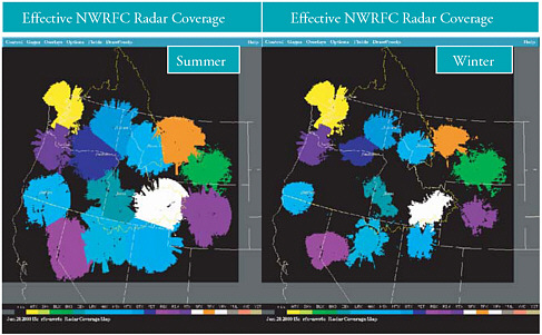
FIGURE 3.4 Change in effective NEXRAD radar coverage in the western continental United States due to wintertime precipitation and high terrain (right panel) compared with summertime coverage (left panel) when convection and associated higher cloud tops enhance the spatial sampling. SOURCE: Kondragunta, 2005.
one location to another and over time; difficulty with mixed-phase and frozen precipitation; decreased wintertime radar coverage in the western United States because low-level precipitation dominates during the winter (Figure 3.4); and data interruptions during extreme events such as hurricanes due to power or communications going offline.
The shortcoming related to interruptions can be reduced by upgrading communications systems and building in greater redundancy. The drawback related to accuracy of rain rate estimates can be mitigated by removing biases via TRMM-like precipitation radars (Anagnostou et al., 2001) and by deploying dual-polarization radar (Bringi and Chandrasekar, 2001; Ryzhkov et al., 2005). In addition, some of the shortcomings of ground-based sources in general will be mitigated by higher-fidelity satellite precipitation estimates.
Finding: NWS radar precipitation mapping provides critical real-time monitoring and forecasting capabilities that support many NOAA functions and offices. In addition, this data source will be invaluable to GPM calibration and validation efforts. However, the radar network suffers from a number of shortcomings with respect to accuracy and spatial and temporal coverage that can be ameliorated with radar and power upgrades and increased communications redundancy.
Recommendation 3.2: NWS should proceed with upgrading the NEXRAD network with dual-polarization radar and should enhance network reliability with upgraded power and communication redundancy. NOAA should integrate NEXRAD data sets into GPM calibration and validation efforts.
Satellite Sources
Satellite sensors mitigate several weaknesses in rain gauge and ground-based radar data sets; thus, the combination of gauge, radar, and satellite precipitation data provides a powerful tool for multiple applications. For example, space-based sensors sample areas where in situ precipitation observations are absent. In addition, they supplement in situ observations in regions where ground-based sites are sparse (most polar-orbiting passive microwave sensors view a swath that spans the equivalent of three to five NEXRAD radar coverages optimally arranged along a satellite path). Furthermore, satellite observations can delineate areas where no precipitation is falling over vast oceanic regions and merged infrared-microwave products have high temporal refresh. Lastly, geostationary imagers can capture data at a rate that is sufficient to monitor vigorous convective activity (imagers view the entire continental United States every 15 to 30
minutes with spatial resolutions of 4 to 8 km at nadir,1 and when operated in “rapid scan” mode, these imagers capture snapshots [over a smaller spatial domain] as frequently as each minute). NOAA’s two major sources of space-based precipitation information are visible and infrared data from geostationary satellites and passive microwave data from polar-orbiting satellites.
Visible and Infrared
Visible and infrared imagery first became available from satellites in the mid 1960s. The approach to inferring precipitation from these observations was initially centered on indirect (or “proxy”) techniques that relate visible and/or infrared observations of brightness or temperature of cloud tops to large-scale, time-averaged convective rainfall amounts over the global tropics (Arkin, 1979). Thus, although colder cloud tops imply relatively higher cloud tops and the potential for heavier rainfall, the correlation is often poor and varies considerably with time, location, and precipitation regime (e.g., convective or stratiform). However, the wealth of high-quality (1-4 km nadir spatial resolution) geostationary visible-infrared data and the frequent temporal sampling (15-30 minutes over the continental United States) are key ingredients for precipitation monitoring. Although cloud-top temperatures, cloud-top heights, and cloud type are not highly correlated with instantaneous rain rates, the correlation is strongest for warm-season convective systems that frequent the eastern and midwestern continental United States.
Operational geostationary visible-infrared digital data sets cover the globe between 60 degrees latitude North and South and are routinely available for near-real-time applications. The geostationary constellation is an international collaboration in which very large data sets are exchanged under the auspices of the World Meteorological Organization. This constellation includes Meteosat-8 (Meteorological Satellite 8; 0° E, European Organisation for the Exploitation of Meteorological Satellites [EUMETSAT]2 ), Meteosat-5 (63° E, EUMETSAT), INSAT (Indian National Satellite; 74° E, India), FY-2 (Fengyun-2; 105° E, China), MTSAT/GMS-6 (Multi-Functional Transport Satellite/Geostationary Meteorological Satellite; 140° E, Japan Meteorological Agency), GOES-West (Geostationary Operational Environmental Satellite-West; 135° W, United States) and GOES-East (75° W, United States). Figure 3.1 shows geostationary sensors and their data availability since 1995. Due to sensor evolution and specific country preferences, no two sensors are identical with respect to available channels or spatial and temporal sampling.
All geostationary visible-infrared imagers include a minimum of one visible
channel and multiple infrared bands that can be used for identifying clouds, mapping cloud-top temperatures, and in many cases, assisting in determining cloud type using various cloud classification schemes. Most clouds between 60 degrees latitude North and South are resolved throughout the day.
Geostationary sensors have evolved due to each country’s efforts to provide sorely needed operational weather and environmental information within its regional domain as noted in Figure 3.1. Note that the current configuration has complete global coverage at the equator and in many cases overlap between consecutive satellite sensors. In addition, spare geostationary sensors from one country have been successfully “loaned” to other WMO members when hardware “glitches” limit sensor availability (EUMETSAT has helped the United States, and the United States has helped Japan). The “health” of the global geostationary constellation is at an all-time high, and this coverage has now reached the level of maturity required for routine “blended” algorithms that combine the best of geostationary visible-infrared and the more infrequent passive microwave imager polar orbiter data sets.
Microwave
The first Special Sensor Microwave/Imager (SSMI) was launched in 1987 as part of the continuing series of operational, polar-orbiting Defense Meteorological Satellite Program (DMSP) satellites operated by the Department of Defense (DOD). The sensor provided the first operational passive microwave data (Hollinger, 1989) for developing and applying more physically based algorithms that draw on direct measurements of the natural irradiative properties of precipitation particles. The temporal sampling of passive microwave data has improved as the DMSP constellation has been supplemented with new satellites (Figure 1.2). Three such satellites are now operational. In addition, the SSMI sensors have been upgraded with the Special Sensor Microwave Imager Sounder (SSMIS), launched in 2003 (Wessel et al., 2004).
The SSMIs have been augmented with research sensors carried on NASA platforms. For example, TRMM provided both the TRMM Microwave Imager and Precipitation Radar, launched in 1997. TRMM was followed by the Advanced Microwave Scanning Radiometer for the Earth Observing System (AMSR-E) on Aqua in 2002. Both the TRMM Microwave Imager and AMSR-E have rain-sensitive frequencies (Kummerow et al., 2000; Wilheit et al., 2003) and higher spatial resolution for mapping finer-scale rain-causing cloud systems than the SSMI or SSMIS. In 2003, the Navy launched the Coriolis WindSat polarimetric radiometer (Gaiser et al., 2004) as a Conical Scanning Microwave Imager Sounder (CMIS) risk reduction sensor.3 Although WindSat’s primary
mission is to test wind vector retrieval using microwave radiometry, it has frequencies similar to the TRMM Microwave Imager and AMSR-E for precipitation estimates.
Rain rates can also be retrieved using microwave sounder data in addition to the imager data described above (i.e., SSMI and SSMIS). For example, the Advanced Microwave Sounding Unit B (AMSU-B), which is used operationally to measure atmospheric moisture, also has channels that can extract rain rates across the sensor’s 2,300 km swath (Weng et al., 2003). Unfortunately, fluctuations in cross-track resolution make AMSU-B imperfect as a source of microwave rain rate estimates. However, the broad swath and availability of three operational AMSU-B sensors help mitigate these temporal sampling problems. AMSU-B data are now complemented by the Microwave Humidity Sensor (MHS) on board recently launched NOAA-18 and will follow shortly on METOP-1 as noted later.
The CloudSat mission flies the first millimeter-wavelength radar system that observes both clouds and precipitation. CloudSat flies in formation with Aqua, thereby providing a near-simultaneous set of radar observations and passive microwave observations of AMSR-E. Methods to derive precipitation information using this combination of radar and passive microwave observations have been developed and will continue to evolve. CloudSat radar observations are also viewed as an important contribution to the measurement of snowfall, and snow-related research activities are currently being formulated around these new observations (Bennartz and Ferraro, 2005).
Planned Satellite Precipitation and Related Missions That Contribute to the Global Precipitation Constellation
In general, the geostationary constellation health will markedly improve in the next 5 years, while the opposite is true for passive microwave imagers on low-orbiting platforms. Also, microwave sounders will remain on both U.S. and EUMETSAT polar orbiter platforms and provide rainrate data sets. A wealth of geostationary visible-infrared sensors are planned over the next 10 years, as noted in Figure 3.1, that will assist in “blended” precipitation estimates. In addition to new satellites in the GOES, Meteosat, INSAT, FY-2, and GMS series, both Korea and Russia will join the geostationary satellite community with new entries that will provide enhanced data continuity and/or spatial resolution for specific areas now viewed at large viewing angles with existing satellite sensors. Potential issues still remain if specific problems occur with the launch or operations of individual satellites, but the ability to mitigate hardware flareups can be resolved more easily with this overlapping constellation configuration.
It should be noted that all geostationary member satellites are rapidly approaching the inclusion of visible-infrared and water-vapor channels and 10-bit digitization as the standard suite of instruments. These instruments will greatly aid precipitation applications and provide standardization across the globe that will enhance global precipitation continuity.
In addition to plans for the GPM core satellite, a number of complementary missions are planned in the United States and internationally (Figure 1.2) that contribute to the constellation of opportunity needed to maximize the coverage and refresh rate of the GPM mission data retrievals. Such a constellation already exists (Figure 1.2) and even has a core satellite with a precipitation radar instrument (TRMM) and a precipitation-capable radar for measuring snow in higher latitudes and light precipitation (CloudSat). However, these capabilities are short term (scheduled to end operation before the launch of the GPM core satellite), and there is uncertainty surrounding planned missions beyond the end of these missions. It is unclear how the constellation will evolve over the GPM time frame.
The GPM mission is currently slated to include two satellites: (1) the core satellite with dual-frequency precipitation radar and microwave imager sensors, and (2) a free flyer with another microwave imager sensor. Although orbital characteristics are not final, options include a TRMM-like low-latitude inclination that would permit both a continuation of diurnal rainfall monitoring and frequent overpasses for tropical cyclone applications globally. In addition, the low inclination will provide frequent opportunities for cross-calibration of higher-inclination passive microwave sensors (e.g., SSMIS).
Through DMSP, DOD plans to launch four SSMIS sensors over the next 1-7 years. These will lead up to the follow-on microwave imagers onboard the NPOESS sensor suite as DOD and NOAA operations converge under the NPOESS umbrella. The 15-year NPOESS program proposes three microwave imaging sensors in a two-orbit constellation instead of the original six CMIS sensors in a three-orbit configuration. The NPOESS restructuring in June 2006 has deleted the CMIS sensor program in lieu of recompeting this sensor’s capabilities for three sensors on spacecraft C2-C4. Thus, without a C1 sensor in the year 2013, the first NPOESS microwave imager (yet to be named) will be no earlier than the C2 launch in 2016.
Although frequencies and sensor attributes are not known at this time, it is highly likely that rain products will be feasible with the three NPOESS microwave sensors. However, the reduction from six to three sensors and the current launch schedule significantly impact the global mix of microwave imagers available for precipitation monitoring. Temporal sampling will be hindered because fewer sensors equate to less frequent observations and imply that enhanced reliance will be placed on “merged or blended” precipitation techniques using both passive microwave and visible-infrared data sets. All options will directly affect the GPM constellation’s ability to meet temporal and spatial sampling and accuracy goals.
It should be noted that NPOESS data have potentially greatly enhanced data latency through the “SafetyNet” data relay system (Hoffman, 2006). The vast majority of NPOESS global digital data will be available within 30 minutes versus the current values of 1-4 hours for most polar-orbiting data today.
The rapid data availability bodes well for near-real-time merged precipitation algorithms.
Another potential U.S. contribution to the microwave constellation that is still in the discussion stage is to include a microwave imager on the next generation of operational geostationary sensor suites (GOES-R), although the earliest feasible availability is not likely until around 2020. All but one of the other planned missions discussed in this section are polar-orbiting missions, which share drawbacks of having poor data refresh rates and modest spatial resolution (due to limited antenna size and high satellite altitude). A geostationary imager would improve refresh rates. In addition, the proposed sensor would use higher frequencies than on present systems to partially mitigate spatial resolution issues.
European sensors were added to the microwave constellation with the launch of the MHS—a follow-on to AMSU-B—now operational on board the NOAA-18 satellite. More importantly, MHS is slated for the European Meteorological Operational (METOP) weather satellite series scheduled for first launch in Fall 2006, which will provide key atmospheric moisture data for the next 15 years from METOP 1 to METOP 3. METOP’s MHS will provide the midmorning orbital plane in conjunction with the NPOESS microwave imager in the early morning and afternoon orbits. Although METOP will carry a microwave moisture sounder, it will not carry a microwave imager (though future plans may include an imager starting with METOP-4). Another potential European contribution to the constellation is the proposed European Global Precipitation Measurement (EGPM) mission satellite, which would have global coverage and carry a radar in addition to a microwave imager and would target light rainfall and light-to-medium snowfall. Although this is potentially a unique and central contributor to the overall precipitation constellation, the uncertain status of EGPM and the lack of funding mean it cannot be relied on as a contributor to future precipitation measurements.
The French-Indian Megha-Tropique mission carrying the Microwave Analysis and Detection of Rain and Atmosphere Structure (MADRAS) microwave imager is planned for launch in 2008 or 2009. It will occupy a 20-degree tropical inclination (compared with TRMM’s 35-degree inclination) and provide coverage of tropical diurnal rain rates. The 20-degree inclination of the MADRAS microwave sensor on board the French-Indian Megha-Tropique mission will provide key temporal coverage not feasible from any other sensor than TRMM’s Microwave Imager. In addition, the orbit will provide many intersections with more highly inclined GPM constellation sensors and, thus, opportunities for intersensor calibration and validation. However, many near-real-time applications of data from this spacecraft may be prevented because of the plans for only three downloads per day to a single receiving station. For this sensor to contribute to the global observing system, the satellite community will need to explore options (such as incorporation of a Tracking and Data Relay Satellite System) that can provide this vital tropical sensor data set globally in near real time.
China plans to launch a multichannel Microwave Radiation Imager (MWRI) on board its FY-3A and 3B satellites in 2007 and 2009, respectively—a useful addition to the microwave radiometry efforts (Figure 1.2). China has discussed the option of flying a low-orbit precipitation mission similar in concept to TRMM with both a precipitation radar and a microwave radiometer. In addition, Japan will launch the Global Change Observing Mission (GCOM) by 2012, which combines multiple channels sensitive to rain with superb spatial resolution. This mission follows in the footsteps of the Advanced Earth Observing System program that carried the AMSR-E sensor.
Finding: Availability of the NPOESS microwave imagers in both proposed NPOESS orbits is essential to any precipitation-measuring constellation. Yet there is uncertainty about the NPOESS microwave sensor design. Changes in sensor configuration (i.e., antenna size and/or channels) or launch dates will have immediate impacts (potentially negative) on GPM mission goals (and, consequently, its contribution to GEOSS) unless these changes can be mitigated by other satellites or sensors. Without the NPOESS microwave imaging sensors, only two to five microwave imagers will be flying at any given time in the 2015-2025 period, compared to seven sensors available today (there are still unresolved global access issues for some foreign satellite data sets). These seven sensors mitigate many inherent temporal sampling issues for polar-orbiting satellites.
Recommendation 3.3: NOAA headquarters should communicate to the NPOESS program office the critical role the NPOESS microwave imagers will play as a linchpin in its GPM efforts and their contribution to GEOSS. In addition, it should communicate the ramifications to GPM and GEOSS of all NPOESS changes. NOAA’s strategic plan for GPM should include contingency plans to address the possibility of NPOESS and other microwave imager-sounder launch delays and/or sensor configuration changes.
Finding: Many near-real-time applications of data from the MADRAS microwave sensor on board the French-Indian Megha-Tropique mission may be prevented because only three downloads per day to a single receiving station are planned. A minor investment and/or collaborative efforts with the MADRAS and other foreign satellite teams, such as FY-3, could greatly aid in maintaining the global precipitation constellation and could significantly enhance the GPM efforts on multiple fronts.
Recommendation 3.4: NOAA should use its influence to facilitate free and swift access to all microwave imager digital data sets, whether they be U.S. missions or foreign satellites. NOAA should use its international influence to encourage foreign collaborators in order to create a robust microwave satellite constellation.
CHALLENGES AND OPPORTUNITIES FOR FUTURE SPACE-BASED PRECIPITATION MISSIONS
In light of the GPM core satellite design and the status of the constellation satellites, the committee has identified five challenges for the GPM observational system that will pose opportunities for improving the next generation of space-based precipitation missions after the GPM era. The following five challenges are discussed throughout the report in the context of GPM planning: (1) measuring light precipitation in mid- and high latitudes, (2) measuring solid precipitation, (3) measuring precipitation over land, (4) spatial resolution, and (5) understanding precipitation processes. These challenges are also discussed in Chapter 5 in the context of planning for post-GPM precipitation measuring missions.
APPLICATION OF SPACE-BASED PRECIPITATION DATA
There are two major routes for routine integration of global satellite precipitation information in support of operations and associated mission-oriented research: (1) to construct near-real-time global and regional precipitation analyses on a regular time-space grid from satellite-inferred precipitation, and (2) to initialize the operational analysis-forecast cycle of atmospheric and land-surface components of NWP models through direct assimilation of satellite precipitation information such as precipitation estimates or radiances. An additional, specific route of application mentioned in this section is monitoring of tropical cyclone position and intensity. Global satellite precipitation information is integrated both inside and outside of government labs, including the development of research partnerships and agency support of universities to fully exploit the developing ability to infer precipitation and associated physical and dynamical processes from space-based observations.
Precipitation Analyses
Precipitation rates are inferred from microwave radiances, brightness temperatures (for infrared sensors), or reflectivity (for radar) (Box 3.2). This section presents background on precipitation analyses and suggestions for NOAA’s contribution to improving the global precipitation products in preparation for the GPM era.
|
BOX 3.2 Precipitation Estimates from Spaceborne Sensors Precipitation estimates from spaceborne sensors are derived from retrieval algorithms that convert the raw data into precipitation rates. These retrieval algorithms are based on empirical or statistical approaches (e.g., Arkin and Meisner, 1987; Wilheit et al., 1991; Ba and Gruber, 2001) as well as physically based techniques that use a radiative transfer model and a range of assumptions such as an assumed vertical distribution of precipitation and its particle size distribution (e.g., Spencer, 1986; Petty, 1994; Kummerow et al., 2001; Wilheit et al., 2003). A few satellite retrieval techniques use observed radiances and/or radar data for estimating precipitation (e.g., Haddad et al., 1997; Kuo et al., 2004; Chandrasekar et al., 2003b). Precipitation algorithms for GOES-R, for example, will rely on the use of microwave data to help calibrate them—an advancement in algorithm development, which has traditionally been strictly infrared based (R. Ferraro, NOAA, personal communication, 2006). There are also many approaches based on merged information from infrared and passive microwave sensors (e.g., Miller et al., 2001; Huffman et al., 2001; Todd et al., 2001; Joyce et al., 2004; Hong et al., 2005; Huffman, 2005). |
Infrared Estimates of Precipitation
The strong correlation between infrared measurements and rain rates for warm-season convective systems that frequent the eastern and midwestern United States helps in monitoring flash flood events in concert with rain gauges and radar measurements. In other situations, however, the correlation declines, as does the value of this approach to inferring rain rate.
NOAA’s Hydro-estimator (Hydro-E) method uses infrared satellite sources to estimate rain rate and, despite the drawbacks mentioned above, is popular in the operational setting because (1) it is simple to code and maintain the supporting software; (2) it works well in heavy summer rain, as noted above; and (3) results are quickly available since the technique does not wait for polar orbiter data (Vincente et al., 1998).
Passive Microwave Estimates of Precipitation
Polar-orbiting microwave sensors have been used in research and operational settings to create regional and global rain rate products for the last 20 years. Microwave imagers use external “hot” and “cold” load sources that provide vital calibration functions for inferring precipitation rates. These reference temperatures are critical to accurately quantify measured radiances. However, multiple problems exist with each microwave imager’s calibration sources such as its stability within a given orbit or with seasons, sun contamination and/or reflectances off the spacecraft or sensors, and differences between a reference
body and what the sensor actually views. These problems are eventually mitigated by painstaking multiyear studies (Wentz and Hilburn, 2006). The calibration effort could be greatly enhanced by planning in advance and incorporating internal calibration techniques that are now coming to fruition (Wentz and Hilburn, 2006).
Finding: Satellite microwave imagers have been calibrated using external sources that cause multiple problems not only for the given sensor, but also in cross-calibration of the microwave constellation. Internal calibration techniques are maturing and offer many advantages over external calibrations, and they will greatly enhance future precipitation-measuring missions and especially their contributions to GEOSS. Significant resources are wasted when it becomes necessary to going back after the fact to rectify poor data sets.
Recommendation 3.5: NOAA should lead the international satellite community by proposing specific actions for the accurate calibration of all microwave imagers and sounders through cross-calibration and standard reference data sets and by implementing internal calibrations on all future microwave sensors.
Physically based precipitation estimates from microwave sensors (using frequencies that are sensitive to hydrometeors) are more accurate than infrared-based approaches (Barrett and Beaumont, 1994). However, these microwave-based techniques suffer from the logistics of polar-orbiting platforms (e.g., poor data refresh rates) and modest spatial resolution. Plans for microwave imagers on the geostationary GOES-R platform would greatly aid temporal sampling, but resolution would still be limited. Although the higher frequencies are needed to improve spatial resolution, these frequencies have their own difficulties with regard to precipitation fidelity. More immediately, however, the temporal sampling has been markedly improved by the de facto microwave imager constellation that already exists (Figure 1.2, and earlier discussion in this chapter) and is a precursor to the GPM constellation. Despite these demonstrated improvements and the expected improvements from GPM, low spatial resolution remains a challenge for any space-based precipitation-measuring mission.
The ease of access to digital global research data in near real time from the present microwave constellation bodes well for efficient production of high-quality global precipitation estimates in the GPM era. Complicated multisatellite rain rate techniques have already been developed and are undergoing real-time calibration and validation. Significant advances are likely prior to the GPM core satellite launch because TRMM’s precipitation radar data are being used to test these new methodologies.
Merged Precipitation Estimates
One promising approach to estimating global precipitation is to merge the best attributes of the infrared- and microwave-based estimation methodologies into one module. These positive attributes are the frequent temporal updates of infrared geostationary data and the more accurate, physically based microwave retrieval algorithms. Merged rain algorithms are being pursued by NOAA, NASA, DOD, academia, and foreign organizations, as fostered by the International Precipitation Working Group (IPWG) (Turk and Bauer, 2005a,b).
IPWG’s goal is to provide “a forum for operational and research users of satellite precipitation measurements to exchange information on methods for measuring precipitation and the impact of space borne precipitation measurements in numerical weather and hydrometeorological prediction and climate studies.”4 This forum includes easy access to multiple, digital, near-real-time precipitation data sets and ongoing verification using set procedures applied routinely to each technique. Systematic biases can then be identified and methods developed to mitigate error sources as feasible. One example is available at http://www.bom.gov.au/bmrc/SatRainVal/dailyval.html.
Several “merged” precipitation techniques either are operational at NOAA or are under consideration in joint validation-comparison efforts (Table 3.2) and available in near real time. Each method incorporates both infrared and microwave data, but they differ in the exact microwave sensor suite and/or methodology that “blends” the two different data sets. Only when the large swath and high temporal infrared on geostationary satellites is included can we begin to address several very fundamental precipitation applications. For example, CMORPH uses frequent infrared-derived cloud motions to advect the microwave-based rain rates over time (Joyce et al., 2004), Multisatellite Precipitation Analysis builds up infrared-microwave rain relationships and then applies them to real-time data (Huffman et al., 2003), and Precipitation Estimation from Remotely Sensed Information using Artificial Neural Networks (PERSIANN) uses geostationary and TRMM Microwave Imager data and incorporates a neural network approach (Sorooshian et al., 2000). The Naval Research Laboratory method uses all microwave imagers-sounders listed in Table 3.2. In addition, it incorporates TRMM precipitation radar data5 and dynamically updates the infrared cloud-top temperature and rain rate tables around the globe (Turk and Miller, 2005).
GPM’s 65-degree inclination will greatly increase the sampling of light rain and snow, and efforts will be needed to accurately validate retrievals under high-latitude environmental conditions from both the precipitation radar and the mi-
crowave imager. New biases are likely to develop that must be addressed. In addition, infrared-microwave merged algorithms will face renewed tests due not only to the microwave weakness of these precipitation types, but to the poor geostationary look angle, spatial resolution, and in some cases, parallax.
Achieving optimal information integration from the suite of operational and research satellites is a challenging task. Appropriate sensor characterization and intercalibration (Box 3.3), fusion of the heterogeneous types of information, and skillful time-space interpolation are required. The novel ways of combining geostationary infrared and passive microwave observations each have their own inherent strengths and point the way forward to significant improvements in the GPM era. However, the error characteristics of the high-resolution products have yet to be adequately described, and opportunities for improvement by combining the various methodologies are only in the initial stages of development. Nonetheless, considerable progress has been made due to ready access to near-real-time digital data, modest computer processing requirements, and open exchange of ideas among members of the global precipitation community, including NOAA (e.g., through IPWG).6 However, NOAA’s participation in IPWG is on an ad hoc basis rather than in an official capacity. This poses limitations relating to (1) manpower restrictions at critical times while key personnel are committed to other projects, (2) computer processing infrastructure, and (3) travel funding.
Finding: NOAA has made excellent operational use of a robust merged rain rate algorithm (CMORPH) through its interactions with NASA and other groups in the United States and internationally. Such merged algorithms will be at the forefront of GPM applications since they take advantage of GPM-like sensors. Access to research sensors in near real time, the ability to process multiple data sets, and continued global cooperation will create mature modules before GPM becomes operational. IPWG is doing important work that will be invaluable to the GPM transition to operations, and NOAA scientists have been active and valued participants in IPWG. However, NOAA participation is on an ad hoc basis that limits NOAA’s contribution and ability to lead IPWG efforts.
|
6 |
The considerable global efforts to create real-time satellite-based rain estimates are covered in an extensive collection of material available on the IPWG web site (http://www.isac.cnr.it/~ipwg/meetings/monterey/monterey2004.html) and in associated meeting summaries (e.g., Turk and Bauer, 2005a). The web site includes the most complete inventory of existing operational algorithms (http://www.isac.cnr.it/~ipwg/algorithms/algorithms-invent.html) and summarizes the details of each method. |
TABLE 3.2 Suite of Satellite-based Rain Rate Techniques Produced by NOAA or Available in Near Real Time for Comparisons, Validation, and/or Technical Idea Exchangea
|
|
Hydro-E |
CMORPH |
PERSIANN |
Naval Research Laboratory |
Multisatellite Precipitation Analysis |
Self-calibrating Multivariate Precipitation Retrieval (SCaMPR) |
|
Spatial resolution |
4-5 km |
8 km |
25 km 5 km soon |
0.10 degree |
0.25 by 0.25 degrees |
4 km |
|
Temporal resolution |
15 minutes, uses ETA RH/TPW fields to adjust infrared rain |
30 minutes, but finest time scale output is 3 hours |
30 minutes |
Instantaneous, but finest time scale output is 3 hours |
3 hours |
15 minutes |
|
Data latencyb |
15 minutes |
15 hours |
1-4 hours soon |
1-4 hours (low-Earth orbit) |
10 hours |
1-4 hours (low-Earth orbit) |
|
Coverage |
60 degrees North-South |
60 degrees North-South |
60 degrees North-South |
60 degrees North-South |
50 degrees North-South |
20-60 North 130-60 West |
|
Since (date) |
2002 |
12/2002 |
03/2000 |
2002 (3-hour products archived since 2004) |
01/1998 |
11/2004 |
|
BOX 3.3 The Benefits and Challenges of Intercalibration To integrate the observations and data products from different satellite systems, the measurements must be intercalibrated. Satellite instrument calibration activities take place throughout the lifetime of the instrument and beyond (through retrospective calibration) (WMO, 2006). Without intercalibration to remove biases, and without an understanding and quantification of the observation error characteristics, satellite radiances become far less useful for assimilation in NWP models. Without intercalibration, the observations are also of marginal value for climate applications, since drifts in satellite sensors can produce spurious trends in the time series, and jumps can occur in a time series constructed from different sensor observations. Intercalibration of a heterogeneous set of sensors is a complex process. The removal of biases and identification of slow trends can require a substantial period of overlap (Wentz and Hilburn, 2006). Such overlap is particularly important when the constellation consists of observations from sensors with slightly different frequencies, scanning patterns, and orbital parameters that originate in several different nations. Various NWP organizations run reanalysis projects with the main objective to provide unbiased estimates of the atmospheric state based on an analysis system and data of very inhomogeneous quality and spatial and temporal distribution. The potential value of reanalysis products for intercalibration and bias removal has yet to be determined. A global, space-based, intercalibration system would be part of an end-to-end capability consisting of onboard calibration devices (e.g., black bodies, solar diffusers); in situ measurements of the state of the surface and atmosphere (e.g., the Cloud and Radiation Testbed site, aircraft instruments with National Institute of Standards and Technology calibrations); radiative transfer models that enable comparison of calculated and observed radiances; and assimilation systems that merge all measurements into a cohesive consistent depiction of the Earth-atmosphere system (Goldberg, 2005). The international operational satellite community has been moving rapidly toward the development and implementation of a comprehensive Global Spaced-Based Inter-Calibration System (GSICS) for GEOSS. The concept and strategy for this system were submitted by WMO and endorsed by the Coordination Group of Meteorological Satellites in 2005. The overarching goal of the system is to achieve operational intercalibration of the space component of the World Weather Watch Global Observing System that addresses the climate, weather forecasting, and other environmental needs of WMO members. An implementation plan (WMO, 2006) describing the components of GSICS, the roles of participating agencies, a timetable for implementing the program, and coordination with other international programs was under review by the Coordination Group of Meteorological Satellites. GSICS will be implemented beginning in 2007, long before launch of the GPM core satellite. Consequently, it seems likely that links will develop between the GSICS operational system and the GPM research intercalibration program that includes operational satellites. NOAA is a leading proponent of GEOSS activities. Therefore, it also seems likely that linkages will develop between NOAA GSICS activities and the GPM intercalibration program during the pre-launch and post-launch phases of GPM. |
Recommendation 3.6: NOAA should formally support contributions of its scientists to IPWG so that NOAA’s GPM program will help lead IPWG to the next generation. NOAA should fully fund its IPWG collaborations and ensure that its multisensor precipitation techniques result in state-of-the-art operational rain rate algorithms.
Rainfall Distributions in Tropical Cyclones and Severe Storms
Knowledge of tropical cyclone rainfall distributions is inadequate from both the nowcast and the forecast perspective. Tropical cyclones cover a large domain, forming and growing over ocean regions void of land-based radars, and thus are prime candidates for satellite reconnaissance. Because both infrared-and microwave-based rain retrievals have limitations (as previously discussed), merged precipitation algorithms show potential for many monitoring tasks such as tropical cyclones.
To address a portion of the monitoring challenge, a product known as “R-CLIPER” (rainfall climatology and persistence) was devised to provide a first-order, real-time tropical cyclone rain estimate using high-resolution TRMM Microwave Imager data (Lonfat et al., 2004) (see Box 3.4). TRMM Microwave Imager data capture the rainfall gradients in tropical convective cells much better than coarser-resolution microwave imagers on the SSMI and SSMIS. The climatological rainfall values from R-CLIPER can be adjusted to storm characteristics such as size and speed. R-CLIPER rain rates are then combined with the official National Hurricane Center forecast track to provide near-real-time estimates of multiday rain accumulation forecast. This product is now used operationally at the National Hurricane Center.
NOAA’s Tropical Rainfall Potential product provides forecasters with another estimate of landfalling tropical cyclone rain by advecting a static microwave-derived rain rate snapshot using the official forecast track and speed (Ferraro et al., 2005; Kidder et al., 2005). Although the Tropical Rainfall Potential product does not take into account any temporal rainband or eyewall precipitation fluctuations, it provides users with a rain estimate that can assist in warnings and emergency management actions.
At NASA’s Goddard Space Flight Center, an inversion-based retrieval algorithm has been developed to estimate vertical profiles of precipitation ice water content and liquid water content in tropical cyclones from combined TRMM Precipitation Radar and Microwave Imager data (Jiang and Zipser, 2006). The proportion of liquid to ice content is important because it can have implications for tropical cyclone intensity. The algorithm was validated against aircraft-based measurements that demonstrated its strengths, particularly its accuracy with stratiform clouds. The validation process also demonstrated potential biases aris-
|
BOX 3.4 Tropical Cyclone Rainfall Estimates from TRMM Microwave Imager Data Lonfat et al. (2004) have developed a tropical cyclone rainfall climatology product called R-CLIPER from TRMM Microwave Imager data. They processed TRMM Microwave Imager data for multiple years covering six ocean basins (Atlantic, East and West Pacific, North and South Indian Ocean, and South Pacific) and included all tropical cyclones of tropical storm strength or greater. The storms were then divided by intensity (tropical storms <33 ms−1, CAT12 34-48 ms−1, and CAT345 >49 ms−1). The axisymmetric component of the tropical cyclone rainfall is represented by the radial distribution of the azimuthal mean rainfall rates, and the mean rainfall distribution is computed using 10 km annuli from the storm center to a 500 km radius. The composite rain rates vary by storm intensity and basin and provide forecasters with a baseline estimate for near-real-time applications. |
ing from using only one type of data (e.g., microwave). Such biases are useful to know about in situations where only a single source is available. This algorithm is currently experimental and used only in a research mode.
Precipitation Climatology from Satellite Observations
The initial success of indirect estimation techniques based on infrared data and the prospects of continuing direct estimates of precipitation from operational microwave radiometers led the World Climate Research Programme to initiate the Global Precipitation Climatology Project (GPCP) in 1985 to provide global precipitation analyses for climate research (WCRP, 1986). The Global Precipitation Climatology Center in Germany (an element of the Global Energy and Water Cycle Experiment [GEWEX] and the World Climate Research Programme, and part of the WMO) is responsible for long-term archiving of global gauge precipitation. NOAA represents the United States in the WMO, and its international duty to precipitation programs at the Global Precipitation Climatology Center provides an opportunity to partner with other agencies such as NASA.
The GPCP initially focused on describing precipitation over the tropics and subtropics, and in 1986 it began producing preliminary 5-day precipitation estimates on a 2.5- by 2.5-degree grid. These estimates, derived from geostationary infrared imagery, were quantitatively useful for monthly totals as well as qualitatively useful for shorter time periods. Subsequently, geosynchronous infrared imagery was supplemented with low-orbit passive microwave data (Adler et al., 1992). The passive microwave estimates added to the accuracy of instantaneous rainfall amounts, but the sampling was sparser than from the infrared data. In addition, although both the infrared and the passive microwave estimates pro-
vide useful depictions of precipitation in many regions, both exhibit errors. Nonetheless, comparisons between infrared and passive microwave rainfall observations showed that combinations of different estimates improved rainfall analyses.
Two groups, at NASA and NOAA, proceeded to develop and implement global precipitation analyses for climate research. The NASA GPCP precipitation analyses combined infrared and passive microwave where both were available and otherwise used only passive microwave data, adjusted by gauge observations over land. To ensure complete geographic coverage, polar-orbiting infrared observations were later included for high latitudes. The NCEP Climate Prediction Center Merged Analysis of Precipitation product (Xie and Arkin, 1996) is based on a weighted average of available estimates, with weights determined by errors, combined over land with a gauge-based analysis. One version, based only on satellite-derived estimates and gauge observations, was spatially incomplete; another used model-based precipitation forecasts as an additional input and thus provided complete analyses. Products are now routinely produced from the NASA GPCP and the NCEP Climate Prediction Center Merged Analysis of Precipitation.
In a focused application of TRMM data to tropical cyclone rain rates, NASA used Multisatellite Precipitation Analysis to quantify the climatology of rainfall distribution in tropical cyclones that made landfall on the Gulf Coast during 1998-2004 (Jiang et al., 2006, and two unpublished papers7). Rainfall potential is defined by using the satellite-derived rain rate, satellite-derived storm size, and storm speed. This then feeds a landfall rain index, which can be used as a short-term rainfall prediction aid for landfalling tropical cyclones. Using the six landfalling tropical cyclones in the Gulf Coast in 2005 as test cases of this index approach, the average landfall rain forecast error was 10 percent (defined as predicted versus observed maximum storm total rainfall).
Data Assimilation
In 2005, an international workshop was held to examine the assimilation of satellite-observed cloud and precipitation observations.8 This workshop is an example of an activity for identifying the best uses of precipitation data for a specific application such as data assimilation. Data assimilation is a statistical
|
7 |
Jiang, H., J.B. Halverson, and J. Simpson, 2005, unpublished paper, “On the difference of storm rainfall of hurricanes Isidore and Lili, Part I: Satellite observatios and rain potential”; Jiang, H., J.B. Halverson, J. Simpson, and E. Zipser, 2005, unpublished paper, “ On the difference of storm rainfall of hurricanes Isidore and Lili, Part II: water budget.” |
|
8 |
Information about the 2005 workshop can be found online at http://www.jcsda.noaa.gov/Cloud-PrecipWkShop. |
procedure that uses observations, a short-term forecast from a numerical model (the “background”), a forecast model (for 4D-VAR), and statistical assumptions about the error characteristics of the observations and model background to determine the best estimate (the “analysis”) of the current state of the system. Precipitation information from the GPM mission may be used indirectly for assimilation into NWP, streamflow, and ocean salinity assessment models. (For specific examples of these uses, see: Reichle et al., 2001; Walker et al., 2003; Reichle and Koster, 2005; Crow et al., 2005.) Assimilation of precipitation data can be understood in two contexts: atmosphere and land surface. Assimilation techniques are described in this section, and the assimilation of GPM data is discussed later in this chapter.
Atmosphere
Satellites do not directly measure precipitation rate, but measure either outgoing radiation at the top of the atmosphere that may include an emission or a scattering signal from precipitation (e.g., radiances) or radar reflectivity. The rainfall retrieval inversion problem is seriously unconstrained and requires a substantial amount of a priori information and numerous assumptions. Moreover, NWP models produce precipitation forecasts that are in many areas and seasons better than satellite retrievals over land. In most cases, these forecasts are produced without any cloud- or rain-affected observations, implying that if moisture and dynamics are well described, the model physics can compensate for the lack of direct precipitation observations. Thus, data assimilation for better model initialization will benefit most from observations that cover the entire cloud-precipitation formation process and involve temperature, moisture, and potentially, dynamics, rather than only rainfall intensity estimates.
Multiple operational NWP centers, including NCEP, have demonstrated significant increases in their forecast skill by assimilating clear-sky (non-precipitation-affected) satellite radiances—particularly from passive microwave atmospheric temperature sounders (e.g., AMSU-A)—rather than inaccurate and coarsely sampled temperature and moisture profiles. Indeed, direct radiance assimilation represents the greatest advance in the global NWP community in the last decade. In addition, forecast performance in the Southern Hemisphere is now comparable to that in the Northern Hemisphere, despite the grossly unequal distribution of high-quality radiosonde data, largely due to the availability of global satellite sounder radiances.
Assimilation of satellite precipitation information (i.e., precipitation estimates or radiances) into NWP models has also been developing rapidly during the last decade, from the initial empirical approaches (e.g., Lord, 2004), to the variational assimilation of rain rates (Marecal and Mahfouf, 2000, 2002; Lord, 2004), and to the variational assimilation of precipitation-affected radiances (Moreau et al., 2004; Bauer, 2006a,b). Both empirical and variational techniques
are being used in current operational or pre-operational NWP models. The empirical techniques adopt several assumptions about two-dimensional rain rate fields and then adjust the humidity or condensed water profiles based on cloud analyses and latent heat profiles from surface precipitation rates. Variational techniques use observation operators and their adjoints9 to project information from space of the analyzed variables (e.g., temperature, moisture, wind) into that of the observations (e.g., precipitation rate, radiance) and back again in a consistent manner. For precipitation assimilation, the observation operator could be a simplified and (regularized) version of the moist physical parameterizations (and a radiative transfer model in case of radiance assimilation) that relates model state variables to the observations. Thus, a major advantage of variational techniques is (1) that they have the ability to assimilate observations that are not the same as the model variables, (2) that the assimilation is consistent with the model physics, and (3) that spatially and temporally heterogeneously distributed observations are optimally treated.
The assimilation of precipitation (and cloud) information is fundamentally more difficult than assimilating temperature, humidity, or wind information. Precipitation is a complex meteorological variable that routinely undergoes dramatic spatial and temporal fluctuations that are not fully understood, much less modeled in near real time. This is particularly problematic for sub-grid-scale processes such as convection. Consequently, satellite-derived precipitation measurements are not yet assimilated into NWP forecast models at many forecast centers. The specific difficulties include (1) limited NWP model ability to accurately forecast quantitative precipitations; (2) inadequate moist physics for clouds, convection, and sub-grid-scale precipitation (retrievals and radiance assimilation are constrained by model microphysics) that includes difficulties relating observed variables to the model variables linked to precipitation; (3) nonnormal observation and background error distributions; (4) non-instantaneous sampling of rapidly evolving rain fields that introduces temporal errors in the data sets; (5) poor knowledge of the statistical properties of clouds; (6) difficulty validating satellite precipitation retrievals; (7) inability to accurately map three-dimensional rain rate structure and fully understand resultant latent heating profiles; and (8) lack of sensitivity of the measurements to drizzle and snowfall. Although the list of hurdles is daunting, progress is feasible through a well-supported, coordinated, multiyear approach spanning several disciplines.
Land Surface
Land Data Assimilation Systems (LDAS), which use available observations to modify model background fields, can provide a more accurate and unbiased evaluation of initial land-surface states by reducing the accumulating biases in coupled system forecasts of moisture and energy reservoirs.10 Thus, LDAS is similar to atmosphere data assimilation in that it uses available observations to modify a short-range model forecast to provide initialization for a forecast run. Remotely sensed precipitation and soil moisture information is used increasingly in LDAS that may be coupled with atmospheric NWP models (e.g., Rizvi et al., 2002; Drusch et al., 2005).
Small-scale spatial and temporal variations in precipitation and available energy, combined with land-surface heterogeneity, cause complex variations in processes related to land-surface hydrology. Characterization of the spatial and temporal variability of the terrestrial water and energy cycles is critical for an improved understanding and modeling of land-atmosphere interaction and the impact of land-surface processes on climate variability.
The reservoir and profile of soil moisture and the surface heat balance are the crucial controlling elements for land-surface hydrological processes. Although land-surface layer “wetness” can be inferred from space-based measurements, the total reservoir and profile of soil moisture cannot be directly determined from existing space-based observations. Except for a few specialized local networks, whose soil moisture observations are primarily of value for localized monitoring and development of land-surface models, the total reservoir and profile of soil moisture cannot be determined directly from surface observations either.
It is essential to address the observational deficiency of total reservoir and profile of soil moisture to provide information needed for applications such as river stage forecasts, drought monitoring, and crop yield outlooks. Semiempirical land-surface models have been developed to quantify and monitor surface hydrological conditions. These models provide indirect estimates of soil moisture by partitioning precipitation input between surface storage (snow water content), soil moisture recharge, evapotranspiration, and surface and subsurface runoff.
Land-atmosphere interactions influence weather and climate variability on a variety of spatial and temporal scales. Because an accurate knowledge of these processes and their variability is important for weather and climate predictions, most forecast centers have incorporated land-surface schemes in their NWP models. Unfortunately, biases develop in model-generated water and energy storage that can continue to grow in the closed, internally cycled, coupled model forecast system. Because these biases can negatively affect forecast accuracy, the NWP
community has been motivated to impose ad hoc corrections to the land-surface states to limit this drift.
The U.S. program for the development, application, and improvement of LDAS components is being led by scientists at NASA’s Goddard Space Flight Center and NOAA’s NCEP, in collaboration with researchers at Princeton, the University of Washington, and the NWS Office of Hydrologic Development. This program is focused on the development and application of an LDAS for North America (Mitchell, 2004) and an LDAS for global applications (Rodell et al., 2004).
A blended precipitation product is used for the North America LDAS. For the United States, this product is derived by combining 3-hourly precipitation from the NCEP regional model with hourly Doppler radar precipitation and daily rain gauge precipitation. For Canada and Mexico, only the regional model output is used. Several of the current high-resolution satellite-based global precipitation analyses (e.g., high-resolution precipitation products) are being used to force the global LDAS and validate precipitation. NCEP’s Environmental Modeling Center runs the LDAS uncoupled to any atmospheric model and participates in a collaboration on the global LDAS with other agencies.
Operational Application of Precipitation Assimilation Techniques
Despite the difficulties of assimilating precipitation, a few centers, such as NCEP, Japan Meteorological Agency (JMA), and the European Centre for Medium-range Weather Forecasts (ECMWF) are assimilating precipitation information operationally. In the NCEP regional analysis (i.e., North American Model), precipitation estimates from SSMI, TRMM Microwave Imager, and rain gauges and ground-based radar (over the continental United States) are assimilated using a nudging technique. The analysis has a real-time data cutoff of 45 minutes after the analysis time (e.g., 45 minutes after each 6-hourly model run at 00:00, 06:00, 12:00, and 18:00 Coordinated Universal Time). All data to be assimilated must arrive prior to the data cutoff time. The model temperature, water vapor, and cloud liquid water profiles are adjusted over a 6- to 12-hour window so that the model recomputed rainfall matches the observed (Y. Lin, NOAA NCEP, personal communication, 2006).
The NCEP Global Forecast System has a real-time data cutoff time of 2 hours and 45 minutes. The TRMM Microwave Imager and SSMI rainfall estimates over land and ocean are averaged at a 1-degree resolution, and a transformed rain rate is then assimilated variationally, with an assigned observation error that differentiates between land and ocean. The assimilation process changes the temperature, moisture, cloud water mass, and horizontal wind fields.
In the Global Forecast System, precipitation assimilation primarily reduces excessive rain rates and, to a lesser extent, increases light rain rates (R. Treadon, NOAA, personal communication, 2006). The impact is greater over oceans than
land. Overall, the forecast impact is difficult to quantify with several upgrades combined and tested at once in addition to precipitation, although some relative improvement is shown in the 0- to 24-hour predicted tropical rainfall, forecast wind fields, and tropical cyclone track prediction. NCEP has noted that clear-sky radiance assimilation has a greater impact on forecast precipitation than rain rate assimilation (R. Treadon, NOAA, personal communication, 2006). Given this, plus the ability of the new Joint Center for Satellite Data Assimilation Community Radiative Transfer Model to simulate radiances in cloudy and precipitating fields of view, NCEP plans to move to the direct assimilation of precipitation-affected radiances (R. Treadon, NOAA, personal communication, 2006). Other potential improvements may come through better characterization of the observation and background errors; implementing flow-dependent background error covariances; new analysis systems (GSI and eventually 4D-VAR), and improved model physics and convective scheme (used for assimilation) (Lord, 2004). Lord (2004) also addressed the importance of bias-correcting the observations so that they are consistent with the simplified convective scheme used for assimilation.
At ECMWF, precipitation-affected radiance assimilation was recently added to the operational forecast suite (Bauer, 2005). A one-dimensional variational (1D-VAR) retrieval is used to obtain temperature and moisture profiles from TRMM Microwave Imager and SSMI radiances in clouds and precipitation over oceans. From the 1D-VAR retrievals only moisture is subsequently assimilated as total column water vapor in their global, four-dimensional variational analysis (4D-VAR) system. ECMWF plans to move to direct assimilation of precipitation-affecting radiances in its 4D-VAR system in 2007 (Bauer et al., 2006a,b).
At JMA, the Radar-AMeDAS (dense network of surface observations including precipitation) composite precipitation data are used in the regional and mesoscale models (Kamiguchi et al., 2005; JMA, 2006). Doppler radar radial wind and precipitable water and rain rate derived from the microwave radiometer on SSMI, TRMM Microwave Imager, and Aqua AMSR-E are used in the mesoscale model. Precipitation information is assimilated using the adjoint of the moist physics that includes both large-scale condensation and convective adjustment (Sato et al., 2004).
Even though precipitation assimilation is now operational at several NWP centers, much basic research is still needed to fully exploit the observations. This is discussed in Chapter 4 in the context of NOAA preparations for exploiting GPM data.
Monitoring Location and Intensity of Tropical Cyclones and Severe Storms
Upper-level clouds commonly prevent satellite data analysts from accurately determining tropical cyclone location and intensity using visible-infrared imag-
ery from geostationary and polar-orbiting sensors. Fortunately, some microwave frequencies respond sharply to the frozen hydrometeors and heavy rain characteristics of intense tropical cyclone convective rainbands and eyewall development. Large brightness temperature contrasts permit microwave imagers and sounders with 85-91 GHz channels (i.e., SSMI, SSMIS, TRMM Microwave Imager, AMSR-E, AMSU-B) to supply vital tropical cyclone information (Lee et al., 1999, 2002; Hawkins et al., 2001; Simpson, 2003).
Multiple U.S. centers use the passive microwave sensors operationally for tropical cyclone structural details. NOAA’s Tropical Analysis and Forecasting Branch and Satellite Analysis Branch provide the National Hurricane Center with storm location and intensity values for all storms in the Atlantic and Eastern Pacific using microwave products created and distributed by the Naval Research Laboratory and the Fleet Numerical Meteorology and Oceanography Center. The storm-centered microwave products are updated within 1-3 hours of satellite data acquisition and are available worldwide.11 DOD’s Joint Typhoon Warning Center provides multiday forecasts for all storms in the Pacific Ocean, Indian Ocean, and Southern Hemisphere where approximately 80 systems per year typically occur. The Joint Typhoon Warning Center has dedicated satellite analysts who provide the typhoon duty officer with routine storm position and intensity estimates for all active systems. In addition, DOD’s Air Force Weather Agency provides backup resources and creates storm fixes for both the Joint Typhoon Warning Center and the National Hurricane Center using these data sets. The ability to understand storm temporal structure changes via rainband and eyewall configuration trends is crucial to catching storms undergoing rapid intensification, concentric eyewall cycles, and shear and cannot be done with visible-infrared data alone.
NCEP plans to implement an extension of the Weather Research and Forecasting Model for hurricane track and intensity forecasting operationally in 2007. The Hurricane-WRF (HWRF) system couples a wave model, an ocean model, a land-surface model, and an atmosphere-ocean boundary-layer model.
One of the most significant modeling challenges to improving numerical forecasts of hurricane structure and intensity in high-resolution hurricane models is the initialization of the hurricane vortex. To advance this effort in HWRF, NOAA’s Environmental Modeling Center is developing situation-dependent background error covariances that will be incorporated into a local data assimilation scheme. The immediate goals are to assimilate real-time Doppler radar data from reconnaissance aircraft and coastal WSR-88D radars near land. Future plans call for assimilation of radar reflectivity data and precipitation-affected radiances.
|
11 |
Available at http://www.nrlmry.navy.mil/tc_pages/tc_home.html and http://152.80.49.216/tc-bin/tc_home.cgi. |
POTENTIAL APPLICATIONS OF GPM DATA
The availability of GPM-like data from both the TRMM Precipitation Radar and the TRMM Microwave Imager and access to operational and research microwave sensors (SSMI, AMSR-E, WindSat, SSMIS, and AMSU-B) allow realistic predictions of GPM applications now. In addition, they allow testing and refining of methodologies in advance of GPM core satellite launch. Access to near-real-time digital data sets, computer processing power, and automated software has created a wealth of web-based products and databases that feed a diverse and growing user community. Precipitation information serves both near-real-time and non-real-time functions in NOAA operations. Near-real-time applications of satellite precipitation estimates include (1) data assimilation into global and regional models (e.g., hurricane forecasts), and (2) merged or blended global precipitation products (e.g., CMORPH). Non-real-time applications include (1) cross-calibration of GPM’s precipitation radar with other satellite passive microwave precipitation estimates, (2) seasonal models for drought and hydrologic forecasting, and (3) climate modeling.
GPM data users are in three principal areas of application: weather prediction and monitoring, hydrology, and climate. This section describes potential applications of GPM data in an operational environment, focusing specifically on NOAA (the committee’s second task).
Numerical Weather Prediction
Data Assimilation
The ultimate goal of NWP is to create useful and accurate forecasts, especially for inclement weather. Areas with clouds and precipitation are often dynamically active, and subsequent NWP forecasts are often sensitive to initial conditions in these areas. Thus, improving their initial conditions should improve the downstream forecasts. Improvement in the initial conditions of the models will result from improved precipitation estimates from GPM and other sensors calibrated by GPM. Moreover, few conventional observations are available for these areas, and satellite data assimilation is essential. Microwave imagers and sounders have improved the ability to monitor near-real-time clouds and rain regionally and globally, but parallel efforts to incorporate these data sets within NWP models have not kept pace because of the complex nature of precipitation variation. Availability of GPM data will help in this regard. The GPM mission has advantages over the TRMM mission for data assimilation and NWP: the improved precipitation rate estimates of the dual-frequency precipitation radar on the GPM core satellite (particularly for light rain) (see Chapter 2) and the increased sampling capacity of the 65-degree inclined orbit of the GPM core
satellite.12 Although the swath width of the GPM precipitation radar may limit its utility for assimilation, the relative accuracy of the precipitation radar makes it valuable for validation and calibration of rain rate algorithms for microwave imagers.
Even though operational NWP models do well predicting the clouds associated with large-scale organized systems, quantitative precipitation forecasts generally have limited utility beyond 2-3 days. Two contributing factors are that the NWP models more accurately reproduce large-scale motions than cloud microphysics, and the subsequent precipitation forecasts are sensitive to less accurately analyzed or forecast fields, such as vertical motion. The high-precision precipitation radar measurements of horizontal and vertical cloud structure and microphysical elements will provide useful validation data for the development of improved model physical parameterization schemes. Assimilation of the microwave imager precipitation information may help improve the initial conditions required for accurate short-range forecasts of precipitation.
High-quality precipitation data are also required for validation of precipitation forecasts. The precipitation radar on GPM will be valuable for this purpose because it provides one of the few sources of precipitation validation data over oceans. The extensive, international ground validation data will also prove useful for validation of NWP precipitation forecasts.
To realistically specify real-time rain rates in NWP model analyses, definition of rain rate profiles is critical. Without this key three-dimensional information, precipitation data assimilation must rely on less effective methods. For example, although rain rates can be inferred from microwave imager and sounder data, only radar can actually retrieve vertical profiles. The TRMM precipitation radar is the first satellite sensor to demonstrate that rain rate profiles are feasible from satellite observations (Chapter 2), and the dual-frequency precipitation radar on the GPM core satellite will continue this unique data stream.
The radar swath widths of TRMM and the GPM core satellite do not provide the coverage required for nowcasting and/or NWP initialization efforts. Nonetheless, precipitation radar data have been useful for NWP model validation. For example, Benedetti et al. (2005) used precipitation radar data to validate the assimilation of TRMM Microwave Imager and SSMI precipitation-affected radiances into the ECMWF model. The GPM constellation not only has the potential to monitor near-real-time rain events, but with proper planning and support, the data can have an impact on NWP advancements.
|
12 |
Compared to TRMM’s orbit between 35 degrees latitude North and South. Details about the GPM precipitation radar frequencies and swath widths are presented in Chapter 1. |
Monitoring Tropical Cyclones and Severe Storms
In conjunction with the sensors on the constellation spacecraft, the microwave imager on the GPM core satellite will have resolution similar to the TRMM Microwave Imager and superior to the SSMIS and microwave sensors flying on the DMSP and NPOESS operational satellites in the 2010-2015 time frame. Thus, the GPM Microwave Imager rainfall data will be crucial in mapping tropical cyclone rainfall, updating R-CLIPER values for future applications, and addressing the global need to monitor potential flooding disasters caused by landfalling tropical cyclones. Flood fatalities are especially likely in developing countries that have large coastal populations, low elevations, and little weather infrastructure to warn about impending heavy rains (Hossain and Katiyar, 2006). GPM near-real-time data sets could be key ingredients to life-and-death evacuation decisions.
In addition, GPM will have a direct and measurable positive impact in supporting NOAA’s goal to protect life and property from tropical cyclone damage in the continental United States and countries that rely on U.S.-derived information by improved forecasts of landfall location and intensity. Microwave measurements from GPM’s precipitation radar and microwave imager will give analysts cloud-free views of tropical cyclone structure. Near-real-time information on storm location and structure (highly correlated with intensity) from similar sensors on TRMM has proven operationally beneficial at the National Hurricane Center (NRC, 2004).
Hydrometeorological Applications
Data from the GPM core and constellation satellites will be valuable for a wide range of applications in hydrometeorology and oceanic meteorology.13 These applications evolve primarily from spaceborne precipitation estimates as well as remotely-sensed soil-moisture and ocean-salinity information. Because of the broad geographic coverage of the GPM mission, GPM data will be particularly valuable in areas of poor ground-based rainfall data for inferring hydrological variability and improving multisensor quantitative precipitation estimates.
By underpinning high-quality, high-resolution precipitation products, GPM will support soil-moisture estimates that feed flood forecast models. Such models rely on precipitation estimates and surface radiative balance as the fundamental variables to calculate soil-moisture content in semiempirical land-surface
model schemes (e.g., LDAS), where precipitation is partitioned between runoff and soil-moisture recharge. Such analyses are particularly valuable for land areas where ground-based precipitation observations are inadequate. Recent examples of successful application of satellite-based precipitation to hydrologic modeling for streamflow forecasting indicate opportunities for GPM applications (see Yilmaz et al., 2005; Moradkhani et al., 2006).
The typical spatial resolution of global, satellite-based, high-resolution precipitation product analyses is comparable to that of LDAS components (i.e., 10 to 20 km). The ability to use these products in an operational setting will depend on their availability in the time frame of forecast cycle operations. GPM precipitation data have the potential to contribute to both the further development and the operational application of regional and global LDAS components through improved input and validation of precipitation. GPM data will likely have the greatest impact on global LDAS by improving the quality of the high-resolution precipitation analysis products for the large land areas of the world where surface observations are sparse or not available in a timely manner.
Two satellite missions that will potentially overlap with GPM—GOES-R and Aquarius—could enhance the contribution of GPM data to a number of hydrometeorological applications. For example, GOES-R data will be available at 5-minute intervals. In combination with infrared-microwave precipitation estimates with radar-calibrated GPM constellation data, these data will benefit flash flood forecasting. Freshwater input to the ocean surface (by means of precipitation) and ocean salinity are two other potential applications in which GPM data will be useful. The Aquarius mission will measure sea-surface salinity and is a joint project between NASA and the Space Agency of Argentina (Comisión Nacional de Actividades Espaciales). Combining sea-surface salinity measurements14 with inferred precipitation from GPM will be helpful in closing the marine hydrological budget. Furthermore, Aquarius could be a validation tool, albeit an indirect one, for NOAA’s estimates of precipitation over the ocean.
While the satellite-based precipitation estimates may have achieved reasonable accuracy to be useful for many purposes, the soil moisture (or more appropriately labeled “surface wetness”) and ocean salinity estimates from spaceborne platforms are still highly experimental at this point (and thus likely not as useful in a quantitative sense) and only available with limited coverage in space and time.
Climate Applications
Precipitation Climatology
The primary requirements for satellite-related precipitation data for climate applications are high absolute accuracy and long, stable, and consistent time series. GPM would contribute to such applications by extending the time series that began with the launch of TRMM. The limitations of the precipitation climatology developed from TRMM data include (1) a short record (to date); (2) a coarse time-space sampling (i.e., the mission was designed to resolve five-by-five-degree monthly averages); and (3) geographical limitations (35 degrees latitude North and South). Nevertheless, because of the previous meager level of knowledge, TRMM Microwave Imager data have been extremely valuable for describing the large-scale features of the tropical and subtropical precipitation regimes, including individual realizations of the El Niño-Southern Oscillation cycle. In addition, TRMM precipitation radar data have revealed the synoptic climatological features of the precipitation patterns associated with the evolution of tropical cyclones. GPM offers the opportunity to significantly extend the length and geographic coverage of intercalibrated precipitation climatology.
Precipitation Analyses
GPCP precipitation analyses, along with a new generation of high-resolution precipitation products, exploit passive microwave data from the existing array of polar-orbiting satellites to extend the analysis domain into the high latitudes. As noted earlier, high-resolution precipitation product analyses are primarily used for monitoring and nowcasting weather and short-term climate variability. Some of these analysis schemes exploit TRMM data for intercalibration of passive microwave observations, but the lack of TRMM-type core satellite observations in higher latitudes limits intercalibration outside the tropics and subtropics. GPM will extend these limits from 35 degrees to 65 degrees latitude North and South (the midlatitudes).
Efforts are under way at the Climate Prediction Center to extend the short CMORPH time series, which began in December 2002, backward to include the entire period since 1998 when TRMM data became available. It is doubtful whether passive microwave sampling prior to that time is sufficient to generate reliable global precipitation analyses using the CMORPH method (J. Janowiak, NOAA, personal communication, 2006). Further backward extension of the time series would have to rely heavily on infrared-derived precipitation estimates and would almost certainly result in a discontinuity in the time series and poorer-quality analyses. Thus, the length of the high-resolution global time series derived from satellite passive microwave data is likely to be limited to the period since 1998 but would be greatly extended by GPM and, in particular, would be greatly helped in terms of intercalibration if TRMM and GPM overlap.
Global Precipitation Climate Data Records
The construction of continuing, stable, and accurate global precipitation analyses from observations from a continually changing international constellation of research and operational satellites is a fundamental but daunting challenge for the development of satellite-based global climate data records.15 Fulfillment of this task depends on a number of factors, of which the following two are central:
-
Climate data records depend on the maintenance of an international constellation of satellites that provide the routine time-space sampling needed for high-quality global precipitation analyses. For example, the design sampling interval of the GPM constellation of passive microwave sensors is 3 hours. International coordination to improve the phasing of polar-orbiting satellites could be a factor for improving sampling.
-
Climate data records depend on an ongoing and extensive international program for intercalibration of satellite radiances. Without intercalibration to remove biases, and an understanding and quantification of the error characteristics of the observations, the measurements are of marginal value for climate applications, since drifts in satellite sensors can produce spurious trends in the time series, and jumps can occur in a time series due to systematic biases from different sensor observations.
The planned observational and calibration-validation programs of the GPM mission will address many of the current deficiencies that limit the development of satellite-based global precipitation climate data records.
SUMMARY
The best operational uses of GPM data at NOAA will be weather forecasting, hydrologic applications, climate applications, and global precipitation climate data records. Prior to the launch of the GPM core satellite, NOAA can initiate improvements in current sources of precipitation data and improvements in data products to enhance the operational benefits of the GPM mission. Chapter 4 outlines additional preparation activities at NOAA for optimal use of GPM data by the launch of the GPM core satellite.


