
4
NOAA Preparation for Early Exploitation of New Space-Based Precipitation Data
The National Oceanic and Atmospheric Administration (NOAA) can take steps to ensure that its operational forecast models, forecasters, and product users are ready for data from the Global Precipitation Measurement (GPM) mission by the launch of the GPM core satellite. This chapter is organized into two sections: the NOAA-NASA (National Aeronautics and Space Administration) partnership and NOAA preparation activities for GPM.
NOAA-NASA PARTNERSHIP
The context for a NOAA-NASA partnership on GPM is that GPM is a science mission that will provide data and research that NOAA will use to advance capabilities for numerical weather prediction (NWP) (Hou, 2005). NASA has stated that NOAA’s operational needs cannot be a driver of requirements or costs of the mission and that each agency will fund its own participation in the program (Neeck, 2005). Since NASA is not an operational agency, there will not be a direct connection between NOAA’s operational requirements and NASA mission requirements. Nonetheless, the NOAA-NASA partnership on GPM will be most effective and mutually beneficial if it is a two-way interaction involving NOAA contributions to the mission and mission contributions to NOAA operations. To ensure NOAA’s readiness to exploit GPM data when they become routinely available, and considering the possibility of a “potential NOAA takeover phase” of GPM that would potentially begin 5 years after launch (Dittberner, 2006),1 a coordinated effort by NOAA and NASA is needed for planning roles and responsibilities in all phases of the mission (Recommen-
dation 2.1). This section summarizes a number of activities from which such a partnership can grow.
NOAA-NASA GPM Research and Operations Group
The need for a NOAA-NASA partnership on GPM was acknowledged in a 2002 NOAA workshop report (NOAA, 2002). Also in 2002, NOAA and NASA expressed a mutual desire to collaborate on GPM. This resulted in the formation of the NASA-NOAA GPM Ad Hoc Working Group. The group defined partnering opportunities between the two agencies in a white paper, “NOAA Cooperation with NASA on the Global Precipitation Mission” (see Appendix A). Through its involvement in this group, NOAA participated in GPM workshops and planning meetings, design reviews, and other events. In addition, NOAA contributed to a white paper that helped secure the inclusion of high-frequency channels on the GPM Microwave Imager. The ad hoc group is now known as the NOAA-NASA GPM Research and Operations Group and is developing a “capability implementation plan” for GPM based on NOAA requirements. This plan will define short-, mid-, and long-term goals for GPM from NASA and NOAA perspectives (Appendix B).
In parallel with this targeted GPM collaboration and in response to a recommendation from the National Research Council (NRC, 2003), NASA and NOAA established the Joint Working Group (JWG) on Research and Operations in 2004.2 The JWG identified global precipitation as one of five initial capabilities for which to prepare a research-to-operations plan. The NOAA-NASA GPM Research and Operations Group functions as a subgroup of the JWG to help develop the research-to-operations plan.
NASA’s Precipitation Measurement Missions Science Team
Over the past 3 years, NASA has selected NOAA scientists (four at present) to serve on the Precipitation Measurement Missions science team. Support for NOAA scientists on the science team is term-limited and up for a recompetition in fiscal year (FY) 2006 under NASA’s formal process for Research Opportunities in Space and Earth Sciences. At the time of writing, NOAA does not directly fund its employees’ participation on this science team (Ferraro, 2006). Consequently, NOAA’s involvement in the science team is not guaranteed, especially since NASA’s proposed FY 2007 budget has been cut.3
|
2 |
The JWG is mandated in NASA’s Reauthorization Bill (section 306) (see Appendix C). |
|
3 |
In an effort to formalize NOAA’s contributions to GPM planning, NOAA personnel have participated in the last two exercises of the NOAA Planning, Programming, Budgeting, and Execution System. A GPM Program element has been established and possible funding vehicles (e.g., National Polar-orbiting Environmental Satellite System Data Exploitation) are being explored to help support this element. |
Joint Center for Satellite Data Assimilation
The Joint Center for Satellite Data Assimilation (JCSDA) is an interagency group with the goal of accelerating the abilities of NOAA, NASA, and the Department of Defense (DOD) to ingest and effectively use observations from Earth-orbiting satellites (see JCSDA section below). Such uses include improving weather forecasts in operational NWP models, improving seasonal-to-interannual climate forecasts, and increasing the physical accuracy of climate data sets. Through these activities, JCSDA will strive to ensure that the United States realizes the maximum benefit of its investment in space as part of an advanced global observing system.
International Precipitation Working Group
The International Precipitation Working Group (IPWG) is discussed in Chapter 3 (see “Merged Precipitation Estimates”), with a corresponding finding and recommendation. Although IPWG provides an important opportunity for NOAA to partner with NASA on GPM, NOAA’s active and valued participation in IPWG is on an ad hoc basis, limiting its contribution and ability to lead GPM efforts through IPWG.
Finding: The NASA-NOAA partnership for GPM consists of numerous joint planning activities. NOAA’s overall participation in collaboration activities with NASA is ad hoc, lacking in formal funding, or outside of NOAA’s control. These factors limit NOAA’s ability to formally engage in GPM planning. The formal establishment and support of a NOAA steering group on space-based precipitation missions could serve as a focal point at NOAA to coordinate effective GPM partnership activities with NASA and thus expand the benefits to NOAA’s applications. The NOAA steering group on space-based precipitation missions could also oversee the implementation of the GPM strategic plan recommended by this committee (Recommendation 2.1).
Recommendation 4.1: NOAA should formally support the NOAA-NASA GPM Research and Operations Group, the NASA Precipitation Measurement Missions science team, JCSDA, and IPWG through the establishment of a NOAA steering group on space-based precipitation missions, through direct support of these partnership activities, and/or through support of individual NOAA scientists. The NOAA steering group on space-based precipitation missions should serve as a focal point at NOAA to coordinate GPM partnership activities with NASA and should oversee implementation of the GPM strategic plan recommended by this committee.
NOAA PREPARATION FOR USE OF GPM DATA
NOAA preparations for use of GPM data fall into 11 categories:
-
NASA-NOAA Cooperative Research and Development Activities
-
Satellite Data Exchange
-
Intercalibration
-
Ground Validation Support
-
Data Products
-
Archiving and Distributing Precipitation Data
-
Infusion of New Technology
-
Data Assimilation
-
Model Physics Development
-
Data Impact Evaluation
-
User Education and Training
Each category is presented in the following sections with a detailed discussion of activities NOAA may consider.
1.
NASA-NOAA Cooperative Research and Development Activities
NOAA is already participating in the planning process for precipitation missions (see previous section), and opportunities remain for enhanced involvement. The NOAA-NASA partnership will be especially important in algorithm prototyping (led by NASA) and transition to operations (led by NOAA). Activities at the National Centers for Environmental Prediction (NCEP) in collaboration with JCSDA (see the section on assimilation) are examples of an effective NOAA-NASA partnership; other partnership opportunities will arise in the GPM ground validation program (see later sections).
2.
Satellite Data Exchange
NASA will need quick access to NOAA satellite data for calibration and validation of GPM data and for research. These data include visible-infrared and microwave measurements from NOAA-operated satellites or satellite data that NOAA anticipates receiving in near real time, through collaboration with DOD in some cases. The sources of such data include the Geostationary Operational Environmental Satellites (GOES), Polar-orbiting Operational Environmental Satellite (POES), National Polar-orbiting Operational Environmental Satellite System (NPOESS), NPOESS Preparatory Mission (NPP), and satellites in the Defense Meteorological Satellite Program (DMSP). In turn, NOAA scientists will need to access GPM data as quickly as possible following quality control by NASA. Such exchange will be smoothed if it falls under existing agreements.
3.
Intercalibration
Intercalibration ensures consistency and stability of the precipitation time series; without intercalibration, the full benefit of the observations will not be realized. Accurate intercalibration of GPM constellation measurements is thus a key to the success of the GPM mission. By contributing to this effort, NOAA will be well positioned to use GPM data when they become available.
As NWP methods turn to assimilation of radiances rather than algorithm-dependent physical parameters, intercalibration of satellite radiances and standardized quality control become increasingly important for operations and applications. The GPM approach to intercalibration is to quantitatively relate the radiances from different sensors that view the same target to allow consistent and unbiased measurements over the globe (Flaming, 2004). The core satellite will provide information on regional and seasonal rainfall structures that will serve as an a priori database for simpler radiometers (Kummerow, 2006). Colocation of the dual-frequency precipitation radar and the GPM Microwave Imager provides the opportunity to calibrate radiometric measurements made by the GPM Microwave Imager using the high-precision measurements of clouds, cloud structure, and rainfall processes by the precipitation radar. This can then be extended to intercalibration of the members of the GPM constellation as orbital overpasses occur (Flaming, 2004). A substantial effort has to be made for improving combined passive-active precipitation retrieval algorithms to fully exploit the strengths of individual sensors.
Since GPM is designed as a prototype mission for the Global Earth Observation System of Systems (GEOSS) (Hou, 2005), it provides an opportunity to prepare for transition of the GPM research intercalibration program to an operational GEOSS intercalibration activity (Chapter 1). The international operational satellite community has been moving rapidly toward implementing a comprehensive Global Space-Based Inter-Calibration System (GSICS) for GEOSS. As noted in Chapter 3, it now seems likely that GSICS will be implemented long before launch of the GPM core satellite. Since NOAA is a leading proponent of GEOSS activities, linkages will likely develop between NOAA GSICS activities and the GPM intercalibration program during the pre-launch and post-launch phases of GPM.
4.
Ground Validation Support
The ground validation program of GPM (Chapter 1) is a crucial element that will help characterize errors, quantify measurement uncertainty, provide a measurement standard against which to assess performance, and help improve the retrieval algorithms. The goal of this program is to provide ground observations for direct satellite product assessment and for algorithm and application improvements (Hou, 2005).
The complexity of mounting a comprehensive ground validation program was an important lesson learned from TRMM (see Chapter 2). Because GPM algorithms must account for more variable seasonal and geographical conditions as well as the different members of the constellation, the ground validation program will be even more complex than for TRMM. A global distribution of cooperative international sites that provide ground measurements for calibration is required to assess the effects of variations in precipitation types and processes associated with topographic, latitudinal, and seasonal effects (Flaming, 2004). In addition, GPM validation will need to be viewed in the larger context of validation and integration of information from a variety of spaceborne observing platforms with ground-based measurements, data assimilation, and modeling efforts (see Box 4.1).
A broad range of ground validation activities is under consideration.4 For example, three types of ground validation sites are envisioned (Hou, 2005): (1) surface precipitation statistical validation sites for direct assessment of GPM satellite data products over larger scales, (2) precipitation process sites for improving understanding and modeling of precipitation physics in physical and radiance spaces for satellite retrieval algorithm evaluation and improvement, and (3) integrated hydrological sites for advancing hydrological applications.
Targets for validation include both satellite products and cloud-resolving models run for the location of the validation site. In addition to documenting the percentage of time that the algorithm or model meets specific accuracy criteria, validation information will likely be useful to understand success or failure based on observed meteorological conditions (Kummerow, 2006)—that is, the evaluation will provide a learning opportunity that ultimately leads to better spaceborne precipitation estimates.
NOAA can provide a wide range of observational assets for the ground validation research program that will improve the quality of precipitation products in the GPM era, with obvious return benefits to NOAA operations. These assets include observations from the national rain gauge, radar, and profiler networks (see Chapter 3); data from NOAA-supported special networks and projects (e.g., the climate reference network and the Hydrometeorological Testbed5 [see Box 4.2, Figure 4.1, and Figure 4.2]). NOAA’s contributions can also include upgrades of existing networks (e.g., the addition of dual polarization to the NEXRAD [Next Generation Radar] network—see Chapter 3).
The NOAA Observing Systems Architecture web site6 includes links to an inventory of observing systems as well as requirements for observations. Maintainers of NOAA’s networks and instruments, as well as NOAA scientists
|
4 |
See http://gpm.gsfc.nasa.gov for the latest status. |
|
5 |
See the Hydrometeorological Testbed web site at http://hmt.noaa.gov. |
|
6 |
|
BOX 4.1 A Vision of Integration and Validation for the GPM Era A key goal for GPM is better integration of spaceborne and ground-based observations with data assimilation and numerical modeling efforts. Ultimately, the “best” precipitation product may result from a smart blending and assimilation of the observations with numerical models. Similarly, validation of the observed and/ or derived precipitation estimates will have to be approached comprehensively, embracing every possible opportunity to evaluate different steps along the data-processing stream, and including temperature and humidity as well as dynamics information as a function of the scale that drives cloud and precipitation formation. This is conceptualized in Figure 4.1. 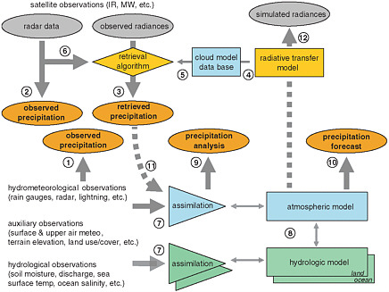 FIGURE 4.1 Conceptual visualization of GPM-era data integration and validation. The numbers provide links to the text. Dashed lines are used to indicate processes that will become more common in the near future, while double-ended arrows indicate two-way coupling. Drawing by M. Steiner, Princeton University. |
who use the data in their research-and-development activities, can be productively involved in identifying potential ground validation sites and data sets that would be of value for algorithm development and validation.
Finding: NOAA can provide a wide range of assets to assist GPM in mounting a comprehensive ground validation program over North
|
The ground-based precipitation measurements (rain gauge, radar, lightning data, etc.) will be merged to generate “observed precipitation” products (encircled 1) that may be useful in their own right and provide a basis for comparison to precipitation estimates from spaceborne sensors (encircled 2 and 3). Active microwave sensors (i.e., radar) aboard the Tropical Rainfall Measuring Mission (TRMM) and the GPM core satellite yield more direct observations of precipitation (encircled 2) (e.g., Marzoug and Amayenc, 1991; Iguchi et al., 2000) than infrared and passive-microwave radiances that involve more complicated algorithms to obtain “retrieved precipitation” estimates (encircled 3), potentially requiring a radiative transfer model (encircled 4) and cloud model data base (encircled 5) and/or radar information (encircled 6), as outlined in Box 3.2. The ground-based precipitation measurements, complemented by a range of hydrological observations and auxiliary data, will be assimilated into NWP models (encircled 7) that are coupled to hydrologic (land-surface and ocean) models (encircled 8). This process yields “precipitation analyses” (encircled 9) and “precipitation forecasts” (encircled 10) (including measures of uncertainty) that are internally consistent with the observations and model physics. In the near future, cloud- and precipitation-affected satellite-observed radiances will be directly assimilated as well (encircled 11) (e.g., Weng and Liu, 2003; Andersson et al., 2005; Greenwald et al., 2005). Alternatively, based on the information provided by the coupled land surface-atmosphere models, top-of-the-atmosphere radiances can be computed by means of a forward radiative transfer model (encircled 12). These processing streams provide many opportunities for diagnostic evaluation and feedback that will lead to improvements of retrieval algorithms, model physics, and data assimilation procedures alike. This evaluation may occur at the level of surface precipitation estimates (i.e., observed or analyzed versus retrieved) as well as top-of-the-atmosphere radiances (i.e., observed versus simulated brightness temperatures). While the former approach to “validation” has been the backbone during the TRMM era, the latter form of evaluation will be a key addition for GPM; will involve a detailed understanding of the microphysical processes; and will require appropriate four-dimensional dynamic, thermodynamic, and microphysical observations. Most of the evaluation and feedback activities are being worked on by a variety of groups within NOAA, NASA, JCSDA, universities, and internationally. The challenge is to make these activities work in a coherent way toward the common goal of improved precipitation forecasts. |
America. In addition to observational assets, NOAA can bring expertise in validation site selection, algorithm development, and modeling. Active participation in the GPM ground validation program will help the agency prepare for the GPM era. Operational centers can use data sooner if error characteristics are readily available
|
BOX 4.2 Hydrometeorological Testbed There will be a symbiotic relationship between GPM and the Hydrometeorological Testbed. The Hydrometeorological Testbed will use GPM data as an additional input for experimentation and demonstration, and GPM will obtain validation elements from the Hydrometeorological Testbed. The Hydrometeorological Testbed concept aims to accelerate the infusion of new technologies, models, and scientific results from the research community into daily National Weather Service forecasting operations. The Hydrometeorological Testbed is conceived as a process in which ideas for improved products and services are demonstrated in a quasi-operational setting (Figure 4.2). If the experimental products or tools stand up to rigorous tests of usefulness, accuracy, reliability, computational efficiency, cost-effectiveness, and repeated close scrutiny by users, they can make the transition to operations. Otherwise, user feedback leads to modifications of the products and another round of evaluation or to elimination of the candidate tool or method. 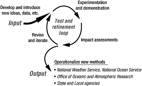 FIGURE 4.2 Conceptual design of the Hydrometeorological Testbed. Abbreviations are defined at the end of this report. SOURCE: Dabberdt et al., 2005. Reprinted with permission; copyright 2005. |
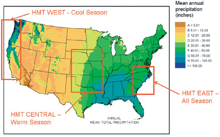 FIGURE 4.3 Regional focal areas for the Hydrometeorological Testbed. SOURCE: NOAA, 2006. Unlike typical research field projects, the Hydrometeorological Testbed operates as a demonstration with forecasters and researchers joining forces in the operational setting. The first full-scale deployment of this highly instrumented facility, which targeted California’s flood-vulnerable American River Basin, was completed in 2006. Two additional winter seasons are planned at this location. Following the California demonstration, Hydrometeorological Testbed facilities will be sequentially deployed to other regions of the United States (Figure 4.3) to address hydrometeorology problems that are unique to those locations. For example, the priorities of Hydrometeorological Testbed-West are on orographic effects, flooding, and water resources, while Hydrometeorological Testbed-East will focus on winter storms along the East Coast, with freezing rain, coastal cyclones (e.g., nor’easters), heavy snow, and lake-effect snow (Ralph et al., 2005). The project will run for a few years in each regional demonstration setting to determine its most useful new tools for improving precipitation and runoff forecasting methods. These successful tools will remain in place and will be duplicated (to the extent feasible) as the Hydrometeorological Testbed moves to the next region. |
from the calibration-validation teams for radiances and retrieved variables.
Recommendation 4.2: NOAA should explore ways of contributing observational assets and experience in site selection, modeling, and algorithm development to the GPM ground validation efforts. In addition, in partnership with NASA and other entities, NOAA should explore a comprehensive approach to international ground validation activities.
5.
Data Products
Once the calibrated and validated data from the GPM system become available, algorithm developers can use them to create derived products. This will eventually evolve into a real-time interface with data users. Whereas precipitation-related products can be patterned after those from ongoing efforts using remotely sensed data (see Chapter 3), a focus is needed on integrating GPM data with data from other satellite-based systems to provide a multisensor precipitation analysis (e.g., Box 3.2). From this analysis, hydrologic data assimilation products can also be derived. This will be facilitated by algorithm working groups within NOAA that are established well in advance of launch of the GPM core satellite. These groups, working closely with NASA counterparts, can engage in such efforts with available data sets (e.g., TRMM and Special Sensor Microwave/Imager [SSMI] data) as proxies until GPM core satellite data start flowing.
6.
Archiving and Distributing Precipitation Data
Archives of historical meteorological data are an important component of precipitation research and applications. Archived data are needed for a variety of purposes, including tracking weather and climate trends, calibration of operational instruments, and long-term assessment of climate.
NOAA’s National Climatic Data Center maintains climate records for NOAA historical data. As a World Data Center for Meteorology, the National Climatic Data Center also maintains many data sets from agencies around the world. This effort requires a number of steps, including acquisition, quality control, processing, summarization, dissemination, and preservation (NCDC, 2006), but securing resources to fund such an effort continues to be a challenge (NRC, 2006). The National Climatic Data Center may archive TRMM data as NOAA prepares for the GPM era; the National Climatic Data Center is engaged in discussions with NASA on this matter. Because TRMM is a NASA research mission, the raw data and processed products are currently archived in the NASA Distributed Active Archive Center at the Goddard Space Flight Center (NASA, 2006b).
Finding: TRMM data comprise a critical data set in the pre-launch phase of the GPM mission, and these data may be archived at NOAA’s National Climatic Data Center. Archiving additional data sets such as those from TRMM and GPM will pose challenges for the National Climatic Data Center.
Recommendation 4.3: As part of NOAA’s strategic plan for GPM, NOAA should develop strategies for meeting its archiving needs in preparation for and during the GPM era.
7.
Infusion of New Technology
The timely infusion of new technology into the operational environment is a necessary focus if NOAA is to remain competitive in delivering the best observations, forecasts, and reanalysis products to users in the GPM era. This includes infusion of technological advances in hardware (e.g., observing capability, data processing and distribution) and software (e.g., algorithms for retrieval, blending or assimilation of data, model physics).
Multipartner testbeds such as the Hydrometeorological Testbed (Box. 4.2) or JCSDA (Box 4.3) provide one potential vehicle for exploring and exploiting new technology. In such testbeds, real-time models and data assimilation systems that maximize the use of new observations (e.g., from the GPM constellation) could be developed and tested. Other potential benefits of testbeds include facilitating interactions among the observation, modeling, and data assimilation communities, both within NOAA and more broadly with other agencies and academia. In addition, testbeds offer a potential means of smoothing out cultural differences between the research and operational communities and facilitating a better understanding of participants’ needs, requirements, and limitations.
8.
Data Assimilation
The advanced instruments of current and planned satellite missions among NOAA, NASA, DOD, and international agencies can and will provide large volumes of data on atmospheric, oceanic, and land-surface conditions with unprecedented accuracy and spatial resolution. As discussed in Chapter 3, NWP forecasts are often sensitive to initial conditions in dynamically active areas with clouds and precipitation. Because these areas often have few conventional observations, satellite data assimilation is essential. Thus, significant advances in NWP forecast skill are expected through development of data assimilation systems that are better suited to handling precipitation, cloud, and soil moisture information. Typically, it takes 1-3 years to implement a new observation type into the operational data assimilation systems at NCEP and other NWP centers. For complex
|
BOX 4.3 Joint Center for Satellite Data Assimilation The JCSDA (Figure 4.4) was founded in 2002 to foster and accelerate research and development of assimilation techniques to accommodate the rapidly growing space-based data streams and to serve as a vehicle for technology transfer to operations. As a joint, distributed center it engages units of NASA (Goddard Space Flight Center [GSFC], Global Modeling and Assimilation Office [GMAO]); NOAA (National Environmental Satellite, Data, and Information Service [NESDIS] Office of Research and Applications; Center for Satellite Applications and Research [STAR]; National Weather Service [NWS]; NCEP; Environmental Modeling Cen 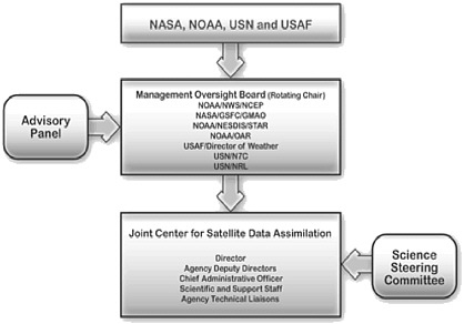 FIGURE 4.4 Schematic of the JCSDA. SOURCE: JCSDA, 2006. See Appendix E for definitions of acronyms. |
types of observations such as precipitation, the time frame is longer. JCSDA (Box 4.3 and Figure 4.4) is at the forefront of U.S. advances in data assimilation and will be a vital resource for NOAA as it prepares to assimilate data in the GPM era.7
A range of effort will be necessary with respect to assimilation. Initially, analyses will be needed to evaluate the requirements of the next-generation,
|
7 |
See the JCSDA web site at http://www.jcsda.noaa.gov. |
|
ter; Office of Oceanic and Atmospheric Research [OAR]); the U.S. Navy (USN) (Oceanographer of the Navy [N7C] and Office of Naval Research, Naval Research Laboratory [NRL]); and the U.S. Air Force (USAF) (Air Force Director of Weather, Air Force Weather Agency). The National Science Foundation is affiliated with JCSDA through the University Corporation for Atmospheric Research and supports a visiting scientist program on Global Positioning System/Radio Occultation (GPS/RO). JCSDA activities are divided into infrastructure development and proposal-driven scientific projects. Infrastructure development focuses on development and maintenance of a scientific backbone for JCSDA, whereas proposal-driven scientific projects are the primary mechanism for accelerating the transition of research and technological advances in remote sensing and data assimilation into the operational and product-driven weather and climate prediction environment. These activities have yielded assimilation techniques for NASA’s Atmospheric Infrared Sounder (AIRS), SSMI radiances, and GPS/RO measurements. In addition, a physically based retrieval method for sea surface temperature and a Special Sensor Microwave Imager/Sounder (SSMIS) radiance pre-processor have been developed. Along with providing monetary support for research projects, JCSDA has sponsored several workshops pertaining to satellite data assimilation, including ones focusing on GPS/RO, SSMIS, and cloud and precipitation assimilation. The assimilation of precipitation and cloud information is one of six priority research areas identified by JCSDA management for the proposal-driven scientific projects. Topics of particular interest within this research area include
In addition to handling data from satellite instruments, JCSDA is also tasked to prepare for assimilation of new data sources as they become operational. However, JCSDA’s ability to keep up with rapidly growing data streams is limited by its resources. |
four-dimensional variational (or ensemble) data assimilation systems, taking into account the required computational and scientific personnel resources. Careful consideration will be necessary for constraining the variational assimilation using derivatives of observations, such as cloud and rain type, particle size distributions, and height of the melting layer or cloud top, among others. Significant forecast skill advances may also come from other improvements, including making full use of all channels over land (presently hampered by inadequate knowledge of the surface emission), and include higher frequencies (e.g., 165 and 183 GHz) over oceans (particularly for higher latitudes, winters, and situations when
precipitation rates are low and precipitation is in the form of snow, cold drizzle, and sleet), refinements to the radiative transfer models used in assimilation (scattering by precipitation), and better characterization of background, model, and observational errors. Moreover, continued effort will be needed toward developing a global combined land-atmosphere-ocean assimilation system. Advances in assimilation will also be dependent on improvements in the treatment of moist physics in numerical models (see the following section).
It will be beneficial for data assimilation experts to become active members of sensor design and calibration-validation teams for future precipitation missions. From the perspective of benefits to assimilation efforts from such involvement, operational centers can use data sooner if error characteristics are readily available from the calibration-validation teams for radiances and retrieved variables. These errors include measurement errors, calibration errors or anomalies, and radiative transfer model errors. These errors are most useful for data assimilation if the error estimate includes information about the error probability distribution (i.e., the mean, standard deviation, and any relevant higher-order moments of the distribution).
Further mutual benefits will arise from coordinated efforts, knowledge, and sharing resources among data assimilation experts, satellite precipitation algorithm developers, and scientists involved in large interrelated projects (e.g., GEWEX [Global Energy and Water Cycle Experiment] and World Climate Research Programme) because of the availability of in situ observational data for validating the products and systems.
Finding: Given the lead time required to bring new precipitation data into operational assimilation schemes and given the potential gains in forecast skill from doing so, NOAA can begin preparing now for assimilating data in the GPM era to ensure that its operational forecast models, forecasters, and product users are ready for GPM data as soon as possible after launch of the GPM core satellite. The existing microwave imagers in orbit are either similar or identical to those that will be flown with GPM; only the GPM core satellite with its dual-frequency precipitation radar instrument is not available (although TRMM has a single-frequency precipitation radar). These instruments can be used to develop assimilation methods and to improve model physical parameterizations in preparation for the GPM mission.
Recommendation 4.4: NOAA should immediately enhance research and development on data assimilation, model or observation error characterization, and moist physics parameterizations in models using proxy data from TRMM to test their performance.
Finding: Assimilation schemes for using GPM data will benefit in particular from focused efforts on (1) making full use of all channels over land through better characterization of the surface emission, including higher frequencies (e.g., 165 and 183 GHz) over oceans; and (2) radiative transfer models, which can be tested using data sets that combine satellite data from the present GPM-like constellation and in situ data, as in the case of collaborative missions such as CloudSat.
Recommendation 4.5: NOAA should direct special effort to (1) making full use of all channels over land through better characterization of the surface emission, including higher frequencies (e.g., 165 and 183 GHz), and (2) constructing high-quality satellite and in situ data sets to fully assess radiative transfer model performance.
Finding: The collaborative activities at JCSDA are an example of a successful partnership between NOAA and NASA. JCSDA provides an interface between research and operations, thereby offering a potentially effective mechanism for accelerating the use of research data in operations. JCSDA is well positioned to invigorate and advance research on assimilating satellite data.
Recommendation 4.6: NOAA should strengthen and coordinate its support of JCSDA efforts on precipitation assimilation through the establishment of a NOAA steering group on space-based precipitation missions, as suggested in Recommendation 4.1 above.
Finding: U.S. and international data assimilation scientists and operational NWP centers benefit mutually in terms of shared interests, knowledge, and resources from joint engagement in sensor design and calibration-validation teams and through collaboration with algorithm developers and personnel from large, interrelated projects (e.g., GEWEX and the World Climate Research Programme).
Recommendation 4.7: NOAA should support participation of its data assimilation scientists on sensor design and calibration-validation teams. In addition, NOAA should encourage collaboration among U.S. and international assimilation scientists, precipitation algorithm developers, and personnel involved in large interrelated projects.
9.
Model Physics Development
Contemporaneous advances in model microphysics and assimilation of moisture information are crucial to maximize the value of high-quality precipitation data (Recommendation 4.3). Significant progress will be possible only if the model physics are capable of handling data inputs in an internally consistent way. Otherwise, models will tend to reject the assimilated information. In addition to advances in the physics, questions remain about the trade-off between increased spatial resolution and the complexity of the microphysics scheme (e.g., bulk versus explicit formulation, number of cloud and precipitation particle categories).
10.
Data Impact Evaluation
Comprehensive evaluation and diagnostic tools are cornerstones for advancing data assimilation and numerical model physics schemes as NOAA prepares for the GPM era. For example, simulated multispectral radiances can be evaluated against measured visible, infrared, and passive or active microwave satellite observations (Recommendations 4.3 and 4.4; Box 4.1).
Use of all data sources in such evaluations is valuable wherever and whenever possible. For example, data from TRMM’s single-frequency Precipitation Radar (and the dual-frequency Precipitation Radar during the GPM era), which provides unique information about the vertical structure of precipitation throughout the troposphere, are invaluable in diagnosing whether a model is capable of generating reasonable vertical moisture distributions within precipitating systems.
Observing System Simulation Experiments allow quantification of the relative contribution of single observation types to NWP model forecast skill. Using GPM as an example, these experiments require a data assimilation system that is capable of assimilating rainfall observations so that different configurations of observing systems with and without rainfall observations can be compared. If several existing satellites provide similar observations (e.g., SSMI, SSMIS, the TRMM Microwave Imager, and the Advanced Microwave Scanning Radiometer for the Earth Observing System [AMSR-E]), the impact can also be evaluated as a function of spatial or temporal data coverage.
Observing System Simulation Experiments will facilitate assessments of the sensitivity of a model’s forecast skill to GPM observations. In addition, Observing System Simulation Experiments can demonstrate the impact of adding spaceborne platforms and combinations of sensors in specific orbits and thereby provide important feedback for overall observing system design (Bauer et al., 2006b). In another approach, evaluating the propagation of observational uncertainties and errors through atmospheric and hydrologic models is key to providing accurate information for the end user and also to assess the potential for
future improvements in model physics, retrieval, or observational capabilities. The Pilot Evaluation of High-Resolution Precipitation Products is an example of a “grassroots” effort in data impact evaluation. Presently, this effort relies on volunteers.
11.
User Education and Training
User education, training, and feedback will be an important component in the success of the GPM mission. In the years leading up to the GPM launch, user conferences hosted by NOAA and NASA could help familiarize and educate potential users with the types of data and products that will become available. These conferences could continue through the post-launch and NOAA control phases, providing a vehicle for useful feedback from the community. NOAA has already set a precedent for such user conferences: the GOES-R program office has been holding such conferences for several years. These conferences aim to educate potential users about GOES-R and also to gain early feedback from the community on potential products, coverage, frequency, and resolution. In this regard, the user conferences are held with the goal of infusing user requirements into the design, operation, and implementation of GOES-R services.
SUMMARY
NOAA’s partnership with NASA for the GPM mission is essential to ensure that NOAA’s operational forecast models, forecasters, and product users are ready for GPM data as soon as possible after launch of the GPM core satellite. Joint NOAA-NASA activities are already under way, and increased NOAA support for these activities is needed to effectively engage in GPM planning. In addition, NOAA can start preparing for GPM now within the agency to make best use of the time available before launch of the GPM core satellite. NOAA’s preparation activities are framed in Chapter 5 within the context of a three-phase strategic plan for GPM.


