
Famine Early Warning and Remote Sensing—A User Perspective
Richard Choularton
Contingency and Response Planning Advisor, FEWS NET
The principal objective of the Famine Early Warning Systems Network (FEWS NET) is to provide actionable information to decision makers to prevent and respond to famines and food crises. Remote sensing has been one of the most important and successful tools used by FEWS NET to achieve this objective over the last 20 years.
Remote sensing provides a suite of invaluable tools for monitoring critical environmental processes that affect food insecurity. However, remote sensing products alone cannot tell the full story because food crises occur at the confluence of a complex web of interlocking environmental, political, economic, and social vulnerabilities.
Thus, a livelihood-based food security framework is used to interpret the potential impact of natural hazards on food and livelihood security. This type of analysis relies on baseline studies of how different populations are able to exploit the resources available to them. FEWS NET focuses on how populations in different areas access food and income and how they spend their income.
The combination of livelihood-based analysis, remote sensing, and other monitoring tools enables FEWS NET to interpret the likely impact of hazards such as drought or floods. This paper tries to illustrate how FEWS NET uses remote sensing to develop analyses to support decisions to combat food crises.
Recent literature stresses that famines and disasters are parts of broader processes. One such model is Turner’s stages of disaster model (Turner and Pidgeon, 1997). This model examines the aetiology of disasters and thus is useful for examining the role of remote sensing in famine early warning. Turner’s model defines six stages of disaster, as shown in Table F-1.
At each stage in this process, remote sensing tools are used to support food security analysis and decision support. This paper briefly illustrates how remote sensing is used with livelihood-based analysis to achieve FEWS NET’s objectives at different stages of disasters.
TABLE F-1 Stages of Disaster
INCUBATION PERIOD
Food crises occur when a complex web of factors conjoin, normally resulting in food shortages, malnutrition, sale of productive household assets (such as land or plough animals), distress migration, increased morbidity, excess mortality, and numerous other negative consequences.
The causal factors behind a food crisis develop and deteriorate over time. In the most food-insecure countries, the majority of the population is rural and dependent on rain-fed agriculture. These populations are highly vulnerable to changes in rainfall. Remote sensing of climatic conditions and derived agroclimatalogical analyses allow FEWS NET to monitor both short- and long-term changes that can impact food security. Livelihood analysis is then used to interpret the potential impact of these trends.
The current crisis in pastoral areas of the Horn of Africa, where more than 5 million people are currently facing pre-famine conditions, illustrates the use of remote sensing to inform food security early warning. This crisis whose epicenter is in northeast Kenya, southern Somalia, and southern Ethiopia has been triggered by the failure of the deyr, or October to December rainy season. Rainfall estimates (RFE) and crop water models such as the Water Requirement Satisfaction Index (WRSI) have enabled FEWS NET to identify and monitor the development of this drought (see Figure F-1).
While the current drought is the immediate trigger of the crisis, the crisis is rooted in a number of other factors, including a series of poor rainfall years over the last decade. A comparison of rainfall over the last decade helped to develop a longer-term understanding of the problem. Total annual rainfall, using satellite-derived rainfall data, was compared to a nominal minimum amount of precipitation required for viable pastures
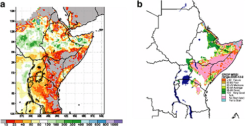
FIGURE F-1 Drought in the Horn of Africa. (a) Percentage normal precipitation (October–December 2005); (b) Rangeland condition—Extended WRSI December 2005. SOURCE: (a) FEWS NET/NOAA; (b) FEWS NET/USGS.
in the region (300 mm per year). Figure F-2 shows the results of this analysis.
TRIGGERING EVENT
Whether a hazard develops slowly like a drought or quickly like a flood, remote sensing helps analysts to define when a triggering event has occurred and to define its scope. In most countries where FEWS NET operates, information is sparse and not easy to access. Remote sensing allows FEWS NET to define where a hazard has occurred, its extent, and its severity. Using this information and livelihood baselines, FEWS NET is quickly able to provide decision makers with an analysis of the hazard’s impact on food security.
For example, a dry spell in February 2005 hit southern and central Mozambique during a critical time in its agricultural season. The dry spell was identified as a triggering event and its impact analyzed using FEWS NET’s livelihood baseline. In this example, even though Mozambique was facing its worst drought in five years, FEWS NET analysis determined that household food deficits would not necessarily emerge in all areas, because reliance on maize production varied in the affected areas. Cassava is widely cultivated in the Coastal Inhambane and Gaza Zones (31 in Figure F-3), Inharrime River Banks Zone (32), and Intermediate of Inhambane Zone
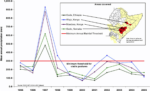
FIGURE F-2 Total annual rainfall (mm) for selected pastoral areas in the Great Horn of Africa in relation to the minimum threshold for viable pastures: 1995-2005. SOURCE: FEWS NET/NOAA ARC Dataset.
(33) and this crop was developing well. In addition, access to markets is relatively good in these areas. Households in these zones can also expand income from cashew sales and remittances in drought years.
In contrast to these areas, the analysis showed that drought would likely have a more significant impact on household food security for those living in the Semi-Arid Interior Zone (34) of Gaza and Inhambane provinces. Households in this zone are highly dependent on maize production and cropping is limited to only one season. When rains fail, market purchases, labor exchange, and consumption of wild foods complement poor households’ crop production. However, market access tends to be inadequate because the area is quite remote and households have limited resources with which to purchase food. To make matters more difficult, during a drought, households are forced to divert their time and income to secure sufficient water, limiting even further what they can spend on food.
In this example, remote sensing allowed FEWS NET to identify a triggering event and livelihood analysis enabled FEWS NET to quickly interpret the information to determine the food security impact several months before it was felt and almost nine months before impacts became most acute.
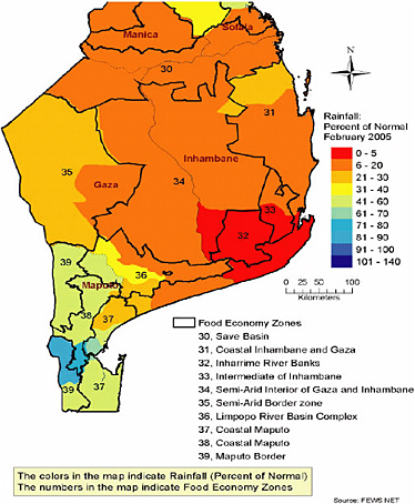
FIGURE F-3 Livelihood zones in the areas of southern Mozambique facing rain deficits. SOURCE: FEWS NET.
ONSET
When a crisis manifests itself, response agencies first need to assess the situation to determine how they will respond. However, in many countries, targeting scarce resources to undertake assessments is a challenge. Remote sensing allows FEWS NET and partners to target areas impacted by hazards, such as drought or floods, and thus maximize the use of assessment resources.
RESPONSE
Increasingly, the value of information collected and analysis conducted for early warning is being recognized as a tool to guide emergency response activities. While this is dominantly in the areas of food security and livelihood analysis, it also includes remote sensing data.
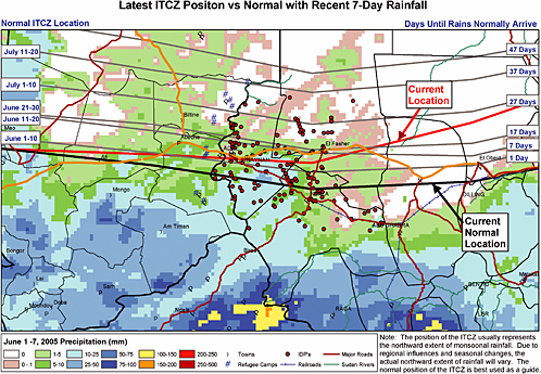
This was done for the FEWS NET Darfur Rain Timeline and Seven Day Forecast, which combines remotely sensed climate data with operational data (refugee camp locations, warehouse locations, roads, airports, etc). At the onset of the Darfur crisis, one of the most remote areas in Africa, there was a race against the rains to pre-position sufficient humanitarian supplies before the rains washed out roads preventing the delivery of aid to hundreds of thousands of displaced Darfurians. The Darfur Rain Timeline (Figure F-4) combines operational data on the location of displaced populations, transport infrastructure, and the normal position of the intertropical convergence zone (ITCZ), which in the Sahel region of Africa represents the leading edge of seasonal rains as they move northward at the onset of the rainy season and then retreat southward at the end.
RECOVERY
Remote sensing also helps food security analysts monitor conditions that support recovery following a famine or crisis. For example, the Niger crisis in 2005 peaked just as the country was experiencing one of the best rainy seasons in recent history. Remote sensing products such as the ITCZ analysis and WRSI provided early and regular updates on the progress of the rainy season. Another recent example can be found in northern Somalia, which experienced famine conditions after four years of drought between 2000 and 2004. In this case, RFE and vegetation analyses over the course of late-2004 and 2005 showed positive conditions for livestock, the mainstay of livelihood in the area. In both Niger and Somalia, groundbased data are scarce and difficult to access; thus, remotely sensed climate data and derived agroclimatalogical products fill in important gaps for analysts looking at the recovery from crisis, not only the descent into crisis.
CONCLUSION
Remote sensing is an invaluable tool for famine early warning and for supporting decision making to respond to crises. In addition, remote sensing can support the recovery process of famine-affected populations. When remote sensing data are put in context by using livelihood-based food security analysis, the result is a more insightful and valuable analysis, leading to more effective and earlier actions to mitigate food insecurity.
REFERENCE
Turner, B.A., and N.F. Pidgeon. 1997. Man-Made Disaster. Oxford, UK: Butterworth Heinemann.
Land Remote Sensing Applications for Human Welfare Support
Chris J. Johannsen
Professor Emeritus of Agronomy, Purdue University
INTRODUCTION
The Landsat Program was our first civil, non-weather satellite program, from which we could identify and map land resources. It was seen from its beginning as contributing to human welfare. For the first time on a regional basis, we were able to identify vegetation and soil patterns, inland water bodies, urban areas, road networks, and other features that were important to users and planners of many disciplines. While the Landsat Program put this nation in the forefront of remote sensing opportunities, it did not remain that way through the decades. From the beginning, the program was billed as a “research” satellite, and attempts at fostering operations were based on the revenues to be returned by commercializing the effort. The original model envisioned for remote sensing satellites was similar to that of the communications satellites, which were successfully transferred to commercial operations (NRC, 1995).
The Landsat System did whet the appetite for the use of satellite data for many purposes, especially in the research community. Plans for operational use of Landsat were weakened by the inability to sustain operations with only one operating satellite, changes in management, and other issues. The weather satellites had a distinct advantage when their series of satellites could show weather patterns on a global basis and more recently demonstrate the tracking of hurricanes, especially the prediction of landfall with specific times and location such as with Hurricane Katrina. The past hurricane season solidified congressional approval of the funding of the National Polar-orbiting Operational Environmental Satellite (NPOESS) into the foreseeable future.
APPLICATIONS
The applications program for remote sensing has had a varied approach. Early in the efforts of the National Aeronautics and Space Administration (NASA) from the late-1960s through the mid-1970s was a University Applications Grant Program directed by Joseph Vitale. This program provided funds for university researchers to acquaint potential users with remotely sensed data and to train them through directed
educational programs. Additionally the grants encouraged the development of college remote sensing courses to expose undergraduates and graduate students to remotely sensed data. Later during the 1980s through the 1990s, Alex Tuyahov at NASA Headquarters provided funds to encourage application development projects. Agencies such as the U.S. Geological Survey (USGS), U.S. Department of Agriculture (USDA), the National Park Service, and others provided grants with application thrusts on a changing basis.
A series of large application programs were initiated in preparation for Landsat. The Corn Blight Watch Program was in response to the Southern Corn Leaf Blight (SCLB). SCLB was first noted in 1970 in a number of cornfields in the Southern and Midwestern United States. This was an opportunity for NASA, USDA, Environmental Research Institute of Michigan (ERIM), and the Laboratory for Applications of Remote Sensing (LARS) to evaluate remote sensing using an Air Force RB57 aircraft with cameras, collecting data on selected flight lines over a seven-state area in the Midwest (Ohio, Indiana, Illinois, Iowa, Missouri, Wisconsin, Minnesota, and Nebraska). ERIM flew a 12-channel scanner over selected flight lines in the western half of Indiana, thereby providing a contrast to the photographic approach. From a practical standpoint, the program failed to detect SCLB until the corn crop was severely damaged. However, it did demonstrate the importance of temporal coverage for crop identification and the performance of timely analyses of vegetative growth, and it established the feasibility of digital, maximum-likelihood classification of aircraft multi-spectral scanner data for crop identification and condition assessment (Bauer, 1985).
With the launch of Landsat, a project called the Large Area Crop Inventory Experiment (LACIE) was initiated by NASA, USDA, and several universities. The purpose was to identify wheat throughout the Midwestern United States, and then expand to other countries such as Russia during its third year. LACIE developed a systematic approach to the analysis of Landsat data without ground truth information using temporal data collection and ancillary data such as weather data and USDA reports. The Agriculture and Resources Inventory Surveys Through Aerospace Remote Sensing (AgRISTARS) program expanded on the LACIE partnerships and looked at wheat, corn, and rice on a global basis. AgRISTARS was successful in demonstrating the value of timely data and limited ground reference information for identifying crops and predicting yield. The USDA Foreign Agriculture Service still uses the approaches that were developed during AgRISTARS.
Many National Research Council (NRC) studies have resulted in publications encouraging the development and funding of remote sensing application that benefit human welfare. The publication Earth
Observations from Space: History, Promise, and Reality (NRC, 1995) provided a bibliography of more than 300 publications on remote sensing topics as well as a good roadmap of the U.S. remote sensing program. NRC studies since that time have included remote sensing topics such as prospects for developing countries (NRC, 1997), supporting research and data analysis (NRC, 1998), ensuring a climate record (NRC, 2000a), the role of small satellites (NRC, 2000b), and assessment of mission size trade-offs (NRC, 2000c), National Spatial Data Infrastructure partnership programs (NRC, 2001), transformation of remote sensing data into information and applications (NRC, 2002a), new partnerships in remote sensing (NRC, 2002b), and use of remote sensing by state and local governments, (NRC, 2003b) to name a few. Additionally, a publication of strong interest to human welfare was People and Pixels (NRC, 1998), which for the first time directed attention to social concerns related to collection and analysis of remotely sensed data.
HIGH-RESOLUTION DATA
Most of our spatial data needs or wants are in the <5 m range for land resources mapping especially when we concentrate on human welfare. Note that there is a significant difference between “needs” and “wants,” and we are usually told what “we can get.” With the launch of commercial satellites providing high-resolution data such as Space Imaging and DigitalGlobe, we were provided with many of our “wants” as we started to see the benefits of 1 m data in obtaining information about urban land use categories, wetland communities, crop condition variations, forest inventories, and many other areas. The availability of this type of data in the future will depend on resolving many issues: concerns of high data costs especially when observing large areas, the financial viability of commercial companies, providing data for civilian uses during times of global conflicts, and other factors.
APPLICATIONS FUNDING
Through the history of the U.S. remote sensing program we have seen changes within NASA and other funding agencies relating to applications. If one follows the trend from the late 1960s to the present, you will see a “sine curve” effect, where the emphasis on applications is positive for about 8-10 years followed by an emphasis on research with a disregard for applications. The University Applications Grant Program of the 1960s was followed by a strong scientific pursuit during the mid 1970s, with a revival of the applications thrust in the mid 1980s. This seems to follow the change and emphasis of administrations as well as the national mood at
the time. We are currently in a research emphasis with applications funding directed to other federal agencies, who are also emphasizing research leaving little direction on applications. This has a discouraging effect on users and potential users of remotely sensed data.
THE FUTURE
My emphasis in the use of remote sensing has been directed toward agriculture. Fortunately, farmers took a strong interest in precision agriculture or site-specific management, where they were farming a field according to the needs of soils, drainage, fertility, crops, and similar factors for each specific location within the field. The use of global positioning systems (GPS) on farm equipment (especially on combines), so that a yield map could be made during harvest, caused farmers to ask for remotely sensed images during the growing season to assess problem areas within a field and to predict their yields prior to harvest. Geographic information systems (GIS) were employed to overlay images, maps, and data to make assessments at the end of a crop yield and to plan for the next year. This means that farmers are in a better position to plan for safe food supplies because they are using some of the technologies that are now being suggested for food security. Sensors are being developed and used to monitor vegetables as they move on a conveyor belt to identify damaged or unusual appearing fruits or vegetables as they are harvested or processed.
The SCLB of the early 1970s provided the stimulus for observing the Soybean Rust that is currently of concern to Midwestern and Southern U.S. farmers. Remote sensing was used to monitor soybean fields for premature crop changes possibly caused by the Rust. Fortunately, we did not have ideal growing conditions for the Rust during 2005, but further plans for monitoring the soybean crop are being developed for the 2006 growing season. Many U.S. soybean researchers have been studying Soybean Rust in Brazil during this winter to further their knowledge about this disease.
Foreign satellite data may lessen our concerns about the lack of a Landsat Program, even though a recent memo was released by the Office of Science and Technology Policy (OSTP) stating that a Landsat capability is not feasible on NPOESS and that NASA will pursue a plan for a freeflyer satellite to obtain future Landsat data. In the meantime, no attention or recognition has been given to RapidEye Corp., a German satellite company planning to launch a series of five satellites with bands similar to Landsat during 2007. This will be an operational satellite that could be employed for land use research and applications. Additionally, the Belgian government has teamed with South Africa to plan the launching
of a hyperspectral sensor after 2007, which could provide significant data for land use analysis and future applications.
In summary, a number of National Research Council boards have conducted remote sensing or related studies over the past 35 years that are valuable in their historical context. The current study related to food security and human health needs is very timely, because decisions will and are being made by our government on the future of this nation’s remote sensing capabilities. The agricultural aspects of these topics are important in reaching valid and beneficial recommendations.
REFERENCES
Bauer, M.E. 1985. Spectral inputs to crop identification and condition assessment. Proc. IEEE V 73(6):1071-1085.
NRC (National Research Council). 1995. Earth Observations from Space: History, Promise and Reality. Washington, DC: National Academy Press.
NRC. 1997. Remote Sensing from Space: Prospects or Developing Countries. Washington, DC: National Academy Press.
NRC. 1998. People and Pixels: Linking Remote Sensing and Social Science. Washington, DC:, National Academy Press.
NRC. 2000a Ensuring a Climate Record from the NPP and NPOESS Meteorological Satellite. Washington, DC: National Academy Press.
NRC. 2000b. The Role of Small Satellites in NASA and NOAA Earth Observation Programs. Washington, DC: National Academy Press.
NRC. 2000c. Assessment of Mission Size Trade-offs for NASA’s Earth and Space Science Missions. Washington, DC: National Academy Press
NRC. 2001. National Spatial Data Infrastructure Partnership Programs. Washington, DC: National Academy Press.
NRC. 2002a. Transforming Remote Sensing Data into Information and Applications. Washington DC: The National Academies Press.
NRC. 2002b. Toward New Partnerships in Remote Sensing. Washington, DC: The National Academies Press.
NRC. 2003. Using Remote Sensing in State and Local Government: Information for Management and Decision Making. Washington, DC: The National Academies Press.
Land Remote Sensing for Decisions on Human Welfare: Opportunities and Challenges
David J. Rogers
TALA Research Group, Department of Zoology,
Oxford University, U.K.
Human actions are usually determined by our view of the world around us, our ability to connect one observation with another, and our interpretation of those connections in meaningful ways. Remotely sensed satellite data provide us with a relatively new and certainly unique opportunity to improve the situation of the whole of humankind through better habitat and environmental management. Satellite data are especially promising for understanding human, agricultural, and environmental interactions at a range of scales and for dealing with the many health, agricultural production, or environmental change (degradation) problems that threaten the sustainability of some of the planet’s most disadvantaged communities.
This paper highlights some of the progress to date, speculates on the future potential of this technology, and finally makes a plea for the continuation of relevant earth observation missions into the future.
ENVIRONMENTS
High-resolution Landsat and SPOT data have traditionally been used to examine environments from space. Their detailed views appeal to our own acute visual powers and our usual wish to see as much as possible of environmental detail. Multi-temporal NOAA and TERRA satellite data give us seasonal imagery of poorer spatial resolution, which is nevertheless much more useful for understanding seasonal events associated with agriculture and the transmission of many tropical diseases. Temporal Fourier analysis allows us to produce novel images from such multi-temporal data that capture habitat seasonality in unique ways; the processed data are statistically independent (i.e., orthogonal) and biologically meaningful. Such data may be clustered to reveal large- or small-scale patches of environmental similarity (“ecozones”) and thus provide a unique view of the scenery of the human as environmental tragedy.
AGRICULTURE
Subsistence agriculture is constrained by the environment in ways that may be revealed by comparing the clusters of agricultural indicators (the local abundance of humans, crops, and cattle; i.e., “farming systems”) with the ecozones derived from satellites. Often there is an exceptionally good pattern match (formally revealed by the ecological technique of correspondence analysis). The distributions of human farming systems are as much a victim of their environments as are the distributions of tigers or tsetse flies. This has implications for the developmental routes along which subsistence agriculture should, or should not, be supported by development programs.
HUMAN AND ANIMAL HEALTH
Infectious diseases in the tropics have spatially and seasonally varying impacts that can most usefully be studied using satellite data. We distinguish statistical, or “pattern-matching,” models from “process-based,” or mechanistic, models applied to such diseases. While we prefer the latter for their ability not only to foretell the future, but also to predict the outcome of “what if?” modelling exercises of alternative intervention strategies, we nevertheless must acknowledge that, for most diseases (even important ones such as malaria), currently we only have sufficient information to follow the pattern-matching route. Nevertheless a careful application of this approach can suggest fundamentally important links between environmental drivers (including climate) and demographic processes (birth, death, infection, recovery), and these perceived links can begin to inform a process-based modelling approach. Satellite data thus neatly bridge the two rather different approaches to infectious disease modelling. Examples from the wide field of vector-borne diseases are given. The pattern-matching technique is extremely flexible and achieves respectable levels of accuracy remarkably consistently. It is critical at this point to ask if this flexibility means that we are describing simply the data or the disease itself. It is suggested that an information-theoretic approach within a maximum likelihood discriminant analytical framework provides sufficient checks and balances to ensure a robust outcome.
We deal briefly with the issue of data quality. No health statistics are ever complete, and none appear unbiased. When we construct our models we must try to allow for sampling errors and biases, in order to extract as much information from the background noise as is possible. A variety of mathematical (bootstrap) and more ecologically-based (environmental envelope expansion) techniques may help us to get the maximum amount of information from the data. We borrow and adapt a maxim from
modelling in general, and epidemiology in particular, and warn that “all maps are wrong, but some are useful.”
BIODIVERSITY MONITORING
The same techniques applied to tropical diseases may be used to describe the distribution of individual species of conservation importance, and communities of species, thus providing a common currency for resolving conflicts between human agricultural expansion on the one hand and conservation concerns on the other.
ENVIRONMENTAL CHANGE
Time series of satellite data may be used to examine environmental trends over time. There are considerable difficulties in detecting change in both high- and low-resolution imagery, brought about partly by design changes in the satellite platforms (spectral characteristics, overpass frequency) and degradations of both the satellite orbit and instrument performance over time. If adjustments can be made for these, we have series of images stretching back about 30 (Landsat) or 20 (NOAA AVHRR) years.
POVERTY MAPPING
Poverty is a multi-dimensional constraint on development in many tropical countries. Many of the dimensions of poverty are environmental (food, fuel, water, health), and we have recently explored the environmental-poverty links at a variety of scales in Africa, using sets of socioeconomic data that are more traditionally analyzed using small-area mapping techniques developed by the World Bank. We find relationships between satellite-derived environmental variables and poverty indices that are at least as strong as those discovered using the more traditional techniques that tend only to exploit the correlations within (socioeconomic survey) data sets. The great advantage here is that environmental variables are more likely to point to the causes of poverty than merely its correlates.
SMALL-WORLD EFFECTS— EMERGING AND REEMERGING DISEASES
International trade and travel have effectively reduced the distance between areas of the world that have completely different suites of animals, plants, and diseases, thereby increasing the chances of international transport of pathogens. By examining environmental conditions across the
world’s air- and seaport network, we can begin to make sense of some dramatic international movements in the past (mostly of insect vectors of disease) and therefore predict and anticipate similar movements in the future.
OPPORTUNITIES
None of the satellites used for these studies was designed with health or welfare applications in mind. Famine early warning systems, now established for many years, may now be supplemented by global disease monitoring and early warning systems feeding into poverty monitoring and early warning systems. In turn, environmental protection could arise from a biodiversity monitoring and early warning system, all driven by timely and accurate remotely sensed data.
CHALLENGES
The challenges involve constructing an archive of global environmental data (through the Global Earth Observation System of Systems) accessible at zero cost to all; developing appropriate image-processing algorithms producing relevant, processed data layers; developing robust predictive models for biodiversity, agriculture, health, poverty, and environmental changes through time; linking model outputs to the formulation of environmentally sound policies that are effective at the grass-roots level; and producing a monitoring and feedback system that returns quality field data from project areas, to improve the modelling process.
REFERENCE
Advances in Parasitology, Volumes 47 (2000) and 62 (in press) contain a variety of papers on the applications of satellite imagery to vector and disease monitoring, mapping, and spread.
Famine Early Warning Systems Network: Use of Remote Sensing to Monitor Food Security in Africa1
James Verdin
U.S. Geological Survey
Center for Earth Resources Observation and Science Sioux Falls, South Dakota
INTRODUCTION
In sub-Saharan Africa, large and widely dispersed populations depend on rain-fed agriculture and pastoralism; hence, climate monitoring and forecasting are important inputs to food security assessment. Conventional hydrometeorological networks are sparse and often report with significant delays (Washington et al., 2004). Consequently, the requirements of famine early warning have inspired creative uses of remote sensing, numerical modeling, and geographic information systems. Satellite vegetation index imagery has been used since the mid-1980s to identify anomalies in seasonal landscape green-up that indicate drought (Hutchinson, 1991). Satellite rainfall estimates (RFE) (Xie and Arkin, 1997) fill in gaps in station observations and serve as input to drought and flood index maps and models that illustrate the implications of spatial and temporal precipitation patterns.
The Famine Early Warning System Network (FEWS NET) employs a livelihoods framework to geographically characterize vulnerability and interpret hazards (Boudreau, 1998). By assembling information on how households access food and income, routine monitoring of rainfall, vegetation, crops, and market prices is made more meaningful. Implications for key food security questions are more readily derived, such as: Which population groups are facing food insecurity, and for how long? What are the best ways to mitigate adverse trends or shocks to their livelihood systems?
The National Oceanic and Atmospheric Administration, U.S. Geological Survey, National Aeronautics and Space Administration, and others (including the U.S. Department of Agriculture, FEWS NET/Chemonics,
and the U.S. Agency for International Development) routinely review a suite of remote sensing and forecast products to produce a weekly Africa Weather Hazards Assessment. Hazards are superimposed on livelihood zones, and each source of food and income for the relevant profiles is evaluated to determine if a food or income gap will result. Population groups at high risk of acute food insecurity can be identified and quantified, as can prospects for the duration of the problem.
LAND REMOTE SENSING
Current season monitoring by FEWS NET makes extensive use of satellite image products to achieve early detection of drought. Vegetation index images have been used since the mid-1980s to monitor the crop and rangelands of semiarid sub-Saharan Africa (Hutchinson, 1991). The Normalized Difference Vegetation Index (NDVI) exploits the contrast between red and near-infrared reflectance of plant canopies. It is proportional to leaf area index, intercepted fraction of photosynthetically active radiation, and density of chlorophyll in plants (Tucker and Sellers, 1986). Maximum value composites for dekads (WMO, 1992), nominally 10-day periods, are used to overcome cloud cover problems. Images from several different sensors are used to make the NDVI composites used by FEWS NET. They include the NOAA AVHRR, SPOT Végétation, and NASA Moderate Resolution Imaging Spectrometer (MODIS). The time series of AVHRR NDVI images, calculated by the NASA Global Inventory Monitoring and Modeling Studies group (Tucker et al., 2005), has 8 km resolution and is continuous since July 1981. SPOT Végétation NDVI images have 1 km resolution and have been available since 1998, while the MODIS NDVI images used by FEWS NET have 500 m resolution with a continuous series available since 2000.
Typically, a seasonal trace of mean NDVI over a crop or rangeland zone of interest is made to illustrate green-up and senescence. Traces for a long-term mean and recent years are also shown for comparison purposes. Figure F-5 gives an example for an important maize-growing region of Zimbabwe.
REMOTE SENSING ESTIMATES OF PRECIPITATION
Current season monitoring also depends heavily on satellite rainfall estimates (RFE). In Africa, the primary product used by FEWS NET is the RFE 2.0 from the NOAA Climate Prediction Center. The algorithm for this product, described in Xie and Arkin (1997), involves a geostatistical blend of rainfall station data with imagery from thermal infrared and microwave sensors. Estimates of 24-hour precipitation totals are made for each grid
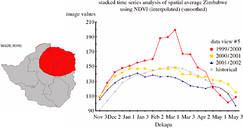
FIGURE F-5 NOAA AVHRR NDVI seasonal traces by dekad for a key maizegrowing region in Zimbabwe: 1999-2000 was a year of abundant rainfall and vigorous vegetation growth; 2001-2002 was a year of drought and poor crop performance; 2000-2001 was about average.
cell at 0.1 degree resolution (approximately 10 km) and are available the following day. There are only about 400 rainfall stations across the African continent that report each day via the World Meteorological Organization’s Global Telecommunication System. The RFEs consequently fill in what would otherwise be large spatial gaps in FEWS NET rainfall monitoring. The inclusion of those station data that are available significantly reduces the bias inherent in estimates based on satellite data alone. Furthermore, RFE 2.0 estimates show better agreement with surface observations than do numerical atmospheric model precipitation fields. In a test case in western Kenya, RFE 2.0 estimates agreed with observations over a dense gauge network significantly better than did numerical atmospheric model estimates, explaining 80 percent of the variance, compared to 20 percent for atmospheric model estimates (Funk and Verdin, 2003).
Satellite RFE have been especially useful as input to a geospatial crop water balance model that evaluates the availability of moisture to a crop relative to its needs over the course of the growing season. Frère and Popov (1986) originally developed the Water Requirement Satisfaction Index (WRSI) for calculation with rainfall station data. It has been adapted to use on a geospatial basis to facilitate wide-area monitoring (Verdin and Klaver, 2002; Senay and Verdin, 2003). The WRSI varies from
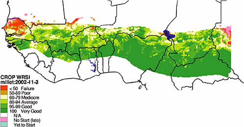
FIGURE F-6 Map of the Water Requirement Satisfaction Index for the Sahelian countries of West Africa, 2002. Intervals of WRSI correspond to levels of crop performance. Growing conditions for millet that year were especially poor for northern Senegal and southern Mauritania. Image created by Gabriel Senay, USGS. Used with permission.
0 to 100 and is the ratio of actual crop evapotranspiration to the amount that would occur with a full water supply. This quantity has been shown to be a good indicator of yield reduction due to water limitation (Doorenbos and Kassam, 1986). Maize yield estimates based on WRSI (calculated with RFE) were found to agree (R = 0.8) with official reports in a test with 1996-1997 data for Zimbabwe (Verdin and Klaver, 2002). Figure F-6 gives an example WRSI map for the West African Sahel.
REMOTE SENSING OF SURFACE WATER
Tracking trends in the elevation of the water surface of major lakes and reservoirs can provide valuable insight into the relative abundance of water for human consumption, agriculture, and pastoralism. NASA and USDA have successfully adapted systems for radar altimetry of the oceans to monitoring water bodies in Africa. Figure F-7 illustrates evidence of multi-year drought in East Africa developed with Topex Poseidon-Jason 1 data.
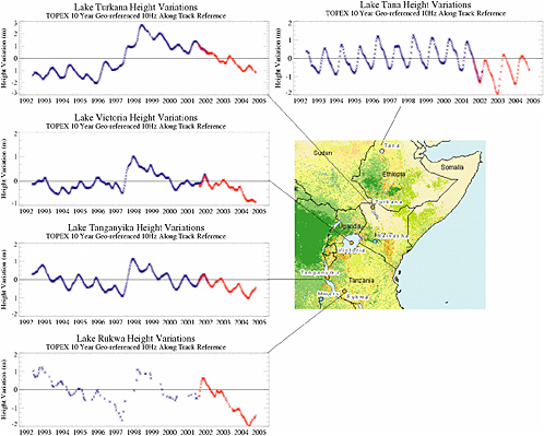
FIGURE F-7 Topex Poseidon-Jason 1 lake levels for five lakes in the Greater Horn. Time series and imagery obtained from the USDA PECAD crop explorer: available at http://www.pecad.fas.usda.gov/cropexplorer/global_reservoir/.
FUTURE OF REMOTE SENSING SYSTEMS
In terms of land remote sensing, FEWS NET is increasingly making use of the improved spatial resolution offered by MODIS. The AVHRR NDVI time series, dating back to 1981, will continue to play a vital role, however, due to its value in developing climatological norms. The Visible Infrared Imager Radiometer Suite on the upcoming National Polar-orbiting Operational Environmental Satellite System will maintain continuity into the future for wide-area, high-frequency vegetation index imagery.
The Global Precipitation Measurement (GPM) mission will ensure the future of remote sensing estimates of rainfall. GPM builds on the success of the Tropical Rainfall Measuring Mission (TRMM). The GPM international constellation of satellites will increase the availability of microwave estimates of precipitation, reducing and ultimately eliminating the need for reliance on thermal infrared image data.
The Water Elevation Recovery (WatER) mission has been proposed to explicitly map inland water body surface elevations. Building on the success of interferometric synthetic aperture radar on the Shuttle Radar Topography Mission and radar altimetry missions such as Topex Poseidon, WatER promises to map changes in water height and slopes of inland water surfaces with centimeter accuracy. If authorized, the mission would be of great benefit over the wide regions of Africa (and much of the Earth) that lack adequate conventional stream gauging.
SUMMARY
Monitoring rain-fed subsistence agriculture and rangeland conditions is a key input to food security assessment in sub-Saharan Africa. Satellite remote sensing has played a vital role since the 1980s by complementing sparse conventional surface climate monitoring networks. Estimates of vegetation vigor, rainfall distribution, and surface water supplies are forthcoming from current systems. Future remote sensing missions, planned and proposed, promise to provide increasingly higher-quality coverage in terms of spatial resolution, frequency of acquisition, and sensor technology. Full implementation of these missions will be vital to famine early warning in Africa, because surface climate monitoring networks, unfortunately, continue to weaken—a trend that is not likely to improve any time soon.
REFERENCES
Boudreau, T. 1998. The food economy approach: A framework for understanding rural livelihoods. Relief and Rehabilitation Network Paper, Overseas Development Institute, London.
Doorenbos, J., and A.H. Kassam. 1986. Yield response to water. FAO Irrigation and Drainage Paper No. 33. Rome: FAO.
Frere, M., and G. Popov. 1986. Early agrometeorological crop yield assessment. FAO Plant Production and Protection Paper 73. Rome: FAO.
Funk, C., and J. Verdin. 2003. Comparing satellite rainfall estimates and reanalysis precipitation fields with station data for western Kenya. Proceedings of the International Workshop on Crop Monitoring for Food Security in Africa, European Joint Research Centre/UN Food and Agriculture Organization, Nairobi, Kenya, 28-30 January.
Hutchinson, C.F. 1991. Use of satellite data for famine early warning in sub-Saharan Africa, International Journal of Remote Sensing 12:1405-1421.
Senay, G., and J. Verdin. 2003. Characterization of yield reduction in Ethiopia using a GIS-based crop water balance model. Canadian Journal of Remote Sensing 29(6):687-692.
Tucker, C.J., and P.J. Sellers. 1986. Satellite remote sensing of primary production, International Journal of Remote Sensing 7:1395-1416.
Tucker C.J., J.E. Pinzon, M.E. Brown, D. Slayback, E.W. Pak, R. Mahoney, E. Vermote, and N. El Saleous. 2005. An extended AVHRR 8-km NDVI data set compatible with MODIS and SPOT Vegetation NDVI data. International Journal of Remote Sensing 26(20):4485-4498.
Verdin, J., and R. Klaver. 2002. Grid cell based crop water accounting for the Famine Early Warning System. Hydrological Processes 16:1617-1630.
Verdin, J., C. Funk, G. Senay, and R. Choularton. 2005. Climate science and famine early warning. Philosophical Transactions of the Royal Society B 360(1463):2155-2168.
Washington, R., M. Harrison, and D. Conway. 2004. African Climate Report. University of Oxford. Available online at http://www.eldis.org/static/DOC16980.htm.
World Meteorological Organization. 1992. International Meteorological Vocabulary. WMO Publication 182, second edition, Geneva, Switzerland.
Xie, P., and P.A. Arkin. 1997. A 17-year monthly analysis based on gauge observations, satellite estimates, and numerical model outputs. Bulletin of the American Meteorological Society 78(11):2539-2558.
Forecasting the Spread and Risk of Infectious Disease
Terry L. Yates
Vice-President for Research and Economic Development University of New Mexico, Albuquerque, New Mexico.
Hantaviruses are a group of negative-stranded RNA viruses, some of which are known to be highly pathogenic for humans. Diseases caused by hantaviruses were thought to be largely restricted to Europe and Asia, until 1993 when an outbreak of hantavirus pulmonary syndrome (HPS) caused by a previously unknown hantavirus, Sin Nombre virus (SNV), occurred in the Southwestern United States. The new virus initially resulted in a fatal outcome in more than 50 percent of human cases, and the deer mouse, Peromyscus maniculatus, was found to be its primary reservoir (Nichol et al., 1993). Since the discovery of SNV, some 27 additional hantaviruses have been described from the New World (Schmaljohn and Hjelle, 1997; Peters et al., 1999). The cause of the outbreak in 1993 has remained speculative. More than ten years of ecological monitoring in the American Southwest and the results of retrospective serosurveys for SNV using archived rodent samples suggest a climate-driven trophic cascade model for SNV outbreaks in North America. It appears that increased late winter and spring precipitation in the Southwestern United States driven by the El Niño-Southern Oscillation was responsible for an increase in plant primary productivity, which in turn resulted in increased rodent population densities. A direct but delayed correlation exists between increases in deer mouse population densities, increases in density of infected rodents, and increased incidence of HPS. Furthermore, retrospective data show that SNV and other New World hantaviruses have been present, essentially in their current form, in the Western Hemisphere for at least decades and probably have been coevolving with their rodent hosts in the New World for approximately 20 million years (Yates et al., 2002).
An understanding of the relationship between climate change, ecology, and hantaviruses may enable development of improved predictive models for prevention of human infection and improve our understanding of biocomplexity on a rapidly changing planet. We propose a complex trophic cascade triggered by climate fluctuation as a model for predicting HPS risk to humans. In addition, data from our studies in North and South America suggest that certain human land use patterns that result in a reduction of biological diversity favor reservoir species for hantavirus and significantly increase human risk for HPS. These data make
it clear that understanding the ecology of infectious diseases will take a long-term, multidisciplinary effort—one that is essential to public health efforts of the future.
Although on a broad regional scale there is an increased risk to humans from the trophic cascade triggered by increased precipitation input into the environment, the actual risk to humans is highly localized and depends on a complex series of variables. Other factors, such as landscape heterogeneity, microclimatic differences, rodent disease, local food abundance, and competition, may be involved as well, and such complexity will have to be taken into account before a predictive model of HPS risk can be developed on a fine-grained scaled.
Understanding the biological complexity of natural and humandominated ecosystems will be required before ecological and evolutionary forecasting can be employed on the scale needed to safeguard the public health against hantaviral and other zoonotic disease outbreaks. Largescale, long-term, multidisciplinary studies also will be necessary to determine if foreign or genetically modified pathogens are being introduced into our ecosystems.
Near real-time forecasting of risks of these types of diseases will be possible only if remote and other types of sensing become utilized on a continental or global scale. One example, based on hantavirus in the American Southwest, is discussed as a possible model for a wider array of applications.
REFERENCES
Nichol, S.T., C.F. Spiropoulou, S. Morzunov, P.E. Rollin, T.G. Ksiazek, H. Feldmann, A. Sanchez, J. Childs, S. Zaki, and C.J. Peters. 1993. Genetic identification of a hantavirus associated with an outbreak of acute respiratory illness. Science 262:914-917.
Peters, C.J., G.L. Simpson, and H. Levy. 1999. Spectrum of hantavirus infection: haemorrhagic fever with renal syndrome and hantavirus pulmonary syndrome. Annual Review of Medicine 50:531-545.
Schmaljohn, C., and B. Hjelle. 1997. Hantaviruses: a global disease problem. Emerging Infectious Diseases 3(2):95-104.
Yates, T.L., J.N. Mills, C.A. Parmenter, T.G. Ksiazek, R.R. Parmenter, J.R. Vande Castle, C.H. Calisher, S.T. Nichol, K.D. Abbott, J.C. Young, M.L. Morrison, B.J. Beaty, J.L. Dunnum, R.J. Baker, J. Salazar-Bravo, and C.J. Peters. 2002. The ecology and evolutionary history of an emergent disease: hantavirus pulmonary syndrome. BioScience 52:989–998.


