
1
A Rationale for River Science
Rivers are the circulatory system of the continents (Gomi et al., 2002). They are the conduits for water, solute, and sediment movement from the land to the sea and shape much of the landscape. Rivers have distinct biological and ecological qualities, which are driven by their flows and capacity to store materials and nutrients.
Throughout history, our society has valued rivers and their riparian areas both economically and aesthetically. Indeed, rivers are part of our nation’s collective consciousness; they are entwined with American history, folklore, art, traditions, and literature. Our nation’s rivers have provided drinking water, fisheries, and game habitat that sustained communities built along riverbanks (Haites, 1975). Early on, they were vital transportation routes and sources of waterpower. River bottomlands have been transformed into productive agricultural lands, and water diversions irrigate vast farmlands using water that is far removed from its river source. Our rivers have also served as navigation channels, transporting goods as the nation expanded. Hydroelectric power, harnessed primarily in the 20th century by the damming and diversion of rivers, helped supply the nation’s growing electrical power needs. By the end of the 1970s, dams had been constructed on most of the nation’s largest rivers for hydropower, irrigation water, flood control, navigation, and other benefits.
We continue to depend on rivers today. Rivers provide about 60 percent of the nation’s drinking and irrigation water (http://water.usgs.gov/pubs/circ/2004/circ1268/, revised February 2005) and 10 percent of the nation’s electric power needs (http://www.ieahydro.org/Bur-Recl-web/questions/history.htm). Boating, birding, swimming, and fishing on rivers and their reservoirs are multibillion-dollar industries. Other indirect benefits that rivers and their riparian zones pro-
vide are becoming common wisdom (Malanson, 1993). For example, rivers buffer and attenuate flood peaks by storing water in their floodplains. Attendant sediment deposition replenishes floodplain soils, and within the floodplains, microbes help to efficiently process and recycle nutrients. Additionally, the sediment remaining in the river is transported downstream where it replenishes beaches and deltas.
Viewed from a scientific perspective, American society is conducting a great, uncontrolled experiment on the interconnected river systems of the nation, and human activities have profoundly changed the nature of our nation’s rivers. Today, few rivers are pristine or free flowing. Beginning with deforestation by European settlers for agricultural land use in the 1700s and continuing with urbanization, floodplain cultivation, dam and levee construction, and channelization, human activities have dramatically altered natural flow regimes. These changes have often exacerbated natural flooding, such as when spring snowmelt on the Red, Mississippi, and Missouri Rivers covered large swaths of the continental interior with attendant loss of life and property damage (Barry, 1997; Shelby, 2003). Enhanced sediment erosion and transport often accompany such floods, and in the process, rivers become incised and ecological diversity is lost. Modifications to natural flow regimes have led to declines in commercial river fishing in California, New England, the Southeast, the upper Midwest, and most recently the Northwest where human activities have disrupted the life cycle of salmon (NRC, 2004a).
The introduction of non-native species has decimated native fish populations in some cases (USGS, 1998). Water quality has suffered from deforestation, tillage, and urbanization. Industrial, domestic, and agricultural wastes frequently contaminate rivers. Trace metals, arsenic, organic contaminants, excessive loads of nitrogen and phosphorus, human pathogens, and thermal discharges from power plants are present in the nation’s surface waters. Overall, the degradation of rivers and their riparian ecosystems has impacted flood storage, aesthetics, fisheries, clean water, and other river-related goods and services that the nation has come to value and depend upon.
NATIONAL INTEREST IN RIVER SYSTEMS
River goods and services, and thus the conditions of rivers and riparian ecosystems, are important at local, regional, national, and international levels. Rivers cross state and international boundaries, and actions in one state have impacts elsewhere. Therefore, not surprisingly, there has been a long-standing national interest in river systems.
In the past, the national interest was focused on the human utilization of river resources. In 1851 the Supreme Court defined navigable waterways for federal responsibility as streams that served interstate or international commerce, and subsequent rulings were very liberal in defining navigation. As early as
1894, Congress appropriated funds to the USGS for “gauging the streams and determining the water supply of the United States” (U.S. Statutes at Large, v. 28, p. 398). Indeed, from early on the USGS was given the mission and thus the responsibility of managing these streams, which were defined by law as “waters of the United States” (U.S. Army Corps of Engineers Regulations, 33 CFR Part 328, Definition of Waters of the United States, http://www.usace.army.mil/inet/functions/cw/cecwo/ reg/33cfr328.htm).
In 1925, Congress directed the U.S. Army Corps of Engineers and the Federal Power Commission (a joint committee of the Departments of War, Interior, and Agriculture) to identify navigable rivers and their tributaries where hydroelectric power development would be practical. The information was to be used to formulate “general plans for the most effective improvement of such streams for the purposes of navigation and the prosecution of such navigation improvement in combination with development for power, flood control, and irrigation” (Buie, 1979). After the devastating Mississippi River floods of 1927, Congress called on the Corps of Engineers to protect the vast floodplain lands of the lower Mississippi by building levees, floodways to divert excess flows, and flood control reservoirs on its major tributaries. And in the midst of the Great Depression, the Tennessee Valley Authority was authorized in 1933 to build dams to control floods, improve navigation, provide hydroelectric power, and to develop programs for soil erosion control and reforestation for the rural Southeast.
More recently, the national interest in rivers has evolved to include protecting the quality of river systems and their use by aquatic and riparian species, as demonstrated by the passing of the Wild and Scenic Rivers Act, the National Environmental Policy Act, the Clean Water Act, and the Endangered Species Act. The Wild and Scenic Rivers Act (16 U.S.C. 1271-1287) was passed in 1968 to protect the free-flowing character of certain rivers that were selected for having exceptional wild, scenic, or recreational values. In 1969, the National Environmental Policy Act established a national framework for protecting our environment, including its freshwater systems (42 U.S.C. s/s 4321 et seq.). Today, the environmental impact assessments of proposed infrastructure projects are integral to the public debate surrounding new development. The nation passed the Federal Water Pollution Control Act Amendments of 1972, commonly known as the Clean Water Act (CWA) (33 U.S.C. 1251 et seq.) as a response to river contamination. Since the act was passed, the fraction of the nation’s rivers considered “swimmable and fishable” has increased from one-third to two-thirds, and the number of people served by secondary wastewater treatment has more than doubled (http://www.acnatsci.org/education/kye/pp/kye102002.html). In 1973, the Endangered Species Act, which called for the identification of our nation’s threatened and endangered species, was passed and has since provided mechanisms for acquisition and maintenance of “critical habitat” for these species (7 U.S.C. 136; 16 U.S.C. 460 et seq.).
Despite the many federal initiatives designed to protect rivers, gaps in our
scientific understanding of river processes often limit our ability to manage rivers effectively. With human population growth, the demand for river goods and services is increasing, while recurrent drought, floods, and climate change raise concerns about the sustainable use of river systems in the future (Postel et al., 1996; Vörösmarty et al., 2000; Poff et al., 2003). Furthermore, human impacts on the landscape have reached unprecedented levels, and now rival the forces of nature in their effects on rivers. Today, the multiple, sometimes incompatible services we demand of rivers and their riparian corridors and watersheds have led to conflicts among the many beneficiaries of river services (Baron et al., 2002; Naiman et al., 2002). Difficult policy and management decisions about river functions increasingly require the integration of science-based information that crosses traditional scientific disciplines. To better inform decision making, managers and policy makers seek input from science on how river systems would likely respond to policy and management alternatives. Providing the science-based information to support these management decisions demands renewed commitment to an interdisciplinary scientific synthesis, a river science, focused on rivers and how they function.
WHAT IS RIVER SCIENCE?
Ordinarily treated the river is like the veins of a leaf;
broadly viewed it is the entire leaf. W. M. Davis
Although the term “river science” is not well established, it is used now with greater frequency to describe the study of processes affecting river systems. River science is an emerging interdisciplinary endeavor integrating biology, geology, chemistry, and the fluid mechanics and physics governing water and sediment transport. It includes the study of how physical, chemical, and ecological processes interact to influence the form and dynamics of riverine ecosystems and how riverine ecosystems in turn influence these processes across multiple spatial and temporal scales.
River science seeks to understand and develop a predictive framework for the linkages between fluvial and ecological processes and patterns at multiple scales. This framework should inform our understanding of river systems across gradients from small streams to large lowland rivers, from pristine watersheds to heavily urbanized or managed watersheds, and from short-term dynamics to decadal- or century-scale dynamics. Because rivers are networks with longitudinal, lateral, and vertical linkages, the science of rivers includes the study of the linkages between watersheds, riparian zones, floodplains, groundwater, headwaters, and downstream navigable rivers.
Given the high degree of interdependence among a river’s physical, biochemical, and ecological systems, river science is naturally an interdisciplinary scientific enterprise. For example, floods mobilize channel-bed sediment while
depositing silt and clay locally in floodplains. At the same time, flooding and sediment deposition provide new, if transient, habitat for wetland species while also potentially disrupting the life cycles of some upland species. Further, during a flood, the rate of nutrient processing in the channel and hyporheic zone (the subsurface interface between groundwater and surface water) changes according to modifications of channel geometry and streambed topography.
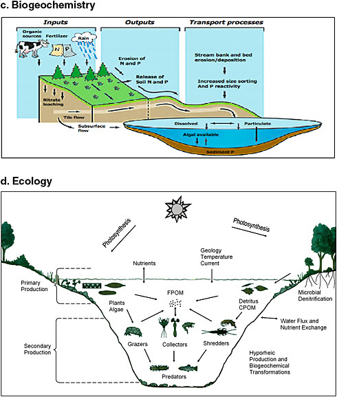
A full review of the major hydrologic, ecological, geomorphological, and biogeochemical processes important to river science is beyond the scope of this report. The reader is encouraged to consult the many excellent existing texts on these subjects (e.g., Brutsaert, 2005; Allen, 1995; Bridge, 2003; and Drever, 1997, respectively). However, graphical summaries of some of the key processes are shown in Figures 1-1a through 1-1d. These figures are also useful to visualize how rivers may be seen from the disciplinary perspectives of hydrologists, geomorphologists, biogeochemists, and ecologists.
While this report distinguishes between watershed science, which encompasses a broad range of human activities within watersheds, and the more narrowly defined river science, the social sciences play a direct role even in the latter. For example, the extraction of water from rivers or their floodplain sediments for human uses may alter hydrographs, influence sediment transport, and directly impact stream ecosystems. Economic or sociology may be incorporated into stream restoration science. Cultural geography may also have direct application to river science research.
River science not only spans multiple disciplines but also multiple spatial and temporal scales. Watersheds range in size from under a square kilometer to hundreds or thousands of square kilometers, and the physical and biological environment changes as a river travels from its headwaters to its outlet. Along this flow path, riverine units, such as reaches, orders, and subwatersheds, are linked in a nested hierarchy. Riverine processes inherit these hierarchical relationships. For example, small-scale or short-term physical processes may influence reach-scale habitat features that in turn mediate ecological processes at much broader scales and over longer time periods. Thus, river science analysis at multiple scales is often required to provide knowledge needed for predictive frameworks and to inform management and restoration decisions.
Because river science studies must include the spatial and temporal scales of operation that are relevant to the problems at hand, studies vary dramatically. For example, to assess how local fish populations might be affected by the deepening of the navigational channel of the lower Mississippi River, fish habitat studies might reasonably be confined to this stretch of river. In contrast, examining how sediment fluxes from the Mississippi River to the Gulf of Mexico have changed with time involves looking at potential sediment sources and transport processes throughout the entire river basin.
Because of its interdisciplinary focus on the physical, chemical, and biological processes affecting the stream channel, floodplain, and riparian corridor
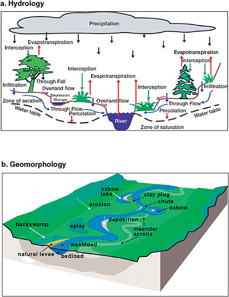
FIGURE 1-1 Four disciplinary perspectives of rivers from (a) hydrologists, (b) geomorphologists, (c) biogeochemists, and (d) ecologists. SOURCE: (a) ga.water.usgs.gov/edu/charts/water distribution.gif, (b) modified from http://www.epa.gov/watertrain/ecology/ecology18.html, (c) modified from http://www.epa.gov/watertrain/pdf/issue3.pdf, and (d) modified, with permission, from Cushing and Allen (2001). © 2001 by Elsevier.
through which the river flows, the domain of river science is not constrained by any arbitrary spatial scale or boundaries defined by the morphology of channels, floodplains, or terraces. Rather, the domain and bounds of river science are defined by the process bounds and characteristic spatial and temporal scales that are necessary to realize a predictive understanding. This interdisciplinary, process-based, multiscale approach to studying rivers distinguishes river science as an appropriate and increasingly valuable approach for supporting policy-relevant decision making for the nation.
THE USGS AND RIVER SCIENCE
The USGS’s mission to “serve … the Nation by providing reliable scientific information to describe and understand the Earth; minimize loss of life and property from natural disasters; manage water, biological, energy, and mineral resources; and enhance and protect our quality of life” (http://www.usgs.gov/aboutusgs/) suggests it is well positioned to play a key role in the future of river science. As the primary science agency of the Department of the Interior, the USGS has a responsibility to assist society in addressing science issues associated with rivers. The nature of the USGS as a national and nonregulatory agency enables the USGS to provide “policy relevant and policy neutral” information and understanding. In addition, river science spans traditional scientific disciplines where the core strengths of the USGS lay—hydrology and hydraulics, sediment transport, biology and ecology, aquatic chemistry, hydroclimatology, geology, and resource mapping. As such, the USGS is uniquely positioned among federal agencies to draw from the disciplinary expertise throughout its organization to provide needed integration and synthesis. This potential is highlighted in numerous reports including the NRC reports Research Opportunities in Geography at the U.S. Geological Survey (NRC, 2002a) and Assessing the National Streamflow Information Program (NRC, 2004d).
ADDRESSING THE STATEMENT OF TASK
The NRC’s Committee on River Science at the U.S. Geological Survey was asked to provide guidance and advice for the USGS’s vision for river science, in accordance with its statement of task presented in Box 1-1. This report contains the results of that study. Within Box 1-1 we highlight the chapters that address the particular tasks given the committee by the USGS.
The committee addresses the first task (i.e., to identify the highest priority river science questions for the USGS) in Chapter 4. This chapter proposes three topical areas for special emphasis, namely, environmental flows and river restoration, sediment transport and geomorphology, and groundwater and surface-water interactions. It also recommends two crosscutting science activities, namely, surveying and mapping the nation’s river systems according to key physical
|
BOX 1-1 Statement of Task The NRC will provide guidance and advice to the USGS on the following issues:
|
and landscape features, and expanding work on predictive models, especially those that simulate interactions between physical and biological processes.
Most of the second task (i.e., to identify key variables to be monitored and data-managed) is addressed in Chapter 5. Table 5-1 summarizes some key recommended variables. The chapter proposes enhancements in streamflow, biological, and sediment monitoring; these include establishing multidisciplinary,
integrated reach-scale monitoring sites and developing a comprehensive national sediment monitoring program. It also encourages the USGS to be at the forefront of new technology application, including airborne lidar and embedded, networked wireless sensors.
The answers to most elements of the third (which asks the committee to balance temporal and spatial scales, local intense studies vs. broad regional or national studies, and work on small, pristine streams vs. large, heavily impacted rivers) are topic specific. Thus, they are different for each individual recommendation. Establishment of the recommended reach-scale monitoring sites, and increased work in groundwater and surface-water interactions, imply local intense study of processes. In contrast, recommended river surveying and sediment monitoring programs would be national in scale and might last for many decades or even centuries. Overall, most of the recommended research areas, such as stream restoration, environmental flows, and models that predict ecological change, imply considerable work in highly altered rivers. However, most of these would benefit from and may require comparative sites in more pristine environments. Thus, the committee defers the details of this task to the USGS pending how it chooses to organize its scientific disciplines to most effectively address river science issues (see Chapter 6).
REPORT ORGANIZATION
The overall organization of the report is as follows. Chapter 2 first frames the broad societal issues that provide purpose for river science questions. That is, what are current challenges that make learning more about the science of rivers important? Chapter 3 describes the range of entities involved in river science, from the USGS and other federal agencies to state governments and nonprofit agencies, and details the unique role of the USGS in river science research. Then, with society’s needs, existing activities, and the USGS’s unique qualifications as a context, Chapter 4 outlines five important science priority areas the USGS should investigate to best be able to address key river science questions. Chapter 5 looks at the river monitoring and data management infrastructure that supports existing activities in river science and management and recommends an approach to handling the diversity of information and data needed to support the science priorities. Chapter 6 addresses how interdisciplinary river research might be augmented and coordinated at the USGS. Finally, Chapter 7 presents the committee’s conclusions and recommendations.


