
3
Emergency Management Framework
Intervention to address disasters has evolved through time into a complex policy subsystem, and disaster policy is implemented through a set of functions known as emergency management and response. Modern approaches to emergency management and response involve multidimensional efforts to reduce our vulnerability to hazards; to diminish the impact of disasters; and to prepare for, respond to, and recover from those that occur. These responsibilities present formidable challenges for governments because of the extraordinary demands disaster events impose on the decision-making systems and service delivery infrastructure of the communities they affect. Moreover, by definition an event constitutes a disaster if it exceeds the capacity of the government or governments in whose jurisdiction it occurs. Dealing with disaster therefore requires outside resources. In the context of a federally structured government, when the capacities of government jurisdictions at lower levels are overwhelmed, higher levels are called upon to assist, by either supporting or supplanting the activities of the subordinate jurisdictions. Likewise, assets and capabilities in the corporate and nongovernmental sectors may be brought to bear. As a result, emergency management and response are intrinsically intergovernmental, cross-sector policy implementation challenges. Also, since disasters dramatically affect our physical, social, and economic geography, geospatial requirements and capabilities are embedded throughout this complex system. This chapter describes the key characteristics of disasters and the conventional phased approach to their management, with particular attention to geospatial needs and functions.
3.1
THE CONTEXT OF DISASTERS
The paramount goal of disaster management activities is to reduce, as much as possible, the degree to which a community’s condition is worsened by a disaster relative to its pre-disaster condition. There are many actions undertaken by participants in disaster management that support this goal both pre-disaster (to forestall or reduce potential damage) and post-disaster (to recover from actual damage), and ideally these activities would reduce the potential effects of a disaster to the point of elimination. Yet the very nature of disasters makes this ideal unachievable. There are five major characteristics of disasters that make them hard to overcome (for a more detailed explanation, see Donahue and Joyce, 2001; Waugh, 2000):
-
Disasters are large, rapid-onset incidents relative to the size and resources of an affected jurisdiction. That is, they harm a high percentage of the jurisdiction’s property or population, and damage occurs quickly relative to the jurisdiction’s ability to avert or avoid it. They may also directly impact the resources and personnel available to respond. As a result, response to disasters evokes a profound sense of urgency, and coping with them drains a jurisdiction’s human resources, equipment, supplies, and funds. If pre-incident data are available, geospatial analysis can provide important insight into the nature and extent of changes wrought by disasters.
-
Disasters are uncertain with respect to both their occurrences and their outcomes. This uncertainty arises because hazards that present a threat of disaster are hard to identify, the causal relationship between hazards and disaster events is poorly understood, and risks are hard to measure—that is, it is difficult to specify what kind of damage is possible, how much damage is possible, and how likely it is that a given type and severity of damage will occur. Geospatial models can help predict the locations, footprints, times, and durations of events, and the damage they may cause, so that jurisdictions can better prepare for them.
-
Risks and benefits are difficult to assess and compare. Disasters present emergency planners, emergency managers, and policy makers with countervailing pressures. On the one hand, it is important to minimize the exposure of populations and infrastructure to hazards; on the other, people want to build and live in scenic, but hazard-prone, areas and often oppose government regulation. Further, how should the various levels of government address the balance between providing relief to the victims of disasters and the need or desire to avoid encouraging risk-accepting behavior; also, to what extent should the costs of such behavior be shifted from those who engage in this behavior to the larger population? While
-
most agree that response assistance should be provided to those who have suffered from a disaster, questions arise as to whether insurance for those in risk-prone areas should be subsidized by the federal government and to what extent repeated damage should be compensated (for example, by paying for rebuilding the same house after a second or third flood). An important component of this issue is the accuracy of risk assessment. Geospatial data and tools are invaluable in making the necessary assessments of the geographic distribution of risk and in estimating the quality of each assessment.
-
Disasters are dynamic events. Disasters evolve as they progress, and they change in response to human actions and natural forces. This makes it imperative that response strategies be flexible and argues for the value of analysis in helping responders understand and adapt to the changing conditions they face. Managing these phenomena can thus be a highly technical endeavor requiring specialized expertise for both policy development and policy implementation. In particular, geospatial data and tools can help incident managers to visualize the event over time, track the activities of responders, and predict the outcomes of various courses of action.
-
Disasters are relatively rare. Most communities experience few, if any, disasters during the average time in office of a political official or the average time of residence of a citizen. Thus, many communities are unlikely to have recent experience with disasters, and governments may feel little imperative to build their disaster-management capacity, even if the hazards are real and the risks formidable (Waugh, 1988). More obvious and immediately pressing public service concerns readily displace disaster preparedness as a priority. Specialized capabilities, such as geospatial data and tools, are especially vulnerable to budget cuts and resource reallocation.
These inherent qualities of disasters leave governments in a quandary about what to do to manage them. More specifically, the magnitude, scope, uncertainty, dynamism, and infrequency of disasters give rise to some important questions:
-
How can we increase the resilience of communities to disasters— for example, by adding levees, raising the elevation of the living floor in homes, or imposing zoning regulations?
-
How can we reduce the impact of disaster events—for example, through more effective warning systems or better evacuation plans?
-
How can we most effectively provide assistance to those who have been affected—through development of a common operating pic-
-
ture and common situational awareness shared by all emergency responders or through better search-and-rescue procedures?
Thus, we face both policy issues and practical challenges as we work to reduce the risk to which our populations are exposed and to protect people and infrastructure. Almost every emergency preparedness and response challenge has important geospatial aspects, and effective emergency management thus requires adroit use of geospatial data and tools.
To address these and other issues and challenges, the emergency services professions have specified a host of activities aimed at assuaging the losses that disasters inflict. The degree to which these activities have been identified, assigned to responsible parties, and coordinated has evolved over time into a broad framework first defined in a 1979 National Governors Association report on its study of emergency preparedness (National Governors Association, 1979). This approach, known as Comprehensive Emergency Management, specifies four phases of modern disaster management: preparedness, response, recovery, and mitigation. Each of these phases levies particular demands on emergency managers and responders, and each can be informed and improved by the application of geospatial data and tools. These phases follow one another in a continuous cycle, with a disaster event occurring between the preparedness and the response phases, as shown in Figure 3.1. For additional explanation of the emergency management process, see Waugh (2000) and Haddow and Bullock (2003).
3.1.1
Preparedness
Preparedness involves activities undertaken in the short term before disaster strikes that enhance the readiness of organizations and communities to respond effectively. Preparedness actions shorten the time required for the subsequent response phase and potentially speed recovery as well. During this phase, hazards can be identified and plans developed to address response and recovery requirements. Disaster plans are often developed by individual agencies, but one challenge of disasters is that they demand action from agencies and organizations that may not work closely together from day to day. Thus, plans are much more effective when developed collectively by all agencies that will be responding so that resources and responsibilities are coordinated in advance. Also during the preparedness phase, training and exercises may be conducted to help prepare responders for real events. These vary from conceptual discussions to more formalized tabletop exercises (TTXs), during which neither people nor equipment is moved, to field exercises (FXs), which simu-
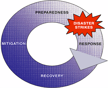
FIGURE 3.1 Emergency management cycle.
late real events. As with planning, training and exercises may be conducted by agencies in isolation, but they are more powerful when conducted jointly so that interfaces can be resolved. Perhaps the most important result of joint planning and exercising is the relationships developed between those who will be involved in response. In the best instances, these processes develop trust among those who will be called upon to work together during an event.
From the geospatial perspective, preparedness objectives include identifying data requirements, developing data sets, and sharing data across agencies. This includes activities as basic as developing framework data and foundation data on infrastructure, hazards and risks, location of assets that are of use for response and recovery (sand bags, generators, shelters, medical resources, heavy equipment, breathing apparatus, chemical spill response units, etc.), determining (if possible) common standards for data, making potentially difficult decisions about attributes, and compiling necessary metadata. Preparedness is greatly facilitated when all potential responding entities are working with the same data sets for the same features. Decisions also must be made as to whether data will be accessed from single sources or whether they will be hosted by some or all of the agencies involved in the response. Discussions about how
geospatial support will be provided (each agency supporting its own geospatial work or some form of sharing of human resources) should occur. Applications, such as web servers and services and databases related to specific recovery and response activities, should be developed. Decisions should be made about how data are to be reported (times, units, method, format), which agencies will be preparing reports, and where the data and information are located and how and by whom they can be accessed. If imagery is to be used during the response, this is the time to consider user requirements for each mission, imagery that will meet these requirements, whether imagery may meet multiple requirements, what steps will facilitate the acquisition of this imagery, and how and to whom the imagery will be distributed after it has been acquired.
In the preparedness phase, geospatial tools can be used to display the distribution of hazards and risks as they exist now and risks as they may exist under different future development scenarios. This enables local and regional planners to work with emergency managers to plan for more sustainable futures through the avoidance or mitigation of higher-risk alternatives. For example, evacuation routes can be planned based upon demographics, capacity of existing roads, and traffic volume as a function of day and time.
Models of event scenarios can be used either in the development of single- or multiagency response plans or as part of exercises designed to test agency preparedness and the adequacy of those plans. The scenarios are essential in developing the master scenario events lists (MSELs) that enable exercise designers and controllers to test critical aspects of response plans and to develop additional modifications of the course of events during an exercise. Models also can be used prior to the actual impact of an event (pre-landfall for hurricanes or prior to flood crest) to estimate potential numbers of fatalities, injuries, and damage to infrastructure, so that responding agencies can initiate activities as soon as it is safe to move into the impacted area. Wind-speed models for hurricanes can be used to estimate the extent of expected damage to buildings. Energy-infrastructure damage models can be used to estimate the likely extent of damage to the distribution grid, and water- and ice-demand models can be used to estimate initial daily demand for these commodities.
3.1.2
Response
Response activities are undertaken immediately following a disaster to provide emergency assistance to victims. The response phase starts with the onset of the disaster and is devoted to reducing life-threatening conditions, providing life-sustaining aid, and stopping additional damage to property. During this phase, responders are engaged in a myriad of ac-
tivities. As examples, search-and-rescue efforts are made to find individuals who may be trapped in buildings, under debris, or on roofs; basic commodities such as water and ice are distributed to affected populations; temporary power and shelters are established and provided; and fires and spills or leaks of hazardous materials are controlled. Although this phase is considered to begin when disaster strikes, not all disasters occur suddenly and without warning—sometimes onset is slower or anticipated, in which case response overlaps with the preceding preparedness phase and may include proactive steps such as warning and evacuation. Likewise, this phase has been defined historically as lasting 72 hours, but a clear end point for this period is difficult to define. It transitions into the recovery phase, and in reality response and recovery may overlap, especially during large, complex incidents.
Geospatial information and analysis are critical inputs to incident management and tactical decision making. Activities during this period include image acquisition, processing, analysis, distribution, and conversion to information products. Other geospatial data also must be collected, collated, summarized, and converted into maps, reports, and other information products. While sophisticated imagery and analysis are valuable to the response effort, the products most in demand are maps, including, for example, maps of the impact area and of the extent of damage; the locations of population in the impact area; the locations of assets to be used in the response, including inventories of critical supplies such as potable water and ice, temporary roofing material, medical supplies, and generators; maps of the area without power and of the timing of the return of power; and maps of road and bridge closures and downed power lines. Beyond this, products must also be useful and usable, which means that quality assurance and quality control (QA/QC) procedures and accurate metadata are essential. Attention must be given to reducing errors that arise when data are collected by different entities, or at different times, and then integrated into information products. Agreements need to be made regarding data reporting intervals and times, and data have to be time-stamped accurately. Finally, generation of data, information, and products is only part of the challenge—these must then be distributed to those who need them to do their jobs. Geospatial data are often voluminous, and this is especially true of imagery, which may amount to hundreds of megabytes or even gigabytes. Moving such volumes of data over networks that may have been partially disabled can be problematic, and Internet access to data repositories often fails. Firewalls and other security software installed on networks can also pose problems for the distribution of data and can significantly slow response. Agencies have often had to resort to physical distribution of CDs (compact discs) and other digital media during the response phase.
During the response phase immediately following an event, but prior to good information being available either from remote-sensing sources or from reporting on the ground, geospatial models can be used to provide damage estimates (e.g., immediately after an earthquake). Alternatively, real-time data from in situ monitoring can be used with geospatial models to determine conditions during an event, such as the use of real-time stream gauge data to issue flood warnings or the use of Doppler radar data, which results in the issuance of public warnings for severe thunderstorms and tornadic activity. While both imagery and verified reports from the impact area will eventually replace and refine the information provided by models, the latter may be the best source of information for several days after the onset of the disaster. Use of dynamic models can help guide and improve response; for example, the wildfire community makes extensive use of real-time and near-real-time geospatial modeling of wildfire behavior for logistical support. Display functions remain important at this time, showing the location of damage to specific infrastructure components (e.g., the transportation and energy infrastructure) as well as the severity of damage and other specific information (e.g., damage to roofs, temporary repairs, and energy grid restoration planned during the next 24 hours).
Accomplishing all of these tasks is admittedly a substantial challenge in the earliest stages of disaster response, when demands are urgent and requests are voluminous. Poor products can have serious negative ramifications for response and recovery operations, however. For geospatial professionals to perform well in this environment, they must be able to rely on good training, relevant exercise experience, and sound standard operating procedures.
3.1.3
Recovery
Recovery includes short- and long-term activities undertaken after a disaster that are designed to return the people and property in an affected community to at least their pre-disaster condition of well-being. In the immediate term, activities include the provision of temporary housing, temporary roofing, financial assistance, and initial restoration of services and infrastructure repair. Longer-term activities involve rebuilding and reconstruction of physical, economic, and social infrastructure and, ultimately, memorializing the losses from the event.
Geospatial activities during recovery include the use of geospatial information and analysis to help managers direct the recovery process, including the urban search-and-rescue grid and status, tracking the progress of repairs, provision of temporary water and ice, locating populations,
identifying sites for temporary housing and services, and showing the operational status of hospitals and clinics.
An important task is capturing and archiving data collected as part of the disaster, along with copies or descriptions of the procedures that were used to turn those data into information and to distribute the information, and documentation of lessons learned from the disaster. These data can be used to inform mitigation planning and research about disaster processes. Too often, however, archiving is given short shrift and valuable data are lost.
3.1.4
Mitigation
Mitigation includes those activities undertaken in the long term after one disaster and before another strikes that are designed to prevent emergencies and to reduce the damage resulting from those that occur, including identifying and modifying hazards, assessing and reducing vulnerability to risks, and diffusing potential losses. In short, it is a set of sustained activities designed to reduce the impacts of future disasters. Mitigation involves implementing policy changes and new strategies. Some of these activities may be structural in nature, such as changing building codes (e.g., to require that residential buildings be able to resist sustained wind speeds of 150 miles per hour [mph] rather than 120 mph, to require fastening roofs to bearing walls). Mitigation measures also can be nonstructural. For example, zoning can be used to preclude development in areas that are subject to risk from a hazard.
Geospatial assets can inform mitigation planning in important ways, perhaps most importantly the opportunity to visualize and measure the effects of alternative mitigation plans. Simulation models (e.g., to model the inundation area that will result from various stream elevations with and without the presence of levees or to predict the propagation of hazardous materials in the atmosphere) can help planners make redevelopment decisions. Geospatial analysis can support benefit-cost analysis by comparing the cost of changes (such as new construction requirements) to estimates of the savings that result when a hazard is mitigated. Geospatial tools are of particular benefit due to their ability to permit the evaluation of multiple alternatives relatively rapidly.
3.1.5
Additional Comments
The cycle shown in Figure 3.1 is clearly simplified, since events can occur at any time and may overlap. Different organizations come into play in different phases, creating a complex web of interactions. Recovery and mitigation may not be complete before another event occurs, and the
necessary funds to support them may not be fully available prior to the next event. Further, as the ability to organize multiagency efforts continues to improve, some of the actions that have traditionally been thought of as recovery activities are now beginning at essentially the same time as the response. In theory, preparedness should reduce the time from the initiation of response to the end of recovery. Mitigation should reduce the cost of future disasters of the same type at the same location, and lessons learned should be incorporated into planning and mitigation in other areas, thereby reducing impacts elsewhere.
A modification of this paradigm is used for acts of terrorism where awareness, detection, deterrence, and prevention are seen as the key elements in reducing or eliminating the impacts or even the occurrence of events. Specific emergency management activities may differ for those described above as they are influenced by the intelligence and security communities, but the sequence is analogous to that followed for natural disasters and has elements that parallel what is required for technological disasters. For these events, intelligence must be collected about risks posed by individuals and groups that may seek to harm people or critical infrastructure. In parallel to preparedness and mitigation, techniques are developed to deter or reduce the effectiveness of attacks so that the consequences are reduced. In ideal cases, populations and infrastructure are rendered invulnerable to attacks. Again, geospatial data and tools can be used to show conditions at particular points in time. It is possible to model the consequences of various forcing mechanisms (attacks rather than wind speed or flooding) on the existing infrastructure under a range of response and deterrence mechanisms.
3.2
RELEVANT ACTORS
3.2.1
Emergency Managers and Responders
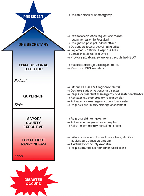
The catastrophic nature of disasters means that all levels of government and all sectors of society share responsibility for dealing with them. In general, disasters are managed through a federal structure of responsibilities and resources, where discretion and authority for management reside with the affected jurisdictions, and where requests for resource support travel upward from those jurisdictions until enough are garnered to stabilize the incident. Table 3.1 identifies the major functions of each level of government during each phase of the disaster management process.
It is often said that “disasters begin and end at the local level.” The effects of disasters are felt by people living in communities, and ultimately the efforts of emergency services professionals focus on restoring the health of communities. Disasters are fundamentally local in impact; thus,
responsibility for the management of response resides with states and local governments. Local responders provide the first response in communities, focused on initial efforts to save lives and property. As jurisdictions are overwhelmed, neighboring jurisdictions may assist through the provision of mutual aid. Nongovernmental organizations (both private and nonprofit) also supplement response with a range of assistance from providing shelter and food to helping manage donations of money, goods, and services, to tracking and serving populations with special needs. Figure 3.2 describes the sequence of events for response.
For larger incidents, impacts can extend to regional or even national levels, as was the case with Hurricanes Katrina, Rita, and Wilma in 2005, and the Space Shuttle Columbia crash in 2003. If local jurisdictions find they cannot manage the demands of an incident, they turn to their state government for assistance. State emergency managers coordinate local communities, state agencies, assets controlled by the governor (such as the state national guard), and support from other states and the federal government. They assess damage and resource needs, and then obtain and allocate required resources. If the size and scope of the incident warrant, the governor may request a disaster declaration.
In the event of a request for a disaster declaration, or if the disaster is national in significance or scope, the President may decide to bring the resources of the federal government to bear. These resources are generally coordinated by the Department of Homeland Security (DHS) under the National Response Plan (NRP).1 The NRP “is an all-hazards plan that provides the structure and mechanisms for national level policy and operational coordination for domestic incident management.” It provides the framework for federal interaction with other levels of government and other sectors with respect to all phases of disaster management (preparedness, response, recovery, and mitigation) and describes federal capabilities, resources, agency roles, and responsibilities.
One critical function of emergency responders at all levels of government is incident management. Incident management refers to the collection of command-and-control activities exercised to prepare and execute plans and orders designed to respond to and recover from the effects of an emergency event. It is usually effected through a functionally oriented incident command system (ICS) that can be tailored to the type, scope, magnitude, complexity, and management needs of the incident and can operate at all levels of government. An ICS is employed to organize and unify multiple disciplines, jurisdictions, and responsibilities on-scene un-
TABLE 3.1 Key Disaster-Related Functions by Level of Government and Phase
|
Level |
Mitigation |
Preparedness |
|
Federal |
|
|
|
State |
|
|
|
Response |
Recovery |
|
|
|
|
der one functional organization. The ICS establishes lines of supervisory authority and formal reporting relationships, but allows for team-based leadership approaches. In particular, the ICS may include the adoption of a formal unified command, a multiagency governance structure that incorporates officials from agencies with jurisdictional or functional responsibility at the incident scene and allows them to provide management and direction jointly within a commonly conceived set of incident objectives and strategies. Regardless of whether the ICS is configured as a unitary or a unified command, the ICS organization develops around five major functions that are required for any incident whether it is large or small:
-
Command. The incident commander’s (IC’s) responsibility is overall management of the incident. On most incidents the command activity is carried out by a single IC. The IC determines incident objectives and strategy, sets immediate priorities, establishes an appropriate organization, authorizes an Incident Action Plan, coordinates activity for all com-
|
Response |
Recovery |
|
|
-
mand and general staff, ensures safety, coordinates with key people and officials, authorizes release of information to the news media and the public, and performs other key duties.
-
Operations. Operations refers to the ways in which resources are applied in the field to meet emergency response objectives. In an ICS, the operations section is responsible for directing and supervising the execution of all tactical activities. Operations chiefs also coordinate activities with other entities, ensure safety, and request and release resources. Operations are often facilitated by an associated planning process.
-
Planning. This function involves the collection, evaluation, processing, and dissemination of resource and situational incident information. This information informs the Incident Action Plan, which specifies how all incident operations will proceed. Geospatial assets are typically incorporated as part of the plans section, often through the use of technical specialists who provide a particular level of expertise necessary to properly manage the incident.
-
Logistics. This function incorporates all incident support needs, including supplies, facilities, transportation, communications, food, and medical support. It is the logistics section’s responsibility to establish the infrastructure required to meet the data management needs that arise as geospatial data and tools are brought to bear on an incident.
-
Finance and Administration. This function includes activities such as procurement, timekeeping, compensation, claims processing, and cost management. Should geospatial data and tools be required to support an incident, this section would be responsible for procuring them.
While the concept of incident command has been developed over more than three decades and is broadly employed, different disciplines and jurisdictions understand and implement ICS differently. Also, as the committee heard in accounts of incident after incident, the implementation of a coherent command structure for a large-scale disaster is a substantial challenge. Very often, multiple, overlapping, duplicative, and even conflicting command processes and structures emerge. This, in turn, makes coordination and application of geospatial resources difficult. The National Incident Management System (discussed below) attempts to address these tensions by incorporating longstanding ICS and unified command principles into a common incident management operating philosophy.
3.2.2
Public Sector Geospatial Support
Emergency services professionals, from those operating tactically at the front line to those working strategically at higher levels of government, are aided in their incident management responsibilities by a variety of geospatial experts using data and tools and working at various sites to support response and recovery. In the public sector, these geospatial experts reside in numerous federal agencies and national laboratories and in state and local governments. The role that each plays in emergency management activities varies according to the mission of the organization and is described in this section.
The federal agency whose mission is most closely involved in emergency management is the Department of Homeland Security. Since this agency was established in 2002, its development and operation of disaster management policy and functions are dynamic and still evolving. Nevertheless, from the geospatial policy perspective, DHS’s Geospatial Management Office (GMO) was established by the Intelligence Reform and Terrorism Prevention Act of 2004,2 section 8201 “Homeland Secu-
rity Geospatial Information.” The GMO is responsible for (1) coordinating the geospatial information needs and activities of the department; (2) implementing standards to facilitate the interoperability of geospatial information pertaining to homeland security among all users of such information within DHS, state and local governments, and the private sector; (3) coordinating with the Federal Geographic Data Committee and carrying out the responsibilities of DHS pursuant to Office of Management and Budget (OMB) Circular A-16 and Executive Order 12906; and (4) making recommendations to the secretary and the executive director of the Office for State and Local Government Coordination and Preparedness on awarding grants to fund the creation of geospatial data and execute information-sharing agreements regarding geospatial data with state, local, and tribal governments.
The GMO’s major initiatives include publication of a draft Geospatial Data Model (May 2006),3 developing geospatial guidance for DHS’s grant program, developing a geospatial concept of operations for the National Response Plan, and publication of a national geospatial strategy to meet national geospatial preparedness needs. Of note is that by 2007, the office is supposed to be able to provide oversight of all geospatial IT (information technology) systems management, procurement, security, and interoperability issues at DHS.
The office has only a handful of staff and is currently funded at about $13 million. Given its broad mission and ambitious agenda, these resources seem inadequate. In fact, the DHS inspector general has noted that the GMO has “used a ‘do no harm’ approach—leaving legacy agencies within DHS … to manage as they deem appropriate,” with the result that other DHS component managers are stalled, unsure when to coordinate with the GMO and when to act on their own (DHS, 2005, p. 22). This may be a symptom of the fact that the office is underfunded and understaffed. It is the sense of the committee that this office and its initiatives are relatively new and have not yet matured into a robust geospatial organization at DHS. It will be very important for geospatial capacity to be a strong component of DHS activities, both operationally (as part of the National Operations Center described below) and analytically (as part of efforts such as infrastructure protection).
Other DHS agencies also are involved in geospatial activities. Since July 2004, DHS has continuously operated a standing Homeland Security Operations Center (HSOC), designed to serve as a center for information sharing and domestic incident management and to help coordination be-
tween federal, state, territorial, tribal, local, and private-sector entities. The White House views the HSOC as the primary federal-level command and control “hub for operational communications, information sharing and situational awareness for all information pertaining to a domestic terrorist or disaster incident.” The HSOC collects and fuses information from a variety of sources and provides real-time situational awareness and monitoring nationwide. It also coordinates incidents and response activities and, in conjunction with the DHS Office of Information Analysis, issues advisories and bulletins concerning threats and specific protective measures. Information on domestic incident management is shared with emergency operations centers (EOCs) at all levels using the Homeland Security Information Network (HSIN). The HSOC reports receiving hundreds of calls and managing about 22 cases per day. To accomplish its missions, HSOC relies on “watchstanders” from 35 agencies, including the National Geospatial-Intelligence Agency, the National Oceanic Atmospheric Administration (NOAA), and the DHS Geospatial Management Office. The efficacy of the center has come under scrutiny since Hurricane Katrina. The 2006 report by Congress, A Failure of Initiative: Final Report of the Select Bipartisan Committee to Investigate the Preparation for and Response to Hurricane Katrina,4 for example, notes that the center “failed to provide valuable situational information to the White House and key operational officials” during the storm. DHS is currently considering consolidating HSOC functions with those of other federal operations centers to form a National Operations Center.
In direct support of the HSOC and incident management, DHS relies on the ability to formulate a common operating picture (COP), driven by fused data sources and types and shared geospatial data and services, in order to facilitate situational awareness. Development of the COP is an important job of the GMO. In the future, DHS hopes to use its COP capabilities to support forecasting, modeling, and decision aids.
DHS also relies on its Interagency Modeling and Atmospheric Assessment Center (IMAAC) to serve as the “central provider” of atmospheric dispersion and hazard predictions for use by federal agencies and by state and local governments during incidents of national significance. The IMAAC is designed to assess atmospheric hazards relating to releases of chemical, biological, radiological, nuclear, and/or high-explosive materials. Following an atmospheric release event, IMAAC produces, coordinates, and disseminates consequence predictions in near real time to federal, state, and local responding agencies. In this way, responders will
share an up-to-date common operating picture based on accurate, unambiguous hazard prediction models. DHS’s vision is that the modeling products produced by IMAAC will be based on a combination of location-specific meteorological data, demographic data, and on-site observations garnered through the collaboration of various federal partners. The IMAAC concept has not yet been fully developed or implemented. In the interim, Lawrence Livermore National Laboratory’s National Atmospheric Release Advisory Center is serving as a technical and functional example for IMAAC.
Geospatial professionals directly involved in emergency management work primarily in other capacities during normal times outside of disaster response and recovery, although this varies by agency and level of government. At the federal level, the Federal Emergency Management Agency (FEMA) has geospatial professionals who produce maps and analyses at the Mapping and Analysis Center (MAC) located at FEMA headquarters. This group generates products that track damage, demographic changes in damage areas, and other information of interest to policy makers. Staffing of this group is relatively small (approximately five people). In the field during an incident, FEMA supports its Joint Field Offices (JFOs) with a team of geospatial professionals as part of the plans section. From testimony, the committee learned that most of FEMA’s geospatial personnel are not full-time permanent employees but reservists with geospatial skills who are called upon to staff JFOs during events. The number of reservists available has varied, and recent experience during the 2004 and 2005 hurricane seasons indicates that the number of trained professionals who can provide sustained support for large events is insufficient. Moreover, because reservists change from event to event, it is difficult for FEMA to build robust, stable geospatial teams that work together well and have a consistent understanding of their mission. Finally, it usually takes several days or even weeks for FEMA’s geographic information system (GIS) section to be established at the JFO. Moreover, the GIS section does not deploy as a unit that is ready to work when it arrives on-site. Instead, a GIS team leader deploys and then assembles the personnel and equipment needed for the section. As a result, FEMA’s ability to provide geospatial support can be significantly delayed. Delays in getting adequate equipment, data, and software on-site often further hinder FEMA’s GIS support at the JFO. Meanwhile, state and local geospatial staffs have already begun work coordinating geospatial resources and developing products. It can be difficult for FEMA’s GIS section to integrate its support with these ongoing efforts. In addition, some response problems end up being solved without the benefit of technology that FEMA might have brought to bear, had it been on-site and operational sooner. The committee was told that in 2006, FEMA would be test-
ing a geospatial strike team approach by sending professionals to a disaster area to meet immediate mapping and analysis needs. The strike team would move out to be replaced by longer-term personnel as response and recovery activities proceed.
Other federal agencies and national laboratories also have geospatial resources, including personnel, data, and tools that can be brought to bear during disasters. The roles of the other federal agencies in emergency management and their use of geospatial data and tools are very diverse, depending on the mission of the agency. One important player is the U.S. Army Corps of Engineers, which has no geospatial professionals dedicated to emergency management, but has created a cadre of GIS professionals trained in the missions performed by the Corps under the National Response Plan and in support to FEMA at the JFOs. The National Oceanic and Atmospheric Administration is very involved in weather-related emergencies, providing a wealth of geospatial data and tools. The NOAA National Weather Service GIS Data web site5 is but one example of the types of data that it makes available. The National Geospatial-Intelligence Agency (NGA) can be tasked by FEMA to provide imagery and geospatial analysis for disaster response, as it did during Hurricane Katrina. The U.S. Geological Survey (USGS) makes all of its geospatial data available through various means for use during incidents and has been asked by FEMA to help coordinate geospatial data efforts among federal agencies. A recent example of this is the partnership between USGS, NGA, and DHS to collect data for hurricane response, called GIS for the Gulf, which is being made accessible through the Geospatial One-Stop. The Environmental Protection Agency (EPA) performs various functions such as removing hazardous wastes from sites, risk assessments, and environmental sampling of drinking water, air, and sediments, and uses geospatial data and tools for supporting these functions. The U.S. Forest Service is very advanced in the use of geospatial data, tools, and models for wildfire response. National Aeronautics and Space Administration (NASA) remote-sensing data are used not only for response activities, but also for monitoring, modeling, and predicting natural phenomena. NASA works collaboratively with other agencies in developing applications and tools for disaster management. Although there are many more, these examples provide a feel for the broad range of geospatial activities related to emergency response carried out by the federal agencies.
At the local level, municipalities may have up to three dedicated geospatial professionals for emergency management activities, but most
small towns have none. Large cities often have their own GIS departments, and cities such as New York have GIS operations that are dedicated to emergency management. State emergency management agencies typically have up to seven geospatial professionals, but also often have their own GIS operations for other purposes such as environmental management or conservation and may draw upon this group of professionals during a disaster event.
Aside from the direct technical support that geospatial professionals provide, they are also in a position to play an important role in helping disaster managers and incident commanders think about how to define their geospatial requirements. In some cases, response professionals are not familiar with imagery, so they are unsure what is available that can help them, or they are unable to frame their questions effectively. In other cases, responders “have just enough information to be dangerous,” thinking they need something that will not actually help to solve their problems. Also, sometimes responders ask for the wrong thing, which then fails, leading them to condemn geospatial technology as unworkable or inappropriate. To bring geospatial data and tools to bear effectively then, geospatial professionals must be conversant in how to define functional requirements and must be willing and able to engage their responder customers in a way that will help the customers to articulate their problems and needs, so that the GIS unit can respond to them.
3.2.3
Geospatial Support from Universities and the Private Sector
Another repository of relevant expertise is at universities and private-sector companies. Researchers and graduate students often support city, regional, and state planning departments, and they may become fully integrated into activities occurring during a disaster. Similarly, private-sector corporations often provide professionals to assist governments in their response. For example, following the events of September 11, 2001, assorted specialists and volunteers from universities relocated to Pier 92 to contribute to the city’s geospatial response component, and various private-sector organizations proffered an array of technical capabilities and products to FEMA and the City of New York (see Section 2.1.1).
Private industry is also a large provider of geospatial information for emergency management, primarily in the area of aerial photography or other airborne remote sensing (light detection and ranging [LIDAR], thermal imaging, hyperspectral data) and satellite imagery. These data are vital for assessing impacts and damage immediately following an event and for supporting response and recovery activities. They also can be used for risk and vulnerability assessments in mitigation and preparedness phases. Section 4.6 describes the use of these types of data in more detail.
Some of the data necessary for emergency response, such as critical infrastructure data, are developed and maintained by the private sector.6 Estimates from the Department of Homeland Security’s Protected Critical Infrastructure Information (PCII) Program are that the private sector owns and operates 85 percent of the nation’s critical infrastructure.7 However, use of private-sector utility data is often very restricted. Issues with the use of these types of data are discussed in Chapter 4.
3.2.4
International Activities
The committee also queried members of the international emergency response community about geospatial needs. They largely echoed the needs expressed by responders in the United States and, in addition, cited key gaps in the global coverage of framework data and problems in preparing for and responding to emergencies that span national boundaries. Also, metadata at multiple levels are lacking, and as a result, there is poor harmonization among users. Attempts have been and are being made to address this problem.
There are numerous international activities in the area of geospatial data for emergency response, and much could be learned from them. Although it was beyond the scope of this study to analyze these activities in detail, a few are mentioned here as examples. The European Union Research and Development Programme has had programs running for many years on the specific role of geospatial information in disaster management, particularly in the Sixth Framework Programme.8 The Emergency Planning College in the United Kingdom has recently published A Guide to GIS Applications in Integrated Emergency Management (MacFarlane, 2005). International efforts to support the development of a Global Disaster Information Network9 (GDIN) were initiated in 1998. Subsequent meetings have been held to bolster this effort, and GDIN now exists as a voluntary self-sustaining nonprofit association. Moreover the Indian Ocean tsunami of 2004 created significant international interest in a warning network for such disasters. An excellent summary of lessons learned from the Indian Ocean tsunami regarding the deployment of geospatial data and tools in sudden-onset emergencies can be found in Kelmelis et al. (2006).
The Civil Military Emergency Preparedness Program is an ongoing effort funded by the Department of Defense that is focused on former Warsaw Pact countries. This program has developed an on-line geospatial data and map server available through the Partnership for Peace (PfP) Information Management System10 (PIMS). It presently includes an interface that provides multiscale access to data for these countries at a variety of levels of geographic detail from 1:2,000,000 to 1:10,000 that have been contributed by some of the participating countries. Low- and high-resolution imagery is also available. Other important activities include the North Atlantic Treaty Organization’s (NATO’s) Euro Atlantic Disaster Response Coordination Center11 (EADRCC) located at NATO Headquarters in Brussels, and the United Nations’ nongeospatial database of response resources that has been provided by each participating nation.
3.3
FEDERAL POLICY RELEVANT TO GEOSPATIAL REQUIREMENTS
As described above, demands imposed by disasters have prompted the evolution of emergency management into a formal set of activities assigned to responsible parties and coordinated across governments. Practices and policies have evolved over decades, and organizations and agencies, such as the Red Cross and Civil Defense, and emergency services, such as police and fire departments, have evolved a complex system of practices and procedures. However, the events of September 11, 2001, further crystallized these responsibilities. The Bush administration immediately established an Office of Homeland Security, and slightly more than a year later, the Department of Homeland Security was created. The DHS mission is stated as follows: “We will lead the unified national effort to secure America. We will prevent and deter terrorist attacks and protect against and respond to threats and hazards to the nation. We will ensure safe and secure borders, welcome lawful immigrants and visitors, and promote the free-flow of commerce.” To meet this mission, DHS has implemented a National Incident Management System12 (NIMS) and an updated NRP.13 These and other recent federal-level policy documents explicitly recognize the requirement to make geospatial data and tools available to support incident management. This section will identify the major policies and plans that currently guide
incident management and emergency response and their requirements related to geospatial data and tools.
3.3.1
National Strategy for Homeland Security14
This strategy, issued by President Bush in July 2002, sought to articulate the administration’s vision for homeland security policy and to provide direction and guidance to agencies at all levels of government. It states that “the strategic objectives of homeland security in order of priority are to prevent terrorist attacks within the United States, reduce America’s vulnerability to terrorism, and minimize the damage and recover from attacks that do occur.” In support of this, it identifies information sharing as a foundation for achieving these objectives and explicitly cites the National Spatial Data Infrastructure (NSDI) as “a working example of compiling metadata to facilitate integration of data and support decision making.” The NSDI (called for in Executive Order 12906,15 issued by President Clinton in April 1994) is designed to be a network of federal, state, and local geospatial databases (NRC, 1993). The National Strategy for Homeland Security envisioned that the NSDI, as part of President Bush’s e-government initiative, would include geospatial products, information, and enhanced metadata that would be coupled with incident management tools to allow real-time creation and display of maps and satellite images. Section 4.1 describes the current status of the NSDI as it pertains to emergency management.
3.3.2
Homeland Security Presidential Directive 7 (HSPD-7)
HSPD-7 establishes national policy on critical infrastructure identification, prioritization, and protection.16 Section 31 directs the Secretary of Homeland Security to collaborate with other federal departments and agencies to develop a program to “geospatially map, image, analyze, and sort critical infrastructure and key resources by utilizing commercial satellite and airborne systems, and existing capabilities within other agencies.” It allows for use of “national technical means,” or classified imagery gathered by certain defense and intelligence agencies, as a last resort. In June 2006, DHS published a National Infrastructure Protection Plan (NIPP),17 which says: “The Intelligence Community, the Department of
Defense, and other appropriate Federal departments, such as the Department of the Interior and DOT, are collaborating with DHS on the development and implementation of a geospatial program to map, image, analyze, and sort critical infrastructure/key resource (CI/KR) data using commercial satellite and airborne systems, as well as associated agency capabilities. DHS works with these Federal departments and agencies to identify and help protect those positioning, navigation, and timing services, such as global positioning systems (GPS), that are critical enablers for CI/KR sectors such as Banking and Finance and Telecommunications. DHS and the intelligence community also collaborate with other agencies, such as the EPA, that manage data addressed by geographic information systems.” As part of this effort, it has developed a National Asset Database (NADB), which integrates geospatial resources, and is working on revising this. According to the NIPP, “The current NADB incorporates a flexible design to facilitate evolution, growth, and continued interconnectivity with additional databases and tools. Advancements will include integration with multiple commercial and Federal CI/KR databases, vulnerability assessment tools and libraries, intelligence and threat reporting databases, and geospatial tools into a single, integrated, Web-based portal.”
3.3.3
National Response Plan
In December 2004, the Department of Homeland Security updated the National Response Plan to respond to objectives specified by the President in HSPD-5,18 which directed DHS “to align Federal coordination structures, capabilities, and resources into a unified, all discipline, and all-hazards approach to domestic incident management.” The NRP is the successor to (and supersedes) several other major plans, including earlier versions of the National Response Plan, the Domestic Terrorism Concept of Operations Plan, and the Federal Radiological Emergency Response Plan. The NRP adopts and adapts many of the functions and requirements detailed in those plans, including those related to geospatial data and tools. The NRP “is an all-hazards plan that provides the structure and mechanisms for national level policy and operational coordination for domestic incident management.” It is designed to be partially or fully implemented either prospectively, in the presence of a threat or anticipation of a significant event, or retrospectively, in response to a significant event. The NRP also seeks to provide the framework for federal interac-
tion and integration with other levels of government and other sectors with respect to all phases of disaster management. It describes federal capabilities, resources, and responsibilities, making reference to geospatial responsibilities in some cases. Importantly, the scope of the NRP is limited to federal departments and agencies that may provide assistance or conduct operations in actual disasters or other potential incidents of national significance, which it defines as “high-impact events” that require a coordinated response by a combination of federal, state, local, tribal, private-sector, and nongovernmental entities.
The NRP has five main components:19
-
The base plan, which “describes the structure and processes comprising a national approach to domestic incident management designed to integrate the efforts and resources of Federal, State, local, tribal, private-sector, and nongovernmental organizations”;
-
Appendixes, which provide definitions and details;
-
Emergency support function (ESF) annexes, which “detail the missions, policies, structures, and responsibilities of Federal agencies for coordinating resource and programmatic support to States, tribes, and other Federal agencies or other jurisdictions and entities during Incidents of National Significance”;
-
Support annexes, which describe administrative processes designed to facilitate plan implementation; and
-
Incident annexes, which address how the NRP is applied to particular contingencies or hazards.
Geospatial requirements appear in the ESF, support, and incident annexes as follows:
-
Emergency Support Function 5—Emergency Management Annex. This annex specifies that DHS-FEMA, as the primary responsible agency, “coordinates the use of remote sensing and reconnaissance operations, activation and deployment of assessment personnel or teams, and Geographic Information System support needed for incident management.” This annex also provides for the planning function in accordance with the NIMS. Specifically, ESF 5 “provides for the collection, evaluation, dissemination, and use of information regarding incident prevention and response actions and the status of resources.” ESF 5 states that one of the functions of the planning section is to coordinate “with the DHS Science and Technol-
-
ogy Directorate and agencies with special technical capabilities to request support for geospatial intelligence, modeling, and forecasting.”
-
Emergency Support Function 11—Agriculture and Natural Resources Annex also makes reference to geospatial data. It specifies that with respect to the protection of natural and cultural resources and historic properties and to animal and plant disease pest response, the Department of Agriculture is responsible for coordinating with the Department of the Interior for relevant mapping and geospatial data and assessment tools. This annex also says that with respect to the safety and security of the food supply, the Department of Agriculture “provides Geographic Information Systems mapping capability for the meat, poultry, and egg product facilities it regulates to assist State and local authorities to establish food control zones to protect the public health.”
-
Emergency Support Function 12—Energy is intended to restore damaged energy systems and components during a potential or actual incident of national significance. Under Department of Energy leadership, “ESF #12 provides information concerning the energy restoration process such as projected schedules, percent completion of restoration, geographic information on the restoration, and other information as appropriate.”
-
Emergency Support Function 13—Public Safety and Security Annex provides for NASA geospatial modeling capabilities to be used as available.
-
The Tribal Relations Support Annex specifies that federal departments and agencies are responsible for providing “appropriate incident management officials with access to current databases containing information on tribal resources, demographics, and geospatial information.”
-
The Nuclear/Radiological Incident Annex specifies that the Department of the Interior “advises and assists in the development of geographic information systems databases to be used in the analysis and assessment of contaminated areas, including personnel and equipment.”
Overall, the committee believes that the NRP is weak in defining geospatial requirements and providing federal agencies specific direction about how to meet them, and that DHS’s Geospatial Management Office should accelerate its plan to develop a geospatial concept of operations for the NRP.
3.3.4
National Incident Management System
The NIMS “provides a consistent doctrinal framework for incident management at all jurisdictional levels, regardless of the cause, size, or complexity of the incident.” The NIMS provides a core set of doctrine,
concepts, terminology, and organizational processes designed to promote effective, efficient, and collaborative incident management.
The NIMS rests on the well-established and broadly accepted ICS, which is employed to organize and unify multiple disciplines, jurisdictions, and responsibilities on-scene under one functional organization that directs incident operations. The ICS is classically organized into five major functions (command, operations, logistics, planning, and finance and administration; see Section 3.2.1). The NIMS suggests a sixth function, information and intelligence, which explicitly includes the analysis and sharing of geospatial data. The NIMS assigns responsibility to DHS’s NIMS Integration Center (NIC) for facilitating the development of data standards for geospatial information, asserting that “the use of geospatial data must be tied to consistent standards because of the potential for coordinates to be transformed incorrectly or otherwise misapplied, causing inconspicuous, yet serious, errors.” The NIMS sets forth the requirement that standards should be “robust enough to enable systems to be used in remote field locations, where telecommunications capabilities may not have sufficient bandwidth to handle large images or are limited in terms of computing hardware.”
3.3.5
National Preparedness Goal
HSPD-8 focuses on strengthening preparedness,20 and one of its requirements is the establishment of a national domestic all-hazards preparedness goal. This goal, developed with a capabilities-based planning approach habitually used by the military, is supposed to guide all levels of government, nongovernmental organizations, and the public “in determining how to most effectively and efficiently strengthen preparedness for terrorist attacks, major disasters, and other emergencies.” An interim goal was published in March 2005 and “establishes the national vision and priorities that will guide our efforts as we set measurable readiness benchmarks and targets to strengthen the Nation’s preparedness.”21 As of the October 2005 draft, neither the national preparedness goal nor the accompanying guidance that provides instructions on how to implement the goal addresses the nature or role of geospatial data or tools in preparedness.
According to the guidance, the goal is intended to be applied in conjunction with DHS’s National Planning Scenarios and Target Capabilities
|
20 |
http://www.whitehouse.gov/news/releases/2003/12/20031217-6.html. |
|
21 |
National Preparedness Goal (March 31, 2005); see http://www.ojp.usdoj.gov/odp/assessments/hspd8.htm. |
List (TCL). The TCL identifies the capabilities required to perform the critical tasks identified in a Universal Task List (UTL), which provides a menu of tasks that may be performed in major events such as those illustrated by the National Planning Scenarios. Among these tasks, some are deemed critical. The UTL and TCL make only scant reference to geospatial data and tools, as follows:
-
Universal Task List. Version 2.1 of the UTL was published in May 2005.22 The UTL identifies approximately 1,600 tasks, of which 300 are deemed “critical.” Critical tasks are defined as “those that must be performed during a major event to prevent occurrence, reduce loss of life or serious injuries, mitigate significant property damage, or are essential to the success of a homeland security mission.” The UTL identifies one geospatially related critical task as part of the emergency management function: “Support identification and determination of potential hazards and threats including mapping, modeling, and forecasting.” The UTL also identifies “common tasks” (i.e., tasks that cut across mission areas). One of the common tasks specified in the UTL is communications and information management, which includes “facilitate the development of geospatial information exchange standards” and “develop and maintain geographic information systems” as subtasks (neither of which is deemed critical).
-
Target Capabilities List. Version 2.0 of this list was published in August 2006 and identified 37 target capabilities.23 The TCL briefly references geospatial capabilities as relevant for four target capabilities: emergency operations center management, animal health emergency support, environmental health and vector control, and triage and pre-hospital treatment. In discussing resources needed for the management of emergency operations centers by cities, geographic information systems and geospatial imagery are listed as required resources to support planning. With respect to investigation of animal health emergencies, the TCL mentions that equipment must be able to enter, store, and retrieve geospatial information from the field and that geographic information systems may be used by epidemiologists to track the progress of an outbreak or to predict the impact of various management strategies.
Beyond the federal-level policy and doctrine described above, various other documents codify geospatial requirements. The DHS geospatial
|
22 |
Universal Task List version 2.1, http://www.ojp.usdoj.gov/odp/assessments/hspd8.htm. |
|
23 |
Target Capabilities List version 1.1 is available at http://www.ojp.usdoj.gov/odp/assessments/hspd8.htm. A revised version was published in August 2006 and is available to the emergency response community, although it is not yet publicly available. |
data model as mentioned earlier was just released in draft form during the writing of this report and therefore is not addressed in detail here. Other examples include national interagency plans and agency-specific plans, which are founded in either statutory or regulatory authorities and tend to pertain to specific contingencies. These plans provide protocols for managing incidents to be implemented by agencies that have jurisdiction, and often operate independent of DHS coordination and the NRP framework. Examples of such plans include, at the federal agency level, the National Oil and Hazardous Substances Pollution Contingency Plan; the Mass Migration Emergency Plan; the National Search and Rescue Plan; the National Infrastructure Protection Plan; and the National Maritime Security Plan.
While the focus in this section has been on DHS and policy initiatives or revisions since September 11, 2001, since these largely define the current disaster management operating environment at a national level, some other long-standing federal policies continue to impact emergency management. For example, in 2000, the Disaster Mitigation Act (DMA 2000, P.L. 106-390) amended the Robert T. Stafford Disaster Relief and Emergency Assistance Act (the legislation that enables FEMA to provide disaster assistance) to levy new mitigation planning requirements. Notably, however, DMA 2000 makes no mention of geospatial capabilities. In addition, FEMA’s mitigation division manages several programs that focus on risk analysis and reduction. An important example is the National Flood Insurance Program, which makes federally guaranteed flood insurance available to citizens and businesses, promulgates floodplain management regulations to reduce damage, and identifies and maps the nation’s floodplains.
Overall, direct reference to geospatial capabilities in federal policies is sparse. While there is general acknowledgement of the role that geospatial data and tools may play in incident response and management, no specific requirements are articulated in the National Response Plan or elsewhere. Further, there is no explicit reference to the role of geospatial data and tools in the pre-incident planning process. As a result, these policy documents offer little guidance or direction to governments in terms of the type or level of geospatial capability they ought to develop, or how these capabilities should be integrated into the broader emergency management architecture. They also provide little incentive for DHS to convene a robust team of geospatial experts that can be deployed rapidly to support field operations. The national disaster response could be significantly enhanced by integration and coordination of the various federal agencies’ geospatial data capabilities and assets.
More importantly, certain needs articulated by the user community are unaddressed. One in particular deserves attention: the management
and preservation of geospatial data related to major incidents. The National Response Plan specifies that FEMA is responsible for coordinating remote-sensing and geographic information system support. The NRP does not explicitly address the development and maintenance of data archives, however, and as a result such archives are rarely generated.24 Geospatial data sets not only feed basic and applied research but are key to post-incident analysis that can inform future planning and preparedness activities. The time to develop data archives is during an incident; recreating them after the fact is well-nigh impossible.
3.4
GEOSPATIAL DATA NEEDS
Mission demands and the organizations that participate in fulfilling them vary across the phases of disaster and across hazard types. As a result, geospatial requirements also vary. Geospatial resources and processes must be able to adapt and respond to follow the contour of these changing demands. During the committee’s deliberations, many individuals and agencies provided lists of the types of geospatial data most likely to be needed during the various phases of emergency response and associated tools and capabilities. Table 3.2 presents a summary of these discussions, showing some of the key user requirements and producer capabilities that were brought to the committee’s attention, across the phases of emergency response. The table is not intended to be comprehensive, definitive, or prescriptive. It illustrates needs and current capabilities, highlighting some that are available versus some that are not. Its objective is to prompt further discussion about technology development and deployment.
From this table, some important general categories of user needs stand out. The most prominent requirements for geospatial data and analysis by decision makers are the following:
-
Ability to assess risk and resilience;
-
Pre-incident forecasts about hazard behavior, likely damage, property vulnerability, and potential victims;
-
Decision aids to support recommendations for pre-positioning resources and evacuation;
-
Timely, incident-specific locational information with respect to hazards, damage, victims, and resources, including information such as where people went, what kind of help is needed where, and the location of available resources;
-
Ongoing monitoring of evolving hazards, response efforts, and resource status; and
-
Insight into the interdependence and status of infrastructure components (energy, water, sanitation, road, communications, security systems, etc.) and awareness of critical infrastructure and facility vulnerability and status (refineries, chemical facilities, hazardous waste sites, bridges, tunnels, reservoirs, etc.).
3.5
CONCLUSION
This chapter begins with an elaboration of the processes and practices of emergency management and defines its key terms. Key elements of federal emergency management policy have been reviewed from the perspective of geospatial preparedness. Together, Chapters 2 and 3 provide the necessary background for Chapter 4, which presents a systematic review of the major themes underlying and impacting the integration of geospatial data and tools in emergency management, and lays out the committee’s conclusions and recommendations.
TABLE 3.2 FOLLOWS
TABLE 3.2 Examples of Geospatial Needs and Capabilities
|
|
Requirements |
|
Mitigation |
|
|
Preparedness |
|
|
Current Capabilities |
Gaps |
|
|
|
|
|
|
Requirements |
|
Response |
|
|
Current Capabilities |
Gaps |
|
|
|
|
|
Current Capabilities |
Gaps |
|
|


