
7
Land-Use Change, Ecosystem Dynamics, and Biodiversity
OVERVIEW
Animals and plants in land and marine ecosystems perform myriad functions that regulate climate and maintain habitable conditions for life on Earth. These functions include cycling water, carbon, nitrogen, and other nutrients among the land, ocean, and atmosphere; mitigating soil erosion, floods, and droughts; providing habitat for diverse species that are important for crops and medicines; and maintaining healthy cities and living environments for people. Ecosystems are under multiple pressures around the globe from accelerating changes in climate, land-use, and exploitation of ocean resources. Those pressures affect resources critical for human welfare and, in turn, alter climate through feedbacks to the atmosphere. Satellite observations are critical for tracking changes in ecosystem conditions, forecasting trajectories and resulting effects on the economy and the environment, and effectively managing ecosystems to mitigate adverse consequences and enhance favorable outcomes for society.
Long-term continuity of satellite observations of ocean and terrestrial productivity and land cover are key to determining their background variability, assessing current changes, and managing ecosystems. The Panel on Land-Use Change, Ecosystem Dynamics, and Biodiversity accords its highest priority to maintaining and improving the long-term records of the productivity of terrestrial and marine ecosystems and to measuring land-cover change at high spatial resolution. Daily observations from space since the early 1980s have provided critical time series of ocean color and terrestrial productivity, and repeated high-resolution images from the Landsat series have been the foundation for identifying changes in land cover, habitat fragmentation, human infrastructure, and other surface features since the 1970s. However, operational land observations fall outside any agency’s mandate despite the crucial need to ensure the long-term continuity of these observations.
The next generation of satellite observations of ecosystems can transform understanding of the response of ecosystems to changing climate, land cover, and ocean-resource use and underpin quantitative tools to improve ecosystem management. To that end, the panel has identified five missions that are critically needed. The missions are described briefly below and then discussed in greater detail in the section titled “Priority Satellite Data Records and Missions.”
-
Mission to observe distribution and changes in ecosystem function. An optical sensor with spectral discrimination greatly enhanced beyond that of Landsat and MODIS is required to detect and diagnose changes in ecosystem function, such as water and nutrient cycling and species composition. Such observations include nutrient and water status, presence of and responses to invasive species, health of coral reefs, and biodiversity. The panel proposes a hyperspectral sensor with pointability for observing disturbance events, such as fire and drought, when and where they occur at higher than normal frequency.
-
Mission to observe extent of changes in ecosystem structure and biomass. The horizontal and vertical structures of ecosystems are key features affecting carbon storage, disturbance effects, and habitats of other species. The panel proposes radar coupled with lidar to address this need. Radar has the additional advantage of being able to make observations through clouds, a key constraint in many tropical regions for observing deforestation and re-growth.
-
Carbon budget mission. The net exchange of carbon dioxide (CO2) between the atmosphere and the land and between the atmosphere and the oceans is the result of a complex set of biogeochemical processes that require improved understanding to quantify and ultimately manage the global carbon cycle. Day and night measurements of column-integrated CO2 over land, oceans, and polar regions are key to improving knowledge of the spatial and temporal patterns of biogeochemical processes that lead to surface-atmosphere exchanges of CO2. Measurement enables more complete understanding of carbon budgets because existing remote sensing capabilities address only photosynthesis and carbon exchange over sunlit regions, not the nighttime return of CO2 in respiration or air-sea gas exchange at high latitudes. The panel proposes a lidar satellite mission to measure diurnal, global atmospheric CO2 in all seasons simultaneously with pressure via column oxygen O2. Nearly simultaneous measurement of carbon monoxide (CO) to identify biomass and fossil-fuel burning is also a key component of this mission.
-
Coastal ecosystems dynamics mission. The coastal areas of oceans are an important yet poorly observed component of the Earth system. Changes on land and in the open ocean influence the ecosystem services they provide to society, such as high-protein food and healthy environments for recreation. Observations several times a day are required to capture the dynamics of coastal ecosystems. The panel proposes a hyperspectral sensor in geosynchronous orbit over the Western Hemisphere.
-
Mission on biomass and productivity of the global ocean. Quantifying the biomass and productivity of the open ocean with sufficient accuracy on climate-relevant time and space scales remains a substantial challenge. Researchers require improved optical measurements with far greater spectral resolution coupled with improved correction for atmospheric aerosols. Such measurements will be used to study ocean ecosystems and their interactions with climate and global biogeochemical cycles. The panel proposes a polar-orbiting, hyperspectral sensor through the addition of appropriate ultraviolet (UV) and visible bands to the polarimeter planned for the aerosol mission proposed by the Panel on Climate Variability and Change (see Chapter 9).
Measurements in the purview of other panels are also essential for interpreting ecosystem observations and integrating them into models. Changes in frozen and liquid water on land (soil moisture) are key measurements. Vector winds are key for analyzing ocean and coastal ecosystem dynamics. Temperature, precipitation, cloud cover, aerosols, sea-surface temperature, and ocean topographic characteristics are also vital observations.
Satellite measurements are extremely important for understanding ecosystem changes but can be fully exploited only if complemented by ground-based and aircraft-based studies. A comprehensive strategy to observe and manage ecosystems includes in situ measurements of a wide array of variables, such as pest outbreaks, fuel loads, biodiversity, agricultural yields, fertilizer application, and fluxes of atmospheric gases from land and ocean.
The sections that follow discuss the considerations that led to the panel’s conclusions and selection of mission priorities.
ROLE OF SATELLITES IN UNDERSTANDING ECOSYSTEMS
Among the major scientific advances of the last few decades is quantitative understanding of the role of terrestrial and marine life in regulating climate, protecting watersheds, providing a diversity of species for crops and medicines, maintaining healthy environments, and performing many other services fundamental to human economies. Ecosystems regulate the amount of atmospheric CO2 by storing carbon and cycling it among the land, ocean, and atmosphere. Biota also cycles nitrogen and other nutrients essential for plant growth but detrimental in excess when they cause algal blooms harmful to coastal fisheries. In addition to the cycling of carbon and nutrients, plants cycle water among the soil, atmosphere, and water bodies. Vegetation mitigates floods and drought by buffering the flow of water to streams and rivers and enhancing the recharging of groundwater. The diversity of life found in ecosystems benefits human society in many ways. Crop varieties depend on genetic diversity found in wild species, and the diversity of species maintains functioning ecosystems in the face of disease, climate change, or catastrophic events. These are a few examples of the essential role of ecosystems in maintaining food production, water supplies, and the healthy living environments that underpin the human enterprise, in addition to the intrinsic and recreational value that many people place on healthy ecosystems.
Satellite observations of ecosystems have played a key role in developing the scientific understanding described above. One example is the Advanced Very High Resolution Radiometer (AVHRR), originally designed for meteorological applications, not for observing ecosystems. Its daily measurements of the red and infrared (IR) reflectances from Earth’s surface, however, have enabled a multidecade time series of vegetation greenness against which changes in productivity from climate variability or other disturbances can be assessed (Figure 7.1). That capability has enabled such applications as the Famine Early Warning System (NRC, 2006) to identify locations susceptible to impending crop failure in Africa and weekly drought monitoring for the United States based partially on satellite observations of vegetation health (http://www.drought.unl.edu/dm/monitor.html). Landsat observations since the early 1970s have also been used in myriad scientific and practical applications, among them the ability to quantify tropical deforestation, identify where people are vulnerable to fire and floods, and assess crop yields.
Optical, multispectral sensors have been the mainstay of remote sensing for ecosystems over the last two decades. Scientific advances in applications of hyperspectral and active radar and lidar sensors hold promise for considerably enhancing the capabilities to observe and understand ecosystems, including invasive species, air quality, harmful algal blooms, and a host of other issues (e.g., Asner et al., 2004; Treuhaft et al., 2004). The ability to observe a full array of ecosystem dynamics is required to anticipate responses of ecosystems as land-use and climate change accelerate in the future.
Globally, nearly all ecosystems are under pressure from two trends. The first is pervasive land-use change and exploitation of land and ocean resources that are affecting most ecosystems, even in regions considered remote. The second is climate change, which is increasingly evident in many regions. Some of the environmental issues that result from these two trends are widespread (e.g., greenhouse-gas emissions to the atmosphere), and some are specific to local conditions (e.g., loss of habitat of endangered species). Addressing these issues requires approaches that couple the global trend (climate change, land-use and ocean-use change, pollution, and so on) with the local particulars of soil, topography, and socioeconomic circumstances. Space-based observations have exactly this character: they provide a global picture, but they are spatially-resolved and so provide local particulars.
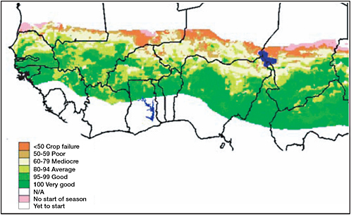
FIGURE 7.1 Map of the Water Requirement Satisfaction Index (WRSI) for the Sahelian countries of West Africa, 2002. Intervals of WRSI correspond to levels of crop performance and are derived from the Normalized Difference Vegetation Index observed by AVHRR and MODIS. Growing conditions for millet that year were especially poor in northern Senegal and southern Mauritania. SOURCE: USGS/NOAA/FEWS NET Sahel (FEWS NET, 2004).
Ecosystem changes due to climate change and human modification of the landscape and ocean are occurring in many parts of the world, notably in coastal zones where much of the world’s population lives, at high latitudes where climate change is lengthening the growing season, and in tropical forests, which are undergoing massive conversions for agricultural expansion and timber extraction. Even the vast, remote open ocean is experiencing large reductions in fish stocks because of harvesting. With accelerating changes in climate, land-use, and oceans over the coming decades, management of ecosystems to enhance and maintain provision of food, water, and other essential services for society is a critical challenge (Millennium Ecosystem Assessment, 2005).
The ability to manage ecosystems rests on a scientific understanding of their role in the Earth system. Models suggest that changes in terrestrial and marine ecosystems accelerate the rate of CO2 increase in the atmosphere and hence global warming. But models disagree about the response of primary productivity to the competing or synergistic effects of temperature and moisture (e.g., Cox et al., 2000; Fung et al., 2005; Friedlingstein et al., 2006). Moreover, the continuing ability of the ocean to take up CO2 is in question as a result of shifts in ocean circulation and temperature and in ecosystem response. Disturbances and modification of the land surface and the ocean, natural or anthropogenic, are likely to further modify ecosystems and hence the carbon-climate system beyond what the models project. Such changes may also increase the vulnerability of ecosystems to changing climate, moving ecosystems closer to thresholds beyond which there is no recovery and reducing their capacity to support life.
In summary, challenges posed by changing climate, land-use, air quality, invasive species, harmful algal blooms, and a host of other factors call for satellite capabilities that enhance our understanding of fundamental earth system processes and enable effective ecosystem management. The panel’s identified set of five high-priority satellite missions, in combination with continuation of the long-term record and other supporting observations from missions recommended by other panels, will enable scientific progress and improved management of ecosystems.
INFORMATION REQUIREMENTS FOR UNDERSTANDING AND MANAGING ECOSYSTEMS
The world’s ecosystems are subject to a variety of human-caused stresses, including changes in climate, changes in the chemistry of the atmosphere and ocean, changes in the frequency of severe storms, droughts and floods, and changes in land cover, land use, and ocean use. Those stresses can act singly or together to reduce the capacity of ecosystems to cycle water and nutrients or deliver food, water, or other ecosystem services. It is possible to halt and reverse ecosystem degradation (Millennium Ecosystem Assessment, 2005) and to enhance ecosystem services with carefully planned actions that have their foundations in science. Sustainable management of ecosystems requires information about their ability to carry out such functions as nutrient and water cycling (ecosystem function) and about the current state of and changes in the vertical and horizontal distribution of biomass within an ecosystem (ecosystem structure). Successful and adaptive management requires detecting trends early enough for intervention to be successful, efficient, and inexpensive. Late remediation can be extremely or even prohibitively expensive.
Citizens, decision makers, and other stakeholders need several types of information to support effective responses. Changes in ecosystems have to be observed and documented, if possible with early detection of emerging issues. To evaluate management alternatives, there is a need to project ecosystem conditions under likely future scenarios of management, subject to changing climate, land-use, and other anthropogenic stressors. That requires reliable information about the state of systems and credible models of dynamics. The last decade’s experience has shown that remote sensing data play a crucial role in developing, testing, and applying such decision-support models. Although many ecosystem issues develop slowly, there is also a need for remote sensing to provide decision support during and in the wake of episodic events, including abrupt events such as tropical storms and wildfires, and “slower” events, such as insect outbreaks, harmful algal blooms, and droughts.
These strategic needs are encapsulated in the overarching questions (listed in Box 7.1) that guided the panel’s consideration of which observational data will be required during the next decade.
BACKGROUND ON OBSERVATIONAL NEEDS AND REQUIREMENTS
To provide the necessary information and tools to policy makers and other stakeholders, an observational strategy is required that will address the strategic needs described in the previous section. On the basis of its assessment of observational needs for understanding and managing ecosystems and previous analyses of needs and goals by the scientific community (NRC, 1999, 2001), the panel identified three broad science themes and key questions for setting priorities among observational needs for the coming decade (Box 7.2).
Disruption of the Carbon, Water, and Nitrogen Cycles
Terrestrial and marine ecosystems play key roles in the global carbon cycle through photosynthesis, respiration, decomposition, and carbon releases and uptakes after such disturbances as fires. All those
|
BOX 7.1 STRATEGIC ROLE OF ECOSYSTEM SCIENCE AND OBSERVATIONS Observing Conditions and Trends in Ecosystems What are the current status of and trends in the distribution of ecosystems, their productivity, their degree of fragmentation by land-use, and other properties that affect the delivery of food, water, carbon storage, climate regulation, watershed protection, and other ecosystem services? Predicting Trajectories How will ecosystems and their ability to provide food, clean air and water, and healthy cities respond to future climate change, land-use and ocean-use change, and other anthropogenic stressors? Are there critical thresholds in the ability of ecosystems to cope with anthropogenic stressors? Managing Events What are the opportunities for early detection, continuing observation, and management of extreme events, such as hurricanes, droughts and wildfires, insect outbreaks, and flooding? What are the policy options for managing events that threaten human life and property? Can systems be managed to reduce their vulner-ability before such events occur? Can ecosystems be managed to store larger stocks of carbon? |
processes are altered by climate change and human uses of land and oceans. One of the major uncertainties in existing models is the future ability of oceans to take up CO2. The acidity of the ocean may be increasing more rapidly than previously thought (Orr et al., 2005), altering the ability of carbonaceous organisms to take up carbon, especially at high latitudes. Understanding feedbacks between dust production and transport, ocean iron, and carbon export also remains a challenge in Earth science. In the same vein, the functioning of terrestrial ecosystems at a high atmospheric CO2 and in a warmer atmosphere is unknown. The observations to test hypotheses about the spatial temporal pattern of contemporary oceanic and terrestrial sources and sinks for CO2 are currently not available.
The literature is growing on the interactions between the hydrological and nitrogen cycles and climate change (Melillo et al., 2002; Schlesinger and Andrews, 2000). Warming changes the water balance intrinsically, and even without changes in precipitation, it alters water availability, growing-season length, susceptibility to disturbances (including fires and insects), and thus a host of consequent ecosystem functions and services. Changes in the hydrological cycle are also profoundly disruptive to human societies through such extremes as floods and droughts. Space-based remote sensing has already proved critical for monitoring effects of droughts on vegetation productivity, fire occurrence, soil moisture, and surface temperature. During the 1990s, drought-related wildfires increased land-to-atmosphere fluxes of CO2 enough to affect the global growth rate substantially (VanderWerf et al., 2004).
Although less starkly evident than drought effects, changes in the nitrogen cycle resulting from air pollution and agriculture also have major consequences, both for the carbon cycle (which is partly regulated by nitrogen) and for air and water quality directly (Vitousek et al., 1997). There is growing evidence that excess nitrogen deposition in terrestrial systems from fertilizers and other sources can affect the carbon cycle and other ecosystem services through changes in crop yield and biodiversity (which is reduced by excess nitrogen).
In coastal and marine systems, continuing fertilization of the coastal ocean through nitrogen-rich terrestrial runoff will affect both its productivity and ecosystem structure. For example, the occurrence of harmful algal blooms appears to be increasing in U.S. coastal waters, and these blooms may be stimulated by increased nutrient availability (Figure 7.2). Conversion of estuaries and swamps to aquaculture is increasing throughout the world to provide more sources of protein. Reduction of large predators in marine food chains due to overfishing is cascading to lower trophic levels and hence carbon cycling.
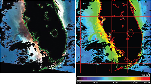
FIGURE 7.2 SeaWiFS captured these images of the Florida coast on September 17, 2001. In the left image, the colors red, green, and blue have been assigned to what the naked eye would see as green, blue-green, and blue. Clear blue offshore seawater appears blue, coastal water that is typically green appears red, and water with high levels of suspended sediment appears white. Water dominated by red tide appears dark gray. The right image is a false-color image showing milligrams of chlorophyll per cubic meter of seawater. SOURCE: E.Yohe, NASA Earth Science Enterprise, “Hunting dangerous algae from space,” NASA Distributed Active Archive Center (DAAC) Alliance, July 9, 2002. Available at http://earthobservatory.nasa.gov/Study/Redtide/.
Changing Use of Land and Ocean Resources
Conversion of lands for human use is essential for the human enterprise to grow food, build cities, and obtain other essential services. The increasing intensity and extent of human land-use are as global as is changing climate. Harvesting of fisheries from the ocean and water quality impacts from coastal development are also leading to massive alteration of ocean ecosystems. Changing land and ocean use may increase the vulnerability of human populations and ecosystems to changing climate, moving ecosystems closer to thresholds beyond which there is no recovery. Each land-use and ocean-use decision is unique, but there are regional and even global trends that have cumulative effects. The effects of changing land and ocean use vary widely—they include the formation of large sources and sinks of CO2, changes in hydrology and geomorphology, changes in landscape patterns that affect biodiversity, and a host of other effects (DeFries et al., 2004; Foley et al., 2005).
Remote sensing of land-cover and ocean-biomass change is crucial both for observing environmental change and as input in individual, local, national, and transnational decision making. Satellite
data—especially global, high-resolution satellite data—have proved their value and are now fundamental to studies of ecosystem change in academe, government, and the private sector. Improved sensors will increase the information content of ecosystem remote sensing from empirical measurements of type (more or less the current state of the art) to measurements of function, such as nutrient cycling and carbon sequestration (achievable with current exploratory technologies). If those measurements of function are coupled with sufficiently-precise and globally extensive measurements of atmospheric CO2, the interactions between water, carbon, and other element cycles will be better understood.
Changes in Disturbance Cycles
Drought, wildfire, severe weather (tornados, hurricanes, windstorms, and ice storms), and insect out-breaks are major disturbances of ecosystems and disrupt to ecosystem services. Altered disturbance regimes occur in response to intensification of land-use and climate change (Figure 7.3). For example, dramatic increases in the growth rate of CO2 in the atmosphere during 1997 were traced to wildfires in drought-affected areas of Indonesia (Page et al., 2002). The wildfires, although possible because of the drought, were initiated by human activity and occurred mainly in regions where soil moisture was reduced because of land-use change. Disturbance regimes affect the marine and coastal realms as well: coral reef, estuarine, and coastal ecosystems were reshaped for decades to come by the 2005 hurricanes and tsunami. Even the crude prognostic models of disturbance and mortality tested in the early 2000s suggest that climate change could have its largest effects through ecosystem dieback and vegetation change, even without the interactive effects of disturbance and land-use, as suggested in Indonesia. Observing disturbance cycles requires precise observations of ecosystems (i.e., effects of insects could be evident in hyperspectral data before many ground measurements would detect a problem), of disturbance (e.g., fire area and severity) and of local consequences (such as smoke plumes, sediment-loaded waters, and habitats for disease vectors) and global consequences (such as CO2 trends).
Summary of Data Needs
The challenges posed by changing climate, changing land use, changing air quality, invasive species, harmful algal blooms, and a host of other factors call for the capability to maintain and enhance a continuous observational record of ecosystem properties; observe episodic and extreme events, such as fire, pest, and disease outbreaks when and where they occur; and begin records of critical ecosystem functions through measurements of carbon cycling, soil water, and vegetation structure. To perform these functions, observation systems must provide data on an array of terrestrial, coastal, and open-ocean properties, as listed in Box 7.3.
PRIORITY SATELLITE DATA RECORDS AND MISSIONS
In this section, the panel identifies priority satellite missions to address the critical issues of climate-driven and resource-use-driven changes in ecosystems and the consequences for ecosystem functions. The suite includes missions for obtaining ongoing, long-term data records, as well as future missions with new technologies (Table 7.1). This suite is designed to detect and understand ecosystem change and to expand the information available for predicting, managing, and enhancing the provision of ecosystem services. The missions focus on quantitative observations of changing ecosystem processes, including ecosystem biogeochemistry, vegetation and landscape structure, water relations, and disturbance patterns, which are the key diagnostics for the wide array of key questions shown in Box 7.2. Although the missions are

FIGURE 7.3 Between 1993 and 1995, an outbreak of hantavirus pulmonary syndrome (HPS) claimed the lives of more than 45 people in the southwestern United States. The 1991–1992 El Niño had brought unusually high precipitation to the Four Corners region in 1992, which led to an increase in vegetation and a hypothesized increase in the rodent population that carried the hantavirus. Based on Landsat ETM+ satellite imagery, this map of the American Southwest shows the predicted risk of HPS in 1993. Red and yellow indicate high-risk areas, and dark blue indicates low-risk areas. SOURCE: Glass et al., 2000. Courtesy of the National Center for Infectious Diseases, Centers for Disease Control and Prevention.
designed to be comprehensive in the sense that they measure various quantities for detecting changes in ecosystem structure and dynamics, they focus on rigorous detection of effects related to the carbon cycle, the water cycle, the productivity and management of ecological communities, and habitat characteristics. The focus in this set of missions is on terrestrial and coastal marine regions where human effects and natural-resource extraction are concentrated, as well as the open ocean, where the effects are profound but less obvious to society.
The panel’s recommended space-based observations require a mix of techniques. Some quantities can be directly estimated from radiances above the atmosphere with physical techniques; examples are the hyperspectral measurement of leaf water content and phytoplankton fluorescence and the altimetric
|
BOX 7.3 ECOSYSTEM PROPERTIES FOR WHICH SATELLITE DATA ARE REQUIRED
|
measurement of canopy height with lidar. Others are derived from the statistics of direct measurements, such as estimates of landscape heterogeneity used in conservation biology and ecosystem management and the inference of surface sources and sinks of CO2 from space-based measurements of column-integrated atmospheric CO2. A third category includes quantities that result from using direct observations as inputs in physical, biological, or statistical models; an example is the estimation of carbon uptake and release through photosynthesis and respiration in marine or terrestrial systems, which are inferred from space-based estimates of photosynthetic light absorption. A final category includes quantities estimated from time series of measurements, which by their rate of change define some other process (for example, the integral of photosynthesis over time can define biological productivity).
Operational Satellite Records to Enhance and Maintain the Long-Term Record on Ecosystem Dynamics
The currently available long-term record of ecosystem dynamics from a variety of sensors is critical for understanding and managing ecosystems in the coming decades. The panel places high priority on maintaining and enhancing this record. The role of multiyear time series in understanding ecological dynamics has long been recognized. From classic examples like the scientific exploitation of the Canadian Lynx-Hare data set through the establishment of the Long Term Ecological Research (LTER) network and newer classic papers that used decadal eddy covariance record, long time series have shaped the field. Understanding of global-scale processes has been substantially advanced through long time series, including the ice-core records, the Keeling record of atmospheric CO2, the CZCS-SeaWiFS-MODIS records of ocean color, and the AVHRR and Landsat records of photosynthesis and land-cover change. Long-term records of photosynthetic activity have enabled forecasts of impending food shortages, pest outbreaks, and other key ecological linkages with human health. To meet the challenges for understanding and managing ecosystems in the coming decade, the maintenance and extension of long-term ecosystem records are paramount. Here, the panel briefly reviews critical applications, problems, requirements, and opportunities.
There are three fundamental long-term satellite records of ecosystem dynamics, and each addresses a separate issue. First is ocean color, which began with the Coastal Zone Color Scanner and continues with
TABLE 7.1 Land-Use Change and Ecosystem Dynamics Panel Priority New Missions
|
Summary of Mission Focus |
Variables |
Type of Sensor |
Coverage |
Spatial Resolution |
Frequency |
Synergies with Other Panels |
Related Planned or Integrated Missions |
|
Ecosystem function: climate and land-use impacts on terrestrial and coastal ecosystems |
Terrestrial: Distribution and changes in key species and functional groups of organisms, disturbance patterns, vegetation stress,vegetation nutrient status, primary productivity, vegetation cover Coastal: coral-reef health and extent |
Hyperspectral |
Global, pointable |
50–75 m |
30 day, pointable to daily |
Climate Health Solid Earth |
HyspIRI |
|
Ecosystem structure and biomass |
Standing biomass, vegetation height and canopy structure, habitat structure |
Lidar and InSAR |
Global |
50–150m |
Monthly |
Climate Health Solid Earth |
DESDynl ICESat-II |
|
Carbon budget |
CO2 mixing ratio, CO concentrations |
Active lidar |
Global |
100m strips |
Diurnal—assimilated every 24 hours |
Climate Weather |
ASCENDS |
|
Coastal ecosystems dynamics |
Photosynthesis, sediment fluxes, phytoplankton community structure, algal blooms |
Hyperspectral |
Western Hemisphere |
250 m |
Several times/day |
Health Solid Earth Weather |
GEO-CAPE GACM |
|
Global ocean productivity |
Photosynthesis, colored dissolved organic matter, chlorophyll |
Hyperspectral |
Global |
1 km |
2-day global coverage |
Climate (with additional UV/visible bands on polarimeter) |
ACE |
MODIS. These records link the considerable physical variability of the ocean to its intrinsic biological variability and are essential for understanding ocean processes and evaluating models. This measurement has been continually improved since the launch of CZCS in 1978. Further improvements are possible on the basis of developments in scientific understanding, technology development, and atmospheric correction (see the panel’s mission recommendation below to enhance capabilities to monitor productivity in the open ocean). The second long-term record is the terrestrial greenness record that began with the insightful
but unplanned scientific exploitation of the AVHRR sensor and continues with MODIS and other satellite instruments. The record also has seen increasingly sophisticated applications, from a crude measurement providing an index of photosynthetic changes on seasonal and year-to-year time scales to retrieval of specific canopy properties used to estimate magnitudes and timing of critical ecosystem fluxes. The third long-term record is the record of land-cover change, derived mainly from Landsat, which has proved invaluable in quantifying deforestation and carbon emissions, urbanization, habitat fragmentation, and habitat for disease vectors and in managing natural resources and development activities. These three records have been used to address a wide array of scientific and practical problems and they continue to gain in value.
These records detect changes that occur cumulatively over decades, such as deforestation, and they gain in value with their increasing length. Several lessons can be drawn regarding long-term records. First, the records are—to a first approximation—independent of the sensor. All the records have been constructed with multiple sensors. With care, accurate time series can be constructed with multiple sensors, thus allowing the use of improved technology and gaining more detail. Second, continuing the legacy of records requires care and effort. Records can be continued from one sensor family into another (AVHRR to MODIS and beyond to VIIRS on NPP and NPOESS), but issues of bias, calibration, and interference must be solved. For example, even within the AVHRR record, person-years of effort over a decade or more were required to construct a record correcting for instrument-to-instrument differences, shifts in overpass time within a mission, and atmospheric interferences. Even today, those corrections continue to be refined for some geophysical quantities.
The issue of deriving consistent, long-term climate records from operational satellite records has been the focus of several National Research Council studies over the last decade, (e.g., NRC, 2004). The issues and recommendations from those studies remain relevant today, and they have taken on new urgency with the planned launch of NPOESS in the next decade. Moreover, new issues have arisen, especially as sensor performance and operating scenarios for NPOESS have become clearer. In particular, the fundamental global measurement of ocean color from VIIRS will not meet science requirements, given the current plans, creating the need for additional observational capabilities. Assuming that VIIRS will meet the threshold environmental data record (EDR) requirements (and this is by no means ensured), the NPOESS platforms will not collect regular lunar observations to characterize the performance of VIIRS. The need for such lunar observations on a monthly basis has been unequivocally demonstrated through analysis of the Sea-WiFS record. Even that sensor showed significant and unpredictable changes in response. If there had not been regular lunar observations, a consistent, multiyear time series could never have been developed. The Integrated Program Office for NPOESS has ruled out similar lunar observations for their platforms; thus, new approaches must be found for a global-scale, multiyear, consistent time series of ocean color (see the section below titled “Global Ocean Productivity”).
The panel recommends the following concerning long time-series observations:
-
Long time series of critical environmental variables need to be maintained, with the highest priority attached to records related to land and ocean primary productivity (ocean color and terrestrial greenness) and high-resolution land cover. These records should be continued whenever possible with improved technology and improved scientific approaches.
-
Care should be taken when continuing and enhancing long-term (legacy) environmental records to ensure back-compatibility. That is, when new sensors are flown that use cheaper or safer technologies or that improve on the geophysical products, the required steps should be taken to allow the legacy and new approaches to be cross-calibrated so that the time series can continue without the injection of unknown error, noise, and bias.
Ecosystem Function
Mission Summary—Ecosystem Function
|
Variables: |
Distribution and changes in key species and functional groups of organisms; disturbance patterns; vegetation stress; vegetation nutrient status; primary productivity; vegetation cover; coral-reef health and extent |
|
Sensor(s): |
Hyperspectral |
|
Orbit/coverage: |
LEO/global-pointable |
|
Panel synergies: |
Climate, Health, Solid Earth |
|
New science: |
Land ecosystem chemistry, diversity, leaf water stress; coral reef health and extent |
|
Applications: |
Ecosystem interactions with changing climate, agriculture, invasive species, disturbance, management, urbanization |
Ecosystem function, the first mission concept listed in Table 7.1, is aimed at detecting a suite of functional responses of ecosystems to direct human and climate impacts and providing detailed information for improved management of ecosystems. This mission builds on legacy remote sensing measurements of chlorophyll and visible reflectance and will use direct and inferential techniques for observing the spatial pattern of additional key functional properties of ecosystems. The properties targeted reveal ecosystem responses critical for understanding the effects of climate, land use, and resource use. Key properties are listed in Box 7.3 and include indexes of ecosystem composition (distribution of and changes in key species or functional groups of organisms and disturbance patterns) and ecosystem health and dynamics (leaf water stress and energy-water-carbon-nutrient fluxes). The mission focuses on terrestrial ecosystems but would also address coral-reef health and extent.
Climate and land and resource use affect ecosystems by changing fluxes of matter and energy and in the longer term by changing the distribution of species and ecosystem types. For example, drought initially affects the magnitude and timing of water and carbon fluxes, causing plant water stress, and changes in leaf area. In the longer term, water-stress-induced mortality and wildfires can cause ecosystem change, causing changes in species dominance toward more stress-tolerant or weedy species, or even ecosystem structural change, with grasslands or shrublands replacing forests. Changes in chemical climate (ozone and acidic deposition) cause initial changes in the chemistry of leaves and then eventual ecosystem changes as more tolerant species replace native species. A terrestrial-ecosystem mission must detect the early warning signs of change through remote sensing of properties related to photosynthesis and other physiological processes.
The most promising technology for quantifying changes in ecosystem relies on imaging spectroscopy (400–2500 nm) of the global land surface. The hyperspectral objectives are canopy water content, vegetation stress and nutrient content, primary productivity, two-dimensional ecosystem heterogeneity, fire fuel load and fuel moisture content, and disturbance occurrence, type, and intensity. These measurements are made by using a spectroscopic analysis approach afforded by observation of the full optical spectrum. The Hyperion sensor has shown that space-borne imaging spectrometer observations can advance ecosystem science by providing observations of canopy water, pigments, nutrients, CO2 uptake efficiency, and species diversity (Asner et al., 2004). Hyperion data have been provisionally used in a mainstream ecosystem dynamics model to simulate carbon sources and sinks in the northeast United States and have shown substantial increases in accuracy over previous methods. Despite these early successes, Hyperion demonstrated that shortfalls in sensor uniformity, stability, and signal-to-noise performance limited its value in higher levels of ecosystem analysis. The accuracy, precision and autonomy of the measurement suffers when instrument performance is lower, as was the case with EO-1 Hyperion (Asner and Heidebrecht, 2003), or when the measurement is limited to multispectral sampling of the important wavelength regions.
The temporal and spatial resolutions required for ecosystem-change studies depend on the scales of ecosystem variability. Ecosystems vary over multiple scales, but detection of disturbance and landscape
patterns, especially in intensively managed areas, implies relatively high spatial resolution (less than 1 km). Studies of regional and global biogeochemistry have effectively used MODIS data at 250-, 500-, and 1-km resolution. Studies of community change and habitat heterogeneity require slightly higher resolution, and discussions with investigators studying biodiversity and invasive species indicate a need for data at a resolution of 50–150 m. The target resolution of a global ecosystem-change mission should be higher than that of MODIS (less than 250 m), but a determination of the exact resolution should balance the need for high temporal resolution and global coverage against spatial resolution, leaving the extremely high spatial resolution (which is required most often in specific locations rather than with global coverage) mission to the private sector and operational satellites. Data from towers measuring gas fluxes show that the bulk of interannual variability in carbon uptake can be associated with changes in the timing of the growing season. Detecting climate-ecosystem interactions requires precise detection of the start and end of the growing season, as well as detection of stress episodes. The longest revisit time acceptable is a month or so; this depends on cloud cover and other interferences and may not always be achieved. To combine repeat coverage with the ability to image events that could include large disturbances (such as wildfires) or abrupt seasonal transitions in critical areas, pointability is needed to occasionally allow more frequent revisits to critical areas. The science team would need to allocate observing time dynamically between the background program and targeted acquisitions.
Ecosystem Structure and Biomass
Mission Summary—Ecosystem Structure and Biomass
|
Variables: |
Standing biomass; vegetation height and canopy structure; habitat structure |
|
Sensor(s): |
Lidar and InSAR |
|
Orbit/coverage: |
LEO/global |
|
Panel synergies: |
Climate, Health, Solid Earth |
|
New science: |
Global biomass distribution, canopy structure, ecosystem extent, disturbance, recovery |
|
Applications: |
Ecosystem carbon and interactions with climate, human activity, disturbance (including deforestation, invasive species, wildfires); carbon management; conservation and biodiversity |
Recent breakthrough technologies and retrieval algorithms for radar and lidar sensors offer the most promising techniques for a globally consistent and spatially resolved measurement of forest three-dimensional structure and aboveground woody biomass from space. The global stock of aboveground biomass and its associated below-ground biomass component stores a large pool of terrestrial carbon. The magnitude of this pool, its horizontal and vertical structure, and its changes as a result of natural and human-induced disturbances (such as deforestation and fires) and the recovery processes are critical for quantifying ecosystem change. Two technologies can provide this information.
Imaging radar sweeps the landscape with radio waves penetrating into the forest canopy and scattering from large woody components (stems and branches) that constitute the bulk of aboveground woody biomass and the carbon pool. Synthetic-aperture radar (SAR) and interferometric synthetic-aperture radar (InSAR) measurements are particularly suitable for estimating three-dimensional structure of forest ecosystems. InSAR can measure forest height with accuracy to within meters, and the combination of polarimetry and interferometry can further improve estimation of three-dimensional forest structure. The sensitivity of back-
scatter measurements at different wave polarizations to woody components and their density makes low-frequency (P-band or L-band) radar sensors suitable for direct measurements of live aboveground woody biomass (carbon stock) and structural attributes, such as volume and basal area. Current radar technology allows measurements from space with high spatial resolution (100–250 m) and day and night observational capability regardless of atmospheric conditions and cloud cover. Such a system could access information over forests globally; gauge the magnitude of forest biomass in boreal, temperate, and tropical regions; monitor and identify forest disturbance (fire, logging, and deforestation); and characterize postdisturbance recovery. L-Band InSAR, ideally with multiple polarizations, seems most suitable for measurements of ecosystem structure, particularly because such a mission would be synergistic with science goals of the solid-Earth, hydrology, oceanography, and cryosphere communities (see Chapter 8).
Lidar systems can use multibeam laser altimeters, sampling the landscape and measuring with great precision the distance between the canopy top and bottom elevation and the vertical distribution of intercepted surfaces. The measurements yield the most direct estimates of the height and vertical structure of forests. A lidar design with multiple beams operating around 1,064 nm can provide about 25-m spatial resolution and 1-m vertical accuracy, systematically sampling Earth’s surface, rather than imaging the entire surface, but providing a more direct retrieval than InSAR. The ideal ecosystem structure and biomass mission would combine the two approaches, taking advantage of the precision and directness of lidar to calibrate and validate InSAR, especially in ecosystem types for which field campaigns have not been undertaken. The two sensors could fly on different platforms, but the need for coincident observations separated by not more than a few weeks is critical for using the lidar measurements to calibrate the radar measurements.
Several responses to the committee’s request for information (RFI; see Appendixes D and E) call for a different strategy, and suggest a more regional focused approach, using a geostationary platform to achieve diurnal coverage. That is an interesting approach, pushing the data toward the “weather” time scales. Only a few ecosystem variables change fast enough to be detectable on subdaily time scales—mainly those related to energy balance or planktonic dynamics—but the diurnal sampling would also allow detection of day-to-day changes and precise determination of growing-season length. The panel adopted this approach for a coastal ecosystem-dynamics mission (see below) but focused on global low Earth orbit (LEO) coverage as the primary terrestrial approach. Although the highest priority is given to a global mission, there should be continued study of the opportunities for ecosystem science from a geostationary experiment and identification of the key variables and science return from high-frequency sampling in time.
The panel also considered suggestions using multiangle remote sensing, which can retrieve some ecosystem-structure properties. That approach is promising and could take advantage of instruments whose primary targets are atmospheric properties, but it is more limited in the array of ecosystems that could be sampled (these methods probably will not work well at high biomass levels) and in cloudy regions (such as Amazonia) (Bergen et al., 2006). Those limitations precluded a recommendation of multiangle instruments as a primary sensor for ecosystem structure, but they would be a useful complement and also provide data on variables (surface BRDF and albedo) that have wide application. Terrestrial applications of a multiangle sensor designed primarily for cloud and aerosol studies would be of great interest and are supported by the ecosystems panel.
Carbon Budget
Mission Summary—Carbon Budget
|
Variables: |
CO2 mixing ratio, CO concentrations |
|
Sensor(s): |
Lidar |
|
Orbit/coverage: |
LEO/global |
|
Panel synergies: |
Climate, Weather |
|
New science: |
Active measurements of CO2 mixing ratio at high spatial and temporal resolution during night and cloudy conditions, CO as a tracer |
|
Applications: |
High-resolution global distribution of carbon sources and sinks |
About half the anthropogenic emissions do not stay in the atmosphere but are sequestered in the oceans and on land. However, much uncertainty exists as to the mechanisms responsible for these sinks. A change in the capacity of these sinks will have important consequences for the future atmospheric composition and its associated climate forcing. Much of what is known today about how the atmosphere is changing and the rough geographic distributions of the carbon sinks comes from a sparse in situ network of about 100 surface atmospheric sampling stations in remote island or coastal locations. Their observations are designed to capture large-scale changes in background CO2 and are too sparse in time and space to reveal adequately the sink processes, especially those on land, and the sensitivity of the processes to climate perturbations. That lack of knowledge has a great effect on societal welfare. As nations seek to develop strategies to manage their carbon emissions and sequestration, the ability to identify and quantify the present-day regional carbon sources and sinks and to understand their climate sensitivity is central to prediction and thereby to informed policy decisions.
Global measurements of column-integrated atmospheric CO2 with sufficient precision and sample density for accurately recovering surface fluxes are feasible only from satellite platforms. The first step in inferring terrestrial ecosystem processes from atmospheric data is to separate photosynthesis and respiration; for this, diurnal sampling is required to observe nighttime concentrations resulting from respiration. It is important to have measurements at all latitudes in all seasons, especially on high-latitude land, where temperatures are increasing and growing seasons are lengthening most rapidly, and over the unobserved Southern Ocean, whose strength as a sink for anthropogenic CO2 is unresolved. It is also essential to separate physiological fluxes from biomass burning and fossil-fuel combustion, and this requires quasisimultaneous measurement of an additional tracer, ideally CO. Socioeconomic statistics on fossil-fuel consumption are useful as a first estimate but afford a less objective approach that is difficult to verify.
The needs for measurements of atmospheric CO2 via an active (laser) sounder are specifically stated in national and international science documents. The carbon budget mission is to characterize CO2 sources and sinks on a sub-regional spatial scale in near-real time. Achieving that will require advances in measurement approaches and technology. The current state of the art of space-based remote sensing of atmospheric CO2 is the Orbiting Carbon Observatory (OCO), scheduled for launch in 2008. OCO is a NASA Earth System Science Pathfinder (ESSP) mission for measuring total-column CO2 and O2 by detecting spectral absorption in reflected sunlight. Although the OCO will yield a vastly increased volume of data for characterizing the distribution of atmospheric CO2 and inferring surface sources and sinks, unavoidable physical limitations are imposed by the passive-measurement approach, including daytime-and high-Sun-only sampling, interference by cloud and aerosol scattering, and limited signal variability in the CO2 column. A laser sounder mission, consisting of simultaneous laser remote sensing of CO2 and O2 (needed to correct for atmospheric pressure, topography, and target-height effects) would provide new active measurement capabilities to overcome the most serious of those limitations. Such a mission should
provide full seasonal sampling at high latitudes, day-and-night sampling, and some ability to partially resolve (or weight) the altitude distribution1 of CO2.
Lidar CO2 and O2 measurement should be complemented by a CO sensor, either as part of the CO2 satellite or by coordination with a “chemical-weather” mission. CO is a major pollutant with a lifetime of 1–3 months and is important for atmospheric-chemistry and air-pollution studies. Although CO is a valuable tracer that allows identification of biomass burning and industrial plumes for carbon science, CO2, which is chemically inert in the atmosphere, can be a valuable tracer of transport for chemists. The two measurements are highly synergistic and should be coordinated for time and space sampling, with the minimal requirement that the two experiments be launched close together in time to sample the same time period. Technology options for CO are discussed in Chapter 10. Ideally, to close the carbon budget, methane should also be addressed, but the required technology is not now obvious. If appropriate and cost-effective methane technology becomes available, methane capability should be added.
Improved measurements of CO2 absorption line parameters are being conducted for the OCO and are not expected to constitute an important error source for the proposed mission. CO2 lines are available in the 1.57-, 1.60-, and 2.06-µm bands that minimize the effects of temperature errors. The R24 line centered at 1.5711 µg is a good candidate because of its insensitivity to temperature errors, relative freedom from interfering water-vapor bands, good weighting functions for column measurements, and high technology readiness of the lasers in this wavelength region. Temperature errors can be reduced to less than 1 K with the new sounding instruments and retrieval models under development for NPOESS. Pressure errors are addressed with a combination of simultaneous O2 measurements or possibly with surface altimetry measurements from a pulsed lidar with advanced meteorological analysis for surface pressure. On-board O2 measurements can be based on laser absorption spectrometer measurements on an O2 absorption line in the 0.76- or 1.27-µm band.
Long-term accurate measurements of atmospheric CO2 with global “wall-to-wall” coverage will greatly enhance understanding of the distribution of sources and sinks for CO2 in time and space. The measurements will allow a fundamental shift in the understanding of these processes, which are currently poorly understood because of a paucity of data. This observational objective is within reach in the next half-decade and should be a cornerstone in an Integrated Carbon Observing System (ICOS). The ICOS should be built on high-precision long-term ground-based CO2 observation networks and new active satellite observations, which will fill in the gaps of the ground-based network in regions virtually impossible to sample.
The ground-based CO2 network requires a global distributed infrastructure capable of sustained atmospheric measurements of CO2 and related tracers at the highest accuracy with minimal risks of hiatus in data during several decades in the future. Components of the future infrastructure already exist in the United States, with the NOAA-CMDL (Climate Monitoring and Diagnostics Laboratory) global air-sampling program, but in Europe they need to be integrated into a more harmonized observing system. Developing common methods, standards, data-management systems, protocols, and instrumentation will increase the cost efficiency of the global in situ observations by avoiding duplication and by facilitating data sharing.
The coupling of this high-precision, high-volume data stream combining in situ and satellite observations with atmospheric inversion, data assimilation, and coupled atmospheric, terrestrial, and ocean carbon modeling will permit quantification of the sources and sinks at unprecedented space and time resolution. The final scientific outcomes will be greatly advanced understanding of the global carbon cycle and the scientific foundation essential for making reasoned projections of atmospheric concentrations of CO2. Even more important, it will put into place an important brick in the infrastructure that will be needed for the next century to address changes in the environment of our planet.
|
1 |
It is not necessary to provide atmospheric profiles; rather, the primary information is in the horizontal gradients of column-integrated CO2. However, most of the gradient is in the lower portion of the atmosphere, and so attaining sufficiently precise measurement of the gradients will require weighting the measurement to lower portions of the atmosphere. |
Coastal Ecosystem Dynamics
Mission Summary—Coastal Ecosystem Dynamics
|
Variables: |
Photosynthesis, sediment fluxes, phytoplankton community structure, algal blooms |
|
Sensor(s): |
Hyperspectral |
|
Orbit/coverage: |
GEO/coastal zones |
|
Panel synergies: |
Health, Solid Earth, Weather |
|
New science: |
Diurnal cycles of productivity and marine chemistry; coupling of land and open ocean |
|
Applications: |
Harmful algal blooms, fisheries, ecosystem-based management, aquaculture, impacts of extreme events, productivity |
A primary objective for observing coastal ocean regions is to determine the impact of climate change and anthropogenic activity on primary productivity and ecosystem variability. The high productivity of the coastal ocean supports complex food webs, and a disproportionate amount of the world’s seafood is harvested from the coastal ocean. Harmful algal blooms in these regions introduce toxins with major human and ecosystem health consequences. These ecosystems are under enormous pressure from human activities, both from harvesting and from materials entering the coastal ocean from the land and the atmosphere. Climate change will also have important effects through changes in the hydrologic cycle (for example, peak runoff of the Columbia River is expected to be an average of 6 weeks earlier in the year as a result of Earth’s warming), wind forcing (for example, shifts in the timing and intensity of upwelling-favorable winds), and agricultural practices (for example, fertilizer use and irrigation).
Many changes in the coastal ocean ecosystem are beginning to be detected. Persistent hypoxic events or regions associated with riverine discharge of nutrients in the Gulf of Mexico and increasing frequency of harmful algal blooms in the coastal waters of the United States with extensive closures of coastal fisheries are only two of the issues confronting the coastal ocean. The structure of coastal marine ecosystems is at the intersection of global-scale changes in the natural environment and intense human activity. The coastal ocean is an important and poorly observed component of the global ocean carbon cycle. About 25 to 50 percent of global marine photosynthesis occurs in the coastal ocean although the coastal zone makes us only 10 percent of the global ocean. The carbon flux from land to ocean can be significant: riverine flux to the coastal ocean of the United States is 10 to 30 percent of the atmosphere-land carbon flux. Carbon fixed through photosynthesis in the coastal ocean is strongly influenced by complex physical and biological controls on nutrient supply and light availability. The air-sea exchange of CO2 depends on both physical transport processes in the atmosphere and ocean and biological uptake. The interface between saltwater and freshwater plays a unique and important role in mediating the land-ocean interface and global biogeochemistry. Carbon exchange between the continental margin and the deep sea (including land-to-ocean transport of carbon) is poorly understood because it is often small and, when larger, takes place episodically.
Recent work highlights the progress in estimating ocean primary productivity from satellite-derived measurements of chlorophyll, phytoplankton growth rates, natural and harmful algal blooms, and carbon uptake (Behrenfeld et al., 2005). Remote sensing of the coastal ocean poses a unique challenge owing to the small-scale spatial variability and increased concentrations of dissolved organic carbon (DOC), detritus, and chlorophyll, which are difficult to distinguish because they all absorb light intensely in the blue end of the visible spectrum. However, DOC can be separated by using observations in the UV. The absorption of colored dissolved organic matter (CDOM) increases exponentially into the UV; absorption by particles contributes a smaller and smaller proportion of total absorption from blue to UV wavelengths.
Ocean data products include measurements of chlorophyll, particulate and dissolved organic matter, turbidity, and phytoplankton growth rates. Primary productivity, particulate inorganic carbon (organic sediment), and land-ocean carbon fluxes are other target quantities detectable or inferrable from ocean spectral measurements derived from the basic spectral signals. The instrument and mission characteristics of a
coastal experiment are to a first approximation consistent with those of a land-oriented mission, but issues of spectral resolution, signal-to-noise ratio, gain, and atmospheric correction would have to be studied.
Atmospheric correction, accurate instrument characterization and calibration, high signal-to-noise ratio, and spectral range are all issues for a marine or coastal spectrometer. In coastal waters, the presence of absorbing aerosols and high in-water particle loads, which can invalidate the black-ocean assumption for short near-IR bands used in current atmospheric correction algorithms, complicate standard atmospheric corrections applied for current ocean-color satellite observations. Negative water-leaving radiances for the 412-nm band (and at times for the 443-nm band) on SeaWiFS and MODIS occur frequently in coastal waters because standard atmospheric corrections are not adequate for coastal waters, especially for nearshore waters and estuaries. However, intensive work in recent years with air-borne spectrometers has demonstrated the utility of this approach in coastal waters with complex optical signals. New methods for atmospheric correction have been developed, and they are proving to work in a variety of conditions.
Because of the complexity of both in-water and atmospheric optical properties in the coastal ocean and the requirement to estimate more of the constituents of the water-leaving radiance signal, a far more capable sensor than the SeaWiFS/MODIS class is needed. Recent work with both in situ and airborne sensors has demonstrated that hyperspectral sensors can be used successfully in coastal environments and that detailed information on spectral shape and absorption at specific wavelengths can be used to extract quantitative information on the constituents of the upper ocean. In fact, those measurements have shown that the traditional multiband, absorption-based algorithms can fail in optically complex waters.
Because many of the compounds of interest have strong absorption in the UV portion of the spectrum, it is essential that observations be made down to 350 nm. It will be necessary to extend the spectrum to about 1,050 nm to observe the atmosphere against a “dark” background. Making observations in the UV portion will be challenging, given the small signal. Moreover, separating the effects of atmospheric aerosol (particularly absorbing aerosols) against an optically complex ocean that has variable levels of reflectance is also difficult. However, there has been considerable research in the last decade, and these challenges are being overcome.
The ecological and biogeochemical processes in the coastal ocean occur on small time and space scales, and a substantial portion of the variability is forced by solar and tidal cycles. For example, measurements of the photo-oxidation of dissolved organic materials will be needed to resolve the diel variations in concentration and to estimate the strength of this process. Many phytoplankton species that form harmful algal blooms show strong vertical migration on a diel basis, so multiple “looks” per day will also be necessary to resolve these processes. In summary, there is a close coupling between small spatial scales and short temporal scales in the coastal ocean. Current speeds tend to be higher near-shore because wind energy is distributed over a shallower water column than in the deeper, open ocean. Strong salinity discontinuities result in strong, transient frontal boundaries. Thus, the science requirements drive the mission to a geosynchronous orbit to provide multiple viewing opportunities every day. Such a mission could also take advantage of cloud-free periods and “stare” at specific regions to increase the signal-to-noise ratio of the measurement. These capabilities are not available for polar-orbiting platforms.
Given these issues, the panel strongly recommends a geosynchronous mission focusing on the Western Hemisphere rather than a complete global mission. Such a mission would study a broad array of conditions, including upwelling systems associated with eastern boundary currents off North America and South America, areas with substantial river inflow (such as the Amazon, Mississippi, and Columbia), effects on urban areas in the coastal zone, and relatively pristine areas. Such a mission would focus on specific ecosystem and biogeochemistry questions in the coastal zone rather than simply mapping global-scale processes. It would have the temporal and spatial resolution necessary to resolve critical processes in the coastal ocean, and it would have the sensor capabilities (signal-to-noise ratio, spectral resolution, and so on) needed to de-convolve the complex atmospheric and ocean optical signals.
Global Ocean Productivity
Mission Summary—Global Ocean Productivity
|
Variables: |
Photosynthesis, colored dissolved organic matter, chlorophyll |
|
Sensor(s): |
Hyperspectral |
|
Orbit/coverage: |
LEO/global |
|
Panel synergies: |
Climate |
|
New science: |
New ecosystem products based on spectral matching techniques, including phytoplankton pigments and colored dissolved organic matter |
|
Applications: |
Ecosystem-based management, productivity, regulation by different ocean nutrients (such as nitrate and iron) |
Beginning with CZCS, global ocean-color missions have dramatically increased understanding of ocean ecosystems and their relationship to climate and biogeochemical systems. Ranging from seasonal observations of the spring bloom in the North Atlantic to the discovery of mesoscale fronts in the Equatorial Pacific to long-term trends in ocean primary productivity, the succession of ocean-color missions (CZCS to SeaWiFS to MODIS) has identified new processes based on continuous evolution in the technical capabilities of the sensors. As with the coastal-ecosystem mission, the global ocean-productivity mission will focus on the quantification of upper-ocean biomass and primary productivity and on important aspects of ecosystem structure as they are related to changes in climate and their effects on biogeochemical cycling (Behrenfeld et al., 2005).
Although the productivity per unit area of the open ocean is lower than that in the coastal zones, the vast extent of the open ocean makes it an important sink of atmospheric carbon. The uptake of atmospheric CO2 varies widely on a regional and seasonal basis, but the long-term export of carbon from the upper ocean to its sequestration in sediments on the abyssal ocean is thought to be relatively constant. However, persistent shifts in ocean circulation and ecosystem structure may alter this balanced system. For example, the Hawaii ocean time-series station north of the island of Oahu has documented large-scale, multiyear shifts in the phytoplankton community from one that is regulated by nitrate availability to one that is regulated by phosphate. Those shifts have an important effect on export rates to the deep ocean. Recent research by Behrenfeld et al. (2006) has demonstrated that differential regulation by iron and nitrate can be detected through remote sensing, and consistent, long time series of these measurements will greatly enhance the development of prognostic circulation and ecosystem models.
As with observing systems for coastal ecosystems, the next generation of global ocean-color sensors will need far greater spectral coverage in terms of both resolution and spectral extent. The need to detect small but important changes in the bio-optical properties of the upper ocean lead to more stringent sensor performance requirements in the face of complex atmospheric and ocean optical processes. Siegel et al. (2005) note that traditional wavelength ratio algorithms assume that the optically active components of the ocean vary in a consistent manner. The assumption is not correct, however, and they propose the use of a “spectral-matching” method. The new approach requires far more than the 7–10 bands of SeaWiFS, MODIS, and VIIRS, and it results in significantly different estimates of global primary productivity. If observations are extended into the 360- to 400-nm range, the spectral-matching approach produces a more robust separation of CDOM from other constituents of interest. Expanded spectral capabilities will also enable the differentiation of different phytoplankton pigment groups. Because many of these pigment-based groups have different roles in ecosystem processes and biogeochemical processes, there new measurements will support the development of more sophisticated models.
With improved measurements of standing stocks (chlorophyll, pigments, and CDOM), an enhanced ocean-color sensor will enable improved rate measurements. Behrenfeld et al. (2005) have shown that spectral matching techniques can be used to derive simultaneously absorption and backscattering proper-
ties, which can be used to model both phytoplankton carbon (not just chlorophyll biomass) and growth rates. Bands to measure chlorophyll fluorescence (similar to those on MODIS) can be used to estimate the light-adaptive state of phytoplankton, and Behrenfeld et al. (2006) have shown that such observations can be used to detect iron-stressed phytoplankton.
Improved atmospheric correction is essential for all these observables, particularly in regard to aerosols, which have temporal and spatial scales of variability that are similar to ocean properties. Bands should be placed near 1,400 nm to account for turbid waters that are “bright” in the traditional atmospheric correction wavelengths around 865 nm. More-sophisticated techniques are necessary to account for absorbing aerosols. Although bands in the UV wavelengths will help to account for the absorbing aerosols, a polarimeter (as proposed by the Panel on Climate Variability and Change) will provide knowledge of the height and total column thickness of these aerosols. This will build the basis of the next generation of atmospheric correction models.
Taken together, those requirements lead to the panel’s strong recommendation for a global ocean-productivity mission that would be accommodated as part of the aerosol mission recommended by the climate panel. The mission would be a polar-orbiting platform providing global coverage every 2 days, which is essential to provide the necessary temporal coverage, given typical patterns of cloudiness. The sensor would have at least 20 selectable bands between 350 and 1,400 nm, with 1-km resolution at the nadir. The sensor would be able to tilt fore and aft to reduce the impacts of Sun glint with signal-to-noise ratio of about 1,500:1 in the UV range, decreasing to 500:1 in the near-IR. The sensor would need to have low polarization, and well-characterized (and low) cross-talk, stray light, and out-of-band spectral response. The mission would provide the necessary next-generation global ocean-color measurements to advance understanding of the interplay between climate, biogeochemical cycling, and ecosystem structure in the upper ocean. With projected changes in atmospheric forcing and increasing acidity, it is essential to develop more sophisticated prognostic models in order so that the future role of ocean uptake in carbon cycling and ecosystem services can be understood.
Related Observational Needs for Climate and Other Variables
To understand the causes of observed ecological changes and to assess the response of ecological processes to climate changes, a suite of climate and context variables must be measured. They include many standard climate variables proposed for measurement as part of the weather and climate requirements or available through assimilation and analysis systems. The list for all ecosystems includes surface temperature, precipitation, and incoming radiation, especially in the photosynthetic wavelengths. For terrestrial systems, soil moisture is the critical variable linking climate and ecosystem response. For marine systems, sea-surface temperature, ocean vector winds, and topography (for currents) are required because of the tight coupling of physical dynamics and marine ecosystems. Of that list, several—soil moisture, ocean topography, and ocean vector winds, for which the ecological requirements differ from or are more stringent than the corresponding physical (hydrological or atmospherically oriented) requirements—are discussed below.
The important hydrological control over terrestrial ecosystems is soil moisture, not precipitation, and current models are not good enough to infer soil moisture accurately from precipitation and temperature. Drought in the atmosphere becomes biological drought when soil moisture is depleted, triggering a range of ecological responses—from stress and reduced productivity to plant mortality, increased wildfire and insect damage, and eventual replacement of ecosystem types. Moreover, changes in soil moisture affect the amount of dust in the atmosphere, which can then affect the availability of iron and hence ocean productivity. Models and observations suggest that climate warming will be accompanied by enhanced
evaporation and hence reduced soil moisture and increased drought, at least regionally, and that trends in soil moisture will determine whether warming leads to increased or decreased plant growth.
The desired observation for ecosystems is “available water,” which would be characterized under most conditions as the amount of water in the upper layers of the soil, although deeper groundwater can sometimes contribute. There are two primary technologies for experiments related to soil-moisture. The first uses active or passive microwave energy, which is sensitive to soil moisture and surface wetness over land. Microwave techniques can have quite high spatial resolution, especially when active sensors are used, but are sensitive mainly to surface wetness and relatively insensitive to moisture deeper in the soil. A combination of frequent revisit times, ancillary precipitation data, and assimilation modeling techniques holds high promise for inferring available water on ecologically relevant time and space scales. The alternative technique makes use of microgravity measurements to measure changes in mass distribution by measuring Earth’s gravitational field, as was done in GRACE. The GRACE type of approach makes a relatively direct measurement of the ecologically relevant quantity—available water. However, the spatial resolution of the method is low and is constrained by basic physical principles.
Soil moisture is a key measurement for several disciplines, especially hydrology, and the primary discussion of this mission is in Chapter 11. The panel strongly endorses a soil-moisture experiment. To maximize its value for ecosystem science, a soil-moisture measurement needs to resolve the time and space scales of variability relevant to ecosystem science. A temporal resolution (repeat sampling interval) of 3–5 days is needed to allow successful assimilation and inference of available water. That interval is also critical for monitoring the development of plant-water limitations and wet intervals associated with rapid and important soil activity. The spatial resolution required must correspond to scales of variability in terrestrial ecosystems and in the soil moisture anomalies that affect them. That implies spatial resolution on the order of square kilometers to tens of square kilometers. Those requirements should be considered in identifying missions to support hydrological science.
The coastal ocean ecosystem is characterized by intense variability on small time and space scales, which are modulated by larger-scale shifts in global ocean and atmospheric forcing. For example, intense coastal fronts form at the interface between salt and freshwater and these fronts are strongly affected by local winds and tidal currents. Moreover, coastal winds reflect the physical interactions or contrasts between ocean and land temperatures and fluxes, which cause intense variability in wind-stress curl in time and space. Thus, studies of ecosystem dynamics and ocean chemistry in the coastal zone (within 100 km of land) require high-resolution (5–10 km) vector winds to infer relevant scales of variability in mixed-layer depth, salinity, and nutrients. Those data will be assimilated into high-resolution models to provide the necessary oceanographic forcing fields for an array of coastal ecosystem models. A scatterometer mission is the only practical way to obtain such critical observations, and the scatterometer specifications must allow for the relevant spatial resolution and temporal revisit time. Scatterometry also plays an important role in weather and climate, but the physical and operational requirements in weather and climate may differ from those arising in ecosystem studies. Similarly, high-resolution ocean topography is needed to characterize tidal and other currents affecting circulation, and a wide-swath altimeter would provide such measurements. Again, the requirements for assimilation and analysis of ecosystem data may change the mission science requirements for an altimeter relative to those arising in the physical disciplines.
OTHER SPECIAL ISSUES
Suborbital Remote Sensing and Ecosystem Measurements
Many problems in ecosystem science require global data, but significant issues require high-resolution, timely information on a specific area. In addition, some quantities and regions are difficult to observe from space because of cloud cover, aerosol interference, or other problems. During the last decade, several sensors have been developed, often for aircraft testing of orbital mission concepts, that can fly on crewed or uncrewed aircraft. Although there are a many such sensors, access to them is not widespread, and few are in operational use. In a survey of the community for research needs, it became clear that various science applications can be met efficiently and cost-effectively with aircraft-based instruments. Especially where there is a demand for data with a high spatial resolution but not global coverage, aircraft allow an attractive balance of low development cost, simple maintenance, and ready deployment in response to specific conditions or events. Examples are analyses of ecosystem dynamics after disturbance by a fire or flood, sediment transport and carbon dynamics on landscape scales, and management of invasive or harmful species in fragmented landscapes.
The Panel on Ecosystem Dynamics recommends that NASA, in partnership with NOAA and the USGS, consider the transitioning of NASA satellite technologies to operational airborne platforms. Technologies that would have high value in operational airborne applications include hyperspectral sensors for land and coastal applications, canopy remote sensing using radar or lidar, and lidar sounding of CO2 and other trace gases. If such sensors were available at reasonable cost, they would be well positioned for applications by NOAA for coastal management, by USGS for mapping of land resources and water quality, and by university-based researchers for addressing a variety of science questions. Opportunities for industry and small businesses to participate could also be included in a coherent technology-transfer program. Links to the planned National Science Foundation (NSF) National Ecological Observatory Network (NEON) and existing LTER programs are also possible. Aircraft platforms and low-cost high-performance sensors would be a powerful combination. Sensors that could be deployed on commercially available aircraft, as does NOAA’s trace-gas sampling flask package (which is now manufactured by small businesses), would increase the utility of such sensors. An effective program would develop robust, readily deployed sensors for critical applications and probably transfer or license the technology to private firms for use in both research and applications.
There is a possible marine counterpart. Many marine management questions are related to fisheries and higher trophic levels, but remote sensing directly detects only phytoplankton. However, acoustic remote sensing in the water column may be able to quantify biomass (fish) at least by size class and so provide an in situ complement to space-based remote sensing of marine ecosystems. Such autonomous technology is advancing rapidly and could be considered a marine counterpart to airborne suborbital instruments. The in situ sensors would telemeter data back using space-based links and so would be integrated with a space-based system. The planned NSF ORION and the Argo program can incorporate such sensing technologies.
The ecosystem dynamics panel recommends a study of the possibilities and mechanisms for more effectively complementing of NASA’s space mission with advanced suborbital systems, including aircraft and sea-borne systems.
International Collaborations
Space-based exploration of the Earth system is an increasingly global venture, with innovative technologies and strong implementation coming from various countries. NASA’s plans for space-based sensors for ecosystem, land-use, and biodiversity studies should be complementary with those of other countries with sophisticated investments in, where appropriate, sharing development, sharing data, and coordinating timing and continuity. However, NASA needs to take leadership in the missions that take best advantage of its capabilities and the science requirements of the U.S. scientific community. With respect to ecosystem, land-use, and biodiversity science, critical opportunities for synergy include the international suite of high resolution (10–50 m) sensors to provide global coverage of Landsat-like observations.
End-to-End Systems for Integrating Observations in Management Decisions
Data from satellites are often essential for solving real-life problems and answering important questions in ecosystem, land-use, or biodiversity science. But they are rarely sufficient. The information necessary to comprehensively address these issues typically comes from diverse sources, integrated in a model or another decision-support tool. In planning the future of U.S. remote-sensing science, it is critical to identify the additional resources necessary to transform remote-sensing products into integrated decisionsupport products. In many cases, NASA may need to fund the development of the additional resources, or it may need to work with partners to ensure their development. For a particular problem, the resources might include ground-based observations, simulation models, or tools to support public outreach. History makes it clear that modest investments in such capabilities can be the difference between a successful but sparingly-used satellite data set and one that is a core element in a major set of environmental management decisions. Applications almost always depend on the tools to get from the observations to the interpretations (NRC, 2003).
Europeans acknowledge the importance of viewing the Earth system end to end. The treatment of CO2 observations is particularly relevant in connection with the panel’s recommendation of an active CO2 mission. The European Centre for Medium-Range Weather Forecasts (ECMWF) is treating CO2 in its weather models, using a surface condition monthly climatology of land fluxes and the Takahashi CO2 surface partial-pressure maps for ocean fluxes (Box 7.4). CO2 is transported horizontally and vertically by the model dynamics and parameterizations. The four-dimensional variational data-assimilation system treats CO2 on the same footing as water vapor, cloud variables, and ozone. It is operational and is assimilating about 330 Atmospheric Infrared Sounder (AIRS) channels, including 60 channels particularly sensitive to CO2. At the time of this writing, ECMWF is running a 60- to 90-day assimilation to test the system. In addition, its partners at Le Laboratoire des Sciences du Climat et de l’Environnement have developed and are testing a variational method to use the daily analyses to invert for monthly or seasonal mean sources and sinks.
In Situ Observations
Effective application of the data from Earth-observing satellites to questions in ecosystem, land-use, and biodiversity science depends on the availability of a diverse array of high-quality data sets. Some of them can come from space-based instruments with a primary focus on science questions in other disciplines. Others must come from ground-based observations (such as weather, pest outbreaks, and biodiversity surveys), atmospheric measurements (such as CO2, N2O, NOx, CO, CH4), or statistical databases (such as fisheries landings, harmful algal blooms, agricultural yield, timber harvests, fertilizer application, or
|
BOX 7.4 ECMWF PLANS FOR INCORPORATING CO2INTO WEATHER FORECASTING 2007 In the first half of 2007, the European Center for Medium-Range Weather Forecasts (ECMWF) will do an extended assimilation of weather and CO2 for the period 2003–2004. In the second half of 2007, ECMWF will upgrade the system to include CO2 in the land-surface model rather than use climatology. 2008–2010 ECMWF will merge the CO2 system with the two other systems for aerosol and reactive gases:
2010–2012 ECMWF will run the system behind real time, about 3 to 6 months late, to produce operational estimates of sources or sinks based on IASI, CrIS, OCO, and GOSAT. It will prepare to incorporate CO2 data from an active system. |
livestock stocking levels). Developing ways to ensure both the availability and the quality of these key in situ observations should be a part of the NASA investment in Earth science.
The data from Earth-sensing satellites can be fully exploited only if the satellite missions are designed as a package that includes essential ground-based and aircraft-based studies (see the section “Carbon Budget” above in this chapter, for example). Those range in intent from algorithm development to studies designed to provide a broader context for the remote-sensing results. In many cases, modest investments in ground-based studies can dramatically amplify the value of remote-sensing information. NASA is often the only federal agency positioned to make the investments that can take advantage of the complementary nature between satellite and ground-based observations.
Synerges with the Observations of Other Panels
Many of the observations and technologies recommended by this panel intersect with requirements identified by other panels (as listed in Table 7.1). For example, the ecosystem-structure and biomass mission is synergistic with the needs of the solid-Earth community for radar measurements. To the degree that multiple objectives can be achieved with suites of observations from the same sensor, the panel fully supports the approach of identifying opportunities for synergy with other panels.
REFERENCES
Asner, G.P., and K.B.Heidebrecht. 2003. Imaging spectroscopy for desertification studies: Comparing AVIRIS and EO-1 Hyperion in Argentina drylands. IEEE Trans. Geosci. Remote Sens. 41:1283–1296.
Asner, G.P., D.C.Nepstad, G.Cardinot, and D.Ray. 2004. Drought stress and carbon uptake in an Amazon forest measured with spaceborne imaging spectroscopy. Proc. Natl. Acad. Sci. U.S.A. 101:6039–6044.
Behrenfeld, M.J., E.Boss, D.Siegel, and D.Shea. 2005. Carbon-based ocean productivity and phytoplankton physiology from space. Global Biogeochem. Cy. 19:061006, doi:10.1029/2004GB002299.
Behrenfeld, M., K.Worthington, R.M.Sherrell, F.P.Chavex, P.Strutton, M.McPhadem, and D.M.Shea. 2006. Controls on tropical Pacific Ocean productivity revealed through nutrient stress diagnostics. Nature 442:1025–1028.
Bergen, K., R.Knox, and S.Saatchi, eds. 2006. Multi-dimensional forested ecosystem structure: Requirements for remote sensing observations. Final report of the NASA Workshop held June 23–25, 2003, Annapolis, Md. NASA GSFC Report NASA/Cp-2005–212778.
Cox, P.M., R.A.Betts, C.D.Jones, S.A.Spall, and I.J.Totterdell. 2000. Acceleration of global warming due to carbon-cycle feedbacks in a coupled climate model. Nature 408:184–187.
DeFries, R., J.Foley, and G.P.Asner. 2004. Land use choices: Balancing human needs and ecosystem function. Front Ecol. Environ. 2:249–257.
FEWS NET (Famine Early Warning System Network). 2004. Harvest prospects for the Sahel hinge on the pursuit of ongoing locust control efforts: Monthly Food Security Update for the Sahel and West Africa. September 30, 2004. Available at http://www.fews.net/centers/files/West_200409en.pdf.
Foley, J., R.DeFries, G.P.Asner, C.G.Barford, G.B.Bonan, S.R.Carpenter, F.S.I.Chapin, M.T.Coe, G.Daily, H.Gibbs, J.H.Helkowski, T.Holloway, E.Howard, C.Kucharik, C.Monfreda, J.Patz, I.C.Prentice, N.Ramankutty, and P.K.Snyder. 2005. Global consequences of land use. Science 309:570–574.
Friedlingstein, P., P.Cox, R.Betts, L.Bopp, W.von Bloh, V.Brovkin, P.Cadule, S.Doney, M.Eby, I.Fung, G.Bala, J.John, C. Jones, F.Joos, T.Kato, M.Kawamiya, W.Knorr, K.Lindsay, H.D.Matthews, T.Raddatz, P.Rayner, C.Reick, E.Roeckner, K.-G. Schnitzler, R.Schnur, K.Strassmann, A.J.Weaver, C.Yoshikawa, and N.Zeng. 2006. Climate-carbon feedback analysis, results from the C4 MIP model intercomparison. J. Climate 19(14):3337–3353.
Fung, I.Y., S.C.Doney, K.Lindsay, and J.John. 2005. Evolution of carbon sinks in a changing climate. Proc. Natl. Acad. Sci. U.S.A. 102:11201–11206.
Glass, G.E., J.E.Cheek, J.A.Patz, T.M.Shields, T.J.Doyle, D.A.Thoroughman, D.K.Hunt, R.E.Enscore, K.L.Gage, C.Irland, C.J. Peters, and R.Bryan. 2000. Using remotely sensed data to identify areas at risk for hantavirus pulmonary syndrome. Emerg. Infect. Dis. 6(3):238–247. Available at http://www.cdc.gov/ncidod/eid/vol6no3/glass.htm.
Melillo, J.M., P.A.Steudler, J.D.Aber, K.Newkirk, H.Lux, F.P.Bowles, C.Catricala, A.Magill, T.Ahrens, and S.Morrisseau. 2002. Soil warming and caaron-cycle feedbacks to the climate system. Science 298(5601):2173–2176.
Millennium Ecosystem Assessment. 2005. Ecosystems and Human Well-Being: Our Human Planet Island Press, Washington, D.C.
NRC (National Research Council). 1999. Our Common Journey: A Transition Toward Sustainability. National Academy Press, Washington, D.C.
NRC. 2001. Grand Challenges in Environmental Sciences. National Academy Press, Washington, D.C.
NRC. 2003. Satellite Observations of the Earth’s Environment: Accelerating the Transition of Research to Operations. The National Academies Press, Washington, D.C.
NRC. 2004. Climate Data Records from Environmental Satellites: Interim Report The National Academies Press, Washington, D.C.
NRC. 2006. Contributions of Land Remote Sensing for Decisions about Food Security and Human Health: Workshop Report. The National Academies Press, Washington, D.C.
Orr, J., V.Fabry, O.Aumont, L.Bopp, S.C.Doney, R.A.Feely, A.Gnanadesikan, N.Gruber, A.Ishida, F.Joos, R.M.Key, K.Lindsay, E.Maier-Reimer, R.Matear, P.Monfray, A.Mouchet, R.G.Najjar, G.-K.Plattner, K.B.Rodgers, C.L.Sabine, J.L.Sarmiento, R. Schlitzer, R.D.Slater, I.J.Totterdell, M.-F.Weirig, Y.Yamanaka, and A.Yool. 2005. Anthropogenic ocean acidification over the twenty first century and its impact on calcifying organisms. Nature 437:681–686.
Page, S., F.Siegert, J.O.Rieley, H.D.Boehm, A.Jaya, and S.Limin. 2002. The amount of carbon released from peat and forest fires in Indonesia. Nature 420:29–30.
Schlesinger, W.H., and J.A.Andrews. 2000. Soil respiration and the global carbon cycle. Biogeochemistry 48(1):7–20.
Siegel, D.A., S.Maritorena, N.B.Nelson, and M.J.Behrenfeld. 2005. Independence and interdependences of global ocean optical properties viewed using satellite color imagery. J. Geophys. Res. 110:C07011, doi:10/1029/2004JC002527.
Treuhaft, R., B.Law, and G.Asner. 2004. Forest attributes from radar interferometric structure and its fusion with optical remote sensing. BioScience 54:561–571.
VanderWerf, G., J.T.Randerson, G.J.Collatz, L.Giglio, P.S.Kasibhatia, A.F.Arellano, Jr., S.C.Olsen, and E.S.Kasischke. 2004. Continental-scale partitioning of fire emissions during the 1997 to 2001 El Niño/La Niña period. Science 303:73–76.
Vitousek, P.M., J.Aber, R.Howarth, G.Likens, P.A.Matson, D.Schindler, W.Schlesinger, and D.Tilman. 1997. Human alteration of the globla nitrogen cycle: Sources and consequences. Ecol. Appl. 7:737–750.


