
9
Climate Variability and Change
OVERVIEW
If current climate projections are correct, climate change and variability over the next 10–20 years will have highly noticeable effects on society. Climate projections indicate important changes in the intensity, distribution, and frequency of severe weather; a decrease in sea ice leading to open ocean passageways in the Arctic; continued reduction of mountain glaciers; and continued trends toward record warmth (IPCC, 2001). The related effects on agriculture, water resources, human health, and ecosystems are likely to drive a public demand for climate knowledge that will require substantial changes in climate research. The magnitude and rate of the projected changes, combined with the growth in infrastructure, are expected to increase climate-related risks. Research will focus on the predictive capability over the season, decade, and century timescales that are necessary to protect life and property, promote economic vitality, enable environmental stewardship, and to help assess a broad array of policy options for decision makers. Any vision of the future of Earth observations from space must anticipate an evolving climate. As the economic impact of climate change grows, there will be both a change in research emphasis and a demand for renewed investment in climate research. Observation systems of the future must be designed with the following in mind:
-
Sustained multidecadal, global measurements of all quantities key to understanding the state of the climate and the changes taking place within it are crucial, as is adequate data management.
-
Climate change research, including the observational system, will increasingly be tied directly to understanding of the processes and interactions needed to improve predictive capabilities and resolve the probabilities associated with different outcomes.
-
Evaluation and assessment of model capability will increasingly be the focus of measurement activities; demonstrating model capability is likely to drive development and evolution of observation systems and field campaigns.
-
Higher-spatial-resolution observations, predictions, and assessments are needed to better establish the link between climate research and societal benefits.
-
The “family” of climate observing and forecasting products will continue to grow and will involve innovative research into societal connections with energy, agriculture, water, human health, world economies, and a host of other subjects, creating new public and private partnerships.
-
The demand to understand the connection between climate and specific effects on natural and human systems will require a more comprehensive approach to environmental observation and modeling in order to integrate the multiple stresses that influence human and natural systems (climate, land use, and other human stressors, such as pollutants).
Those six points are based on the remarkably consistent set of evaluations of climate-change and global-change research over the last 2 decades. The call for stable, accurate, long-term measurements of climate variables is nearly universal regardless of whether the reviews were focused on the adequacy of climate observations (NRC, 1999a), on strategies for Earth science from space (NRC, 1985), on integration of research and operations (NRC, 2000b, 2003b), on improving the effectiveness of climate modeling (NRC, 2001 c), on enabling societal use of information (NRC, 1999c,d, 2000a; National Assessment Synthesis Team, 2000), or on providing an overview of the future direction of global-change research (NRC, 1998a, 1999b, 2001a). Equally evident in those assessments are the lack of a suitable sustained climate-observing system and the effect of this gap in limiting progress in all aspects of climate research and applications. The most frequently cited reasons for the failure to develop a climate-observing system are the pressure to produce short-term products that are suitable for addressing severe weather, the difficulty of maintaining a commitment to monitoring slowly changing variables, the lack of clear federal stewards with a defined climate mandate, and the disconnect between operational and research needs. The difficulty of maintaining critical climate observations has recently been demonstrated by the loss of key climate-monitoring elements on the National Polar-orbiting Operational Environmental Satellite System (NPOESS).
The importance of tying observational systems more directly to the improvement of predictive capabilities and to understanding uncertainties is equally well articulated in research strategies focusing on key climate feedbacks and improved estimates of climate sensitivity (NRC, 2001a, 2003a,c) and the key components of seasonal to interannual variability (NRC, 1994, 1998a). Those strategies advocate a vigorous comparison of climate models and observations and a focus on specific observations that test how well climate simulations incorporate feedback processes and elucidate aspects of spatial and temporal variability. Greater effort is needed to resolve the interactions at the atmosphere’s boundaries (oceans, ice, and land surface and vegetation), enable an improved understanding of clouds and cloud feedbacks, and characterize the role of aerosols.
The growing emphasis on regional and higher-spatial-resolution predictions, on expansion of the family of forecasting products, and on the role of multiple stresses in environmental-impact research is directly linked to the goal of realizing the full potential of climate research to benefit society. The value of climate information to society depends on knowledge of the nature and strength of the linkages between climate and human endeavors, on improved understanding of the uncertainties associated with forecasts or predictions, on the accessibility of credible information, on knowledge of societal needs, and on the ability of users to respond to information (NRC, 1999c, 2001b,d). Such research is in its infancy, but the demand for it will grow substantially.
The potential societal benefits are large. Even modest improvement in seasonal to interannual predictions has the potential for important societal benefits in agriculture, energy, and management of weather-related risk (NRC, 1994, 1998a). The ability to characterize or reduce uncertainties in climate change prediction is a critical element in supporting energy and conservation policy related to global warming (NRC, 2001a). The ability to assess potential climate effects, and then to define adaptation and mitigation strategies, depends both on improving the effectiveness of climate modeling (NRC, 1998b, 2001c) and on
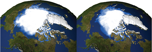
FIGURE 9.1 Sea ice minimums calculated using a 3-year moving average for the period 1979–1981 (left) and 2003–2005 (right). Satellites have made continual observations of Arctic sea ice extent since 1978, recording a general decline throughout that period. Since 2002, satellite records have revealed unusually early onsets of springtime melting in the areas north of Alaska and Siberia. In addition, the 2004–2005 winter season showed a smaller recovery of sea ice extent than any previous winter in the satellite record, and the earliest onset of melt throughout the Arctic SOURCE: NASA (2005). Courtesy of NASA.
implementing more comprehensive approaches to environmental study (NRC, 1999d). The first recommendation of the U.S. National Assessment of Climate Change Impacts (National Assessment Synthesis Team, 2000) calls for a more integrated approach to examining the impacts and vulnerabilities associated with multiple stresses (Figure 9.1). Several effects and vulnerabilities are particularly noteworthy. Changes in the volume of water stored on land as ice and snow are of critical importance to coastal populations and infrastructure because of the effects on sea level. Water resource management is strongly tied to climate and weather, and adaptation strategies are expensive and often require decades to implement. Climate change research has considerable potential to improve the anticipation of adverse health outcomes specifically related to heat mortality, changes in the pattern and character of vector-borne diseases, and air quality. Finally, climate change research is a major factor in improving the ability to be better stewards of natural ecosystems.
This vision recognizes that the demand for knowledge of climate change and variability will intensify. The objective is to improve the ability to anticipate the future and thus increase the capability to use the knowledge to limit adverse outcomes and maximize benefits to society. Failure to obtain that knowledge carries high risks.
OBSERVATIONAL NEEDS AND REQUIREMENTS
The Panel on Climate Variability and Change focused on four fundamental questions in its approach to specific space-based and supporting in situ and surface-based observations required for studies of Earth’s climate: What governs Earth’s climate? What forces climate change? What feedbacks affect climate vari-
ability and change? How is the climate changing? The coming decade will see a challenge to predict better how Earth will respond to changes in atmospheric composition and other forcings. Observations must document the forces acting on the climate system (including solar and volcanic activity, greenhouse gases and aerosols, and changes in land surface and albedo); the characteristics of internal variability that can obscure forced changes and that may evolve in response to climate change; the feedback processes that involve the atmosphere, land, and ocean; biogeochemical cycles and the hydrologic cycle; and climate change itself.
Stripped to fundamentals, the climate is first affected by the long-term balance between sunlight absorbed and infrared radiation emitted by Earth. Thus, key elements to observe are incident sunlight, absorbed sunlight, and emitted infrared radiation. Achieving an understanding of how the system works requires the characterization of the influences affecting the absorbed sunlight and the emitted radiation. The influences include the composition of the atmosphere (such as greenhouse gases and aerosols), the state of the surface (whether snow- or ice-covered and whether vegetated or desert), and the effects of the various atmospheric components and the surface state on radiation loss to space. In addition, physical and chemical processes in the system feed back to affect the composition of the atmosphere and the surface state, such as the processes that affect water vapor and clouds. Other processes and conditions—such as the extent of permafrost, subsurface concentrations of phytoplankton, and the ocean’s thermohaline circulation—are hidden from direct space view. Inferences must be drawn not only from records of space-based observations but also from in situ and remotely sensed observations from surface-based, balloon, and suborbital platforms.
In its consideration of the specific observations to be made and the challenges and opportunities presented by the changes anticipated in the coming decade, the Climate Change and Variability Panel adopted the list of essential climate variables in the 2003 Global Climate Observing System report (GCOS, 2003). The panel then assessed the current observing capabilities and those planned for the coming decade, mostly those from NPOESS. Table 9.A.1 in the attachment at the end of the chapter lists the status of space observations, and in some cases supporting surface-based observations, of critical climate variables. Although the table provides a valuable perspective, its limitations should also be recognized: (1) in some cases, it lists variables that can be obtained through several techniques, but not all techniques are listed; (2) it is limited to satellite observations that are in low Earth orbit, although a number of the objectives listed can also be achieved through retrievals with multispectral imagery and sounder data from platforms in geostationary and other orbits; and (3) few space-based observations can be taken as physical measurements in their own right, and interpretations are often revised as more comparisons are made between inferences based on space-based observations and alternative measures of the physical variables. The evolution of knowledge will require the oversight of scientists and continuous evaluation by the climate research community as space-based observations are transformed into the high-quality long-term records that will be invaluable for climate studies and societal benefit.
The stratosphere plays a unique role in climate forcing and responds in unique ways to global warming, greenhouse gases, solar ultraviolet, and volcanic aerosols (Figure 9.2). In many cases, observed changes are challenging to explain (e.g., Santer et al., 2003; Eyring et al., 2005). As with other variables critical for climate change, consideration of changes in the stratosphere requires long-term climate data records.
Current Status and Needed Improvements
The following description of current observations and needed improvements is based on three basic requirements: (1) multidecadal records of primary climate variables, (2) observations dedicated to inferring
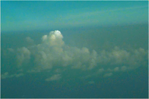
FIGURE 9.2 Marine stratocumulus over the Arabian Sea imbedded in a plume of haze from the Asian subcontinent. The picture was taken from the NCAR C-130 during an Indian Ocean Experiment (INDOEX) research flight. Haze affects the number and sizes of cloud droplets and ice crystals and thereby alters the amount of sunlight that clouds reflect. The effect of haze on clouds is referred to as the aerosol indirect radiative forcing of climate and is among the largest uncertainties that hampers assessments of climate change due to humans. Photo courtesy of Antony Clarke, University of Hawaii.
key processes that affect climate variability and change, and (3) opportunities for scientific exploration, innovation, and discovery.
Multidecadal Records
Increased scientific understanding and improved analysis depend heavily on the length and quality of the observational record—a key need is for space-based and surface-based observations that span many decades.
Current Status of Multidecadal Records
The current scientific strategy for generating and sustaining long-term records by using space-based and ground-based instrumentation of finite lifetimes is to achieve overlap of successive generations of observing systems. Global records of a few decades have been constructed from space-based observations of such variables as sea-surface temperature, sea ice, atmospheric layer temperatures, Earth’s energy budget, and cloud properties. Overlapping observations are crucial for identifying and reducing calibration uncertainties in current instruments that would otherwise exceed the geophysical changes of interest.
The plans summarized in Table 9.A.1 show a heavy reliance on NPOESS for observations of key climate variables during the coming decades. The June 2006 descoping of the NPOESS program fails to satisfy the basic needs of climate science for several reasons. First, instruments essential for climate science have been deleted from the NPOESS program. The following cancellations are of great significance to the climate sciences:
-
CMIS (conical-scanning microwave imager sensor). As currently proposed, the first NPOESS platform (C-1) will not embark a microwave imager-sounder. A solicitation for a “replacement” microwave imager-sounder is proposed for C-2 and beyond.
-
APS (aerosol polarimetry sensor). Aerosol observations for the medium term will rely on the Glory research mission, with a launch anticipated for about 2008.
-
TSIS (total solar irradiance sensor).
-
OMPS-Limb (ozone mapping and profiler suite). With the deletion of the OMPS limb sounder, no monitoring of ozone profile below the ozone peak (where most ozone depletion occurs) is planned during the NPOESS/MetOp period. OMPS-Nadir is still included in the PM orbit.
-
ERBS (Earth radiation-budget sensor). The CERES instrument will fly on C-1, with no plan provided after C-1.
-
ALT (radar altimeter). No clear replacement plan is available other than proposed reliance on a future Navy mission for altimetry.
There remains the option of deploying further DMSPs (one already built and in storage) in the middle-AM instead of PM orbit. CrIS/ATMS and OMPS-Nadir will be flown only on the PM orbits, although VIIRS will be flown on all NPOESS platforms.
The NPOESS bus will have the capability (power and physical space) for the sensors listed above, and the Integrated Program Office (IPO) will plan for and fund integration of the sensors on the spacecraft in the NPOESS program, but only if the instruments are provided from outside NPOESS (by some other agency or partner).
The impact of the proposed changes is significant. As originally proposed, NPOESS lacked the capabilities of the EOS-era satellite systems: VIIRS was missing important water vapor and temperature sounding channels, the capability of CMIS to provide useful passive winds was uncertain, OMPS had much lower horizontal resolution than Aura’s ozone-monitoring instrument (OMI) and lacked limb sounding, and ALT’s orbit made removal of tides a challenge. Compared with the EOS provision of climate data in the current decade, the original NPOESS plan provided a weak set of observations for understanding climate change in 2010 and beyond. The 2006 descoped NPOESS plan will provide a still weaker set of climate observations with substantial gaps in key variables.
Second, the 2006 proposed dates for NPOESS launches indicate delays of several years in data provision:
-
The NPOESS Preparatory Project (NPP) proposed launch date is delayed from 2006 to 2009.
-
The proposed launch dates for NPOESS are 2013 for C-1 (in PM orbit), 2016 for C-2 (in AM orbit), 2020 for C-3 (in PM orbit), and 2022 for C-4 (in AM orbit).
-
There will be no NPOESS platforms in middle-AM orbit; the middle-AM orbit will be covered by MetOp.
The delays of the NPP and NPOESS will be felt immediately if overlap with the EOS Aqua and Aura platforms is lost. For example, the cancellation of CMIS and the delay of any microwave imager until 2016
would create a gap in the record of sea ice concentration and extent, which extends from 1978 to the present. Sea ice is one of the best-documented and most rapidly changing elements in the climate system. In the Arctic, the lowest sea ice extent on record occurred in 2005, and September sea ice extent has been declining by about 8.5 percent per decade. This critical climate record requires continuation. In addition to sea-ice mapping, passive microwave sensors are used to map the onset and extent of melt on the Greenland ice sheet, a key to assessing climate change and the contributions of ice-sheet melt to rising sea level. In view of the fundamental role played by accurate long-term Earth radiation budget measurements and in view of the growing gap expected between the CERES observations on Aqua and the ERBS observations now scheduled for C-1 (proposed date, 2013), there will be a major gap in some of the most fundamental measurements of the climate system.
Finally, regardless of the descoping, the NPOESS program lacks essential features of a well-designed climate-observing system:
-
NPOESS lacks a transparent program for monitoring sensor calibration and performance and for verifying the products of analysis algorithms. Moreover, it lacks the direct involvement of scientists who have heretofore played a fundamental role in developing climate-quality records from space-borne observations. NOAA has initiated plans for scientific-data stewardship (NRC, 2004), but the plans are in their infancy, and NOAA’s commitment to ensuring high-quality climate records remains untested and inadequately funded (NRC, 2005c).
-
NPOESS does not ensure the overlap that is required to preserve climate data records (CDRs). Instead, the NPOESS system is designed for launch on failure of a few key sensors. Failure of NPOESS instruments required for CDRs will probably result in gaps of many months, which will make it difficult to connect long-term climate records and future measurements.
-
The NPOESS commitment to radiometric calibration is unclear, particularly for the VIIRS visible and near-infrared channels used to determine surface albedo, ocean color, cloud properties, and aerosol properties. VIIRS may be flown as the NOAA AVHRRs were flown, with only preflight calibrations, leaving the in-orbit calibrations of those channels to drift. Furthermore, in its current configuration, VIIRS lacks the channels now on MODIS in the 6.3-µm band of water vapor used to detect clouds in polar regions and in the 4.3- and 15-µm bands of CO2 used to obtain cloud heights, particularly heights of relatively thin cirrus.
-
NPOESS only partly addresses the needed measurements of the stratosphere and upper troposphere. The primary variables of the stratosphere—temperature, ozone abundance, and some aerosol properties—will not be provided by NPOESS, because of the loss of OMPS-Limb, APS, and CrIS/ATMS. Other elements are poorly addressed by NPOESS plans, notably measurements of upper-troposphere and stratosphere water vapor, aerosols, and the abundance of ozone-depleting compounds.
This decadal survey was intended to create a vision of the future of Earth observations from space. However, the panel believes that reliance on the operational NPOESS system as a foundation for climate observations in a decadal vision of the climate sciences has failed as a strategy.
Needed Improvements and Products for Multidecadal Records
The collection and maintenance of the long-term records so crucial for understanding of the climate system presents a number of challenges. Clear deficiencies in instrumentation and data analysis are evident in current plans, specifically in the transition to NPOESS. The needed improvements are in two categories: (1) actions required to address the loss of NPOESS measurements viewed as critical for climate research and (2) actions required to improve current and future observation strategies based on the lessons learned
from space-based climate-data acquisition and use in past decades (such as MSU, ISCCP, the Global Aerosol Climatology Project).
-
NASA and NOAA should develop an immediate plan to address the loss of continuity of critical climate measurements. The most important losses for climate include the microwave imager, Earth radiation-budget measurements, total solar irradiance, and stratospheric measurement capability. Considerable care is required to ensure successful stop-gaps and long-term plans. Several options should be considered:
-
Every effort should be made to provide instruments from outside NPOESS (if Congress fails to act to restore NPOESS instruments) to take advantage of the plan to fund integration of these instruments into the NPOESS platforms. Every option should be considered (for example, substitute copies of existing instruments such as MODIS, AMSR-E, and SSM/I for the appropriate lost NPOESS measurements).
-
Every effort should be made to extend the life of Terra, Aqua, Aura, SORCE, and Glory to ensure the longest possible data records and to minimize or eliminate critical data gaps.
-
Much greater effort should be applied to improve current and future observation strategies based on lessons learned from past missions:
-
Improved instrument calibration is required for long-term climate records. Because of the uncertain future of instrument calibration within NPOESS and the likelihood of important data gaps, the development of a space-borne calibration observatory to address accurate radiometry and reference frequencies is essential.
-
For many variables, such as aerosol and cloud properties and water vapor concentrations, it is crucial to avoid orbital drift, which causes a substantial shift of several hours in the local time of the observations. The NPOESS satellites are designed to maintain their Sun-synchronous orbits, and this requirement should not be relaxed.
-
Mission failures and delays can introduce gaps that compromise the detection and understanding of spatial-temporal variability in the climate system. Consequently, until such an understanding of the climate system is achieved and techniques for ensuring radiometric and timing accuracies have been shown to succeed, sequential observations of key climate variables should be overlapped for periods long enough to ensure useful comparisons.
-
Reprocessing of critical data sets is required. Reprocessing of data allows the incorporation of gains in knowledge, the correction of errors in preflight and in-flight calibrations, inclusion of changes in instrument function, and the correction of errors in earlier processing algorithms.
-
Validation of geophysical products inferred from satellite remote sensing is essential. In developing CDRs, validation should be an almost continuous component, providing an independent check on the performance of space-based sensors and processing algorithms.
The Climate Variability and Change Panel believes that the current strategy, of ensuring overlap between measurements should be continued as recommended by GCOS (2003), CCSP (2003), and others (Ohring et al., 2005). For example, the different total-solar-irradiance instruments are tied to radiometric standards but produce measurements that depart from each other by amounts exceeding the claimed uncertainties. The panel recommends that substantial overlap be continued until reliance on absolute measurement standards has been shown to be successful. However, the long-term success of climate measurements cannot always depend on redundancy and therefore requires new approaches, with future instruments designed and built to maintain in-flight calibration to absolute radiometric standards. Temperature and humidity
profiles derived from GPS occultations are likely to gain favor in long-term studies, so measurements of delay need to be tied to high-accuracy frequency standards as are now possible with the ultrastable oscillator flown on GRACE (Trenberth et al., 2006; Bengtsson et al., 2003). Ultimately, reliance on radiance and time measurements that are tied to absolute references will allow the climate record to tolerate gaps for some measurements, but the space-time variability of the climate during the gap in observations must be understood. Until such understanding is achieved and the reliance on calibrated radiances and accurate delays is demonstrated through comparisons of measurements by different instruments on different platforms, the need for overlap remains.
Many of the calls for improvement in the satellite climate record—such as the need for radiometric calibration, launching to preserve continuity as opposed to waiting for instrument failure, and the need to validate space-based inferred products—are themes that run through many previous reports (CCSP, 2003; NRC, 2004; Ohring et al., 2005). Less common are calls that address the culture and infrastructure required to provide the kind of societal benefits that are possible from these satellite observations (see sections “Innovation and Discovery” and “Implications of the Requirements for Developing Climate Data from Satellite Observations” below in this chapter).
Focused Process Studies
Process studies focus on understanding the climate feedback process and are critical to improving climate models. They are generally intensive, short-duration, repeated campaigns with ground-based, airborne, satellite, and modeling components. They usually require frequent, diurnally resolved measurements and a wide variety of simultaneous products—a need typically at odds with the accuracy and stability essential for achieving reliable long-term records.
Current Status of Process Studies
Many climate system processes and many causes of climate variability and change are not fully understood or adequately validated with observations. The large range in climate model estimates of the change in the global surface temperature in response to a doubling of CO2 illustrates how choices in treating these processes—which vary greatly from model to model—can have sizable consequences. Reliable climate simulations require improved treatment of the processes known to be inadequate (NRC, 2003c, 2005b): clouds, aerosols, and convective systems; biosphere-atmosphere interactions; coupling of sea ice, ocean circulation, and icemelt; ice-sheet dynamics; the fluxes of heat, momentum, water, and trace species across the interfaces of ocean-atmosphere, land-atmosphere, ice-atmosphere, boundary layer and free troposphere, troposphere-stratosphere, and ice-ocean; and internal variability, such as the ENSO.
Needed Improvements and Products for Process Studies
There should be a more deliberate effort to focus resources on the most critical weaknesses in predictive models, specifically, the six topics listed above. Networks of surface sites should be distributed to sample the widest possible process over the globe and designed to provide long-term observations of clouds, aerosols, and their effects on surface radiative fluxes; fluxes of sensible heat, evaporation, and evapotranspiration; and concentrations of key trace species and their surface-atmosphere exchange rates. Such observations have proved invaluable in the validation of space-based inferences of aerosol and cloud properties and trace-gas concentrations.1 Properly incorporated in the scheme of climate-data stewardship, the surface-based observations will produce local climatologies that not only enhance the utility of
|
1 |
A good example of the kind of coordinated efforts that can be developed is CEOP (Coordinated Enhanced Observing Period) under the WCRP GEWEX program at http://www.gewex.org/ceop.htm. |
the record derived from satellites but also provide valuable information for society on local trends. Satellite observations provide global perspective and facilitate the incorporation of in situ and surface-based observations to develop regional-scale trends.
Innovation and Discovery
Specific, focused investigations may emerge as urgent priorities because of new knowledge or unexpected events, such as abrupt climate change. For example, a major volcanic or ENSO event, an unusual hurricane season, chronic atmospheric pollution plumes, or new insight into a poorly understood process, such as convection, may catalyze research interest or public attention and lead to substantial societal benefit.
Current Status of Opportunities for Innovation and Discovery
The panel notes that the NASA Earth System Science Pathfinder missions have provided important opportunities for space-based technical innovation and innovative scientific exploration. Three ESSP missions have flown, and two expected to launch in 2008. The timing of future opportunities is highly uncertain. Current budget restrictions have nearly eliminated this source of flexibility in the science that provides opportunities for the community to make critical measurements and to test new technologies. The loss of flexibility and innovation is highly significant. In addition, budget restrictions have led to the cancellation of DSCOVR, a completed satellite that would have provided innovative Earth and space observations from the L1 orbit but now sits in storage.
Needed Improvements and Products for Innovation and Discovery
Climate science needs to have the capability and flexibility to respond promptly and creatively to emerging climate-change issues with the best technology. The panel recognizes that focused investigations can be successful only in the context of a broad understanding of the climate system, which in turn is made possible by the long-term climate data records described above.
Alternative views of Earth through new orbital vantage points, new instrumental and retrieval techniques, and new scientific hypotheses may all advance climate science in unpredictable ways. Some of the greatest challenges in improving the long-term record and in advancing the ability to predict change to benefit society (e.g., issues of calibration, cloud-climate feedbacks, convective processes, and better understanding of surface fluxes) will require greater opportunities for innovation. New knowledge may also result from investigations that were not directed at climate variability and change. The necessary drive to design observing systems that address known deficiencies in knowledge should not be allowed to preclude opportunities for ongoing curiosity-driven discoveries whose tremendous contributions can continue to revolutionize the Earth sciences.
Requirements for Developing Climate Data from Satellite Observations
Involvement of the Climate Science Community
The success of NASA’s Earth Science Enterprise in developing records of climate variables that have been validated over long periods is unprecedented. It was achieved through the involvement of many scientists who represented a wide array of interests in the climate community. The level of involvement should be continued regardless of the source of observations (such as NPOESS).
Accuracy and Time-Space Scales
To secure long-duration climate records, observations must have relative accuracy (precision) sufficient to detect the changes being sought. Ultimately, the acquisition of long-term climate records will require traceability to absolute calibration standards. In principle, once knowledge of the climate system is sufficient, accurate calibration standards may allow relaxation of the requirement that observations with independent instruments be substantially overlapped, at least for some climate variables. Clearly, the records must be able to characterize seasonal and internal variations on appropriate spatial scales so that the relatively small secular changes can be reliably extracted.
Validation of Satellite-Derived Climate Data Products
Validation of climate observations—for example, through comparisons with observations from balloons, aircraft, and ground-based instruments—is crucial to ensure the quality of data sets. For example, the panel notes that the Department of Energy (DOE) Atmospheric Radiation Measurement (ARM) sites and the federation of AERONET sites have been heavily relied on to characterize cloud and aerosol properties and temperature and moisture profiles used in the validation of satellite-derived products. The operational weather network is also important. The existing networks should be maintained. The networks should also be expanded in geographic extent and the types of measurements made. Top-of-the-atmosphere radiative forcing is often considered interchangeable with climate forcing, but new insight calls for equal attention to the surface energy budget (NRC, 2005b). The panel calls for the development of surface-based networks focused on climate observations and the development of the associated climate records as set forth in climate-stewardship principles.
Use of Climate Records in Climate Model Development
Because simulations with climate models provide useful climate information, future observational systems need to recognize impending and ongoing model changes and improvements that will require validation and observational inputs. For example, global climate models are expanding to include higher altitudes (top of the atmosphere and above), delineate more surface features (e.g., vegetation on land), utilize higher spatial and vertical resolution, and add more detailed calculations for various processes now incorporated only through rough approximations (simple parameterizations). Quantitative data sets will be needed not only for model validation but also for assimilation (e.g., cloud assimilation). Because climate records have played and continue to play a fundamental role in climate model validation and development, the need for an Earth radiation-budget continuation mission is reiterated. There is also a pressing need for measurements of the vertical distribution of water vapor, cloud-ice and liquid-water path, and convective processes.
Large-Volume, Accessible Archives of Long-Term Climate Observations
Climate science requirements have substantial implications for data management, distribution, access, reprocessing, scientific oversight, and value-added analyses that are all part of comprehensive data stewardship. Those activities are crucial to provide the data sets that prove useful for a wide array of climate science investigations, are easy for scientists in diverse disciplines to access, and facilitate the generation of accessible climate products for societal needs. The panel envisions a virtual observatory that provides access to multiple data records and facilitates analysis of disparate observations and integration with model
results. Ultimately, a new climate service (NRC, 2001b) may best meet the needs for climate science analysis, simulations, products, understanding of impacts, and forecasts, and provide a coherent interface with public, political, and other scientific disciplines. As noted above, a commitment to very-long-term data stewardship is also required.
HIGH-PRIORITY SATELLITE MISSIONS
The Climate Variability and Change Panel approached the assessment of responses to the decadal survey’s requests for information (RFI)2 and future observational needs from three perspectives: (1) A science-traceability matrix (Table 9.A.1 in the attachment at the end of the chapter) was constructed that connects science questions to elements of the climate system, candidate missions, and current and planned capabilities in order to identify gaps or inadequacies in the space-based observing system. (2) Responses to the RFI were characterized as elements of the climate record that must be maintained or extended, observations required for understanding processes, or exploratory research. (3) A disciplinary perspective was taken to determine specific priorities for different fields of research. The results of the three perspectives were generally consistent and gave some level of confidence in the panel’s set of observational priorities. For each important climate measurement identified by the GCOS second adequacy report (GCOS, 2003), the science-traceability matrix (Table 9.A.1) lists the measurement, strategy, current status, follow-on for 2010–2020, and related RFI responses and illustrates the set of planned and candidate missions.
The matrix is not intended to be exhaustive but rather is a vehicle for assessing unmet needs in climate research. It is consistent with previous analyses of climate issues and research needs (e.g., IPCC, 2001; NRC, 2000a,b,c, 2003a,b,c, 2004, 2005b,c). Furthermore, the entries in Table 9.A.1 should be viewed only as “recommended strategies” for making a particular set of observations in light of the unending need to refine interpretations of space-based observations. Some of the approaches listed in Table 9.A.1, like those involving Earth’s radiation budget components, have benefited from decades of advancement; others, such as the characterization of cloud properties to come from the millimeter-wavelength cloud radar on CloudSat, are just beginning.3
The matrix approach, combined with the perspective in the “Overview” and analysis of climate science requirements in the “Observational Needs and Requirements” section above, has guided the development of a proposed set of missions. The missions are not intended to address the problems in the current NPOESS program. The inadequacies of NPOESS, specifically the recently proposed cancellations, should be addressed separately as soon as possible so that a progressive vision of the Earth sciences can be implemented.
The types of proposed missions include two categories essential to advance climate research and applications, both of which are needed to improve climate predictions for the benefit of society: (1) missions identified as addressing major gaps and priorities and (2) innovative concepts that extend beyond current instrumentation.
Addressing Identified Gaps and Priorities in Climate Change and Variability
Four missions are identified as addressing major gaps and priorities in climate research and applications (Table 9.1). Each includes specific proposals to address key science questions and specific instruments.
|
2 |
The RFI submission process is discussed in Chapter 2. The RFI is shown in Appendix D, and an indexed list of the responses is given in Appendix E. The compact disk that contains this report includes full-text versions of the RFI responses. |
|
3 |
Information about CloudSat is available at http://cloudsat.atmos.colostate.edu/data. |
TABLE 9.1 Climate Change and Variability Panel Priorities and Related Space-based Missions
|
Summary of Mission Focus |
Variables |
Sensor Types |
Coverage |
Spatial Resolution |
Frequency |
Synergies with other Panels |
Related Planned or Integrated Missions |
|
Cloud, aerosols, ice, carbon (Mission 1) |
Aerosol properties, cloud properties, ice sheet volume, sea ice thickness, ocean carbon, land carbon |
Scanning dual-wavelength lidar, multiangle visible/near-IR polarized spectrometer, hyperspectral imager, radar |
Global |
30–50 m (hyperspectral), 1 km (polarimeter) |
Days |
Health Ecosystems Water Weather |
ACE ICESat-II |
|
Radiance calibration (Mission 2) |
Radiation budget; radiance calibration for long-term atmospheric and surface properties; temperature, pressure,and water vapor; estimates of climate sensitivity |
Shortwave spectrometer, thermal IR spectrometer, filtered broadband active-cavity radiometer, GPS, scanning radiometer, SIM |
Global |
— |
— |
Weather |
CLARREO GPSRO |
|
NPP/NPOESS (ERB sensor) |
|||||||
|
Ice dynamics (Mission 3) |
Ice sheet surface velocities, estimate of ice sheet sensitivity |
InSAR |
Global |
Meters |
— |
Solid Earth Water |
ACE DESDynl |
|
NPOESS (CMIS) |
|||||||
|
Ocean circulation, heat storage, climate forcing (Mission 4) |
Surface ocean circulation, bottom topography, ocean-atmosphere interaction, sea level |
Swath radar altimeter, scatterometer |
Global (or near-global) |
|
Twice a day |
Solid Earth Water Weather |
SWOT GRACE-II XOVWM |
Climate Mission 1: Clouds, Aerosols, and Ice Mission (with Proposed Carbon Cycle Augmentation)
Mission Summary—Clouds, Aerosols, Ice, and Carbon
|
Variables: |
Aerosol properties, cloud properties, ice-sheet volume, sea-ice thickness, ocean carbon, land carbon |
|
Sensors: |
Scanning dual-wavelength lidar, multiangle visible/near-IR polarized spectrometer, hyperspectral imager, radar |
|
Orbit/covemge: |
LEO/global |
|
Panel synergies: |
Health, Ecosystems, Water, Weather |
Some of the most important uncertainties in global climate change are the role of different types of aerosols in Earth’s radiation budget and hydrologic cycle; the importance of black carbon aerosols in suppressing clouds, altering precipitation and heating the atmosphere; the rate of change in ice sheet volume; the rate at which the oceans take up and sequester carbon; and the change in land carbon storage and vegetation characteristics. Those topics have been discussed by the IPCC, the decadal survey committee’s
interim report (NRC, 2005c), and the RFI responses submitted for this decadal survey. The panel proposes a baseline mission, possibly to be flown in formation with the 1:30 NPOESS satellite, that will address the first three items with a potential augmentation that would address the carbon cycle, that is, the last two items.
Aerosol-Cloud Forcing
Aerosol climate forcing is similar in magnitude to CO2 forcing, but the uncertainty is five times larger (IPCC, 2001; Hansen and Sato, 2001). This assessment of uncertainty has not changed much from the earlier IPCC reports. Among the reasons for the uncertainty are that aerosols have a short lifetime in the atmosphere (days to weeks) and not all aerosols are alike (Kaufman et al., 2002b). Furthermore, aerosols have an effect on cloud formation (the indirect effect) that amplifies their importance in the climate system (Twomey, 1977; Albrecht, 1989; Kaufman et al., 2005; Koren et al., 2005; Andreae et al., 2005). Black carbon (BC) aerosols and other light-absorbing particles intercept incoming solar radiation, cooling Earth’s surface, heating the atmosphere above (Satheesh and Ramanathan, 2000), and affecting cloud formation (Ackerman et al., 2000, Koren et al., 2004; Kaufman and Koren, 2006). Some calculations suggest that the BC-aerosol contribution to global warming may be as much as +0.5 W/m2, one-third of CO2 forcing (Haywood and Boucher, 2000; Jacobson, 2001). Current estimates of BC concentration and effects on the climate system have a large uncertainty (Tegen et al., 2000).
A primary goal of Climate Mission 1 (CM1) is to reduce the uncertainty in the effects of aerosol forcing and the effects of aerosol feedbacks on cloud formation. As climate continues to change over the next 10 years and as urban pollutant emissions associated with aerosols continue to change, the Earth radiation budget and the hydrologic system will respond. Those changes and their effects on the climate system can be documented with a payload that includes a cloud-aerosol lidar, a multiangle spectrometer-polarimeter, and a cloud radar. The mission could fly in formation with the 1:30 NPOESS satellite (C-1), which, with the VIIRS instrument, would provide visible and NIR bands used in aerosol retrievals. Combined with the NPOESS instruments, the instrument package of CM1 would mimic the relevant capabilities of the A-Train (Aqua MODIS, Aura OMI, CloudSat, CALIPSO, POLDER, and Glory) while substantially advancing the technology to better accuracy, finer resolution and greater spatial coverage—all necessary to understand aerosol-cloud interaction. The package would also address ice sheets and, with the addition of a hyperspectral imager on the same platform or coflying on its own satellite, can address the ocean and land carbon goals mentioned above.
The primary instrument on CM1 is a multiangle spectrometer-polarimeter like APS but with a POLDER-type wide cross-track swath (±50°) and finer spatial resolution for better retrieval of cloud microphysical information. The spectrometer-polarimeter will have the capability to observe the cloud polarized phase function, or the “rainbow” (Breon and Goloub, 1998), and thus retrieve important cloud microphysical information necessary to understand the onset of precipitation in convective clouds. Such studies are not possible with the current, 100-km resolution. The instrument can determine the scattering properties of aerosols over a wide range of wavelengths and with the polarization information can provide information on black carbon. If aerosols over the ocean both on and off the glint angle are observed, their absorption properties can be determined and the black carbon inferred (Kaufman et al., 2002a). Experience with the TOMS, EOS MISR, and POLDER sensors (POLDER, Breon et al., 2002; MISR, Kahn et al., 2001; TOMS, Torres et al., 1998) shows that multiangle measurements at several wavelengths, including the UV combined with polarization, constitute provide an optimal strategy.
The second proposed instrument is a cloud-aerosol lidar. Near-simultaneous lidar measurements of aerosol height are critical for retrieving aerosol properties and the effects of aerosols on clouds. This approach will soon be tested with CALIPSO, which has been successfully launched into the A-train
formation with the Aqua and CloudSat missions (Figure 9.3).4 The CALIPSO lidar provides a single nadir measurement, but technology exists to provide a multibeam system that can produce a much wider cross-track swath.
The third instrument on CM1 is the cloud radar. The cloud radar is needed to measure cloud formation, cloud hydrometeor properties, and cloud morphology in response to aerosols. The primary cloud processes of interest to CM1 include the onset of cloud formation, cloud morphology, the role of aerosols in the development and evolution of cloud hydrometeor profiles, and the microphysical basis of the resulting cloud radiative properties. The observational goals for a cloud profiling radar (CPR) therefore include estimating the cloud droplet concentration and size distribution and the cloud hydrometeor type. The goal of those measurements is to estimate the liquid-ice water path, the optical path length and extinction coefficient, and the variability of these characteristics as related to the effects of aerosols.
The cloud radar must be sensitive to cloud droplets well below the precipitation size range. Cloud radar measurements should mesh smoothly with the lidar measurements of aerosol and nascent cloud properties. Those goals dictate the choice of a short wavelength that will be optimized for the smallest hydrometeors and the smallest reasonable sampling volume, or spot size. Experience indicates the choice of 94- and 35-GHz radar and even higher-frequency radiometer systems for measurement of such cloud properties. For spacecraft, the CloudSat5 and EarthCARE6 CPR designs can be used. The antennas for both CPR systems are offset paraboloids. The advantage of such systems is the extremely low side lobes, but they can operate only in the nadir. An alternative approach is to use patch antennas that can steer the beam to multiple positions across the track. Patch antennas increase the side lobes and may limit peak power and system reliability. Scanning to about ±10° should be possible without much degradation of vertical resolution.
Ice Sheet and Sea Ice Volume
Mass balance of Earth’s great ice sheets and their contributions to sea level are key issues in climate variability and change. The relationships between sea level and climate have been identified as critical subjects of study in the IPCC assessments, the U.S. Climate Change Science Program Strategic Plan, and the U.S. IEOS. Because much of the past and future behavior of ice sheets is manifested in their shape, accurate observations of ice-elevation changes are essential for understanding their contributions to sea-level rise. ICESat, using a dual-wavelength lidar with high altimetric fidelity, has provided episodic but high-quality topographic measurements that allow estimation of ice sheet volume (Figure 9.4). High-accuracy altimetry is also proving valuable for making long-sought estimates of sea-ice freeboard and hence thickness, which is a measure essential for ice-volume determinations, ice-thickness-change determinations, and estimations of the flux of low-salinity water out of the Arctic basin and into the marginal seas. Altimetry is the best (and perhaps only) technique for making this measurement on basin scales and with seasonal repeats. That is particularly important for climate change studies because sea ice areas and extents have been well observed from space since the 1970s and have been shown to have trends that are both statistically and visually significant, but sea ice thicknesses do not have such a record. As climate change continues, ongoing frequent measurement of both land ice (monthly) and sea ice (daily) volume will be needed to determine trends, update assessments, and test climate models. The cloud-aerosol-ice lidar proposed above can provide altimetric information with the precision of the ICESat instrument and allow fundamental questions of ice sheet and sea ice volume to be addressed. Combining altimetry with a gravity measurement
|
4 |
The other members of the A-train are the AURA and PARASOL spacecraft. |
|
5 |
CloudSat CPR specifications from http://cloudsat.atmos.colostate.edu/instrument. |
|
6 |
See http://esamultimedia.esa.int/docs/EEUCM/EarthCARE_handout.pdf. |
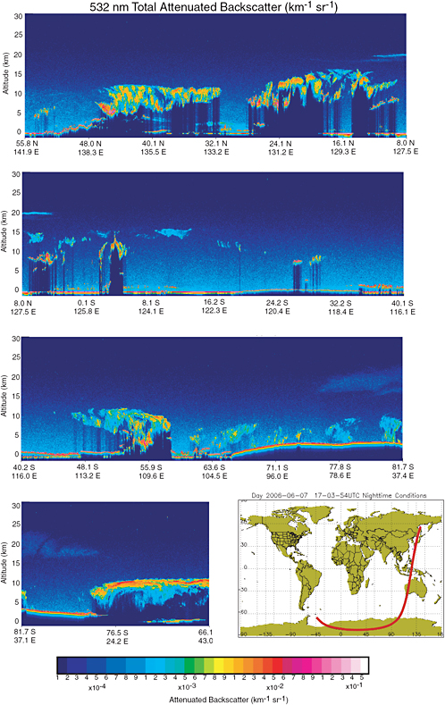
FIGURE 9.3 First observations obtained with the CALIPSO lidar launched on April 28, 2006. The attenuated backscatter returns show, in addition to the deep convective clouds at middle to high latitudes and the tropics, a stratospheric aerosol plume at 20 km over the tropics from the eruption of Soufriere 2 weeks before the observations and polar stratospheric clouds, also at 20 km over Antarctica. The lidar observations in conjunction with other A-train data promise many new insights into clouds, aerosols, and cloud-aerosol interactions. SOURCE: Courtesy of D.M. Winker and the CALIPSO Science Team, NASA Langley Research Center.
at a higher precision than GRACE would optimally measure changes in ice sheet volume and mass and contribute directly to determining the ice sheet contribution to sea-level rise.
Orbit and Timing Issues
For aerosol and cloud measurements, the ideal configuration would be to fly CM1 at the same orbit altitude as the NPOESS spacecraft (about 820 km). That would allow CM1 to take advantage of the VIIRS and near-IR sensors and the Earth radiation-budget measurements. CM1 would then provide the aerosol and cloud polarimetry measurements that should have been provided by APS on the original NPOESS payload. One technical difficulty with this payload is that an 820-km orbit is a challenge for the lidars because their signal diminishes with increasing altitude as the inverse square (higher orbits require more power and reduce the lifetime of the lidar). A lower orbit would be feasible if the VIIRS visible and IR bands could be included in the polarimeter. Another problem is that the Sun-synchronous polar orbit with a 98° inclination is not ideal for ice-sheet measurements, because polar coverage is reduced. The ICESat mission, for example, is in a non-Sun-synchronous polar orbit at 600 km with a 94° inclination,which provides greater coverage of the polar regions.
Given the rapidity of the change in polar sea ice and ice sheets (e.g., Yu et al., 2004; Zwally et al., 2005; Parkinson, 2006) and the remaining lifetime of ICESat, a critical gap would arise if the new measurements were not made before the launch of CM1 (possibly in 2015) and the C1 NPOESS mission. Hence, the panel advocates the earlier launch of an “ICESat-lite” mission, carrying the red but not the green ICESat laser and following the ICESat orbit, to continue the assessment of polar ice changes. Unofficial costing of such a mission suggests that it can easily fit within the ESSP budget and could be developed for launch by 2010.
Proposed Augmentation—Carbon Sources and Sinks
The proposed payload can be augmented at little additional cost to meet important objectives for carbon sources and sinks. Although the forcing uncertainty due to long-lived greenhouse gases is small, there are substantial uncertainties in the sources and sinks of carbon that limit the predictability of future CO2 abundances. The uncertainty in the CO2 budget may be due either to additional ocean sinks or to increases in land biomass storage through the regrowth of forests.
Land Carbon. Understanding land carbon storage is a critical factor in predicting the growth of atmospheric CO2 and subsequent global climate change. The cloud-aerosol lidar can also be used to measure the canopy depth and thus estimate land carbon storage, as demonstrated with aircraft that used the LVIS sensor (Dubayah et al., 1997). An approved but canceled ESSP mission (the vegetation canopy lidar, VCL) ran into technological problems that have since been solved. Furthermore, new technology has recently been developed to allow lidars to produce multiple measurements across the swath, greatly increasing the
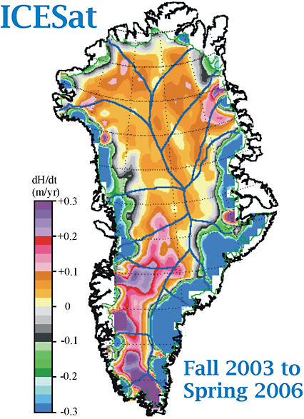
FIGURE 9.4 Elevation change (dH/dt) of the Greenland ice sheet between fall 2003 and late spring 2006 from ICESat data. ICESat’s laser altimeter measures elevations over the entire ice sheet for the first time, including the steeper margins where mass losses are largest. The large areas of thinning (dark blue) on the upper left (west) and lower right (east and southeast) are where recent GRACE analysis (Luthcke et al., 2006) showed significantly increased mass loss compared with the period 1992–2002 (Zwally et al., 2005) and where outlet glaciers have accelerated (Rignot and Kanagaratnam, 2006) and icequakes have increased (Ekstrom et al., 2006). Significant inland growth,especially in the southwest, is due at least in part to increasing precipitation. The high-resolution laser mapping detects alternate areas of thickening and thinning around the ice-sheet margin, and changes inland, providing details of the competing processes that affects the mass balance as climate changes. Results are from repeat-track analysis (eight sets of 33-day tracks), which is enabled by ICESat’s precision off-nadir pointing to reference tracks to ±100 m. SOURCE: Courtesy of Jay Zwally, NASA ICEsat project scientist.
coverage. The limited ICESat data over land are also being used for canopy height estimation. Combined with a lidar biomass-volume assessment, the ideal land-carbon mission would include a hyperspectral imager to assess vegetation type. Hyperspectral measurements of reflected solar radiation with a spectral resolution of 5–10 nm in the range of 320–2,500 nm, including bands in the thermal infrared (10–12 µm) and a spectral resolution better than 0.5 nm in a few spectral windows from 350 to 765 nm and in the O2 A-band (760 nm) for cloud height, would provide the basic capability of land vegetation type assessment. Horizontal resolution of 30–50 m with a 60-km swath or less would be ideal. The narrow swath suggests that the instrument should point to special targets as the EO-1’s Hyperion instrument does. The additional thermal infrared bands can be used to track water temperature and estimate thermal cloud properties.
Ocean Carbon. The ocean is a rapid processor of carbon and constitutes a major uncertainty in the global carbon flux. The estimated ocean carbon uptake is about as large as the total uncertainty in the carbon budget (IPCC, 2001), and estimates of O2:N2 flux ratios suggest that the current estimates may be too large by a factor of two (Plattner et al., 2002). Carbon uptake by the ocean is also influenced by climate change through changes in wind stress and salinity that produce a concomitant response in zones of upwelling, mixed-layer depth, aeolian fertilization, marine ecosystems, and the export of carbon. All of those changes together will alter the oceanic uptake of CO2. Evidence of such control is seen in the changes in the growth of atmospheric CO2 during the last El Niño, in which a roughly 5 percent change in net primary production occurred. In the ocean, net primary production is dominated by phytoplankton growth (Behrenfeld et al., 2001), and the ideal measurement combines a spectrometer to measure chlorophyll and dissolved organic matter (DOM) and a lidar to measure the aerosol optical depth to correct the passive visible and UV measurements of the spectrometer. The combination of instruments is similar to the aerosol-cloud-ice payload, so both science objectives can be met if the relevant visible and UV bands can be added to the spectrometer and the hyperspectral imager. The hyperspectral imager meets the requirement of high horizontal resolution in coastal zones, and the spectrometer meets the requirement of a broad swath in pelagic zones.
Summary—Climate Mission 1
The primary objective of Climate Mission 1 is to quantify aerosol-cloud interactions. The primary instruments are a multibeam altimetric lidar, a spectrometer-polarimeter, and a cloud radar. Another key objective is to obtain ice sheet and sea ice topography measurements and from them to estimate sea ice thickness and ice volume change. With the addition of a fourth instrument, a hyperspectral imager, either included with this payload or as a co-fly, the CM1 mission could measure land carbon storage and ocean carbon fluxes. CM1 is envisioned as possibly flying with the C-1 NPOESS satellite to take advantage of its VIIRS, CrIS/ATMS, and Earth radiation-budget sensors. CM1 provides critical polarimetry and cloud measurements descoped from NPOESS. Details are listed in Box 9.1.
CM1 (with C-1) would be in a Sun-synchronous orbit at 98.7° inclination, with a launch in about 2015. With that inclination, an important area of the Antarctic ice sheet and the sea ice of the central Arctic Basin will not be seen by the CM1 altimetric lidar. Rapid ice sheet changes are among key climate issues, and an earlier launch of an “ICESat-lite” mission in an orbit appropriate for polar ice coverage would provide closer continuity with ICESat data. The panel believes that “ICESat-lite” would fit into the small-mission category.
Climate Mission 2: Radiance Calibration, Time-Reference Observatory, and Continuation of Earth Radiation-Budget Measurements
Mission Summary Radiance Calibration
|
Variables: |
Radiation budget; radiance calibration for long-term atmospheric and surface properties; temperature, pressure, and water vapor; estimates of climate sensitivity |
|
Sensors: |
Shortwave spectrometer, thermal-IR spectrometer, filtered broadband active cavity radiometer, GPS, scanning radiometer, SIM |
|
Orbit/coverage: |
LEO/global |
|
Panel synergy: |
Weather |
A strategy based on overlapping missions has been the primary tool to ensure continuity of measurements. However, the long-term success of climate measurements requires new approaches, with future instruments designed and built to maintain in-flight calibration traceable to absolute radiometric standards. Ultimately, reliance on radiance and time measurements that are tied to absolute references will allow the climate record to tolerate gaps for some measurements once the space-time variability of the associated variables has been characterized and is largely understood. Temperature and humidity profiles derived from GPS occultations require the accurate measurement of delays from GPS or equivalent systems, so a time reference measurement based on ultrastable oscillators as flown on GRACE is required. The panel recommends the development of a Radiance Calibration and Time Reference Observatory (RCTRO) that will help to ensure the long-term success of climate measurements by providing absolute radiometric references and accurate time-delays to compare with the various Earth-viewing instruments on orbiting platforms.
Nonetheless, until sufficient understanding of the variability in the climate record is achieved, the requirement for measurement overlap remains. One subject needing immediate attention is the threat of a considerable gap in highly accurate measurements of Earth’s radiation budget. For more than two decades, Earth radiation-budget observations from ERBE and CERES have been used to assess climate model simulations of the radiation budget (Wielicki et al., 2002), cloud radiative forcing (Potter and Cess, 2004), and sunlight reflected by aerosols over oceans (Loeb and Manalo-Smith, 2005). The design of Earth radiation-budget sensors coupled with sustained efforts over the years to ensure radiometric accuracy and to validate the inferred radiative fluxes (Loeb et al., 2003a,b, 2005) has led to a long-term record of highly accurate measurements (Figure 9.5). Such measurements allow the use of Earth’s net radiative flux to follow trends in the total energy stored by the global oceans (Wong et al., 2006). The trends are typically on the order of 0.5 Wm−2 per decade and thus demonstrate the feasibility of achieving accuracies comparable with those of the radiative forcing predicted for the 21st century. As the record is extended, comparisons of the net radiative flux at the top of the atmosphere with independent measures of ocean heat storage will begin to constrain estimates of global-scale climate sensitivity. But the accuracy has been achieved through overlapping observations of the broadband radiances from multiple sensors—the wide-field-of-view sensors from ERBE and the CERES scanning radiometers on the Tropical Rainfall Measuring Mission (TRMM), Terra, and Aqua (Figure 9.6). Without the benefit of such overlap, the ability to achieve and demonstrate the long-term stability of the energy-budget measurements would have been seriously compromised. For those reasons, the panel also recommends an Earth Radiation Budget Continuation Mission or the flight of CERES on NPP to bridge the growing gap between the CERES observations from Terra and Aqua and those of the NPOESS ERBS planned for C-1 (2013 launch).

FIGURE 9.5 Five-year record of monthly mean anomalies in reflected sunlight (Wm–2) derived from the CERES broadband radiometers and cloud cover derived from the MODIS 1-km imager. Cloud cover and reflected sunlight are highly correlated, and variations in both, when averaged over Earth and for monthly means, are remarkably small, about 0.5 percent for both quantities. The results illustrate the high stability achieved with the NASA Earth-Observing System sensors. SOURCE: Loeb et al. (2007). Reproduced by permission of the American Geophysical Union.
Radiance Calibration and Time-Reference Observatory
Estimation of trends in the climate records of the TIROS-N series has been complicated by the lack of radiometric calibration of instruments on different platforms. Trend estimation direct from the measurements is further complicated by drifts in the orbits of the operational satellites, which cause shifts in the local times of the observations and in orbit altitudes; orbit drift is not a problem for modern assimilation systems. In the EOS era, effective orbit control has largely eliminated problems associated with orbit drift, but maintenance of the radiometric calibration of sensors on different platforms remains a challenge. Onboard calibration, particularly of reflected sunlight, was not undertaken for the TIROS-N series of satellites. It remains to be seen whether it will be undertaken with NPOESS. Lack of calibration of the short-wave channels compromises long-term measurements affected by aerosol and cloud properties and by surface
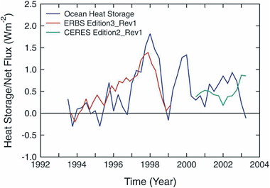
FIGURE 9.6 ERBE and CERES observations of the net radiation budget track observations of the net heat storage of the global oceans. Long-term observations of the net radiation budget and heat storage of the oceans together will challenge the ability of climate-model simulations to predict major climate feedbacks, such as water-vapor and cloud feedbacks, and the climate response. SOURCE: Wong et al. (2006). Copyright 2005 by the American Meteorological Society.
albedos. The panel believes that a mission should be developed to provide in-space calibration standards with which to monitor the calibration histories of sensors measuring reflected sunlight, emitted infrared radiation, and GPS delays. Such a mission would overcome the long-standing problem of cross-platform instrument comparison. It would fulfill a principal objective of the vision (outlined in Part I of this report) by meeting the continuing need to maintain the long-term accuracy of many space-based observations (NRC, 2004; Ohring et al., 2005).
The concept of the Radiance Calibration and Time-Reference Observatory (RCTRO) arose from information in RFI responses (Climate Benchmark Constellation and Climate Calibration Observatory RFIs). RCTRO would carry a short-wave spectrometer (0.2–3 µm) and a thermal infrared spectrometer (3–100 µm), both with a nadir field of view of about 100 km, and two broadband active cavity radiometers (0.2–100 µm) with nadir fields of view of about 500 km, with one filtered (0.2–3.5 µm) for short-wave radiances. The relatively large fields of view are proposed to simplify the designs of the instruments and to enhance the radiometric signal-to-noise ratio to achieve high radiometric accuracy. The radiometers would be built with the utmost radiometric accuracy feasible in such instruments and would be designed to maintain accurate radiometric calibration on orbit through onboard sources and solar and lunar calibrations. RCTRO would also carry a GPS receiver that has a high-precision, high-stability oscillator for accurate time delay measurements.
The strategy would be to incorporate at least three satellites into RCTRO. Two satellites would be placed in precessing orbits separated by 6 hours in equatorial crossing time. The third satellite would provide a backup in the event of failure of one of the orbiting satellites, thereby ensuring overlap of observations as desired for climate-data records (CCSP, 2003; Ohring et al., 2005). The satellites would have a nominal lifetime of 6 years and would underfly all relevant space-based sensors on both operational and advanced-concept measurement-mission satellites. The observations from the high-spatial-resolution imagers and sounders would be mapped to the fields of view of the standard short-wave and long-wave spectrometers.
The spectrometers would have sufficient spectral resolution to reconstruct the filter functions of the instruments being calibrated. Broadband radiometers are included to check the consistency of the integrated radiances from the spectrometers and to provide calibration checks for future Earth radiation-budget sensors that the panel recommends be carried on NPOESS. Both the spectrometers and the broadband radiometers would be designed to adjust Sun-target-satellite geometry to map the performance of the various imagers and sounders across the angular domains of their scans.
Because much of the infrastructure for this active limb-sounding technique already exists in the form of GPS satellites, GPS radio occultation offers an ideal method for benchmarking the climate system (Goody et al., 1998; Trenberth et al., 2006). GPS radio occultation profiles from low Earth orbit provide the refractive properties of the atmosphere by observing the time delay of GPS signals induced by the atmosphere as the ray path descends in a limb-sounding geometry. The index of refraction is directly related to pressure, temperature, and water vapor concentration in such a way that the refractive index can be easily simulated from model output. Moreover, GPS occultation offers an accurate measurement of geopotential heights on constant-pressure surfaces throughout much of the troposphere and stratosphere and thus offers the opportunity to directly observe thermal expansion of the troposphere in response to forcing. GPS radio occultation is traceable to international standards because the raw observable quantity, the delay induced by the atmosphere on the occulted GPS signal, can be tied directly to the international definition of the second by a near-real-time chain of calibration.
Future GPS sounding measurements will be enhanced by the availability of the Galileo satellite navigation system, which is to be implemented by the European Union in the near future. The Galileo system will double the number of available transmitters for Global Navigation Satellite System (GNSS)-based atmosphere sounding. Also, the signals of the Russian GLONASS satellites have the potential to be used for the application of atmosphere sounding techniques. If GPS occultation data sets are to be used in climate change studies, measurements from various low-Earth-orbiting satellites (e.g., CHAMP, Oerstead, and COSMIC) with their attendant onboard oscillator drifts and the different GNSS implementations will require a comprehensive calibration effort. RCTRO satellites carrying a GPS receiver with a high-accuracy ultrastable oscillator (USO), such as that of the GRACE receiver, will facilitate relative calibration of the various occultation measurements. In view of the importance of the occultation measurement and the accurate positioning of the satellite for other sensor measurements, GPS receivers should be a standard part of both NASA and NPOESS low-Earth-orbit payloads. Accurate, long-term radiometric calibration of space-based sensors and time-referencing of GPS receivers will greatly facilitate detection of trends in a large number of climate variables.
Earth Radiation Budget (ERB) Continuity
The Earth radiation budget has been measured continuously from space for more than 2 decades. The CERES project has demonstrated the capability of obtaining highly accurate radiative fluxes when the broadband radiances obtained with the radiometer are interpreted through scene identification achieved through the analysis of collocated multispectral imagery data (Loeb et al., 2003a, 2005). The identification allows the selection of appropriate anisotropic factors that are used to convert the CERES broadband radiances to radiative fluxes. The panel calls for the refurbishing and launching well before 2013 of the CERES Flight Model-5 (FM-5) scanning radiometer, which is now in storage and currently in line to become the NPOESS ERBS on C-1. The refurbishments are minor and entail activities that have been recommended for the NPOESS ERBS: change the mirror-attenuator mosaic to improve the on-orbit solar calibrations and replace the CERES narrow (8–12 µm) window filter, now constituting one of the three CERES channels, with the ERBE long-wave filter. The panel recommends that the CERES FM-5 be launched on NPP so that scene identification can be performed with the collocated VIIRS imagery. The panel also recommends the development of the NPOESS ERB sensors that were to be flown on the afternoon satellites (now C-1 and C-3).
Like the Earth radiation budget, the total flux of sunlight reaching Earth, has also been measured continuously from space for more than two decades. The measurements have established that total solar irradiance varies with solar activity. The solar spectral irradiances are known to be rather variable at UV wavelengths and much less variable at visible and near-IR wavelengths. The wavelength dependence, however, is poorly known because of an almost complete lack of observations before the launch of the SORCE mission in January 2003. Since then, the spectral irradiance monitor (SIM) on SORCE has measured the solar spectral irradiance from 0.2 to 2 µm. NPOESS was proposed with TSIS (total solar irradiance sensor, a combination of a total irradiance monitor, TIM, and SIM), but TSIS is now to be eliminated. The lack of a continuation in SIM measurements threatens to end the spectral-irradiance record before a complete solar cycle has been observed. The panel thus recommends that SIM be added to NPP or Glory to ensure the continuation of the spectral measurements to cover at least a full solar cycle.
The existing SIM instrument meets the needs for solar irradiance in its current configuration, but a number of enhancements would improve its performance and the overall value of the measurement. Extended wavelength coverage further into the near infrared would provide calibration data for other near-infrared sensors, spectral information over a larger fraction of the total solar irradiance, and solar variability data at the longer wavelengths. Improved absolute detector technology with improved dynamic range and response time would ease planning and scheduling and make the instrument a better match for future, yet to be defined spacecraft.
Summary—Climate Mission 2
The RCTRO is designed to provide (1) radiometric calibration standards for all space-based sensors that measure radiances from the UV through the far infrared, thereby achieving accurate narrowband radiances that are the starting point for developing long-term records of atmospheric and surface properties needed to advance the science of climate and climate change, and (2) a time reference standard to accurately determine the relative time delay measurements of the various GPS navigation satellite systems that will be launched in the coming decade. The RCTRO is a system of three satellites—two in precessing orbits separated by 6 hours and a third ready to launch in the event of a failure of one of the orbiting satellites. The satellites carry spectrometers covering the spectrum from the UV to the far infrared with sufficient spectral resolution to create accurate filtered radiances and spectral radiances of the various space-borne narrowband sensors and spectrometers in orbit on various platforms. It also carries two broadband radiometers—one to measure the total radiance and the second to measure short-wave radiances, 0.2–3.5 µm, to serve as a calibration standard for Earth radiation-budget sensors. Radiometrically accurate radiances are the starting point for long-term climate records, and the panel recommends the development and deployment of the RCTRO early in the NPOESS era.
Highly accurate measurements of solar irradiances along with the energy budget of Earth represent fundamental climate variables that have revealed considerable information concerning the workings of the climate system; extension of the record of accurate measurements into the NPOESS era should lead to constraints on radiative forcing and climate sensitivity. Given the threat of a gap in the highly accurate multidecade record of Earth radiation-budget measurements, the panel recommends that the CERES FM-5, now awaiting launch on NPOESS C-1, be refurbished and flown on NPP. In addition, a copy of SIM should be added to the NPP or Glory payloads to continue the UV to near-IR solar spectral irradiance measurements started with SORCE. This recommendation also calls for the development of the NPOESS ERB sensor with TSIS for launch on NPOESS C-1 and C-3. Ultimately, the long-term success of all climate measurements requires a more robust approach to continuity than is provided by the current reliance on overlapping measurements.
Summarized in Box 9.2 are the panel’s Climate Mission 2 components.
|
BOX 9.2 CLIMATE MISSION 2 COMPONENTS TABLE 9.2.1 Science and Application Capabilities: RCTRO
TABLE 9.2.2 Instruments and Science Objectives: RCTRO
TABLE 9.2.3 Instrument Requirements: RCTRO
|
|
TABLE 9.2.4 Science and Application Capabilities: ERBS Continuation
TABLE 9.2.5 Instruments and Science Objectives: ERBS Continuation
TABLE 9.2.6 Instrument Requirements: ERBS Continuation
|
Climate Mission 3: Ice Dynamics
Mission Summary—Ice Dynamics
|
Variables: |
Ice-sheet surface velocities, estimate of ice-sheet sensitivity |
|
Sensor: |
InSAR |
|
Orbit/coverage: |
LEO/global |
|
Panel synergies: |
Solid Earth, Water |
Changes that have occurred in the Arctic over the last few decades include reductions in sea ice thickness and extent, shortening of the sea ice season throughout much of the marginal sea ice zone, lengthening of the seasonal melt period with associated increases in open water, retreat of mountain glaciers, and increases in melt and loss of ice around the margins of the Greenland ice sheet. Changes in the Antarctic have included, most important, ice-shelf retreat, which can lessen or eliminate the buttressing effect of the ice shelves without which the upstream grounded ice can accelerate its seaward motion and flow into the ocean, contributing further to sea-level rise. The controls on ice flow are the subject of active investigation and debate because of critical observational and theoretical gaps in knowledge of the dynamics of large ice sheets. The snow and ice changes have important consequences for the rest of the climate system. There is growing evidence that climate changes can be abrupt (NRC, 2002). Ice-core results suggest that major changes can occur on much shorter time scales than previously believed possible. Recent satellite observations suggest that sectors of the Greenland ice sheet can abruptly increase their outward flow and thin over periods of just a few years. Those changes in polar climate could eventually have severe effects worldwide through sea-level rise and changes in ocean circulation. Many of those processes are absent from current ice-sheet models, and many global climate models fail to include active ice sheets at all; this suggests that an important and variable component of the Earth system is being overlooked in climate prediction.
Key scientific goals of Climate Mission 3 are to understand glaciers and ice sheets sufficiently to estimate their contribution to local hydrology and global sea-level rise and to predict their response to expected changes in climate, to understand sea ice sufficiently to predict its response to and influence on global climate change and biological processes, to measure how much water is stored as seasonal snow and its variability, and to understand the interactions between the changing polar atmosphere and the changes in sea ice, snow extent, and surface melting. To address those goals, key measurement objectives include ice and snow distributions; topography and surface elevation; ice sheet mass, ice deformation, accumulation, and melt; surface temperature; characterization of ice and snow types; and ice and snow thicknesses.
For climate studies, one of the most important needs is continuation of the climate records and analyses of several extremely important climate variables that are already being monitored and should be monitored routinely throughout the period covered by the decadal survey and beyond. Those variables include sea-surface temperatures and Arctic and Antarctic sea-ice concentrations and extents, the latter being well measured by satellite passive-microwave observations since the late 1970s (Figure 9.7). As stated previously, the measurements are in jeopardy in the NPOESS effort because of the proposed elimination of CMIS until a re-bid instrument is available for C-2. The importance of maintaining the measurements cannot be overstated.
Current plans lack instruments to obtain fine resolution (meters), to enable all-weather coverage, and to measure the surface motion of ice. Those measurements would complement the topography measurements of Climate Mission 1 (Clouds, Aerosols, and Ice), which are excellent for obtaining ice elevation but are not ideal for measurements of ice dynamics. Ice dynamics, including the outward flow of ice in fast-moving ice streams, are critical for the discharge of ice from the ice sheet to ice shelves or to the ocean and hence are critical for the societally important issue of ice-sheet-induced sea-level rise.
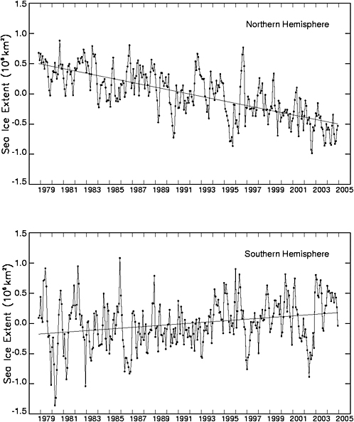
FIGURE 9.7 Deviations in monthly sea ice extent in the Northern and Southern Hemispheres from November 1978 through December 2004, derived from satellite passive-microwave observations. The Arctic sea-ice decreases are statistically significant, with a trend-line slope of −38,200 ±2,000 km2/yr, and have contributed to much concern about the warming Arctic climate and the potential effects on the Arctic ecosystem. The Antarctic sea-ice increases are also statistically significant, although at a much lower rate of +13,600 ±2,900 km2/yr. The Northern Hemisphere plot is extended from Parkinson et al. (1999), and the Southern Hemisphere plot is extended from Zwally et al. (2002).
The panel proposes a mission aimed explicitly at ice dynamics, specifically a C-band left-right-looking interferometric synthetic aperture radar (InSAR) to be flown in polar orbit and with orbit maintenance and satellite navigation sufficient for SAR interferometry. The orbit repeat should be short enough to achieve coherence between repeat-pass observations but long enough to ensure total geographic coverage. C-band is selected on the basis of heritage of highly successful measurements made with the ERS-1/2, RADARSAT, and Envisat SARs over ice. Lower-frequency systems, such as L-band as used on the Japanese ALOS, are also likely to provide important image and interferometric data for cryospheric research. However, deeper penetration of the signal into the low-loss upper portions of the ice sheet will be a challenge for L-band instruments because of the consequent decrease in coherence, which is already low for many parts of Antarctica even at C-band. That challenge can potentially be addressed by stringent requirements on orbit repeat cycles and repeat orbit baselines.
RFI responses relevant to this proposed mission include those from the InSAR Steering Group (“InSAR Applications for Exploration of the Earth”) and Andrew Gerber (“Operational Ocean and Land Mission”). InSAR will provide observations of ice sheet surface velocity, which, through the ice flow law, will yield estimates of the stresses acting on the ice sheet. Such information is critically important for understanding the forces controlling ice sheet flow (side drag versus basal drag on ice streams, for example) and for predicting changes in ice sheet flow due to changes in climate (for example, motion acceleration driven by increasing surface-melt water drainage, which leads to greater lubrication at the glacier bed in the marginal regions of the Greenland ice sheet). That is precisely the information most necessary for understanding ice sheet processes sufficiently to capture their behavior in global climate models.
SAR as an imaging tool also provides information on the sea ice deformation field; and some analysis suggests that SAR data might be useful for updating algorithms of sea ice concentration and extent. Furthermore, in addition to its value for ice sheet dynamics and sea ice, an InSAR instrument, with a suitable choice of operating frequencies, would have substantial benefits for the solid-Earth and natural-hazards communities (see Chapters 5 and 8).
The InSAR mission would be greatly strengthened by coordination with or the addition of other missions. Two are particularly relevant:
-
Ideally, InSAR should be flown in coordination with Climate Mission 1 (Clouds, Aerosols, and Ice) or other spacecraft carrying laser or radar altimeters for snow- or ice-surface elevation. The altimeter provides highly accurate topographic measurements along narrow swaths, and the InSAR can provided coarser estimates of topography in two dimensions.
-
InSAR measurements of ice motion and topography combined with highly accurate elevations from Climate Mission 1 (Clouds, Aerosols, and Ice) and with gravity measurements from a GRACE-type mission would yield much improved estimates of changes in ice sheet mass balance. The combination of measurements of ice-sheet motion, topography, and mass would yield a powerful tool for assessing changes in the ice sheets. GRACE also has important applications for the oceanographic and hydrologic communities. A GRACE type of follow-on mission should be seriously considered as a component of Climate Mission 3.
Box 9.3 summarizes the components of the panel’s proposed Climate Mission 3.
|
BOX 9.3 CLIMATE MISSION 3 COMPONENTS TABLE 9.3.1 Science and Application Capabilities
TABLE 9.3.2 Instruments and Science Objectives
TABLE 9.3.3 Instrument Requirements
|
Climate Mission 4: Measuring Ocean Circulation, Ocean Heat Storage, and Ocean Climate Forcing
Mission Summary Ocean Circulation, Heat Storage, and Climate Forcing
|
Variables: |
Surface-ocean circulation, bottom topography, ocean-atmosphere interaction, sea level |
|
Sensors: |
Swath radar altimeter, scatterometer |
|
Orbit/coverage: |
LEO/global |
|
Panel synergies: |
Solid Earth, Water, Weather |
Ocean altimetry measurements monitor changes in sea level. Changes in mean sea level have several components, of which the two major ones are thermal expansion of a warming ocean and transfer of land ice to the oceans (from melting, calving, or ice flow into ice shelves). Measuring the former is of extreme importance because it is a sensitive measure of how rapidly heat is being mixed into the ocean and is a key factor in the rate of global warming. Altimetric measurements can improve knowledge of heat uptake (Willis et al., 2004) by supplementing measurements of the ocean temperatures heretofore measurable only by ships or buoys (not just sea-surface temperature that is measurable by satellite). Indeed the recent analysis of Forest et al. (2006) suggests that the current climate models are overestimating heat uptake. Combining altimetry with the mass measurements of a GRACE instrument allows the separation of the thermal and freshwater-ice components of sea-level rise. On a finer scale, the gradients of the measured difference between surface topography and the geoid are a measure of circulation at the surface of the ocean. For example, Goni and Trinanes (2003) showed that hurricanes gain energy as they pass over the Gulf of Mexico Loop Current and that the position of the Loop Current can be effectively tracked from multialtimeter measurements of sea-level elevation (Figure 9.8). This information can be used to improve forecasts of hurricane strength and thus can save lives.
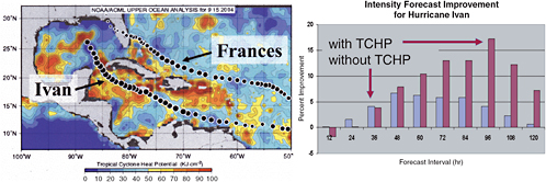
FIGURE 9.8 Use of altimetric sea-surface height,calibrated to upper-ocean heat content or “hurricane potential,” would have provided 17 percent improvement in the 96-hour forecast of Hurricane Ivan’s intensity. The map and plot show the tropical cyclone heat-potential field (TCHP; upper-ocean heat content from the sea surface to the depth of the 26°C isotherm) estimated by using altimeter-derived sea-height anomalies, sea-surface temperature, and climatology of the temperature and salinity fields within a two-layer reduced gravity approximation. SOURCE: Courtesy of G.Goni and M.DeMaria, NOAA.
Ocean surface topography has been measured continuously since 1992 with nadir-pointing altimeters operated by NASA and CNES (TOPEX/Poseidon, Jason) and by the European Space Agency (ERS-1, ERS-2, and Envisat). Climate Mission 4 is proposed as a 5-year satellite mission using a wide-swath radar altimeter to measure ocean surface topography globally (or at least throughout the non-ice-covered oceans, depending on the selected orbit; see discussion below) with minimal or no spatial gaps. The wide-swath technology is capable of both continuing the climatically important sea-level elevation time series in a consistent manner and mapping mesoscale eddies globally every few days. A wide-swath altimeter was originally planned as part of the Jason-2 altimeter, and revival of a wide swath was endorsed in the decadal survey committee’s interim report (NRC, 2005c). Wide-swath technology has undergone considerable development (Fu and Rodriguez, 2004), and the design now under discussion (“Hydrosphere Mapper” RFI response; “WatER” RFI response) provides high-resolution spatial coverage throughout the swath. It will fulfill the panel’s vision both by offering an extension of the existing long-term altimetric time series of global sea level and by providing essential observations to allow study of the role of eddies in upper-ocean processes.
NASA (United States) and CNES (France) jointly fly one radar altimeter, Jason, and have plans for a follow-on mission. ESA flies a second altimeter on Envisat in a different orbit and has plans for a continued program. The U.S. Navy runs a third altimeter, GFO. France and India have also announced plans to launch an altimeter. Measurements from those instruments are mapped jointly to provide a best estimate of sea level. Nevertheless, many oceanic features, such as eddies and the warm ocean currents that amplify hurricanes, cannot be seen without a wide-swath altimeter. Laser altimeters do not meet the oceanographic requirements, because they do not provide data in cloudy regions. No space program has current plans for a wide-swath radar altimeter, and such measurements are needed to quantify the ocean’s role in climate change.
Climate Mission 4 with wide-swath altimetry would substantially augment the current and planned ocean satellite missions. It alone can provide a detailed picture of mesoscale circulation that can be used to improve understanding of the physics governing ocean circulation and of the interactions between the ocean and the atmosphere. The improved understanding will lay the groundwork for improvements in predictive climate models and will serve as a benchmark record of current ocean circulation against which future changes in ocean circulation can be judged.
Wide-swath altimeter programs have potential payoffs outside the purview of the Climate Change and Variability Panel for both hydrologic and geophysical applications. The hydrologic community has identified wide-swath altimetry as a means to monitor lake and river levels on a regular basis, particularly at high latitudes. To the extent that the global hydrologic cycle is part of the climate system, that would have clear payoffs for climate research. The geophysical community has advocated high-precision wide-swath altimetry as a means to measure the high-wave-number geoid gradient, which provides a measure of seafloor bathymetry and correspondingly, of bottom roughness. The information also has potential climate benefits in that it will improve the representations of the bottom boundary condition and of topography-driven mixing processes in ocean general-circulation models.
Different potential users of a wide-swath altimeter have advocated different orbit requirements. Oceanographic users prefer an orbit that is not Sun-synchronous and that is optimized to avoid aliasing any of the major tidal constituents into low frequencies. Geophysical users favor an orbit that provides complete global coverage in ice-free regions, with no requirement for repeat tracks (see “ABYSS-Lite” RFI response). Hydrologic users advocate an 8-day sampling interval to be achieved with a 16-day repeat orbit; although they have proposed a Sun-synchronous satellite to reduce mission costs, the choice of a Sun-synchronous orbit is not critical for the hydrologic science objectives (see “WatER” RFI response). To select an orbit that best satisfies all user requirements, NASA needs to assess the design requirements for a non-Sun-synchronous orbit and to evaluate tidal aliasing patterns associated with possible orbits.
Wide-swath altimeter measurements would be enhanced if the data were coincident with measurements from a gravity mission (“GRACE Follow-on” RFI response). An altimeter alone measures sea-surface height anomalies associated with geostrophic flows in the ocean, but it cannot detect mean absolute dynamic topography associated with the mean geostrophic circulation. Independent gravity data provide a large-scale geoid, allowing absolute geostrophic velocities to be determined. A gravity mission tracks time-varying changes in ocean mass that are also useful for identifying whether sea-level changes are due to ice melt, thermal expansion of the ocean, or mass displacements within the ocean.
Because the upper ocean circulation is wind-driven, Climate Mission 4 includes coincident global high-accuracy measurements of ocean vector winds daily or twice a day. Long-term plans in the United States have focused on passive microwave wind measurements that have not been able to provide accurate wind estimates at high or low speeds. Wind forcing can be estimated by active microwave measurements of sea-surface roughness. Active scatterometry measurements have been made on and off since the launch of ERS-1 in 1992. The United States now flies one scatterometer, QuikSCAT, which is roughly able to meet the data-coverage requirement. ESA recently launched ASCAT, which has a relatively narrow field of view that will not fully capture high-frequency temporal variability in the winds that drive the ocean circulation. There are no plans to ensure coincident wind and sea-surface height measurements.
At this stage, the combination of a wide-swath altimeter and complementary scatterometer would provide a research mission with immediate payoffs by advancing understanding of the physics driving the upper ocean. Those payoffs could well lead to advances in the representation of upper-ocean processes in climate models as well as better ENSO forecasts. Scientific users will probably request continuous measurements as an operational program, assuming that the wide-swath mission meets its objectives.
Box 9.4 summarizes the components of the panel’s proposed Climate Mission 4.
High-Priority Subjects Requiring Innovative Approaches
Some of the major issues in climate research require innovative measurement approaches beyond those proposed in the RFI responses and beyond those required for Climate Missions 1–4. Focus areas Alpha and Beta are designed to highlight new satellite observations and approaches with the potential to greatly expand knowledge of the climate system, test key climate processes in the models, and improve the ability to forecast climate variability and climate change. Because of the extent to which these missions require innovative thinking and investment in new technologies, specific instruments and plans are not included.
Focus Area Alpha: Measurement of Surface Fluxes
Climate prediction depends on understanding the exchanges of heat, water, gases, and momentum between the ocean, atmosphere, land, and cryosphere. Those exchange fluxes are currently measured at heavily instrumented surface sites. They are not readily measured from space. Without space-based observations, there is no global perspective on spatial and temporal variations in air-sea and land-atmosphere fluxes, and information needed for reliable climate predictions is thus lacking.
Improving surface flux estimates is difficult. Many RFI responses mentioned fluxes, but none had a primary objective of obtaining improved surface flux measurements, probably because no simple suite of space-borne instruments will provide direct measurements of all desired surface fluxes. NASA, NOAA, and other agencies should pursue a multistep approach to improve knowledge of surface fluxes. This may include a broad array of activities, such as evaluating existing observations, improving data-assimilation schemes, expanding the surface-based observing system, and developing new satellite sensors.
|
BOX 9.4 CLIMATE MISSION 4 COMPONENTS TABLE 9.4.1 Science and Applications Capabilities
TABLE 9.4.2 Instruments and Science Objectives
TABLE 9.4.3 Instrument Requirements
|
Different surface fluxes have different measurement requirements. For example, current research (Curry et al., 2004) shows that the air-sea flux of sensible heat can be approximated (parameterized) as a function of surface wind, sea-surface temperature, and near-surface air temperature. Thus, a potential satellite mission might combine active microwave scatterometer winds, passive microwave sea-surface temperature, and boundary-layer atmospheric temperatures. Latent heat fluxes would require the same quantities as sensible heat fluxes and an estimate of boundary-layer humidity. Detecting small differences in temperature between the surface and the lower atmosphere is challenging and likely to test the capabilities of atmospheric sounders. Moreover, bulk parameterizations may not be accurate, and the satellite mission might have to find a more direct measurement of the fluxes. Some progress is being made along these lines for momentum fluxes, with scatterometer winds, but no obvious strategies exist for other surface fluxes.
Not all flux-related variables may be measurable from space at present. However, current technology does allow satellite measurement of many key parameters such as winds, sea-surface temperatures, salinity, soil moisture, atmospheric water vapor, and rain. Thus, the panel recommends a detailed study of whether parameter-based flux measurements using current or anticipated technologies would provide the accuracy needed for air-sea or air-land fluxes. The technological challenges involved in detecting fluxes from space should not justify inaction.
Focus Area Beta: Measurement of Convective Transports
Atmospheric convection is a key process in climate models that is not well understood. Convection transports heat, water vapor, momentum, trace gases, and aerosols in the presence of clouds and mixed phases of precipitation. It links the near-surface boundary layer with the upper reaches of the troposphere and controls the stratosphere-troposphere exchange of gases.
Convection is a fundamental process that is treated only approximately in climate models as a vertical redistribution of heat, momentum, and water vapor. Changes in upper tropospheric water vapor constitute a prime feedback in a warming climate, and thus understanding how convection controls the distribution of water vapor will advance climate modeling. Convective transport is complex, involving both upward and downward fluxes in the same air column. The scale of those motions and their coincidence with clouds makes direct measurement of air-mass or tracer-mass fluxes from space impractical. The interaction of clouds and precipitation with soluble species or trapped aerosols makes convective transport generally nonconservative. Improved modeling of convection is one of the key advances needed for regional climate predictions.
Trace Gases and Aerosols
Improved knowledge of the effects of convection is needed both for predicting the abundance of greenhouse gases and other pollutants and for identifying primary emissions. The rate of vertical mixing in the atmosphere controls the abundance and impact of many short-lived and reactive chemical species—both gases and aerosols. The photochemical environment of the boundary layer, where most such species are emitted, is very different from that of the free troposphere. For example, pollutants trapped in the boundary layer are often chemically processed and scavenged from the atmosphere near their sources, whereas the same species once lofted into the free troposphere can travel around the globe generating intercontinental pollution. Even for gases with little chemical reactivity, such as CO2 and 85Kr, the rate of vertical mixing in the atmosphere controls the gradients between surface sources and the remote atmosphere, and these gradients are used to infer the location and magnitude of sources. Important vertical transports occur both through large-scale adiabatic lifting motions (reasonably well represented in models) and through convective motions, including clouds and turbulence, which are not well understood or well represented in atmospheric tracer transport.
Stratosphere-Troposphere Exchange
The balance between convection and radiation controls the tropical tropopause region and thus plays a major role in stratosphere-troposphere exchange, particularly with respect to the abundances of water vapor, aerosols, and halogen compounds entering the stratosphere in the tropics. Convection also contributes to erosion of the midlatitude tropopause in spring and the ensuing flux of ozone into the troposphere from above. One objective is to measure atmospheric composition through the upper troposphere and across the tropopause to help to understand the atmospheric regions and processes involved in stratosphere-troposphere exchange.
Observations are needed to characterize the convective event (e.g., to enable the derivatives of the large-scale convergence of heat and water vapor, cloud base and top, and precipitation) and to measure the redistribution of trace species, including water isotopes, to derive the net convective transports. For example, missions might be designed to accumulate the statistics of convection, building up the patterns of trace species before and after convective transport with the magnitude and type of convective transport. Measurements taken during the airborne CRYSTAL-FACE experiments are able to follow specific events, measure the altitude of convective outflow along with the abundance of boundary-layer tracers, and obtain needed measurements.
A mission focused on convection cannot now be assembled from known instruments (or directly from RFI responses). However, the components might include a limb-scanning instrument with high vertical resolution (1 km) and sensitivity to trace species and water isotopes; a lidar or similar measurement of boundary-layer pollutants, such as CO or aerosols; cloud measurements and imager; and a precipitation measure. Given the diurnal cycles in convection and rainfall, the observations cannot be made usefully from a Sun-synchronous orbit. The most important convective transports occur in the tropics or midlatitudes and could be served by a diurnally shifting low-inclination low-Earth-orbit mission like TRMM. Furthermore, these measurements would be greatly enhanced by a cloud-aerosol mission (such as Climate Mission 1). The auxiliary use of a GEO pollution or storm mapper might help to fill in the full cycle of convection. As noted earlier, some intensive in situ campaigns are required to more fully understand the convective cycle.
OTHER SPECIAL ISSUES
The spaced-based measurements of the Earth system that will be collected in the next two decades will provide scientists with a unique opportunity to gauge climate trends in terms of both the mean state of the system and its variability, including the probability of extreme events (Climate Missions 1–4). The possibility of investigating processes (focus areas Alpha and Beta) that can improve modeling efforts has the potential to advance climate forecasts substantially and to produce models that will be ever more useful for regional impact studies.
However, providing the type of information necessary for detection of climate variability and change requires coordination of instruments, missions, and analysis programs. The realization of the program also depends on interagency collaboration and international cooperation. The transition of science-driven missions to operational missions presents challenges related to the integrity of the scientific data. The problems of data continuity, relative and absolute calibration of the measurement sequence, open access to and availability of data, standardization of processing, and distribution standards must all be considered.
Interagency Issues
A number of institutional challenges must be addressed to achieve the full potential of the climate missions outlined above. It is necessary to identify clearly the respective roles of NASA, NOAA, NSF, DOE, DOD, and other agencies in advancing sensor technology, system calibration and validation, and data archiving and management.
NOAA’s plans for data calibration after the NPOESS Preparatory Project (NPP) fall short of those required for climate studies because of budgetary constraints and institutional culture. Other issues related to transparency of processing methods are of concern. Given the national commitment to NPOESS and current problems with it as a suitable and cost-effective platform for climate studies, NOAA, NASA, and other agencies with climate interests should actively participate in a plan to ensure adequate long-term, high-quality data sets on climate. A number of recommendations related to those issues can be found
in previous NRC reports (e.g., NRC, 2000a,b,c). For NOAA to realize its mandate as the federal agency charged with collecting and managing space-based observations of climate it must have funding to acquire the infrastructure and workforce and must embrace a culture in which climate has high priority. That will require a plan whereby research and operations responsibilities are integrated to balance technical innovation, data quality and stability, and flexibility to meet emerging science questions and concerns.
International Partnerships
International partnering on instrument development, satellite operations, data exchange, and data analysis spreads the cost burden, mitigates risks of gaps in particular data streams, encourages technical innovation by broadening the engineering expertise base, and increases the number of science users. NASA and its international partners have enjoyed those benefits through numerous programs—including joint ventures on EOS, TOPEX/Poseidon, and RADARSAT-1—and more generally through programs such as the International Global Observing System, the International Polar Year, and CLIVAR. Moreover, it is now relatively common for flight agencies to offer announcements of opportunity to the international science community as the agencies attempt to maximize the payoff of each flight project.
The potential advantages of collaborations are obvious, but realizing the advantages can be complicated by a number of factors. Instruments built by one partner may not be designed to the exact requirements of another partner, and technology-transfer restrictions may prevent the exchange of important technical details about the instruments. Restrictions on access to data and software vary from country to country, as do approaches to calibration and validation. Joint ventures between government flight agencies and commercial partners can result in serious complications with data cost, availability, and distribution. With that in mind, international partnerships should be fostered only where synergy between instrument capabilities and science requirements is strong, where there is free and easy access to data, and where there is transparency in the process of analyzing data so that analysis algorithms are freely available.
Improving Climate Modeling Through the Application of New Satellite Measurements
Interaction between the climate modeling and satellite remote-sensing communities is too limited (NRC, 2001c). Existing data sets are underused by the climate-modeling community. The CLIVAR Climate Process Teams Program for in situ measurements is designed specifically to understand processes poorly handled by the climate models and provides a framework that could be adopted for a similar effort involving satellite measurements. The panel recommends a new cross-agency effort to foster a more fertile crossover between those collecting, managing, and analyzing satellite observations and the modeling groups. Such a program must be well managed and funded. Success will require improved, coincident in situ observations such as those traditionally carried out by DOE, DOD, NSF, and other agencies, but these should be augmented to include dedicated field programs that address specific scientific questions related to the proposed missions.
Workforce
A successful and robust plan for improving climate prediction must include the education of the workforce, including the engineers who design sensor systems and the geoscientists who interpret data. A close interaction between those groups to assess evolving needs is essential. A concerted effort should be made to fund universities and national laboratories for training graduate students and postdoctoral researchers for this purpose.
Data Management and Distribution
A successful climate science program will require a robust data system for satellite measurements as outlined in previous NRC reports (NRC, 2000a, 2004, 2005a). In particular, computer systems must be designed to facilitate reprocessing, archiving, and distribution of NPOESS data. Many of the recommendations made in an NRC report on climate data records (NRC, 2004) apply to satellite-based observation. Three points deserve particular attention: there should be easy access to data; metadata should be available to document sensor performance history and data-processing algorithms and to allow reprocessing to adjust for bias, drift, and other errors in the datasets; and representatives of various components of the climate community should be actively involved in data generation and stewardship decisions. Those procedures will enhance and expand data access by researchers and climate service providers and foster the development of value-added products for the climate services discussed earlier.
BIBLIOGRAPHY
Ackerman, A., O.B.Toon, D.E.Stevens, A.J.Heymsfield, V.Ramanathan, and E.J.Welton. 2000. Reduction of tropical cloudiness by soot. Science 288:1042–1047.
Albrecht, B.A. 1989. Aerosols, cloud microphysics, and fractional cloudiness. Science 245:1227–1230.
Anderson, J.G., J.A.Dykema, R.M.Goody, H.Hu, and D.B.Kirk-Davidoff. 2004. Absolutely, spectrally-resolved, thermal radiance: A benchmark for climate monitoring from space. J. Quant. Spectrosc. Radiat. Transfer 85:367–383.
Andreae, M.O., C.D.Jones, and P.M.Cox. 2005. Strong present-day aerosol cooling implies a hot future. Nature 435(7046):1187– 1190, doi:10.1038/nature03671.
Behrenfeld, M., J.T.Randerson, C.R.McClain, G.C.Feldman, S.O.Los, C.J.Tucker, P.G.Falkowski, C.B.Field, R.Frouin, W.E.Esaias, D.D.Kolber, and N.H.Pollack. 2001. Biospheric primary production during an ENSO transition. Science 291:2594–2597.
Behrenfeld, M., E.Boss, D.A.Siegel, and D.M.Shea. 2005. Carbon-based ocean productivity and phytoplankton physiology from space. Global Biogeochem. Cy. 19:GB1006, doi:10.1029/2004GB002299.
Bengtsson, L., G.Robinson, R.Anthes, K.Aonashi, A.Dodson, G.Elgered, G.Gendt, R.Gurney, M.Jietai, C.Mitchell, M.Mlaki, A. Rhodin, P.Silvestrin, R.Ware, R.Watson, and W.Wergen. 2003. The use of GPS measurements for water vapor determination. B. Am. Meteorol. Soc. 84:1249–1258.
Breon, F.M., and P.Goloub. 1998. Cloud droplet effective radius from spaceborne polarization measurements. Geophys. Res. Let. 25:1879–1882.
Breon, F.M., J.C.Buriez, P.Couvert, P.Y.Deschamps, J.L.Deuze, M.Herman, P.Goloub, M.Leroy, A.Lifermann, C.Moulin, F. Parol, G.Seze, D.Tanre, C.Vanbauce, and M.Vesperini. 2002. Scientific results from the Polarization and Directionality of the Earth’s Reflectances (POLDER). Adv. Space Res. 30(11):2383–2386.
CCSP (Climate Change Science Program). 2003. Strategic Plan for the U.S. Climate Change Science Program. CCSP, Washington, D.C. Available at http://www.climatescience.gov/Library/stratplan2003/final/ccspstratplan2003-all.pdf.
Curry, J.A., A.Bentamy, M.A.Bourassa, D.Bourras, E.F.Bradley, M.Brunke, S.Castro, S.H.Chou, C.A.Clayson, W.J.Emery, L. Eymard, C.W.Fairall, M.Kubota, B.Lin, W.Perrie, R.A.Reeder, I.A.Renfrew, W.B.Rossow, J.Schulz, S.R.Smith, P.J.Webster, G.A.Wick, X.Zeng. 2004. SEAFLUX. B. Am. Meteorol. Soc. 85:409–424.
Dubayah, R., J.B.Blair, J.L.Bufton, D.B.Clark, J.Jájá, R.Knox, S.B.Luthcke, S.Prince, and J.Weishampel. 1997. The Vegetation Canopy Lidar Mission. Pp. 100–112 in Land Satellite Information in the Next Decade II: Sources and Applications. ASPRS, Washington, D.C.
Ekstrom, G., M.Nettles, and V.C.Tsai. 2006. Seasonality and increasing frequency of Greenland glacial earthquakes. Science 311:1756.
Eyring, V., N.R.P.Harris, M.Rex, T.G.Sheperd, D.W.Fahey, G.T.Amanatidis, J.Austin, M.P.Chipperfield, M.Dameris, P.M.de F. Forster, A.Gettleman, H.F.Graf, T.Nagashima, P.A.Newman, S.Pawson, M.J.Prather, J.A.Pyle, R.J.Salawitch, B.Santer, and D.W.Waugh. 2005. A strategy for process-oriented validation of coupled chemistry-climate models. B. Am. Meteorol. Soc. 86(8):1117–1133.
Forest, C.E., P.H.Stone, and A.P.Solokov. 2006. Estimated PDF of climate system properties including natural and anthropogenic forcings. Geophys. Res. Lett. 33:L01705, doi:10.1029/2005GL023977.
Fu, L-L., and E.R.Rodriguez. 2004. High-resolution measurement of ocean surface topography by radar interferometry for oceanographic and geophysical applications. Pp. 209–224 in State of the Planet: Frontiers and Challenges, AGU Geophysical Monograph 150, IUGG Vol. 19 (R.S.J.Sparks and C.J.Hawkesworth, eds.). American Geophysical Union, Washington, D.C.
GCOS (Global Climate Observing System). 2003. The second report on the adequacy of the global observing systems for climate in support of the UNFCCC. GCOS-82, WMO Tech. Doc. 1143.
Goni, G., and J.Trinanes. 2003. Ocean thermal structure monitoring could aid in the intensity forecast of tropical cyclones. EOS 84:573–580.
Goody, R., J.Anderson, and G.North. 1998. Testing climate models: An approach. B. Am. Meteorol. Soc. 79:2541–2549.
Hansen, J., and M.Sato. 2001. Trends of measured climate forcing agents. Proc. Natl. Acad. Sci. U.S.A. 98:14778–14783.
Haywood, J., and O.Boucher. 2000. Estimates of the direct and indirect radiative forcing due to tropospheric aerosol: A review. Rev. Geophys. 38:513–543.
IPCC (Intergovernmental Panel on Climate Change). 2001. Climate Change 2001: Impacts, Adaptation and Vulnerability. Cambridge University Press, Cambridge, U.K.
Jacobson, M.Z. 2001. Strong radiative heating due to the mixing of black carbon in atmospheric aerosol. Nature 409:695–697.
Kahn, R., P.Banerjee, D.McDonald, and J.Martonchik. 2001. Aerosol properties derived from aircraft multi-angle imaging over Monterey Bay. J. Geophys. Res. 106:11977–11995.
Kaufman, Y.J., and I.Koren. 2006. Smoke and pollution aerosol effect on cloud cover. Science 313(5787):655–658.
Kaufman, Y.J., D.Tanre, and O.Boucher. 2002a. A satellite view of aerosols in the climate system. Nature 419:215–223.
Kaufman, Y.J., J.V.Martins, L.A.Remer, M.R. Schoeberl, and M.A. Yamasoe. 2002b. Satellite retrieval of aerosol absorption over the oceans using sunglint. Geophys. Res. Lett. 29(19):1928, doi:10.1029/2002GL015403.
Kaufman, Y.J., I.Koren, L.A.Remer, D.Rosenfeld, and Y.Rudich. 2005. The effect of smoke, dust and pollution aerosol on shallow cloud development over the Atlantic Ocean. Proc. Natl. Acad. Sci. U.S.A. 102(32):11207–11212.
Keith, D.W., and J.G.Anderson. 2001. Accurate spectrally resolved infrared radiance observation from space: Implications for the detection of decade to century-scale climate change. J. Climate 14:979–990.
Kirk-Davidoff, D.B., R.M.Goody, and J.G.Anderson. 2005. Analysis of sampling errors for climate monitoring satellites. J. Climate 18:810–822.
Koren, I., Y.J.Kaufman, L.A.Remer, and J.V.Martins. 2004. Measurement of the effect of Amazon smoke on inhibition of cloud formation. Science 303:1342–1345.
Koren, I., Y.J.Kaufman, D.Rosenfeld, L.A.Remer, and Y.Rudich. 2005. Aerosol invigoration and restructuring of Atlantic convective clouds. Geophys. Res. Lett. 32:L14828, doi:10.1029/2005GL023187.
Loeb, N.G., and N.Manalo-Smith. 2005. Top-of-atmosphere direct radiative effect of aerosols over global oceans from merged CERES and MODIS observations. J. Climate 18:3506–3526.
Loeb, N.G., N.Manalo-Smith, W.F.Miller, S.K.Gupta, P.Minnis, and B.A.Wielicki. 2003a. Angular distribution models for top-of-atmosphere radiative flux estimation from the Clouds and the Earth’s Radiant Energy System instrument on the Tropical Rainfall Measuring Mission Satellite. Part 1: Methodology. J. Appl. Meteor. 42:240–265.
Loeb, N.G., L.Konstantin, N.Manalo-Smith, B.A.Wielicki, and D.F.Young. 2003b. Angular distribution models for top-of-atmosphere radiative flux estimation from the Clouds and the Earth’s Radiant Energy System Instrument on the Tropical Rainfall Measuring Mission Satellite. Part II: Validation. J. Appl. Meteor. 42:1748–1769.
Loeb, N.G., S.Kato, K.Loukachine, and N.Manalo-Smith. 2005. Angular distribution models for top-of-atmosphere radiative flux estimation from the Clouds and the Earth’s Radiant Energy System instrument on the Terra Satellite. Part 1: Methodology. J. Atmos. Oceanic Technol. 22:338–351.
Loeb, N.G., B.A.Wielicki, F.G.Rose, and D.R.Doelling. 2007. Variability in global top-of-atmosphere shortwave radiation between 2000 and 2005. Geophys. Res. Lett. 34:L03704, doi:10.1029/2006GL028196.
Luthcke, S.B., H.J.Zwally, W.Abdalati, D.D.Rowlands, R.D.Ray, R.S.Nerem, F.G.Lemoine, J.J.McCarthy, and D.S.Chinn. 2006. Recent Greenland ice mass loss by drainage system from satellite gravity observations. Science 314:1286–1289, published online October 18, 2006, doi:10.1126/science.1130776.
NASA (National Aeronautics and Space Administration). 2005. Arctic sea ice continues to decline, Arctic temperatures continue to rise in 2005. NASA Goddard Space Flight Center News, September 28. Available at http://www.nasa.gov/centers/goddard/news/topstory/2005/arcticice_decline.html.
National Assessment Synthesis Team, ed. 2000. Climate Change Impacts on the United States: Overview. Cambridge University Press, Cambridge, U.K.
NRC (National Research Council). 1985. A Strategy for Earth Science from Space in the 1980’s and 1990’s—Part II: Atmosphere and Interactions with the Solid Earth, Oceans, and Biota. National Academy Press, Washington, D.C.
NRC. 1994. GOALS (Global Ocean-Atmosphere-Land System) for Predicting Seasonal-to-Interannual Climate: A Program of Observation, Modeling, and Analysis. National Academy Press, Washington, D.C.
NRC. 1998a. The Atmospheric Sciences: Entering the Twenty-First Century. National Academy Press, Washington, D.C.
NRC. 1998b. Capacity of U.S. Climate Modeling to Support Climate Change Assessment Activities. National Academy Press, Washington, D.C.
NRC. 1999a. Adequacy of Climate Observing Systems. National Academy Press, Washington, D.C.
NRC. 1999b. Global Environmental Change: Research Pathways for the Next Decade. National Academy Press, Washington, D.C.
NRC. 1999c. Making Climate Forecasts Matter. National Academy Press, Washington, D.C.
NRC. 1999d. Our Common Journey: A Transition Toward Sustainability. National Academy Press, Washington, D.C.
NRC. 2000a. From Research to Operations in Weather Satellites and Numerical Prediction: Crossing the Valley of Death. National Academy Press, Washington, D.C.
NRC. 2000b. Issues in the Integration of Research and Operational Satellite Systems for Climate Research: Part L Science and Design. National Academy Press, Washington, D.C.
NRC. 2000c. Issues in the Integration of Research and Operational Satellite Systems for Climate Research: Part II. Implementation. National Academy Press, Washington, D.C.
NRC. 2001a. Improving the Effectiveness of U.S. Climate Modeling. National Academy Press, Washington, D.C.
NRC. 2001b. Climate Change Science: An Analysis of Some Key Questions. National Academy Press, Washington, D.C.
NRC. 2001c. The Science of Regional and Global Change: Putting Knowledge to Work. National Academy Press, Washington, D.C.
NRC. 2001d. A Climate Services Vision: First Steps Toward the Future. National Academy Press, Washington, D.C.
NRC. 2002. Abrupt Climate Change: Inevitable Surprises. National Academy Press, Washington, D.C.
NRC. 2003a. Satellite Observations of the Earth’s Environment: Accelerating the Transition of Research to Operations. The National Academies Press, Washington, D.C.
NRC. 2003b. Understanding Climate Change Feedbacks. The National Academies Press, Washington, D.C.
NRC. 2003c. Estimating Climate Sensitivity. The National Academies Press, Washington, D.C.
NRC. 2004. Climate Data Records from Environmental Satellites. The National Academies Press, Washington, D.C.
NRC. 2005a. Review of NOAA’s Plan for the Scientific Data Stewardship Program. The National Academies Press, Washington, D.C.
NRC. 2005b. Radiative Forcing of Climate Change: Expanding the Concept and Addressing Uncertainties. The National Academies Press, Washington, D.C.
NRC. 2005c. Earth Sciences and Applications from Space: Urgent Needs and Opportunities to Serve the Nation. The National Academies Press, Washington, D.C.
Ohring, G., B.Wielicki, R.Spencer, B.Emery, R.Datla. 2005. Satellite instrument calibration for measuring global climate change: Report of a workshop. B. Am. Meteorol. Soc. 86:1303–1306.
Parkinson, C.L. 2006. Earth’s cryosphere: Current state and recent changes. Annu. Rev. Env. Resour. 31:33–60.
Parkinson, C.L., D.J.Cavalieri, P.Gloersen, H.J.Zwally, and J.C.Comiso. 1999. Arctic sea ice extents, areas, and trends, 1978–1996. J. Geophys. Res. 104(C9):20837–20856.
Plattner, G., F.Joos, and T.F.Stocker. 2002. Revision of the global carbon budget due to changing air-sea oxygen fluxes. Global Biogeochem. Cy. 16(4):1096, doi:10.1029/2001GB001746.
Potter, G.L., and R.D.Cess. 2004. Testing the impact of clouds on the radiation budgets of 19 atmospheric general circulation models. J. Geophys. Res. 109(D2):D02106, doi:10.1029/2003JD004018.
Rignot, E., and P.Kanagaratnam. 2006. Changes in the velocity structure of the Greenland ice sheet. Science 311:986.
Santer, B.D., R.Sausen, T.M.L.Wigley, J.S.Boyle, K.AchutaRao, C.Doutriaux, J.E.Hansen, G.A.Meehl, E.Roeckner, R.Ruedy, G. Schmidt, and K.E.Taylor. 2003. Behavior of tropopause height and atmospheric temperature in models, reanalyses, and observations: Decadal changes. J. Geophys. Res. 108(D1):4002, doi:10.1029/2002JD002258.
Satheesh, S.K., and V.Ramanathan. 2000. Large differences in tropical aerosol forcing at the top of the atmosphere and Earth’s surface. Nature 405:60–63.
Sundquist, E.T. 1993. The global carbon dioxide budget. Science 259:934–941.
Tegen, I., D.Koch, A.A.Lacis, M. Sato. 2000. Trends in tropospheric aerosol loads and corresponding impact on direct radiative forcing between 1950 and 1990: A model study. J. Geoph. Res. 105:26971–26989.
Torres O., P.K.Bhartia, J.R.Herman, and Z.Ahmad. 1998. Derivation of aerosol properties from satellite measurements of backscattered ultraviolet radiation: Theoretical basis. J. Geophys. Res. 103:17099–17110.
Trenberth, K., B.Moore, T.Karl, and C.Nobre. 2006. Monitoring and prediction of the Earth’s climate: A future perspective. J. Climate 19:5001–5008.
Twomey, S.A. 1977. The influence of pollution on the shortwave albedo of clouds. J. Atmos. Sci 34:1149–1152.
Wanninkhof, R., and W.R.McGillis. 1999. A cubic relationship between air-sea CO2 exchange coefficient and wind speed. Geophys. Res. Lett 26(13):1889–1892.
Wielicki, B.A., T.Wong, R.P.Allan, A.Slingo, J.T.Kiehl, B.J.Soden, C.T.Gordon, A.J.Miller, S.-K.Yang, D.A.Randal, F.Robertson, J.Susskind, and H.Jacobowitz. 2002. Evidence for large decadal variability in the tropical mean radiative energy budget. Science 295:841–844.
Willis, J., D.Roemmich, and B.Cornuelle. 2004. Interannual variability of upper ocean heat content, temperature and thermosteric expansion on global scales. J. Geophys. Res. 109:C12036, doi:10.1029/2003JC002260.
Wong, T., B.A.Wielicki, R.E.Lee III, G.L.Smith, K.A.Bush, and J.K.Willis. 2006. Re-examination of the observed decadal variability of Earth radiation budget using altitude-corrected ERBE/ERBS nonscanner WFOV data. J. Climate 19:4028–4040.
Yu, Y., G.A.Maykut, and D.A.Rothrock. 2004. Changes in the thickness distribution of Arctic sea ice between 1958–1970 and 1993–1997. J. Geophys. Res. 109:008004, doi:10.1029/2003JC001982.
Zwally, H.J., J.C.Comiso, C.L.Parkinson, D.J.Cavalieri, and P.Gloersen. 2002. Variability of Antarctic sea ice 1979–1998. J. Geophys. Res. 107(C5):3041, doi:10.1029/2000JC000733.
Zwally, H.J., M.B.Giovinetto, J.Li, H.G.Cornejo, M.A.Beckley, A.C.Brenner, J.L.Saba, and D.Yi. 2005. Mass changes of the Greenland and Antarctic ice sheets and shelves and contributions to sea-level rise: 1992–2002. J. Glaciol. 51 (175):509–527.
ATTACHMENT
Table 9.A.1 lists the Panel on Climate Change and Variability’s summary of the status of space-based, and in some cases supporting ground-based, observations of critical climate variables. The table’s limitations are described in the section “Observational Needs and Requirements” toward the beginning of this chapter.
TABLE 9.A.1 Climate Change and Variability Panel’s Summary of Status of Major Climate Variables and Forcing Factors
|
Measurement (GCOS)a |
Strategy |
Current Status |
Follow-on (2010–2020) |
RFI Responseb |
|
Total solar irradiance (1.2) |
Direct measurement |
SORCE launched 2003; Glory (TIM only) 2008 |
NPOESS TSIS-GFE |
25, 30, 47, 52 |
|
Earth radiation budget |
Multispectral imager combined with broadband radiometers Scene identification, top of the atmosphere fluxes. |
MODIS/CERES on Terra (2000), Aqua (2002) |
VIIRS/ERBS on NPOESS, C1 (2013) Mission 2 |
9, 17, 18, 25, 30, 52, 59, 76 |
|
Surface radiation budget |
Multispectral imager combined with broadband radiometers Scene identification, top of atmosphere fluxes, radiative transfer modeling |
MODIS/CERES on Terra (2000), Aqua (2002) |
VIIRS/ERBS on NPOESS, C1 (2013) Mission 2 |
|
|
|
Surface-based radiometers ARM, BSRN, CMDL, SURFRAD sites, sparsely located |
|
|
|
|
Tropospheric aerosols (1.3): geographic and vertical distribution of aerosols, optical depth, size, shape, single-scattering albedo |
Multispectral imagers Provide optical depth, some inference of size over oceans and dark surfaces |
AVHRR since 1981 (NOAA 7), currently on NOAA 16, 17, 18 VIRS on TRMM (1997) MODIS, MISR on Terra (2000) MODIS on Aqua (2002) |
VIIRS follow-on to MODIS on NPP, NPOESS |
3, 7, 25, 30, 35, 45, 52, 61, 77 |
|
UV radiometer-imager Provide optical depth, some inference of absorption for elevated aerosol layers |
OMI on AURA (2004) OMPS on NPP (2008) |
OMPS on NPOESS Mission 1 |
|
|
|
|
Polarimeters Provide optical depth, size, shape, single-scattering albedo |
POLDER on PARASOL (2005) APS on Glory (2008) limited to subsatellite ground track |
APS on NPOESS Mission 1 |
|
|
|
Lidar Provide vertical profile of aerosol concentration, some inference of size and shape |
CALIPSO (2006) |
Mission 1 |
|
|
|
Surface multispectral radiometers |
AERONET, ARM |
VIIRS on NPOESS Mission 1 |
|
|
|
Surface and Earth broadband flux measurements |
CERES on Terra (2000), Aqua (2004) combined with BSRN, ARM, SURFRAD sites |
ERBS on NPOESS Mission 2 |
|
|
Measurement (GCOS)a |
Strategy |
Current Status |
Follow-on (2010–2020) |
RFI Responseb |
|
Stratospheric aerosol properties, optical depth, size, shape, single-scattering albedo (1.3) |
Limb and solar occultation measurements Profile of aerosol extinction |
HIRDLS on Aura, infrared radiometer SAGE II on ERBS (1984–2006) SAGE III on Meteor (2002–2006) SciSat (Canadian-U.S.) |
None |
63 |
|
Limb-scattered light Profile of aerosol optical depth |
|
OMPS on NPP (2009), NPOESS |
|
|
|
|
Lidar Vertical profile of aerosol concentration, some inference of size and shape |
CALIPSO (2006) |
Mission 1 |
3, 57, 110, 111 |
|
Cloud properties (1.2): geographic and vertical distribution, water-droplet effective radius, ice-cloud crystal habitat and size, mixed-phase cloud water/ice ratio and hydrometeor size and visible optical depth, cloud liquid and ice water amounts |
Multispectral imagers Properties of single effective cloud layer |
AVHRR since 1981 (NOAA 7), currently on NOAA 16, 17, 18, inferences of hydrometeor size, but not phase VIRS on TRMM MODIS on Aqua and Terra provide inference of hydrometeor phase |
VIIRS on NPP, NPOESS provides inference of hydrometeor phase |
2, 66, 110, 111 |
|
Multiple-view radiometers, polarimeters |
MISR on Terra, cloud altitude from stereo imaging POLDER on PARASOL, hydrometeor size and phase from polarimetry APS on Glory (2008), phase from polarimetry |
APS on NPOESS, hydrometeor phase from polarimetry |
|
|
|
15-µm sounders, imagers Cloud-layer pressure for effective single-layered cloud system, even for optically thin cirrus |
HIRS on NOAA 16, 17, 18 MODIS on Terra, Aqua AIRS on Aqua (2002) CrIS on NPP (2008) |
CrIS on NPOESS |
|
|
|
|
Microwave imagers Microwave inference of cloud liquid water over oceans |
SSM/I on DMSP TMI on TRMM AMSR-E on Aqua |
CMIS on NPOESS |
|
|
|
Lidar Upper boundary, extinction for optically thin clouds with polarization, particle phase |
CALIPSO (2006) |
Mission 1 |
|
|
|
Cloud radar Cloud boundaries,vertical distribution of liquid water, rates of drizzle when precipitation is light |
CloudSat (2006) |
Mission 1 |
|
|
Ozone: stratosphere, troposphere (1.3) |
UV radiometer-imager Provides tropospheric column ozone, coarse vertical-resolution profiles of stratospheric ozone |
OMI on Aura (2004) |
OMPS Nadir on NPP (2009), OMPS Nadir on NPOESS |
|
|
|
UV limb scanner Provides vertical profile of stratospheric concentration |
OMPS on NPP |
OMPS Limb on NPP (2009), NPOESS |
|
|
Measurement (GCOS)a |
Strategy |
Current Status |
Follow-on (2010–2020) |
RFI Responseb |
|
Trace gases controlling ozone (HCI, N2O, CH4, H2O, HNO3) |
Infrared sounders Provides vertical profiles of tropospheric, stratospheric ozone |
HIRDLS on Aura TES on Aura also provides limb viewing (not being used after 2005) AIRS on Aqua (2002) |
None |
61 |
|
|
Microwave limb sounding Provides vertical profile of stratospheric ozone |
MLS on Aura |
None |
61 |
|
CO2 (1.3) |
Near-IR spectrometer High-precision column concentrations of CO2 |
OCO (2008); goal is to achieve accuracies sufficient to allow determinations of sources and sinks. Surface-based networks (WMO GAW, NOAA, AGAGE) |
None |
3, 20 |
|
|
Infrared sounders |
AIRS on Aqua (2002) |
None |
8 |
|
CH4 (1.3) |
Infrared spectrometer High-precision column concentrations of CH4 |
TES on Aura Surface-based networks (WMO GAW, NOAA, AGAGE) |
None |
95 |
|
|
Infrared sounders |
AIRS on Aqua (2002) |
None |
8 |
|
Land-surface cover and surface albedo (3) (snow cover, glaciers, ice caps covered later) |
Multispectral imagery Vegetation index, inference of surface albedo |
AVHRR on NOAA 16, 17, 18: inferences of atmospherically corrected spectral albedos MODIS on Terra (2000), Aqua (2002) Landsat series |
VIIRS on NPP (2009), NPOESS |
38 |
|
|
Hyperspectral imagery Vegetation types, land cover |
Hyperion (EO-1) |
Mission 1 |
|
|
Temperature (1.2): vertical profiles |
Infrared, microwave sounders Vertical profiles of layer temperatures |
HIRS/MSU since 1979 currently on NOAA 16, 17, 18 SSM/I on DMSP (1995, 1997, 1999) AIRS/AMSU on Aqua (2002) |
CrIS, ATMS on NPP (2009), NPOESS |
5, 8, 10, 41, 43, 48, 92 |
|
|
GPS radio occultation Vertical profiles with resolution of about 0.5-1 km near surface |
GPS on CHAMP (2000), COSMIC (2007) |
Mission 2 |
|
|
|
Surface network Radiosonde temperature profiles, WMO sonde network (1959) |
|
|
|
|
Measurement (GCOS)a |
Strategy |
Current Status |
Follow-on (2010–2020) |
RFI Responseb |
|
Watervapor (1.2): column amounts, vertical profiles |
Microwave imaging Column water-vapor amounts over oceans |
SSM/I on DMSP polar satellites (1995, 1997, 1999) |
ATMS on NPP (2009), CMIS on NPOESS |
|
|
|
Multispectral imagery Column amounts from near-IR watervapor channels |
MODIS on Terra (2000), Aqua (2002) |
None |
|
|
|
Infrared sounders Water-vapor layer amounts at relatively coarse vertical resolution in troposphere |
HIRS data from 1979 (TIROS-N), currently on NOAA 16, 17, 18 |
CrIS on NPP (2009), NPOESS |
3, 5, 8, 9, 10, 92, 99 |
|
|
High-spectral-resolution infrared radiometers Water-vapor layer amounts at finer vertical resolution in troposphere |
AIRS on Aqua (2002) TES on Aura (2004) |
CrIS on NPP (2009), NPOESS |
|
|
|
Infrared, microwave limb-scanning radiometers Water-vapor layer amounts in upper troposphere, stratosphere |
TES, MLS on Aura (2004) |
None |
|
|
|
GPS-radio occultation Profiles of temperature, water vapor with up to about 0.5-km vertical resolution near surface |
CHAMP (2000), COSMIC (2006) |
Mission 2 |
|
|
|
Surface network Radiosonde water-vapor profiles, WMO sonde network (1959) |
|
|
|
|
Fire disturbance (3) |
Near-IR thermal imagery High-spatial-resolution detection of fire hotspots |
AVHRR data from 1981 (NOAA 7), currently on NOAA 16, 17, 18 MODIS on Terra (2000), Aqua (2002) |
VIIRS on NPP (2009), NPOESS |
|
|
Land biomass, fraction of photosynthetically active radiation (FAPAR) (3) |
Multispectral imagery Index of vegetation, inference of FAPAR |
AVHRR data from 1979 (NOAA 6), currently on NOAA 16, 17, 18 MODIS on Terra (2000), Aqua (2002), SeaWiFS |
VIIRS on NPP (2009), NPOESS Mission 1 |
|
|
Radar Land cover from C-band radar backscatter |
RADARSAT 1 (1995), RADARSAT 2 (2007), data commercially available |
None |
|
|
|
Glaciers, sea ice, ice caps (3) |
Multispectral imagery Area coverage |
AVHRR data from 1979 (TIROS-N), currently on NOAA 16, 17, 18 MODIS on Terra (2000), Aqua (2002) |
VIIRS on NPP (2009), NPOESS |
44, 87, 111 |
|
|
Microwave imagers Area coverage |
SSM/I on DMSP (1995, 1997, 1999) AMSR-E on Aqua, TMI on TRMM (1997) |
CMIS on NPOESS |
|
|
|
Radars Ice area and flow, sea-ice thickness from topography |
RADARSAT 1 (1995), RADARSAT 2 (2007), data commercially available |
Mission 3 |
|
|
|
Lidar Ice elevation |
GLAS on ICESat (2003) |
Mission 1 |
|
|
|
Gravity satellite Ice mass when combined with measure of topography |
GRACE (2002) |
GRAGE follow-on |
|
|
Measurement (GCOS)a |
Strategy |
Current Status |
Follow-on (2010–2020) |
RFI Responseb |
|
Permafrost, seasonally frozen ground (3) |
|
|
|
|
|
Snow cover (and snow water equivalent) (3) |
Radars combined with microwave radiometers Combination of area, roughness, topography to provide snow-water equivalent |
RADARSAT 1 (1995), RADARSAT 2 (2007), data commercially available |
No planned follow-on |
10, 14, 19, 56 |
|
Groundwater (3) |
Microwave imagers Soil moisture except for areas covered by ice-snow and heavily forested areas |
SSM/I on DMSP (1995, 1997, 1999) AMSRE on Aqua (2002) |
CMIS on NPOESS |
19, 96 |
|
|
Gravity satellite Large-scale groundwater (requires in situ auxiliary observations) |
GRACE (2003) |
GRACE follow-on |
|
|
Lake levels (3) |
High-resolution multispectral imagery Lake areas |
Landsat 7 (1999) |
LDCM |
|
|
|
Radars Lake area |
RADARSAT 1 (1995), RADARSAT 2 (2007), data commercially available |
No planned follow-on |
|
|
|
Lidar Water-surface elevation |
GLAS on ICESat (2003) |
Mission 1 |
|
|
River discharge (3) |
High-resolution imagery Lake, river areas |
Landsat 7 (1999) |
LDCM |
|
|
|
Lidar altimeter River levels |
ICESat (2002) |
Mission 1 |
|
|
|
Radar Lake, river areas |
RADARSAT 1 (1995), RADARSAT 2 (2007), data commercially available |
No planned follow-on |
|
|
Leaf-area index (LAI) (3) |
Multispectral imagers Vegetation index |
AVHRR, data since 1981 (NOAA 6), currently on NOAA 16, 17, 18 MODIS on Terra (2000), Aqua (2002) MISR on Terra (2000) SeaWiFS (1997) VIIRS on NPP (2008) |
VIIRS on NPOESS |
|
|
|
High-spatial-resolution multispectral imagers Vegetation index at higher spatial resolution |
Landsat 7 (1999) ASTER on Terra (2000) EO-1 |
LDCM Mission 1 |
|
|
Sea level |
Altimeter Ocean sea-level height |
Jason 1 (2001) GFO |
ALT on NPOESS Mission 4 GRACE follow-on |
56 |
|
|
SAR radars Area of coastal zones |
RADARSAT 1 (1995), RADARSAT 2 (2007), data commercially available |
None |
|
|
Measurement (GCOS)a |
Strategy |
Current Status |
Follow-on (2010–2020) |
RFI Responseb |
|
Sea state (2.1), surface wind (1.1) |
Microwave imagers Surface windspeed |
SSM/I on DMSP (1995, 1997, 1999) AMSR-E on Aqua (2002) |
CMIS on NPOESS |
56, 98 |
|
|
Scatterometer Surface wind vector |
QuikSCAT (1999) ASCAT on MetOp) |
ASCAT (MetOp) Mission 4 |
|
|
Ocean color (2.1) |
Multispectral imagers with UV-blue capabilities Surface-leaving radiances |
SeaWiFS (1997) MODIS on Terra (2000), Aqua (2002) |
VIIRS on NPP (2009), and NPOESS |
21, 86 |
|
Ocean surface (2.1) and sub-surface temperature (2.2) |
Multispectral imagery Sea-surface temperature |
AVHRR, data since 1981 (NOAA 7), currently on NOAA 16, 17, 18 VIRS on TRMM (1997) MODIS on Terra (2000), Aqua (2002) |
VIIRS on NPP (2009), and NPOESS |
|
|
|
Infrared-microwave sounders Sea-surface temperature |
AVHRR on NOAA 16, 17, 18 AIRS, AMSR-E on Aqua (2002) MODIS on Aqua (2002), Terra (1999) MODIS |
CrIS/ATMS on NPP (2009), CMIS on NPOESS |
|
|
|
Expendable profiling floats Profiles of temperature, temperature at depth of neutral buoyancy, surface |
ARGO floats |
|
|
|
Ocean surface (2.1), subsurface salinity (2.2) |
Microwave radiometer and scatterometer Surface salinity, ocean roughness |
|
AQUARIUS (2010) |
|
|
|
Expendable profiling floats Profiles of salinity, salinity at depth of neutral buoyancy |
ARGO floats |
|
|
|
Ocean surface (2.1), subsurface currents (2.2) |
Altimeter Ocean-surface height from which currents derived |
Jason 1 (2001) |
ALT on NPOESS Mission 4 |
|
|
|
Gravity satellite Subsurface or barotropic mass shifts (computed in conjunction with surface altimeter measurements) |
GRACE (2002) |
GRACE follow-on |
|
|
|
Expendable profiling floats Position drift at depth of neutral buoyancy (and surface with some caveats) |
ARGO floats |
|
|
|
Subsurface phytoplankton (2.2) |
|
|
|
|
|
Precipitation (1.1) |
Microwave imagers Rainfall rate over oceans |
SSM/I on DMSP (1995, 1997, 1999) TMI on TRMM (1997) AMSR-E on Aqua (2002) |
CMIS on NPOESS, GPM (2012) |
|
|
|
Precipitation radar Vertical structure of rain rates |
TRMM (1997) |
GPM (2012) |
|
|
|
Cloud radar Rate for light drizzle |
CloudSat (2006) |
Mission 1 |
|
|
aNumbers in parentheses refer to the essential climate variables listed in Appendix 1 of CGOS (2003). bAn indexed list of RFI responses is given in Appendix E. |
||||


