
2
The Next Decade of Earth Observations from Space
Chapter 1 outlines the components of an Earth information system to address recognized national needs for Earth system science research and applications to benefit society. In this chapter, the committee describes the observational portion of a strategy for obtaining over the next decade an integrated set of space-based measurements essential to such a system—one that will extend our ability to address the increasingly urgent issues we face as inhabitants of Earth.
Although they are but one part of the requisite Earth information system, space-based measurements provide unique and key data for analyzing Earth as a global system of interconnected human activities and natural processes. With the development of a resilient and effective Earth information system, the recommended observations will strengthen the global Earth system science framework for informing decision making to address emerging regional and global challenges, including the following:
-
Changing ice sheets and sea level. Will there be catastrophic collapse of the major ice sheets, including those of Greenland and West Antarctic and, if so, how rapidly will this occur? What will be the time patterns of sea-level rise as a result?
-
Large-scale and persistent shifts in precipitation and water availability. Will droughts become more widespread in the western United States, Australia, and sub-Saharan Africa? How will this affect the patterns of wildfires? How will reduced amounts of snowfall change the needs for water storage?
-
Transcontinental air pollution. How will continuing economic development affect the production of air pollutants, and how will these pollutants be transported across oceans and continents? How are these pollutants transformed during the transport process?
-
Shifts in ecosystem structure and function in response to climate change. How will coastal and ocean ecosystems respond to changes in physical forcing, particularly those subject to intense human harvesting? How will the boreal forest shift as temperature and precipitation change at high latitudes? What will be the impacts on animal migration patterns and on the prevalence of invasive species?
-
Human health and climate change. Will previously rare diseases become common? How will mosquito-borne viruses spread with changes in rainfall and drought? Can we better predict the outbreak
-
of avian flu? What are the health impacts of an expanded ozone hole (Figure 2.1) that could result from a cooling of the stratosphere, which would be associated with climate change?
-
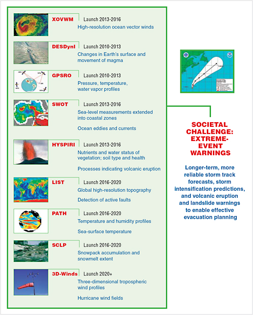
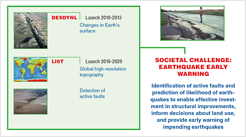
Extreme events, including severe storms, heat waves, earthquakes, and volcanic eruptions. Will tropical cyclones and heat waves become more frequent and more intense? Are major fault systems nearing the release of stress via strong earthquakes?
While past investments in Earth remote sensing have provided spectacular advances, such as in the accuracy of weather predictions, the above list of challenges highlights the class of new, interrelated questions being asked by the public and policy makers as they seek to understand new risks and the vulner-abilities of a rapidly evolving Earth system. Additional issues and questions will emerge from continued system-level study of Earth. The next 20 years must bring a new level of integration in the understanding of Earth-system components.
The Earth observation plan presented here distills into a core set of space-based missions many of the key measurements needed across the range of interrelated societal challenges and Earth science areas shown in Figure 2.2. Building on lessons learned from the development and use of the current fleet of space-based instruments, the committee’s recommended set of well-defined and justified missions will
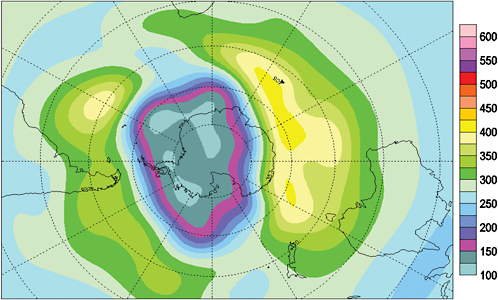
FIGURE 2.1 The 2006 hole in the Antarctic ozone layer was the most serious on record, exceeding that of 2000. It was the largest not only in surface area (matching that of 2000), but also in mass deficit, meaning that there was less ozone over the Antarctic than ever previously measured. SOURCE: NASA and ESA satellite data; see “Total Ozone Map, 2006/09/05,” available at http://www.theozonehole.com/ozonehole2006.htm. Reproduced with the permission of the Minister of Public Works and Government Services, Canada, 2007.
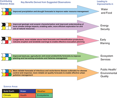
FIGURE 2.2 Addressing any given societal challenge requires scientific progress in many Earth system areas, as shown in these examples. Colored squares represent the scientific themes that contribute substantially to each of the selected benefit areas.
provide critical new observations and data for addressing emerging societal issues and for enabling major advances in scientific understanding.
The recommended missions address what are considered to be the highest-priority observational needs. To avoid the technical and cost problems associated with overly ambitious missions, the plan limits the instrument set on any mission to one that can deliver clear synergies between observations. In time, it may prove necessary to consider alternative institutional arrangements for executing these inherently multidiscipline, multiagency missions. In particular, as the plans of other space-faring nations and organizations crystallize, their contributions to meeting observational needs will have to be carefully evaluated. Articulated in the next section are the key elements of the current Earth-observing system that are essential components of the observation system for the next decade.
SETTING THE FOUNDATION: OBSERVATIONS IN THE CURRENT DECADE
Over the past 40 years, the U.S. civilian agencies have built an increasingly capable space-based Earth-observing system. NOAA has continued to deploy and maintain an operational system of weather satellites and expand the utility of these observations (Box 2.1). In 2004, NASA completed deployment of its ambitious Earth Observing System (EOS) research fleet consisting of three multi-instrumented spacecraft (Terra, Aqua, and Aura) designed to characterize most of the major Earth system components. NASA also complemented EOS with several smaller, more focused missions and instruments (on international partner spacecraft) that extended capability related to weather and climate. In addition, USGS and NASA have continued their collaboration on ecosystem science and related societal benefit areas through the Landsat mission series. The result of these efforts has been a steadily increasing number of space-based observa-
|
BOX 2.1 EMERGING APPLICATIONS USING POES AND GOES OPERATIONAL MEASUREMENTS In addition to its primary role in weather forecasting, NOAA has been working with other agencies and institutions to create operational data products that support capabilities in areas of benefit to society such as fire detection and air quality monitoring. Fire Detection Monitoring wildfires is a difficult task in parts of the world that have high levels of biological diversity in remote locations. The Center for Applied Biodiversity at Conservation International, in collaboration with the University of Maryland, uses data from the MODIS Rapid Response System1 to provide an e-mail alert system that warns of fires in or near protected areas. The service is available at no cost by subscription.2 For the past 10 years the Cooperative Institute for Meteorological Satellite Studies at the University of Wisconsin-Madison has used the GOES series of satellites to monitor fires and smoke in the Western Hemisphere. Multispectral GOES-8 imagery (visible, and at 3.9, 10.7, and 12 µm) is used to identify and catalog fire activity in South America associated with deforestation, grassland management, and agriculture. This effort has yielded the Automated Biomass Burning Algorithm (ABBA).3 In 2002, NOAA’s Satellite Products and Services Review Board approved the transition from preoperational to operational status of the Wildfire Automated Biomass Burning Algorithm (WF-ABBA) data product. Air Quality Monitoring Air NOW is a government program that involves the EPA, NOAA, NASA, the National Park Service, the news media, and tribal, state, and local agencies.4 The program reports conditions for ozone and particulate pollution to provide the public with easy access to daily air quality index (AQI) forecasts and real-time air quality conditions for more than 300 cities. USA Today is also an Air NOW partner. The University of Maryland, Baltimore County, operates an air quality Web site, “The Smog Blog,”5 with daily posts and NASA satellite images, EPA data, and so on. There have been more than 3 million hits over 2 years, about 15,000 visits per month, and about 800 unique visitors per week, including EPA, NASA, NOAA, and the states.
|
tions currently provided by 29 operating spacecraft and 122 instruments (including both U.S. missions and international missions with U.S. instruments; for lists of missions and instruments, see CEOS, 2002). That will constitute the high-water mark in observing capability unless the United States alters course immediately (Figures 2.3 and 2.4).
The extensive scientific and societal contributions of the NOAA-NASA-USGS satellite observing capabilities are evidenced by the thousands of scientific publications and applications of the data for environmental forecasts, a record of accomplishment mentioned in Chapter 1 and detailed with numerous examples in Part III of this report. As noted in Chapter 1, perhaps the largest impact of space-based observations to date has been improved weather forecasting and the many societal benefits stemming from that capability (Hollingsworth et al., 2005). The National Weather Service’s current practice of providing 10-day weather forecasts is a familiar reminder of the scientific gains made in the past decade.
Space-based observations have also figured prominently in climate research (NRC, 2004). Factors that drive climate change are usefully separated into forcings and feedbacks. A climate forcing is an energy imbalance imposed on the climate system externally or by human activities. Examples include changes in solar energy output, volcanic emissions, deliberate land modification, and anthropogenic emissions of greenhouse gases, aerosols, and their precursors. A climate feedback is an internal climate process that amplifies or dampens the climate response to a specific forcing. An example is the increase in atmospheric water vapor that is triggered by warming due to rising carbon dioxide (CO2) concentrations, which acts to further amplify the warming because of the greenhouse properties of water vapor.
Observations of key climate forcings and feedbacks, diagnostics (e.g., temperature, sea level), and the consequences of climate change (e.g., sea ice decrease) have helped to identify potentially dangerous changes in Earth’s climate. These observations have catalyzed climate research and enabled substantial improvements in climate models. In fact, these improvements have brought into existence a class of Earth system models1 that couple atmosphere, ocean, land, and cryosphere systems. These models not only provide better estimates of spatially and temporally resolved patterns of climate change but also provide a basis for addressing other environmental challenges, such as changes in biogeochemical cycles of carbon and nitrogen and the effects of these changes now and in the future (Figure 2.5).
Despite these advances, the extraordinary foundation of global observations is in decline. Between 2006 and the end of the decade, the number of operating sensors and instruments will likely decrease by around 40 percent, given that most satellites in NASA’s current fleet are well past their nominal lifetimes. Furthermore, the replacement sensors on the National Polar-orbiting Operational Environmental Satellite System (NPOESS), when they exist, are generally less capable than their EOS counterparts. This decreased quantity of space-borne assets will persist into the early part of the next decade (see Figures 2.3 and 2.4).
Partly causing and certainly amplifying the observational collapse of space-based measurements is the decline in NASA’s Earth science budget. From 2000 to 2006, this part of NASA’s budget decreased by more than 30 percent when adjusted for inflation (Figure 2.6). This reduction, if it persists, translates to approximately $4 billion less to develop Earth science missions over the next decade. That decrease could mean, for example, some 8 to 12 fewer space-based research missions and perhaps $1 billion less for associated research and analysis.
The NASA-NOAA EOS satellite system, launched beginning in the late 1990s, is aging, and the existing plan for the future is entirely inadequate to meet the coming challenges. The NOAA budget has been growing (see Figure 2.7), but this growth is now swamped by the large cost overruns in the NPOESS
|
1 |
For example, Geophysical Fluid Dynamics Laboratory and National Center for Atmospheric Research Earth system models (see www.cgd.ucar.edu/research/models/ccsm.html). |
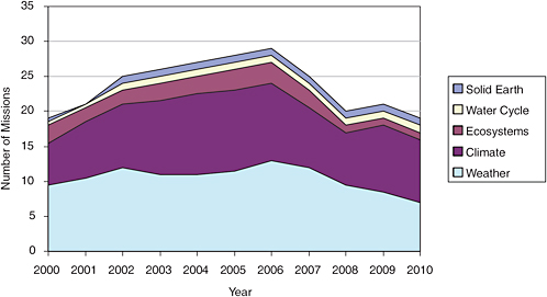
FIGURE 2.3 Number of U.S. space-based Earth observation missions in the current decade. An emphasis on climate and weather is evident, as is a decline in the number of missions near the end of the decade. For the period from 2007 to 2010, missions were generally assumed to operate for 4 years past their nominal lifetimes. Most of the missions were deemed to contribute at least slightly to human health issues, and so health is not presented as a separate category. SOURCE: Information from NASA and NOAA Web sites for mission durations.
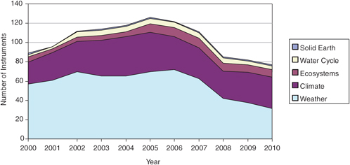
FIGURE 2.4 Number of U.S. space-based Earth Observation instruments in the current decade. An emphasis on climate and weather is evident, as is a decline in the number of instruments near the end of the decade. For the period from 2007 to 2010, missions were generally assumed to operate for 4 years past their nominal lifetimes. Most of the missions were deemed to contribute at least slightly to human health issues, and so health is not presented as a separate category. SOURCE: Information from NASA and NOAA Web sites for mission durations.
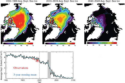
FIGURE 2.5 Intergovernmental Panel on Climate Change (IPCC) future scenario runs with the National Center for Atmospheric Research’s CCSM3 show abrupt transitions in September sea ice cover. In the most dramatic event, shown here, the ice cover goes in a decade from conditions similar to those observed in the 1990s to essentially September ice-free conditions. This change is driven by a number of factors: the thinning of the ice cover to a more vulnerable state; increases in Arctic ocean heat transport, which possibly trigger the event; and the albedo feedback, which accelerates the ice retreat. SOURCE: M.M.Holland, C.M.Bitz, and B.Tremblay, 2006, Future abrupt reductions in the summer Arctic sea ice, Geophys. Res. Lett. 33:L23503, doi:10.1029/2006GL028024. Copyright 2006 American Geophysical Union. Reproduced by permission of American Geophysical Union.
program. It also appears likely that the GOES-R program will experience cost growth.2 Completing even the descoped NPOESS program will require several billion dollars beyond the funding planned as recently as December 2005.3 Thus, NPOESS represents a major lien on future budgets, one that is so great that the agency’s ability to provide observations in support of climate research or other noncore missions will be severely compromised.
Among the many missions expected to cease over the next few years, the committee has identified several in NOAA and NASA that are providing critical information now and that need to be sustained into the next decade—both to continue important time series and to provide the foundation necessary for the recommended future observations. In NOAA, many observational capabilities need to be restored to NPOESS, but this topic must be considered as part of a reexamination of the logic, costs, and benefits of the current (September 2006) NPOESS and GOES-R plan. The reexamination of NPOESS and GOES-R will be conducted by a fast-track NRC study to be conducted and concluded in 2007.
The present committee’s analysis of the implications of NPOESS instrument descopes and cancellations is hampered by the absence of information about changes in key sensors. In particular, the Conical-Scanning Microwave Imager/Sounder (CMIS) instrument on NPOESS, which was to have provided continuity of records of sea-surface temperature and sea ice—time series critical to global climate studies—has been canceled, and the specifications for its replacement, the Microwave Imager/Sounder (MIS), are not yet known.4 Similarly, the mitigation plan for the now-demanifested altimeter, ALT, is not yet known.
The continuity of several measurements is of sufficient importance to climate research, ozone monitoring, or operational weather systems to deserve immediate attention. Those for climate include total solar irradiance and Earth radiation; for ozone, ozone limb sounding capability and total solar irradiance; and for weather, sea-surface vector winds and temperature and water vapor soundings from geostationary and polar orbits. As detailed in the committee’s interim report (NRC, 2005), the substitution of passive microwave sensor data for active scatterometry data would worsen El Niño and hurricane forecasts and weather forecasts in coastal areas.5 Nevertheless, given the precarious status of existing surface wind measurements,6 it is imperative that a measurement capability, such as the one on MetOp, be available to prevent a data gap when the NASA QuikSCAT mission terminates.
|
2 |
See testimony of Under Secretary for Oceans and Atmosphere VADM Conrad C.Lautenbacher, USN (Ret.) before the House Committee on Science (Chairman Sherwood Boehlert, R-NY) on the GAO GOES-R report, September 29, 2006. Available at http://www.legislative.noaa.gov/Testimony/lautenbacher092906.pdf. |
|
3 |
See testimony of Under Secretary for Oceans and Atmosphere VADM Conrad C. Lautenbacher, Jr., USN (Ret.) before the House Committee on Science (Chairman Sherwood Boehlert, R-NY) on the results of the Nunn-McCurdy Certification Review of the National Polar-orbiting Operational Environmental Satellite System (NPOESS), June 8, 2006. Available at http://www.legislative.noaa.gov/Testimony/lautenbacher060806.pdf. |
|
4 |
CMIS was also to provide measurements of sea-surface vector winds and all-weather profiles of atmospheric temperature and humidity. It also had important capabilities for measurement of soil moisture and precipitation. See “NPOESS ERA Microwave Imager,” presentation at a NOAA conference in Silver Spring, Md., on October 26, 2006, available at http://www.ipo.noaa.gov/polarmax/2006/day03/5.5Kunkee_20061001_PolarMax_MIS_v2.ppt. |
|
5 |
The passive system does not provide useful wind direction for winds of 5 meters per second or less (the scatterometer threshold is 2 meters per second). Moreover, wind-direction errors for winds at 6 to 8 meters per second (the wind-speed range that forces ENSO events) will be double those of the active scatterometer. The median global wind speed is about 7 meters per second, which suggests that a passive system will not provide reliable information on direction for about half the winds. In addition, rain and land contamination of wind vectors will be greater with a passive system than with a scatterometer and thus limits their use in forecasts of hurricanes and weather in coastal regions. See presentations at a NASA/NOAA workshop, “Satellite Measurements of Ocean Vector Winds: Present Capabilities and Future Trends,” Florida International University, Miami, Fla., February 8–10, 2005, available at http://cioss.coas.oregonstate.edu/CIOSS/workshops/miami_meeting/Agenda.html. |
|
6 |
NRC (2005), pp. 19–20. |
Recommendation:7 NOAA should restore several key climate, environmental, and weather observation capabilities to its planned NPOESS and GOES-R8 missions; namely:
-
Measurements of ocean vector winds and all-weather sea-surface temperatures descoped from the NPOESS C1 launch should be restored to provide continuity until the CMIS replacement is operational on NPOESS C2 and higher-quality active scatterometer measurements (from XOVWM, described in Table 2.1) can be undertaken later in the next decade.
-
The limb sounding capability of the Ozone Monitoring and Profiling Suite (OMPS) on NPOESS should be restored.9
The committee also recommends that NOAA:
-
Ensure the continuity of measurements of Earth’s radiation budget (ERB) and total solar irradiance (TSI) through the period when the NPOESS spacecraft will be in orbit by:
-
Incorporating on the NPOESS Preparatory Project (NPP)10 spacecraft the existing “spare” CERES instrument, and, if possible, a TSI sensor, and
-
Incorporating these or similar instruments on the NPOESS spacecraft that will follow NPP, or ensuring that measurements of TSI and ERB are obtained by other means.
-
-
Develop a strategy to restore the previously planned capability to make high-temporal and high-vertical-resolution measurements of temperature and water vapor from geosynchronous orbit.
The high-temporal- and high-vertical-resolution measurements of temperature and water vapor from geosynchronous orbit were originally to be delivered by the Hyperspectral Environmental Sensor (HES) on the GOES-R spacecraft. Recognizing the technological challenges and accompanying potential for growth in acquisition costs for HES, the committee recommends consideration of the following approaches:
-
Working with NASA, complete the GIFTS instrument, deliver it to orbit via a cost-effective launch and spacecraft opportunity, and evaluate its potential to be a prototype for the HES instrument, and/or
-
Extend the HES study contracts focusing on cost-effective approaches to achieving essential sounding capabilities to be flown in the GOES-R time frame.
|
7 |
Inaccurate wording of this four-part recommendation in the initially released prepublication copy of this report was subsequently corrected by the committee to reflect its intent to recommend a capability for ensuring continuity of the ongoing record of measurements of total solar irradiance and of Earth’s radiation budget. As explained in the description of the CLARREO mission in Chapter 4, the committee recommends that the CERES Earth radiation budget instrument and a total solar irradiance sensor be flown on the NPP satellite and that these instruments or their equivalent be carried on the NPOESS spacecraft or another suitable platform. |
|
8 |
GOES-R is the designation for the next generation of geostationary operational environmental satellites (GOES). See http://osd.goes.noaa.gov/ and http://goespoes.gsfc.nasa.gov/goes/spacecraft/r_spacecraft.html. The first launch of the GOES-R series satellite was recently delayed from the 2012 time frame to December 2014. |
|
9 |
Without this capability, no national or international ozone-profiling capability will exist after the EOS Aura mission ends in 2010. This capability is key to monitoring ozone-layer recovery in the next two decades and is part of NOAA’s mandate through the Clean Air Act. |
|
10 |
The NASA-managed NPOESS Preparatory Project (NPP), a joint mission involving NASA and the NPOESS Integrated Program Office (IPO), has a twofold purpose: (1) to provide continuity for a selected set of calibrated observations with the existing Earth Observation System measurements for Earth science research and (2) to provide risk reduction for four of the key sensors that will fly on NPOESS, as well as the command and data-handling system. The earliest launch set for NPP is now September 2009, a delay of nearly 3 years from the plans that existed prior to the 2006 Nunn-McCurdy certification. See http://jointmission.gsfc.nasa.gov/ and http://www.nasa.gov/pdf/1 50011 main_NASA_Testimony_for_NPOESS-FINAL.pdf. |
The committee believes that such a process will both strengthen the technological foundation of GEO-based soundings and provide the requisite experience for efficient operational implementation of GEO-based soundings. It notes that this issue will be studied in more detail as part of the NRC fast-track study scheduled for 2007.
Finally, although there are many concerns about NASA’s out-year budget, two topics deserve particular mention. One is changing global precipitation patterns resulting from changing climate. The other is changing patterns of land use due to the needs of a growing population, the expansion and contraction of economies, and the intensification of agriculture. Both concerns have been highlighted in the scientific and policy literature (e.g., IPCC, 2001; Millennium Ecosystem Assessment, 2005) and were addressed in the committee’s interim report (NRC, 2005). The committee believes that it is vital to maintain global precipitation measurements as offered by the Global Precipitation Measurement (GPM) mission, and to continue to document biosphere changes indicated by measurements made from instruments on the Landsat series of spacecraft.
Recommendation: NASA should ensure continuity of measurements of precipitation and land cover by:
-
Launching the GPM mission in or before 2012, and
-
Securing before 2012 a replacement for collection of Landsat 7 data.
The committee also recommends that NASA continue to seek cost-effective, innovative means for obtaining information on land cover change.
By maintaining sustained measurements of these key climate and weather variables, the nation will be in a good position to achieve the integrated Earth information system envisioned by the committee for the next decade. The set of observational missions that will help to deliver that vision is described in the next section.
NEW OBSERVATIONS FOR THE NEXT DECADE
A prioritized set of missions forms the core recommendation of this report. In establishing the set, the committee recognized that a successful program is more than the sum of its parts. The priority-setting method was designed to achieve a robust, integrated program—one that does not crumble if one or several missions in the prioritized list are removed or delayed or if the mission list must evolve to accommodate changing needs. The method was also intended to enable augmentation of an enhanced program if additional resources become available beyond those anticipated by the committee. Robustness depends on the strength of the overall program, not on the particular missions on the list. It is the range of observations that must be protected rather than the individual missions themselves.
Recommendation: In addition to implementing the re-baselined NPOESS and GOES program and completing research missions currently in development, NASA and NOAA should undertake the set of 17 missions11 recommended in Tables 2.1 and 2.2 comprising low-cost (<$300 million), medium-cost ($300 million to $600 million), and large-cost ($600 million to $900 million) missions and phased appro-
TABLE 2.1 Launch, Orbit, and Instrument Specifications for Missions Recommended to NOAA
|
Decadal Survey Mission |
Mission Description |
Orbita |
Instruments |
Rough Cost Estimate (FY 06 $million) |
|
2010–2013 |
|
|
|
|
|
CLARREO (instrument reflight components) |
Solar and Earth radiation characteristics for understanding climate forcing |
LEO, SSO |
Broadband radiometer |
65 |
|
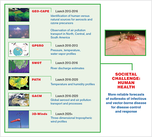
GPSRO |
High-accuracy, all-weather temperature, water vapor, and electron density profiles for weather, climate,and space weather |
LEO |
GPS receiver |
150 |
|
2013–2016 |
|
|
|
|
|
XOVWM |
Sea-surface wind vectors for weather and ocean ecosystems |
LEO, SSO |
Backscatter radar |
350 |
|
NOTE: Missions are listed by cost. Colors denote mission cost categories as estimated by the committee. Green and blue shading indicates medium-cost ($300 million to $600 million) and small-cost (<$300 million) missions, respectively. The missions are described in detail in Part II, and Part III provides the foundation for selection. aLEO, low Earth orbit; SSO, Sun-synchronous orbit. |
||||
priately over the next decade.12 Larger, facility-class (>$1 billion) missions are not recommended. As part of this strategy:
-
NOAA should transition to operations three research observations. These are vector sea-surface winds; GPS radio occultation temperature, water vapor, and electron density soundings; and total solar irradiance (restored to NPOESS). Approaches to these transitions are provided through the recommended XOVWM, GPSRO, and CLARREO missions listed in Table 2.1.
-
NASA should implement a set of 15 missions phased over the next decade. All of the appropriate low Earth orbit (LEO) missions should include a Global Positioning System (GPS) receiver to augment operational measurements of temperature and water vapor. The missions and their specifications are listed in Table 2.2.
The primary work in developing the recommended decadal observing plan took place within the survey’s science panels, which were organized to address multidiscipline issues in climate change, water resources, ecosystem health, human health, solid-Earth and natural hazards, and weather. This categorization is similar to the organizing structure used in the GEOSS process. Each panel first set priorities among an array of space-based measurement approaches and mission concepts by applying the criteria listed in Box 2.2. Recommendations in previous community-based reports, such as those of the World Meteorological Organization, were also considered (e.g., GCOS, 2003, 2004, 2006a,b; WMO, 2005). The complete set of high-priority observations and missions identified by the panels numbered about 35, a substantial reduction from the more than 100 possible missions suggested in the responses to the committee’s request
|
12 |
Tables 2.1 and 2.2 include cost estimates for the 17 missions. These estimates include costs for development, launch, and 3 years of operation for NASA research missions and 5 years of operation for NOAA operational missions. Estimates also include funding for a science team to work on algorithms and data preparation, but not funding for research and analysis to extract science from the data. All estimates are in fiscal year 2006 dollars. |
TABLE 2.2 Launch, Orbit, and Instrument Specifications for Missions Recommended to NASA
|
Decadal Survey Mission |
Mission Description |
Orbita |
Instruments |
Rough Cost Estimate (FY 06 $million) |
|
2010–2013 |
|
|
|
|
|
CLARREO (NASA portion) |
Solar and Earth radiation; spectrally resolved forcing and response of the climate system |
LEO, Precessing |
Absolute, spectrally resolved interferometer |
200 |
|
SMAP |
Soil moisture and freeze-thaw for weather and water cycle processes |
LEO, SSO |
L-band radar L-band radiometer |
300 |
|
ICESat-II |
Ice sheet height changes for climate change diagnosis |
LEO, Non-SSO |
Laser altimeter |
300 |
|
DESDynl |
Surface and ice sheet deformation for understanding natural hazards and climate; vegetation structure for ecosystem health |
LEO, SSO |
L-band InSAR Laser altimeter |
700 |
|
2013–2016 |
|
|
|
|
|
HyspIRI |
Land surface composition for agriculture and mineral characterization; vegetation types for ecosystem health |
LEO, SSO |
Hyperspectral spectrometer |
300 |
|
ASCENDS |
Day/night, all-latitude, all-season CO2 column integrals for climate emissions |
LEO, SSO |
Multifrequency laser |
400 |
|
SWOT |
Ocean, lake, and river water levels for ocean and inland water dynamics |
LEO, SSO |
Ka- or Ku-band radar Ku-band altimeter Microwave radiometer |
450 |
|
GEO-CAPE |
Atmospheric gas columns for air quality forecasts;ocean color for coastal ecosystem health and climate emissions |
GEO |
High-spatial-resolution hyperspectral spectrometer Low-spatial-resolution imaging spectrometer IR correlation radiometer |
550 |
|
ACE |
Aerosol and cloud profiles for climate and water cycle; ocean color for open ocean biogeochemistry |
LEO, SSO |
Backscatter lidar Multiangle polarimeter Doppler radar |
800 |
|
2016–2020 |
|
|
|
|
|
LIST |
Land surface topography for landslide hazards and water runoff |
LEO, SSO |
Laser altimeter |
300 |
|
PATH |
High-frequency, all-weather temperature and humidity soundings for weather forecasting and sea-surface temperatureb |
GEO |
Microwave array spectrometer |
450 |
|
GRACE-II |
High-temporal-resolution gravity fields for tracking large-scale water movement |
LEO, SSO |
Microwave or laser ranging system |
450 |
|
SCLP |
Snow accumulation for freshwater availability |
LEO, SSO |
Ku- and X-band radars K- and Ka-band radiometers |
500 |
|
GACM |
Ozone and related gases for intercontinental air quality and stratospheric ozone layer prediction |
LEO, SSO |
UV spectrometer IR spectrometer Microwave limb sounder |
600 |
|
3D-Winds (Demo) |
Tropospheric winds for weather forecasting and pollution transport |
LEO, SSO |
Doppler lidar |
650 |
|
NOTE: Missions are listed by cost. Colors denote mission cost categories as estimated by the committee. Pink, green, and blue shading indicates large-cost ($600 million to $900 million), medium-cost ($300 million to $600 million), and small-cost (<$300 million) missions, respectively. Detailed descriptions of the missions are given in Part II, and Part III provides the foundation for their selection. aLEO, low Earth orbit; SSO, Sun-synchronous orbit; GEO, geostationary Earth orbit. bCloud-independent, high-temporal-resolution, lower-accuracy sea-surface temperature measurement to complement, not replace, global operational high-accuracy sea-surface temperature measurement. |
||||
|
BOX 2.2 CRITERIA USED BY THE PANELS TO CREATE RELATIVE RANKINGS OF MISSIONS
Note that these guidelines are not in priority order, and they may not reflect all of the criteria considered by the panels. |
for information (see Appendixes D and E) and numerous other mission possibilities raised by individual panel members. The assessment and priority setting were based on an overall analysis by panel members as to how well each mission would satisfy the criteria and the top-level community objectives (Table 2.3). The panel reports in Part III document the panels’ analyses.
Development of a coherent set of recommended missions was guided by the committee’s overarching recommendation, given in Chapter 1. Most importantly, the committee sought an observing system that would treat Earth as a system, improving knowledge of weather and climate and expanding the scope of observations to address other key societal issues more fully. In developing the mission list, the committee affirmed several important principles:
-
Establish and maintain balance to support system science. The Earth observation and information system program should seek to achieve and maintain balance in a number of thematic areas in order to support the broad array of demands for Earth information. Balance is required in the types of measurements (research, sustained, and operational), in the sizes and complexity of missions, across science disciplines, and across technology maturity levels.
-
Emphasize cross-benefiting observations. Earth’s highly interrelated processes imply that Earth knowledge must be built largely through an understanding of how the processes interact with each other. An effective observational system must incorporate the need for cross-benefiting and interdisciplinary observations characterized by measurements across a wide range of space, time, and spectral characteristics.
-
Gain leverage. Resources of the many partners and related efforts—of other agencies, international programs, and the private sector13—should be leveraged to the greatest extent possible to achieve the most comprehensive observing system possible compatible with available national resources.
TABLE 2.3 Contribution of Recommended Missions to the Priority Science Mission/Observation Types Identified by the Individual Study Panels as Discussed in Part III
|
Recommended Mission |
Mission/Observation Type Recommended by Individual Panel |
Panel |
|
CLARREO |
Radiance calibration Ozone processes |
Climate Health |
|
GPSRO |
Radiance calibration Ozone processes Cold seasons Radio occultation |
Climate Health Water Weather |
|
SMAP |
Heat stress and drought Algal blooms and waterborne infectious disease Vector-borne and zoonotic disease Soil moisture and freeze-thaw state Surface water and ocean topography |
Health Health Health Water Water |
|
ICESat-II |
Clouds, aerosols, ice, and carbon Ecosystem structure and biomass Sea ice thickness, glacier surface elevation, glacier velocity |
Climate Ecosystem Water |
|
DESDynl |
Ice dynamics Ecosystem structure and biomass Heat stress and drought Vector-borne and zoonotic disease Surface deformation Sea ice thickness, glacier surface elevation, glacier velocity |
Climate Ecosystem Health Health Solid Earth Water |
|
XOVWM |
Ocean circulation, heat storage,and climate forcing |
Climate |
|
HyspIRI |
Ecosystem function Heat stress and drought Vector-borne and zoonotic disease Surface composition and thermal properties |
Ecosystem Health Health Solid Earth |
|
ASCENDS |
Carbon budget Ozone processes |
Ecosystem Health |
|
SWOT |
Ocean circulation, heat storage,and climate forcing Algal blooms and waterborne infectious disease Vector-borne and zoonotic disease Surface water and ocean topography |
Climate Health Health Water |
|
GEO-CAPE |
Global ecosystem dynamics Ozone processes Heat stress and drought Acute toxic pollution releases Air pollution Algal blooms and waterborne infectious disease Inland and coastal water quality Tropospheric aerosol characterization Tropospheric ozone |
Ecosystem Health Health Health Health Weather Health Water Weather |
|
Recommended Mission |
Mission/Observation Type Recommended by Individual Panel |
Panel |
|
ACE |
Clouds, aerosols, ice, and carbon Ice dynamics Global ocean productivity Ozone processes Acute toxic pollution releases Air pollution Algal blooms and waterborne infectious disease Aerosol-cloud discovery Tropospheric aerosol characterization Tropospheric ozone |
Climate Climate Ecosystem Health Health Health Health Weather Weather Weather |
|
LIST |
Heat stress and drought Vector-borne and zoonotic disease High-resolution topography |
Health Health Solid Earth |
|
PATH |
Heat stress and drought Algal blooms and waterborne infectious disease Vector-borne and zoonotic disease Cold seasons All-weather temperature and humidity profiles |
Health Health Health Water Weather |
|
GRACE-II |
Ocean circulation, heat storage,and climate forcing Groundwater storage, ice sheet mass balance,ocean mass |
Climate Water |
|
SCLP |
Cold seasons |
Water |
|
3D-Winds |
Water vapor transport Tropospheric winds |
Water Weather |
|
GACM |
Global ecosystem dynamics Ozone processes Acute toxic pollution releases Air pollution Cold seasons Tropospheric aerosol characterization Tropospheric ozone |
Ecosystem Health Health Health Water Weather Weather |
To develop its plan, the committee exploited science and measurement synergies among the various mission priorities of the individual study panels to create a capable and affordable observing system. For example, the committee recognized that ice sheet change, solid-Earth hazards, and ecosystem health objectives are together well addressed by a combination of radar and lidar instrumentation. As a result, a pair of missions flying in the same time frame was devised to address the three societal issues.
The phasing of missions over the next decade was driven primarily by consideration of the maturity of key prediction and forecast tools and the timing of particular observations needed for maintaining or improving those tools. For fairly mature forecast tools, such as weather forecast models, the need for routine sea-surface wind observations14 by relatively mature instrument techniques set the phasing needed to provide continuity between the current QuikSCAT instrument, the planned CMIS replacement instrument on NPOESS, and the Extended Ocean Vector Winds Mission (XOVWM) recommended by the
|
14 |
See, for example, pp. 4–5 of the oceans community letter to the decadal survey, available at http://cioss.coas.oregonstate.edu/CIOSS/Documents/Oceans_Community_Letter.pdf, and the report of the NOAA Operational Ocean Surface Vector Winds Requirements Workshop, National Hurricane Center, Miami, Fla., June 5–7, 2006, P.Chang and Z.Jelenak, eds. |
committee. Continuous observations of this type, with a clear operational use, are recommended to NOAA for implementation. For less mature tools, such as for earthquake forecasting and mitigation models, the committee recommends obtaining new surface-deformation observations early in the decade to accelerate tool improvements. Observations of this type, related more to research, are recommended to NASA for implementation.
In setting the mission timing, the committee also considered mission costs relative to anticipated budgets, technology readiness, and the potential of international missions to provide alternative sources of select observations. Rough cost estimates and technology-readiness information for proposed missions were provided to the committee by NASA or culled from available information on current missions (see Box 2.3). However, the committee decided not to include possible cost sharing by international partners
|
BOX 2.3 ESTIMATING COSTS FOR MISSIONS One of the difficult challenges for the panels was creating an integrated mission set that is affordable, especially given the relatively large number of needed observations. The cost of any given Earth science mission depends on the particular requirements associated with its payload (mass, power, data rate, and so on) and architecture choices (such as orbit, launch vehicle, and downlink scenarios). Instrument complexity (e.g., detector types, cooling or heating requirements, component redundancy requirements, and moving components) can also significantly drive cost. Sophisticated mission-cost-estimation tools have been developed by NASA and a number of aerospace companies; the performance of these tools depends heavily on how well the detailed science and instrument requirements and technology readiness levels are known at the time of estimation. Responses to the committee’s request for information (see Appendixes D and E) were valuable for developing individual mission costs, but a uniform approach to cost estimation (based mainly on known costs for many current and past Earth science missions) was used by the panels to ensure consistency across the set of missions. In consultation with NASA mission designers, a budget spreadsheet was developed to identify all of the primary mission cost components, including instruments, spacecraft, launch vehicle, system engineering and management, integration and test, ground data system, mission operations, data downlink and archiving, science team, and data validation. The major cost dependences of each component were identified and the likely total cost ranges for mission components were established on the basis of data from current and past missions. For example, the spreadsheet included a choice of launch vehicle (Pegasus, Minotaur IV, Taurus, Delta II, Delta IV, and Atlas V) that depended on the selected orbit and payload mass requirements. By training the costing tool with actual mission cost information and given the assumed measurement requirements, the panels believe that cost estimates for the recommended missions vary within ±50 percent for the smallest missions and within ±30 percent for the larger missions. The cost estimates will depend directly on the exact measurement requirements for the eventual missions, and the cost uncertainty rises for missions scheduled later in the next decade and for missions requiring the most technology development. Nevertheless, the estimates provided in this study set targets for each mission that are consistent with an overall program that is also affordable. The panels recognize that the missions afforded under the estimated costs will be ones that respond to the main scientific requirements articulated by the panels in Chapters 5 through 11, but not necessarily all of the desired requirements. The selected missions reflect the panels’ prioritization of scientific observations but are not the result of an exhaustive examination of the trade-offs across the entire range of potential missions. Clearly, more detailed cost estimates are needed that examine the full range of mission trade-offs. Where possible within budget constraints, augmentation of the specified set of science observations with additional desired observables should be considered; however, NASA and the scientific community must avoid “requirements creep” and the consequent damaging cost growth. |
because such relationships are sometimes difficult to quantify. Especially given the difficult fiscal environment, the committee believes that NASA and NOAA will have to redouble their efforts to develop international partnerships, and it notes that NASA’s piecemeal approach to such partnerships in the past has reduced the effectiveness of such efforts.
Given the relatively large uncertainties attached to cost and technology-readiness estimates, the committee chose to sequence missions among three broad periods in the next decade, namely, 2010–2013, 2013–2016, and 2016–2020. Missions seen to require significant technology development—such as highpower, multifrequency lasers for three-dimensional wind and aerosol and ozone profiling, and thin-array microwave antennas and receivers for temperature and humidity sounding—were targeted for either middle or late periods of the next decade; the exact placement depended on the perceived scientific and forecasting impact of the particular observation. To avoid the problems associated with inadequate technology readiness, out-year missions should begin sooner rather than later and should exploit the early time frame to strengthen the technology foundation for missions in the middle and late periods. In addition to a longer mission timescale to enable development of technologies for those missions, there must also be specific funding for a focused technology program designed specifically to mature the requisite technologies in the preceding time periods. Such funding must be in addition to NASA’s existing basic technology development program in its Earth Science Technology Office and should be of a magnitude comparable to that of the general program. The committee included such a focused technology program when it considered the out-year budget needs (see Figure 2.11). The committee believes that establishing a clear mission set and schedule will allow for a more effective and focused technology program than was possible with the NASA program over the past 5 years.
Large uncertainties are also associated with attempts to factor international partner missions into the timing of U.S. missions during the next decade. At the beginning of the next decade, for example, there are international plans for GCOM-C (2011) and EarthCARE (2012), missions aimed at observing aerosols and clouds. As a result, the committee targeted for a later time period a U.S. mission to explore cloud and aerosol interactions. The European Space Agency’s Earth Explorer program has recently selected six mission concepts for Phase A studies, from which it will select one or two for launch in about 2013. All of the Phase A study concepts have potential value for the broader Earth science community and provide overlap with missions recommended by this committee. Accordingly, the committee emphasizes the importance of maintaining flexibility in the NASA observing program to leverage possible international activities, either by appropriate sequencing of complementary NASA and international partner missions or by exploration of possible combinations of appropriate U.S. and internationally developed instruments on various launch opportunities.
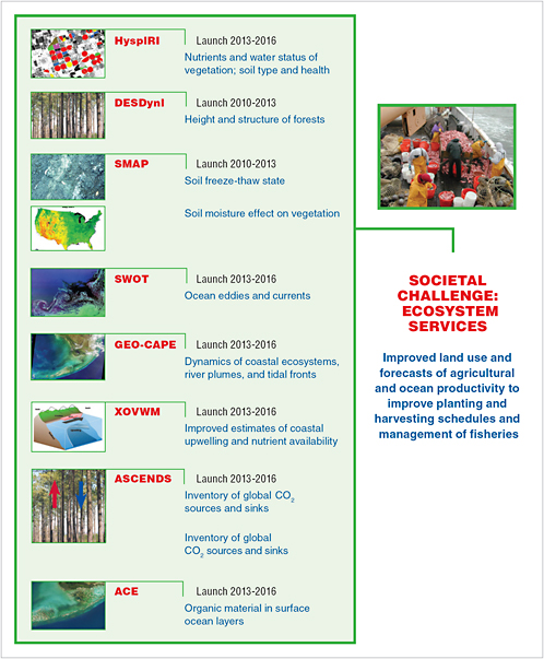
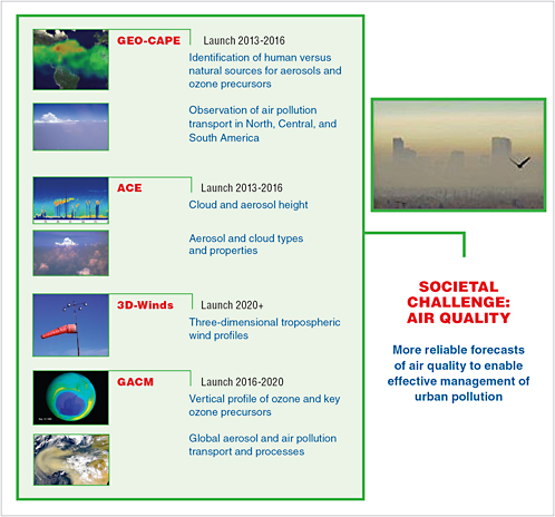
The committee’s recommended observational strategy, consisting of 14 missions for implementation by NASA, 2 missions for implementation by NOAA, and 1 mission (CLARREO) with separate components for implementation by NASA and NOAA, is summarized in Tables 2.1 (NOAA portion) and 2.2 (NASA portion). The recommended observing strategy is consistent with current national strategy as expressed in the recommendations of the U.S. Global Change Research Program (USGCRP), the U.S. Climate Change Science Program (CCSP), and the U.S. component of GEOSS. Most important, the observing strategy enables major progress across an array of important societal issues, as illustrated in Figure 2.2. The number of recommended missions and associated observations is only a small fraction of the currently operating Earth missions and observations (Figures 2.8 and 2.9). The committee believes strongly that the recommended missions form a minimal yet robust observational component of an Earth information system that is capable of addressing a broad range of societal needs.
The overall cost to implement the recommended NASA program (~$7 billion over 12 years for the 15 missions) is estimated to exceed currently projected program resources but fits well within funding levels
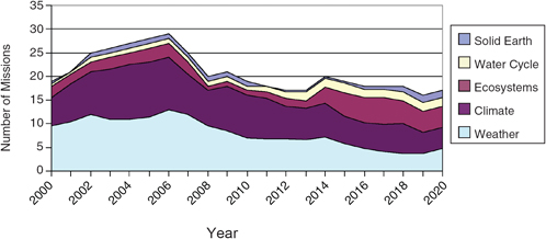
FIGURE 2.8 Space-based missions, 2000 to 2020. All of the recommended missions are assumed to operate for 7 years (3-year nominal mission plus 4 years of extended mission). The set of recommended missions is structured to provide a uniform focus across the science challenge areas. The partitioning of the missions into science themes was based on the committee’s subjective judgment. Many individual missions were judged to serve multiple themes and were partitioned accordingly. Most of the missions were deemed to contribute at least slightly to human health issues, and so health is not presented as a separate category.
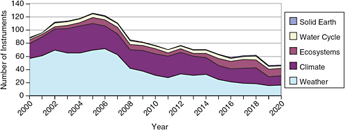
FIGURE 2.9 Space-based instruments, 2000 to 2020. All of the recommended missions are assumed to operate for 7 years (3-year nominal mission plus 4 years of extended mission). The set of recommended missions is structured to provide a uniform focus across the science challenge areas. The partitioning of the missions into science themes was based on the committee’s subjective judgment. Many individual missions were judged to serve multiple themes and were partitioned accordingly. Most of the missions were deemed to contribute at least slightly to human health issues, and so health is not presented as a separate category.
provided to NASA Earth science as recently as 2000 (Figures 2.6, 2.7, and 2.10). The committee believes that a return of NASA Earth science funding to levels prevailing at the end of the 20th century is essential for addressing emerging societal challenges in the 21 st century. To meet the ambitious schedule laid out in the committee’s plan, especially for 2010 to 2013, initial investments in technology and mission development must begin as soon as 2008. Accordingly, the committee sees a need for rapid growth in the NASA Earth science budget from about $1.5 billion per year to $2 billion per year beginning in 2008 and ending no later than 2010, as shown in Figures 2.10 and 2.11.
Severe budget problems in the NOAA NPOESS program, which carry budget liens against the program well into the next decade, make it difficult for the committee to gauge NOAA’s capacity to implement additional Earth science missions. In view of this uncertainty, the committee recommends an extremely modest set of new operational missions for implementation by NOAA, with relatively small cost implications (Figures 2.12 and 2.13). Nevertheless, implementation of the set of recommended missions, in concert with the current reduced plan for NPOESS, will ensure substantial continuity, through at least 2020, for all of the environmental data records originally targeted by the NPOESS program (JROC, 2001; see Tables 2.4 and 2.5). Broader issues associated with long-term data records for research and applications are discussed more fully in Chapter 3. In addition, as noted above, a strategy to recover lost NPOESS capabilities, especially those important for climate-related research, is the subject of a follow-on NRC study.
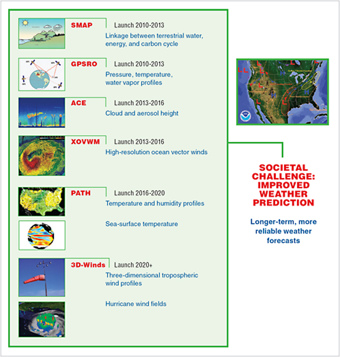
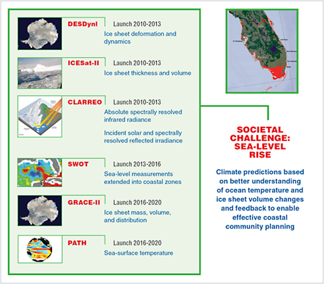
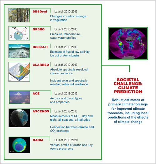
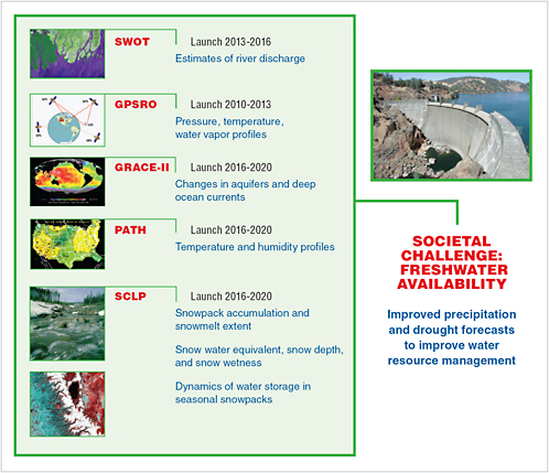
The recommended mission set listed in Tables 2.1 and 2.2 reflects an integrated and carefully sequenced plan that addresses urgent societal issues (Figures 2.14 to 2.22). Although the launch order of the missions represents, in a practical sense, a priority order, it is important to recognize that the many factors involved in developing the mission plan preclude such a simple priority setting.
As noted above, the committee generally placed technologically ready and less expensive missions earlier in the sequence of implementation. That strategy reduces the risk of mission failure and makes optimal use of the budget wedge that emerges in the committee’s recommended mission profile (see Figures 2.12 and 2.13). Consideration of each highlighted societal need made it clear to the committee that elimination of any of the recommended missions would severely limit gains with respect to at least one important societal need, and typically several. A change in an individual mission, whether forced by budget or technology, or by changing user priorities, should cause the implementing agencies to consider the ramifications for the resulting program to ensure that unacceptable gaps in measurements, or other problems, are not created.
Detailed recommendations for implementing the observing program are given in Chapter 3. Here, the committee calls attention to the fact that the missions recommended for NASA do not fit neatly in the existing structure of the systematic mission line (emphasizing strategic and/or continuous measurements, typically assigned to a NASA center for implementation) and the Earth System Science Pathfinder mission line (exploratory measurements that are competed community-wide). The committee considers all of the recommended missions to be “strategic” but recognizes that some of the less complex and less technically challenging missions could be awarded competitively rather than assigned. The committee notes that historically the broader Earth science research community’s involvement in conducting space-based missions has been almost exclusively in concert with various implementing NASA centers. Accordingly, the committee advises NASA to seek to implement the recommended set of missions as part of one strategic program, or mission line, using both competitive and noncompetitive methods to create a timely and effective program.
The observing system envisioned here will help establish a firm and sustainable foundation for Earth science and associated societal benefits in the year 2020 and beyond. It can be achieved through effective management of technology advances and international partnerships and through broad use of space-based science data by the research and decision-making communities. In looking beyond the next decade, the
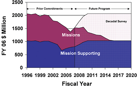
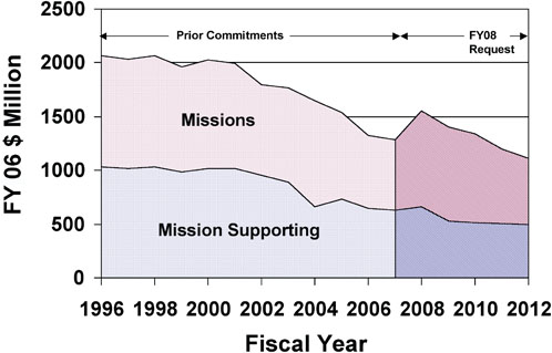
FIGURE 2.10 NASA budget for Earth science, 1996 to 2020, showing both the decline in funding during the current decade and the increase required to implement the committee’s recommendations (in fixed FY 2006 dollars). The striped areas represent future commitments to ongoing missions and research and analysis efforts. The light striped “Decadal Survey” area represents the budget wedge that would support the committee’s recommended missions and technology development in the next decade.
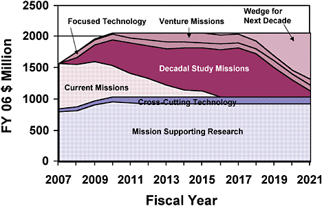
FIGURE 2.11 Detailed view of NASA budget for Earth science for 2007 to 2021 required to implement the committee’s recommendations (in fixed FY 2006 dollars). Approximately $7 billion is phased between 2008 and 2021 to support the 15 missions recommended to NASA. A mission-focused technology line of approximately $100 million per year is included to reduce risk associated with the recommended missions. NOTE: The new Venture class of recommended missions assumes $200 million for a new start every 2 years, and each mission is assumed to phase in over a 5-year period. The new starts could,for instance, include two efforts at the $100 million level or one larger $200 million activity.
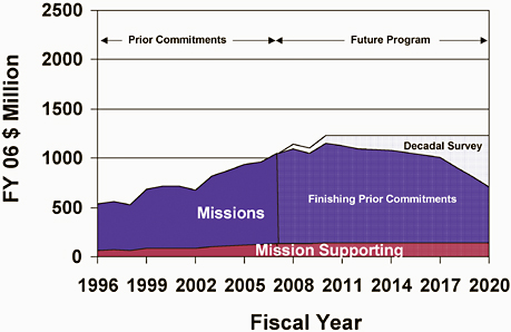
FIGURE 2.12 NOAA NESDIS budget for 1996 to 2020 showing the increase required during the current decade to support NPOESS and GOES and the maintenance of current levels required to implement the committee’s recommendations (in fixed FY 2006 dollars). The striped areas represent prior commitments to ongoing NPOESS and GOES projects. The light striped “Decadal Survey” area represents the budget wedge that would support the committee’s recommended missions and technology development in the next decade.
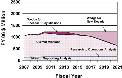
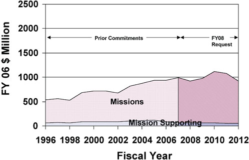
FIGURE 2.13 A detailed view of the NOAA NESDIS budget for 2007 to 2021 required to implement the committee’s recommendations (in fixed FY 2006 dollars). The small wedges are necessary to implement the recommended missions listed in Table 2.1 and to support research instrument development and the implementation of new cost-effective operational measurements.
TABLE 2.4 Contributions of Recommended Missions to Continuation or Expansion of the Environmental Data Records Defined by the 2001 NPOESS Integrated Operational Requirements Document
|
Environmental Data Record |
NPOESS Statusa |
Relevant Recommended Mission |
|
Soil moisture |
Degraded |
SMAP |
|
Aerosol refractive index/single-scattering albedo and shape |
Demanifested |
ACE |
|
Ozone total column/profile |
Reduced capability (column only) |
GACM |
|
Cloud particle size distribution |
Demanifested |
ACE |
|
Downward LW radiation (surface) |
Demanifested |
CLARREO |
|
Downward SW radiation (surface) |
Demanifested |
CLARREO |
|
Net solar radiation at TOA |
Demanifested |
CLARREO |
|
Outgoing LW radiation (TOA) |
Demanifested |
CLARREO |
|
Solar irradiance |
Demanifested |
CLARREO |
|
Ocean wave characteristics/significant wave height |
Reduced capability |
XOVWM |
|
Sea-surface height/topography—basin scale/global scale/mesoscale |
Demanifested |
SWOT |
|
NOTE: MetOp contributions to EDRs and space weather-related EDRs are not listed. aCurrent status of NPOESS’s planned capabilities to obtain the EDRs. |
||
TABLE 2.5 Contributions of Recommended Missions to Continuation or Expansion of Environmental Data Records Dependent on the Replacement for the Canceled Conical Scanning Microwave Imager/Sounder
committee recognizes not only the need to learn from implementation of the 1 7 recommended missions but also the need to efficiently transition select research observations to operational status and the need to create space-based observing opportunities aimed at fostering new science leaders and revolutionary ideas. In light of those objectives the committee makes the following recommendation:
Recommendation: U.S. civil space agencies should aggressively pursue technology development that supports the missions recommended in Tables 2.1 and 2.2; plan for transitions to continue demonstrably useful research observations on a sustained, or operational, basis; and foster innovative space-based concepts. In particular:
-
NASA should increase investment in both mission-focused and cross-cutting technology development in order to decrease technical risk in the recommended missions and promote cost reduction across multiple missions. Early technology-focused investments through extended mission Phase A studies are essential.
-
To restore more frequent launch opportunities and to facilitate the demonstration of innovative ideas and higher-risk technologies, NASA should create a new Venture class of low-cost research and application missions (~$100 million to $200 million). These missions should focus on fostering revolutionary innovation and on training future leaders of space-based Earth science and applications.
-
NOAA should increase investment in identifying and facilitating the transition of demonstrably useful research observations to operational use.
The Venture class of missions, in particular, would replace and be very different from the current ESSP mission line, which is increasingly a competitive means for implementing NASA’s strategic missions. Priority would be given to cost-effective, innovative missions rather than those with excessive scientific and technological requirements. The Venture class could include stand-alone missions that use simple, small instruments, spacecraft, and launch vehicles; more complex instruments of opportunity flown on partner spacecraft and launch vehicles; or complex sets of instruments flown on suitable suborbital platforms to address focused sets of scientific questions. These missions could focus on establishing new research avenues or on demonstrating key application-oriented measurements. Key to the success of such a program will be maintaining a steady stream of opportunities for community participation in the development of innovative ideas, which requires that strict schedule and cost guidelines be enforced for the program participants.
REFERENCES
CEOS (Committee on Earth Observation Satellites). 2002. Earth Observation Handbook. European Space Agency, Paris, France.
GCOS (Global Climate Observing System). 2003. The Second Report on the Adequacy of the Global Observing Systems for Climate in Support of the UNFCCC. GCOS-82. WMO/TD No. 1143. World Meteorological Organization, Geneva, Switzerland.
GCOS. 2004. Implementation Plan for the Global Observing System for Climate in Support of the UNFCC. GCOS-92. WMO/TD 1219. World Meteorological Organization, Geneva, Switzerland.
GCOS. 2006a. Systematic Observation Requirements for Satellite-Based Products for Climate. GCOS-107. WMO/TD No. 1338. World Meteorological Organization, Geneva, Switzerland.
GCOS. 2006b. CEOS response to the GCOS Implementation Plan September 2006. Satellite Observations of the Climate System. GCOS Steering Committee, Session XIV, Geneva, Switzerland, 10–12 October, 2006, GCOS SC-XIV Doc. 17, Item 7.2. World Meteorological Organization, Geneva, Switzerland.
Hollingsworth, A., S.Uppala, E.Klinker, D.Burridge, F.Vitart, J.Onvlee, J.W.De Vries, A.De Roo, and C.Pfrang. 2005. The transformation of Earth-system observations into information of socio-economic value in GEOSS. Q.J.R. Meteorol. Soc. 131:3493–3512.
IPCC (Intergovernmental Panel on Climate Change). 2001. Climate Change 2001: Impacts, Adaptation and Vulnerability. Cambridge University Press, Cambridge, U.K.
JROC (Joint Requirements Oversight Council). 2001. NPOESS Integrated Operational Requirements Document (IORD) II. December. Available at http://www.osd.noaa.gov/rpsi/IORDII_011402.pdf.
Millennium Ecosystem Assessment. 2005. Ecosystems and Human Well-being: Synthesis. Island Press, Washington, D.C. Available at http://www.millenniumassessment.org/en/Synthesis.aspx.
NRC (National Research Council). 2003. The Sun to the Earth—and Beyond: A Decadal Research Strategy in Solar and Space Physics. The National Academies Press, Washington, D.C.
NRC. 2004. Climate Data Records from Environmental Satellites: Interim Report. The National Academies Press, Washington, D.C.
NRC. 2005. Earth Science and Applications from Space: Urgent Needs and Opportunities to Serve the Nation. The National Academies Press, Washington, D.C.
WMO (World Meteorological Organization). 2005. Implementation Plan for Evolution of Space and Surface-Based Sub-Systems of the GOS. WMO/TD No. 1267. World Meteorological Organization, Geneva, Switzerland.


