
10
Weather Science and Applications
OVERVIEW
The dramatic improvement over the last few decades in numerical weather prediction (NWP) for forecasts of a day to a week or more has been a remarkable scientific achievement. Furthermore, weather and short-term climate changes associated with El Niño and La Niña events are now skillfully predicted several months in advance. Those improvements were enabled by assimilation of observations into computer atmospheric models, which were improved through better scientific understanding of the atmosphere and related parts of the Earth system. The general public, decision makers, and industry now depend on multiday forecasts and are pressing for further improvements.
Although extreme events (Figure 10.1) and associated impacts on people attract the most attention, both the general public and economic decision makers also rely on the quality of everyday forecasts. For example, the development of renewable energy sources (e.g., wind, solar, and biofuels) will require weather information to locate facilities and to manage the uncertainty associated with variability in natural resources. A large component of the U.S. gross domestic product (about $2 trillion to $3 trillion) is directly or indirectly sensitive to weather and climate (NRC, 2003b). The economic impact (Figure 10.2) is evident in natural-resource management, energy, finance, insurance, real estate, services, retail and wholesale trade, manufacturing, transportation, the nation’s physical infrastructure, and agriculture. The growing demand for weather information has broadened to require not only better understanding of the traditional physical variables of the lower atmosphere but also information about the land and sea surfaces, the chemical properties of the atmosphere, and the state of the near-space environment.
To enable major new prediction capabilities, gaps in the observing system, in understanding of atmospheric processes, and in the ability to use observations effectively in models must be filled. The growing global reliance on weather information places responsibility on NASA and the Earth science community to improve Earth science research and operational programs with new space-based and in situ observations that can be used to answer key scientific questions and deliver operational products to provide economic and societal benefits. A balanced mix of proven, proof-of-concept, and new observing technologies is
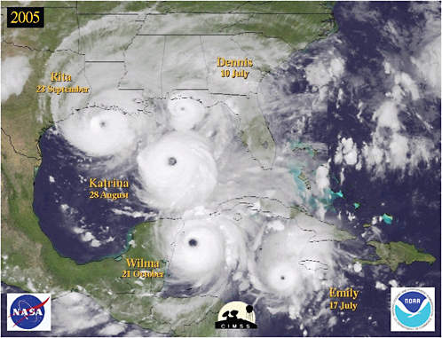
FIGURE 10.1 Hurricane season in the United States, 2005. SOURCE: Courtesy of the Cooperative Institute for Meteorological Satellite Studies.
needed to enhance decision making in many economic sectors while meeting the growing need for warnings to enable responses to extreme events.
Improvements in weather prediction require increased accuracy, reliability, and duration of forecasts with finer spatial and temporal detail for a wider array of weather variables. The ability to deliver new suites of user-tailored forecasts will require higher-quality satellite observations, their effective assimilation into NWP models, and better communication between data producers and user communities. The value of space-based observations will be greatly enhanced if useful new data applications are quickly made available to the government, the public, and the private sector—an improvement that will require an enterprise-wide effort to dramatically shorten the current 20-year delay between the availability of research results and their transition into applications. Rapid infusion of technology into operations and decision support will require improved communication and partnerships among the weather-observation agencies, the university modeling community, and users (NRC, 2000, 2003a,b).
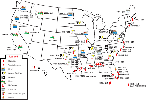
FIGURE 10.2 Billion-dollar weather disasters, 1980 to 2005. Of the 67 weather-related disasters indicated, 55 occurred during or after 1990. Total costs for the 67 events have been estimated at more than $500 billion based on an inflation/wealth index. The economy’s dependence on the effects of weather demands continuing improvements in forecasting capability. SOURCE: Courtesy of NOAA National Climatic Data Center.
Achieving those results will require an integrated, vigorous, targeted program of research, technology development, measurements, and monitoring. The roadmap for such a program will include obtaining and using new knowledge to improve existing forecasts, developing new suites of forecasts, and anticipating and mitigating the effects of natural and human-induced hazards through the use of new and more reliable information. The roadmap also envisions fully leveraging multiagency, multisector commitments and expertise to accelerate the transition of research into operations for beneficial uses by decision makers and the public (NRC, 2000, 2003a,b). By 2025, use of a growing weather database will be as common as use of the Global Positioning System (GPS) is today.
SATELLITE-SYSTEM STATUS AND STRATEGY FOR 2015–2025
Weather is crucial to all societal and economic activities and has no geographic boundaries. Since the beginning of the space age, the operational and research weather satellites of NOAA, NASA, and DOD have served the diverse weather community well. The United States shares vast amounts of satellite data with international partners daily. Global exchange and exploitation of satellite data is a long-standing hallmark of the international weather community.
The efforts of climate, hydrologic, oceanographic, and other research communities benefit from the work of the weather science and applications community (NRC, 2004), which spans traditional weather forecasting (e.g., clouds and rain), chemical weather (e.g., air pollution), and space weather (e.g., solar-induced communication interference). All of those research communities thus share a dependence on satellite weather observations as a primary source of data. The advances in scientific understanding and forecast capability during the four decades since the introduction of satellite meteorology have been remarkable, but further dramatic improvements will require obtaining currently unavailable satellite weather observations during the next two decades (Box 10.1). This section outlines the current status of and weaknesses in the satellite system, priorities for improvements, and an implementation timeline and lists the panel’s recommended tropospheric-, chemical-, and space-weather measurements for enhanced space-based observations needed to ameliorate analysis deficiencies and improve both numerical and human weather prediction. Those measurement missions are discussed in some detail in the section “Priority Weather Observations and Missions” below.
The panel’s approach to advance weather science and applications from space draws on a proven foundation of increasingly capable global observing systems, modeling systems, and theoretical and computational advances. As satellite observations have progressed during the last 45 years, so also have data assimilation, numerical weather-modeling capabilities, and theoretical understanding of weather processes. In the last 10 years, the community has been building important new data-assimilation tools to optimize use of global observing data sets. The United States—with leadership from NASA, NOAA, the Naval Research Laboratory, and the weather science research community—is well positioned to continue to exploit the opportunities of the future. However, organizational challenges remain. For example, NASA and NOAA are not well organized to develop new science missions to continue advancing weather science and applications from space. Accordingly, the panel recommends creation of a NASA-NOAA Earth Science Applications Pathfinder (ESAP) program that would allow all special missions or instrument flights to quickly take advantage of new capabilities to realize Earth science societal and economic applications, moving from research into operations.
|
BOX 10.1 HURRICANE PREDICTION Weather prediction has advanced greatly during the last few decades. Improvements in global observing systems, advances in data assimilation and numerical modeling,and higher efficiency and capacity of computing resources have all contributed to higher reliability of and increased public confidence in weather forecasts. However, weather analysis and forecasting have not matured to the point where important gains are no longer achievable. Although the 2005 Atlantic hurricane season included some remarkably good forecasts (e.g., Katrina, 3 days before landfall near New Orleans), it also included examples of highly uncertain predictions that resulted in considerable social and economic distress for regions of the southern U.S. coast. For example, the forecast that Hurricane Rita would make landfall near the Galveston-Houston area prompted major evacuations of those communities; the storm actually made landfall to the north of that region with little damage or impact in the two evacuated cities. Hurricane Wilma (Figure 10.1.1) is another striking example of hurricane-forecast uncertainty during the 2005 season. The major numerical models from October 21 agreed on Wilma’s forecast track direction and on a landfall on the south Florida coast, but there were major differences in timing (along-track error). That type of uncertainty is not always solved by consensus or ensemble approaches and leads to low forecaster confidence. The forecasts of Wilma’s eventual impact on south Florida that were provided to the public and emergency managers in charge of evacuation were highly uncertain and led to mass evacuations many days in advance of what was ultimately necessary, with great economic loss. The primary cause of the numerical-model forecast uncertainty was the timing of the interaction of an approaching midlatitude trough with Wilma’s steering flow. The amplitude and speed of the upper-level trough as it left the southwest United States (a radiosonde data-rich region) and entered the Gulf of Mexico (lacking in radiosondes) were uncertain. Special dropsondes released from the NOAA Gulfstream IV aircraft supplied limited observational sampling of the region, but in analysis-sensitive regions like this one continuous assimilation of data is necessary to reduce initial analysis errors substantially and improve the numerical-model forecasts. 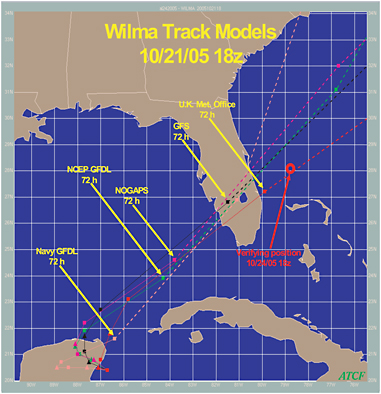 FIGURE 10.1.1 An example of along-track scatter of the numerical models for the Hurricane Wilma forecast highly relevant to the timing of the landfall in south Florida. |
Current Satellite System and Near-Term Ramp into 2015–2025
The United States enjoys a successful and well-recognized weather-satellite program. NOAA and NASA have implemented both polar and geosynchronous operational satellite programs that serve a broad spectrum of users. NASA’s completed Earth Observing System (EOS) provides new research results and important new capabilities that could be transitioned into NOAA operational programs. NASA’s Earth System Science Pathfinder (ESSP) program will provide important new space observations. DOD also operates weather satellites and shares the data with the larger weather community.
Approved continuations and upgrades of the current satellite system are key factors in preparing for the observations for Earth science and applications from space recommended for the decade 2015–2025. In developing its own recommendations, the panel assumed that the NOAA-NASA GOES-R and NOAA-DOD-NASA NPOESS programs would go forward with the current planned instrument complement, including CMIS or a similar instrument on NPOESS, but recognizing the deletion of the Hyperspectral Environmental Suite (HES) for at least the early flights of the GOES-R, -S, -T, and -U series. The deletion of the hyperspectral IR sounder portion of HES is addressed below. The Weather Science and Applications Panel assumed the continued success of NASA’s Aura (launched in July 2004 with 6 years of planned life), CloudSat (with 2 years of planned life), and CALIPSO (launched in April 2006 with 3 years of planned life), as well as the continuation of the Taiwan-U.S. COSMIC mission (launched in April 2006; Cheng et al., 2006).
During the next three decades, results from those key missions and the Block 2 NPOESS follow-on will play a central role in key Earth science and applications focus areas, including observations of weather, climate, atmospheric composition, water, human health and security, and oceanography. Analysis and application of the results from recently launched missions and missions due for launch in the period 2007–2014 will provide a strong foundation to guide the implementation of the high-priority missions recommended for the period 2015–2025.
In developing its recommendations for future missions, the panel noted that planned follow-on missions are at serious risk. For example, NPOESS was recently restructured to reduce costs, and many capabilities were reduced or eliminated. Space weather measurement capabilities from DMSP F16 and beyond were cut, and climate measurements were eliminated. Despite strong support for the Global Precipitation Measurement (GPM) mission in the decadal survey committee’s interim report (NRC, 2005), which specifically recommended that GPM be launched without delay, NASA has announced another delay in this key weather and climate mission. An international effort to provide more accurate and frequent precipitation measurements, GPM would build on the success of the Tropical Rainfall Measuring Mission (TRMM) to address a critical societal need. With growing demand for water and awareness of the impact of drought on society, the need to better understand the water cycle and means for ensuring the availability of water are of critical concern to all nations The panel thus reiterates in the strongest terms the decadal survey committee’s recommendation that GPM be flown as quickly as possible.
GOES-R does not include an operational coronagraph designated as a planned product improvement for possible future GOES missions, and there is no operational follow-on to the critical L1 solar wind measurements being made by ACE. Moreover, the GOES-R HES has been replaced with a GOES sounder to be determined. Measurements from the Atmospheric Infrared Sounder (AIRS) on NASA’s polar-orbiting Aqua satellite showed that better geosynchronous Earth orbit (GEO) vertical soundings than those currently available from GOES are essential for improved weather forecasting (Le Marshall, 2005). Moreover, the sampling from polar-orbiting satellites is too small for observing and adequately predicting the rapidly changing atmospheric conditions that lead to severe weather, including tornados, flash floods, and hurricanes (including intensity and landfall prediction).
The Geosynchronous Imaging Fourier Transform Spectrometer (GIFTS), or instruments of similar capability with newer technology, can provide the needed soundings. Developed under NASA’s New Millennium Program, GIFTS was designed to obtain 80,000 closely spaced horizontal (about 4 km), high-vertical-resolution (about 1–2 km) atmospheric temperature and water vapor profiles every minute from geostationary orbit.1 Because of budgetary considerations, resulting partly from the Navy’s withdrawal of support for a spacecraft and launch vehicle, NASA discontinued funding for GIFTS beyond FY 2005.
Therefore, the panel recommends that NASA complete the space qualification of a hyperspectral sounder and ensure its flight early in the 2010s and that NOAA ensure that the ground-based processing system is ready for demonstration. The panel further recommends the transition from demonstration to operational capability by 2018. The demonstration and transition to operational GEO hyperspectral soundings could be made within the NASA-NOAA ESAP program recommended above. In the section “Priority Weather Observations and Missions” below, the panel recommends flights of an all-weather GEO sounder and a GEO chemistry mission. Together, these three flights would form a robust and synergistic GEO “carousel”—similar to the low-Earth-orbit (LEO) A-Train—bounded by the GOES-East and GOES-West satellites.
The challenge is to combine the NPOESS and GOES missions with the NASA research missions and the international satellite missions to deliver the observations and products required by society. NPOESS requires about 30 to 40 percent (and GOES another 5 to 10 percent) of the annual U.S. expenditures of about $2.5 billion for Earth science and applications missions. The NPOESS program will be a working example of interagency and community interaction leading to the transition of research to operational applications for societal and economic benefit. A vision of the weather and related sciences without a central role for NPOESS and GOES would be incomplete. NPOESS and GOES-R should maintain their requirements and objectives and carry their full complement of advanced technology instruments even if some are delayed. Otherwise, the weather data sets and recommended vital missions for Earth science and applications for 2015–2025 will be crippled.
Baseline R&D and Observation Strategy for 2015–2025
In developing a baseline R&D and observational strategy for 2015–2025, the panel drew on many sources of information. In response to the decadal survey committee’s RFI, the community provided more than 75 thoughtful weather-related responses (see Appendixes D and E). Further expert knowledge of the new challenges for weather science and applications was provided through agency roadmaps and through published National Research Council studies on research and technology planning. Agency scientists and leaders provided the panel with considerable information in discussions and presentations. The panel is also aware of needs in and plans of the private sector.
New challenges are central to the development of a research and observational strategy for weather science for the decades ahead. Key physical, dynamical, and chemical processes associated with severe weather (e.g., hurricanes and tornados) are neither fully understood nor characterized, and so high priority is placed on measurements that will contribute to successful forecasting of such events. Key processes in which further observations are needed to advance understanding include the genesis and evolution of strong midlatitude and tropical storms, major summertime precipitation systems, air-pollution events, and global chemical-weather characteristics. Research and operational forecast systems do not currently include all the processes or observations necessary to understand and predict the full range of weather systems. For example, the interactions between the chemical and physical properties of condensation
nuclei aerosols and cloud water and ice, with the ensuing formation of a variety of precipitation patterns, are not adequately understood, modeled, or predicted. Improving air-quality forecasts on regional to global scales will require furthering the understanding of the complex interactions among sources, sinks, transport, and chemistry of tropospheric gases and aerosols. Furthering that understanding will require advances in space-based observations. In the realm of space weather, many magnetoelectrodynamic processes are not well understood. Initiation of solar flares and coronal mass ejections, geomagnetic storm physics, and basic mechanisms of ionospheric irregularity formation and propagation require substantial measurement and research before forecasting requirements can be met.
Shortfalls in knowledge about key weather events and processes place the United States in a position where it cannot meet the increasing requirements for improved predictions of major weather storms, events, and processes. Moreover, the growing complexities of society and long-term population growth and movements have increased vulnerability to damaging weather events. A considerable body of research provides clear directions for adapting to and mitigating high-impact events through improvements in forecasts.
PRIORITY WEATHER OBSERVATIONS AND MISSIONS
To determine priorities for weather observations and missions, the panel considered the RFI responses and presentations by leaders in the community. Evaluations were based on potential to transform science, promote societal applications, and advance forecasting and on risk, readiness, and cost. The panel also considered the ability of proposed measurements to address international or national plans and to address the goals of the Global Earth Observing System of Systems (GEOSS).2 The process led to identification of the key applications and societal benefits, key science themes, and key satellite observations listed in Box 10.2 and to the conceptual missions proposed in the discussions below on tropospheric-weather measurements, chemical-weather measurements, and space-weather measurements.
The conceptual missions include tropospheric wind measurements; all-weather measurement of temperature and humidity profiles, including surface precipitation and sea-surface temperature; an operational radio occultation system for high-vertical-resolution, all-weather temperature and water vapor profiles; aerosol and cloud property observations; an air-pollution monitoring system with high temporal resolution; comprehensive tropospheric aerosol characterization; comprehensive tropospheric ozone measurements; and a suite of space-weather instruments consisting of a solar monitor, an ionospheric mapper, and a system of “space-weather buoys” implemented through a constellation of magnetosphere microsatellites. The GPS radio occultation measurements recommended for characterizing tropospheric weather are also useful for characterizing space weather and climate and are mentioned in that subsection.
Tropospheric-Weather Measurements
The panel’s four recommended measurement missions for characterizing tropospheric weather are outlined in Table 10.1 and discussed below.
|
BOX 10.2 BENEFITS, KEY SCIENCE THEMES, AND REQUIRED SATELLITE OBSERVATIONS FOR WEATHER Societal Benefit
Science Themes
Required Satellite Observations
|
Tropospheric Winds
Mission Summary—Tropospheric Winds
|
Variables: |
Vertical profile of horizontal winds |
|
Sensors: |
Wind lidar (preferred), scatterometer, Molniya imager |
|
Orbit/coverage: |
LEO/global |
|
Panel synergies: |
Climate, Health, Water |
The panel began by identifying, from the viewpoint of the weather science and applications community, the current capabilities and projected requirements for observations of the vertical profile of horizontal winds. The correct specification and analysis of tropospheric winds is an important prerequisite for accurate NWP. Despite recent advances in assimilation of radiances, improved accuracy and resolution of wind-profile data remain essential requirements for improved NWP because of its unique role in specifying the initial potential vorticity, which is a key dynamic property that is a major determinant of atmospheric evolution. The value of accurate wind measurements in day-to-day weather forecasting is well established.
TABLE 10.1 Weather Panel Summary of Priority Tropospheric-Weather Measurement Missions
|
Summary of Mission Focus |
Variables |
Type of Sensor(s) |
Coverage |
Spatial Resolutiona |
Frequencya |
Synergies with Other Panels |
Related Planned or Integrated Missions |
|
Tropospheric winds (three options) |
Vertical profile of horizontal winds |
Wind lidar (preferred option) |
Global |
350 km horizontal, 1 km vertical |
TBD |
Climate Health Water |
3-D Winds |
|
|
Ocean-surface vector winds |
Scatterometer |
Global |
20 km |
6–12 hr |
|
NPOESS |
|
|
Water vapor tracked winds |
Molniya imager |
Northern Hemisphere |
2 km IR/WV imagery, 1 km visible imagery, ~25 km vector spacing |
15 min during 8-hr apogee dwell |
|
|
|
All-weather temperature and humidity profiles |
Temperature, humidity profiles in clear and cloudy conditions; surface precipitation rate; sea-surface temperature |
Microwave array spectrometer; precipitation radar |
Regional or global |
25 km (humidity and precipitaton rate), 50 km (temperature) horizontal, 2 km (humidity and temperature) vertical |
15–30 min |
Climate Health Water |
PATH |
|
GPM |
|||||||
|
Radio occultation |
Temperature, water vapor profiles |
GPS |
Global |
~200 m vertical |
~2,500/day |
Climate Health Water |
GPSRO |
|
Aerosol-cloud discovery |
Physical, chemical properties of aerosols; influence of aerosols on cloud formation, growth, reflectance; ice, water transitions in clouds |
Multiwavelength aerosol lidar, Doppler radar, spectral polarimeter, A-band radiometer, Submillimeter instrument, IR array |
Global |
200 m vertical |
TBD |
Climate Health |
ACE |
|
aColumn entries are targets based on a current assessment of expected future mission performance capability. Further, more detailed studies may be warranted. |
|||||||
For example, the path and intensity of tropical cyclones are modulated by environmental wind fields (see Box 10.1). Reliable global observations of winds are also needed to improve scientific understanding of atmospheric dynamics, the transport of air pollution, and climate processes.
Both scientific and forecasting applications are severely limited by the lack of data on the vertical profile of the horizontal winds over the oceans, the tropics, and in the Southern Hemisphere, where radiosonde observations are scarce. Surface wind observations (from anemometers and scatterometers) and single-level upper-air wind observations (from aircraft and cloud-drift winds) can provide only partial wind information over data-sparse regions.
Satellite sounders provide good global coverage of microwave and infrared radiances, which can be assimilated directly for an accurate definition of temperature and humidity profiles. When that information is coupled with surface pressure information, the midlatitude wind field can be estimated with approximations of geostrophic and hydrostatic balance. In the tropics, however, geostrophic approximation is less valid, and direct measurements of the wind are required to produce accurate analyses of atmospheric flow. In the extra-tropics, wind data are important for identifying intense small-scale features, such as jet streaks, which involve strong departures from geostrophic balance. Because wind is ultimately related to the transport of all atmospheric constituents, its measurement is also crucial for improving understanding of the sources and sinks of constituents, such as atmospheric water, carbon, trace gases, and aerosols.
In summary, despite the recent advances and sophistication of modern data-assimilation methods, large analysis uncertainties remain over wide areas of the globe, especially for the three-dimensional tropospheric wind field. More accurate and reliable and longer-lead-time weather forecasts, driven by fundamentally improved tropospheric wind observations from space, would have directly measurable societal and economic impacts. To identify and achieve an improved tropospheric wind-observing system by 2025, the weather panel recommends a phased approach that builds on the existing observing system, addresses major gaps, and sets priorities among activities on the basis of technical readiness and potential impact.
Phased Implementation of a Doppler Wind Lidar System (2015–2025)
A hybrid Doppler wind lidar (HDWL) in low Earth orbit (LEO) could dramatically improve weather forecasts (Baker et al., 1995; Atlas, 2005) by making global measurements of the wind profile through the entire troposphere and into the lower stratosphere under a wide variety of aerosol loading conditions (Box 10.3). In recognition of the importance of wind-profile data, the Panel on Water Resources fully concurs with the weather panel’s recommendation that a lidar horizontal wind profiling mission should have top priority.
Owing to the complexity of the technology associated with an HDWL, the panel strongly recommends an aggressive program to design, build, aircraft-test, and ultimately conduct space-based flight tests of a prototype HDWL. The panel recommends a two-stage space-implementation approach. The two stages, discussed below, depend heavily on an aggressive and continuing technology-development program that supports both the coherent and the noncoherent Doppler wind lidar (DWL) techniques and all other technologies necessary for implementation of the HDWL operational demonstration mission.
-
Stage L Because the European Space Agency (ESA) demonstration of a one-component wind lidar measurement with the noncoherent DWL technique does not address all the relevant techniques and technologies needed for the HDWL mission, the panel recommends that NASA support the development and space demonstration of a prototype HDWL system capable of global wind measurements to meet demonstration requirements that are somewhat reduced from operational threshold requirements, as described in a 2001 NOAA-NASA workshop. An HDWL demonstration mission in around 2016 should include the demonstration of a technique for the coherent and noncoherent DWLs that would enable
|
BOX 10.3 HYBRID DOPPLER WIND LIDAR The hybrid Doppler wind lidar (HDWL; Figure 10.3.1) is a combination of two separate Doppler wind lidar (DWL) systems operating in different wavelength ranges that have distinctly different but complementary measurement advantages and disadvantages. One DWL system would be based on a coherent DWL approach using a 2-µm laser transmitter and a coherent detection system. This type of system has been used extensively in ground-based Doppler lidars and more recently in a few airborne lidar systems. Because the operational wavelength of the system is in the near-infrared, the system has high sensitivity for making accurate wind measurements in the presence of aerosols, such as in the planetary boundary layer or in aerosol-rich layers in the free troposphere resulting from, for example, dust, burning-biomass plumes, or clouds. In contrast, this type of system has low sensitivity for making wind measurements in regions with low aerosol loading, which is frequently found in the free troposphere and above the tropopause. The second DWL component of the HDWL system is the noncoherent (direct) DWL, which operates at ultraviolet wavelengths and uses the noncoherent (or direct) detection of the molecular Doppler shifts to enable wind measurements in the “clean” air regions but at a higher power cost. The technique has been demonstrated in a ground-based system, and an Instrument Incubator Program (IIP) project is under way to demonstrate it from an aircraft. The European Space Agency (ESA) has an aircraft demonstration of the technique in progress. ESA is developing the Atmospheric Dynamics Mission (ADM) Aeolus to demonstrate the capability to measure one horizontal component of the wind vector globally with a noncoherent DWL technique from space (Stoffelen et al., 2005). Aeolus may have the potential to make wind measurements from 0–20 km with vertical resolutions of 0.5 km (at an altitude of 0–2 km), 1 km (at 2–16 km), and 2 km (at 16–20 km) with accuracies of 2–3 m/sec over this altitude range and a horizontal resolution or integration of 50 km. Many developments are necessary to realize the full global two-dimensional horizontal wind measuring capability of an HDWL The panel recommends that all aspects of the HDWL be examined with respect to technical readiness and that an aggressive development program be implemented to address the high-risk components of the instrument package. This program should complement and leverage, where possible, the work being performed by ESA. 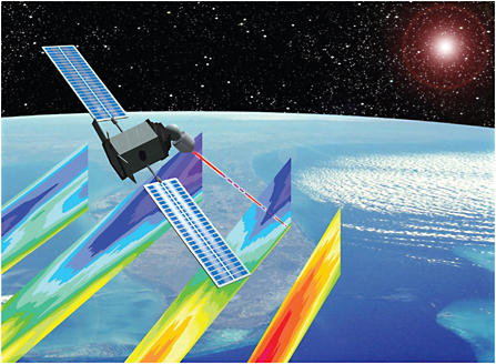 FIGURE 10.3.1 Artist’s sketch of a hybrid Doppler wind lidar. SOURCE: Courtesy of Michael Kavaya, NASA Langley Research Center. |
-
the global determination of two-dimensional horizontal winds over the entire 0- to 20-km altitude range. All technologies critical for the operational demonstration mission—including all critical laser, receiver, detector, and control technologies—need to be demonstrated in this HDWL demonstration mission.
-
Stage II. Knowledge gained from the NASA HDWL demonstration mission, the ESA noncoherent DWL demonstration mission, and the NASA DWL technology program will be used to develop and launch an HDWL operational demonstration mission. This mission will demonstrate the full range of threshold wind-measurement requirements for an operational HDWL system. The HDWL operational demonstration mission could be launched as early as 2022.
An HDWL mission will improve acquisition of global observations of wind profiles for assimilation into the latest NWP models. There will be substantial societal benefits from the mission in the form of improved weather forecasts and severe-storm predictions. There is also great potential for discovery in seasonal and interannual measurements of winds, aerosols, and clouds from the tropics to the polar regions. Wind information will have direct benefits for the security of human populations downwind of hazardous sources of gases or aerosols. It will also benefit the long-term atmospheric studies associated with climate change.
Other Near-Term Opportunities for Tropospheric Wind Measurement from Space
Scatterometer. In the near term, the weather panel strongly supports the continuation and improvement of over-ocean surface wind speed and direction observations with ocean scatterometer observations and the full-ocean surface wind objectives for NPOESS.
Feature Track Winds. More than 35 years of experience with the GOES satellites has demonstrated the value of high-temporal- and high-spatial-resolution imagery for deriving feature-tracked winds. A major limitation of the satellites flying in the classical geostationary orbit is that they provide little useful coverage of regions beyond 60–65° latitude. The recently successful assimilation of experimental tropospheric winds over the polar regions that were derived from Terra/Aqua MODIS water vapor imagery (Velden et al., 2005) has led to a renewed push from both the operational and research communities for access to timely high-latitude water-vapor imagery in the post-MODIS era. The visible-infrared imager-radiometer suite (VIIRS; the operational MODIS follow-on) under development for NPOESS does not include a water-vapor channel, because the NPOESS IORD-II does not specify a VIIRS polar-wind measurement requirement. The panel recommends that this omission be remedied in the fourth VIIRS sensor and beyond.
Molniya-Orbit Imager. A promising solution to fill the time gap between MODIS and later NPOESS imagers (which may eventually include a water-vapor channel) is to obtain polar winds in a highly inclined eccentric Molniya orbit, which has been used by Russian communication satellites since the late 1960s. That orbit offers a promising vantage point for obtaining GOES-type imagery for high-latitude regions. A satellite in this orbit, which has a 12-h period, hovers nearly stationary over the high latitudes for about 8 h. In addition to the winds product, a Molniya-orbit imager has numerous other applications, including monitoring and “nowcasting” of intense weather systems, sea-ice tracking and model validation, snow cover and albedo monitoring, water quality monitoring, volcano monitoring and aviation safety, wildfire monitoring, air-quality monitoring, contrail-cirrus studies, cloud physics, and soil vegetation atmosphere transport model verification. A Molniya-orbit imager mission that includes a six-channel visible-IR imager with GOES-R-class horizontal resolution and image quality and real-time data-dissemination capabilities could be ready for launch in about 2010–2011 (Riishojgaard, 2005). The imager would include at least two water-vapor channels. That concept is the only known mission scenario that would provide high-resolution
water-vapor imagery and wind data for the high latitudes between the end of the MODIS missions in about 2009 and the launch of a suitably equipped NPOESS mission (which is unlikely before about 2019).
All-Weather Temperature and Humidity Profiles
Mission Summary—All-Weather Temperature and Humidity Profiles
|
Variables: |
Temperature, humidity profiles in clear and cloudy conditions, surface precipitation rate, sea-surface temperature |
|
Sensors: |
Microwave array spectrometer, precipitation radar |
|
Orbit/coverage: |
MEO or GEO/global or regional |
|
Panel synergies: |
Climate, Health, Water |
Here, the panel identifies, from the viewpoint of weather science and applications, the current capabilities and projected requirements for fine-temporal-resolution all-weather measurement (in both clear and cloudy regions) of temperature and humidity profiles. Because microwave technology can also measure surface precipitation rate and sea-surface temperature and is the only technology that can provide all-weather capability, the synergies of all four measurements are considered.
Severe weather systems with intense rain or snow are always associated with dense and extensive cloud systems that are essentially opaque to the infrared and visible. Current operational microwave sounders have reduced profiling capabilities in those weather systems, but it is in them that the weather science and applications communities most need detailed all-weather profiles of temperature and humidity to gether with measurements of surface precipitation rate. Over the midlatitudes of the United States and other midlatitude regions, severe weather involving extensive flooding, snowfall, or convective events with hail, tornados, and local flash floods always occurs beneath a mass of largely opaque clouds. Likewise, the genesis and intensification of hurricanes always occur beneath and within a mass of largely opaque clouds.
A capability for detailed all-weather profiles of temperature and humidity with surface precipitation rate would certainly improve forecasting of the genesis, tracks, and intensity changes of hurricanes and the geographic distribution and magnitude of associated intense rainfall and storm surges. The need for information about flood and storm-surge intensity during and after hurricane landfall is underscored by the unprecedented extent and intensity of the 2005 hurricane season in the United States. If all-weather profile observations from space of the type just described had been available during that devastating period, more accurate and reliable long-lead forecasts probably would have reduced the loss of life and the suffering.
Soundings of the three-dimensional atmospheric temperature and humidity profiles, under all-weather conditions, with surface precipitation measurements every 15–30 min, would enable substantial improvements in forecasts. Besides improving the definition of the state of the atmosphere at the beginning of a forecast, the availability of such an observational data set would have an enormous impact on the understanding of weather processes and dynamics. The inadequacies of current NWP models in representing the processes of cloud formation, evolution, and precipitation are widely recognized. Frequent all-weather observations of the kind described will provide vital new information on how to model crucial cloud and precipitation processes in the planetary boundary layer through the depth of the troposphere and result in more accurate numerical forecasts of severe weather.
Sea-surface temperature strongly affects global transfer of moisture and sensible heat to the atmosphere. Hurricane genesis and intensification over the tropical oceans are extremely sensitive to sea-surface temperature. Recent results from TRMM and other missions confirm that at moderate wind speeds, surface winds and lower-atmosphere humidity are responsive to sea-surface temperature perturbations. There is a clear need for cloud-independent sea-surface temperature measurements. Furthermore, understanding
and forecasting of El Niño and La Niña events require the all-weather measurement of both sea-surface temperature and atmospheric conditions far beyond present capabilities.
Current Capabilities and Projected Needs for All-weather Observations
All-weather, space-based retrievals of profiles of air temperature and water vapor, together with surface precipitation rate and sea-surface temperature, require observations in the microwave region of the spectrum. Infrared observations are a useful alternative for temperature and humidity in clear skies, but infrared profiles are contaminated or blocked by clouds and cannot directly sense precipitation.
Imaging the complete Earth at a refresh rate of 15–30 min can, in principle, be achieved from a number of Earth orbits. Current and planned future low-Earth-orbiting (LEO) assets—such as the AMSU, SSMI/S, and CMIS microwave spectrometers—are capable of retrieving temperature and humidity profiles and column-averaged precipitation on a global scale. They will provide the new all-weather sea-surface temperature information.
However, the temporal resolution from LEO cannot approach 15–30 min without an impractically large constellation of platforms. Only medium and geosynchronous Earth orbits (MEO and GEO) can reasonably deliver the required time resolution. Accommodation of an all-weather sensor suite on future GOES GEO platforms is one option. The GOES I-M Visible/IR imagers have demonstrated the value of subhourly image-refresh rates for many applications. Adding a microwave spectrometer would expand GOES coverage to include cloudy cases, would permit the direct sensing of precipitation, and would generally enable the societal benefits noted above. MEO platforms are a second option. The lower orbit altitude would improve spatial resolution relative to GEO. But MEO remote sensing is a new approach with attendant technical uncertainty, and its risks and benefits must be weighed accordingly.
Temperature and Humidity Profiles with Surface Rain Rate
All-weather retrievals of air-temperature and absolute-humidity profiles require spectrometric observations of microwave emission along rotational transition lines of oxygen and water vapor. The lower energy transitions, in particular in the 50- to 70-GHz and 118-GHz oxygen complex and the single 183-GHz line for water vapor, are best suited for penetration into clouds. Those observations have not been obtained from a MEO or GEO platform, and so the effort would require new sensor development. Several competing engineering approaches are being developed to achieve that objective. They are deemed to be of sufficient technical maturity to warrant consideration as a new-start space mission in about 2010. Selection between the competing engineering approaches should be made with a peer-review or competitive selection process.
Frequent measurements of precipitation profiles require an active microwave (radar) sensor. The LEO-based TRMM precipitation radar was the first such space-borne instrument. A MEO or GEO version of the TRMM radar would be needed to meet the 15- to 30-min temporal sampling requirement. The technology readiness level of such a sensor is still too low. The panel encourages continued development of the technology necessary to mount precipitation radars on MEO or GEO platforms.
The panel recommends, as a gap-filling alternative, the retrieval of surface rain rate (as opposed to precipitation profiles) with passive microwave observations, as demonstrated with SSM/I (Ferraro, 1997), TRMM (Kummerow et al., 2001; Bauer et al., 2001), and AMSU (Gasiewski and Staelin, 1990; Bauer and Mugnai, 2003). That method requires the same microwave spectrometer observations as the temperature and humidity profiles, and so technology readiness is considerably more mature.
Radio Occultation
Mission Summary—Radio Occultation
|
Variables: |
Temperature, water vapor profiles |
|
Sensor: |
GPS |
|
Orbit: |
LEO |
|
Panel synergies: |
Climate, Health, Water |
In an advanced data-assimilation system, simultaneous availability of radio occultation (RO) measurements and microwave spectrometer profiles of temperature and water vapor from MEO or GEO would synergistically deliver substantially improved accuracy, precision, vertical resolution, and global coverage of temperature and water vapor. A constellation of small satellites providing RO soundings would complement the horizontally well-resolved microwave spectrometer soundings by adding independent, accurate, and high-resolution vertical soundings in all weather on a global basis (including over the polar regions, where soundings from MEO, but not from GEO, are possible).
RO3 (sometimes termed GPS-MET), a new satellite global observing approach, is a low-risk, inexpensive, high-payoff technology to obtain key information about temperature and moisture profiles in the lower stratosphere and the troposphere above the boundary layer with total electron content in the ionosphere.4 It has the potential to advance understanding of atmospheric thermodynamics, stratosphere-troposphere exchange, and ionospheric structure and behavior and to make a major contribution to improvement in regional and global weather forecasting, space-weather forecasting, and climate benchmark observations. Thus, it provides excellent societal and economic benefits for a relatively low cost (about $10 million to $20 million per year, when spread over the 5–6 years of a mission).
Four successful RO space experiments have been flown.5 The joint U.S.-Taiwan Constellation Observing System for Meteorology, Ionosphere and Climate (COSMIC; see http://www.cosmic.ucar.edu/), which has orbited a six-satellite constellation with both science and real-time forecasting applications and is expected to last from 2006 to 2011, is the most recent and extensive of them.
An operational RO system would comprise a small constellation of small satellites carrying precision, space-qualified GPS receivers and supporting technology. The system would complement and add special capabilities (such as tropopause height detection) to the microwave and infrared temperature and moisture profilers on the U.S. operational polar orbiters (DMSP, NOAA, and NPOESS). The system would also greatly enhance an independent but closely related RO system planned by Europe on MetOp. A U.S. operational constellation of about six satellites would add more than 2,500 RO soundings per day to the GEOSS. When the European Galileo constellation is in place, the number of RO soundings obtained from a single LEO platform will roughly double with no cost increase. Alternatively, with Galileo the number of spacecraft carrying GPS receivers could be reduced with an associated cost decrease. COSMIC will provide data to help to determine the optimal number of RO soundings per day over the globe.
Assuming that the 5-year COSMIC mission will be completed as planned, the panel recommends a follow-on operational, long-term RO system consisting of about six satellites that will meet the needs of both science and forecasting user groups. COSMIC should be supported by well-developed and tested
ground-analysis and data-use tools, including advanced data-assimilation methods to use the satellite measurements directly in both research and forecast weather models.
Aerosol-Cloud Discovery Mission
Mission Summary—Aerosol-Cloud Discovery
|
Variables: |
Physical, chemical properties of aerosols; influence of aerosols on cloud formation, growth, reflectance; ice and water transitions in clouds |
|
Sensors: |
Multiwavelength aerosol lidar, Doppler radar, spectral polarimeter, A-band radiometer, submillimeter instrument, IR array |
|
Orbit/coverage: |
LEO/global |
|
Panel synergies: |
Climate, Health |
Some mission concepts were regarded as having high priority by several panels, including the weather panel. This panel’s top priority is a science mission to understand the linkages among clouds, aerosols, and Earth’s hydrologic cycle. The Aerosol-Cloud Discovery (A-CD) mission also addresses the high-priority aerosol and cloud measurements needed for improved understanding of climate change and of hydrologic processes.
As noted in this chapter’s “Overview” section, a key unknown is the complex and variable interaction of natural and anthropogenic aerosols with Earth’s clouds and precipitation events. The issue is important because aerosols serve as nuclei for cloud particles: the physical and chemical properties of aerosols affect the growth of cloud particles to precipitation-size droplets, the abundance or scarcity of aerosol can influence cloud reflectance, and heating by dark aerosols can support cloud formation. Knowledge of those interactions is poor. New measurements and knowledge of cloud-aerosol interactions is required in the period 2015–2025 to improve the accuracy of hydrologic forecasts of severe weather and reduce the uncertainties in climate-change estimates. An important further requirement of the mission is new knowledge regarding ice and water transitions in clouds, to be provided by new global measurements of the distribution of ice-water path and weighted mean mass particle diameter. Those global ice measurements should have the temporal and spatial sampling required for accurate regional-seasonal averages and assimilation into global systems to guide improvements of ice-cloud representation and precipitation processes in global Earth-system models. Decisions regarding important environmental issues—such as global and regional weather and air-pollution events, climate, and freshwater management—will certainly benefit from both types of new knowledge.
The A-CD could be embarked on a free-flyer or be added to the instrument complement of approved missions that have not yet flown, such as GPM and NPOESS. The proposed A-CD instrument complement includes a multiwavelength aerosol lidar for determining the vertical distribution of aerosol properties. The lidar could be a multiwavelength high-spectral-resolution lidar (HSRL), which has been shown to provide direct profile measurements of aerosol backscatter and extinction (Sroga et al., 1980; Grund and Eloranta, 1991) and aerosol microphysical parameters (Müller et al., 2002; Böckmann et al., 2005), or a multiwavelength, multibeam backscatter lidar, provided that this approach can be validated for determining the profile of aerosol properties, particularly in the vicinity of clouds. A multifrequency Doppler radar is also needed on the mission for determining cloud content and vertical motions. The lidar and radar would complement passive measurements of the same cloud-aerosol fields from a spectral polarimeter and an A-band radiometer. Two additional instruments are required for the ice-phase measurements; the primary instrument measures at submillimeter wavelengths (183–874 GHz) to determine ice path, and the second is an IR array that observes ice-water path to improve integrated water-path retrievals while
providing cloud height. The active-passive approach of the mission has a strong theoretical and practical application foundation.
Because the panel has included a global tropospheric aerosol mission among its priorities for chemical-weather measurements, there would be strong cross-ties between A-CD and other decadal survey panels’ areas of interest. A-CD would strongly support improved forecasting of large and small precipitation events and address key climate science questions. It would also complement proposed Japanese and European missions and add to the understanding of international, long-term global records of aerosol, cloud properties, and precipitation.
Chemical-Weather Measurements
“Weather” is commonly understood to comprise tropospheric variations of temperature, wind, clouds, and rain, but chemical weather refers to the atmospheric variation of pollutants, such as aerosols and smog, that affect health, safety, commerce, and climate. Since the Industrial Revolution, chemical weather has become more complicated and important to understand, monitor, predict, and even control through local, regional, national, and international policies and actions. Chemical weather can affect weather patterns and, perhaps less urgent but more important, can affect long-term (climatic) trends of severe weather.
The weather panel believes that the chemical-weather missions it recommends are critical for improving the understanding of and ability to monitor and predict chemical weather and its effects on tropospheric weather and climate. The panel recognizes that NOAA and EPA strategic plans have given high priority to the understanding and prediction of chemical weather with respect to both gases and aerosols. The panel identified three high-payoff missions to produce important measurements to improve the understanding and forecasting of chemical weather with both immediate and long-term societal benefits: a high-temporal-resolution air pollution mission, a comprehensive tropospheric aerosol characterization mission, and a comprehensive tropospheric ozone mission (Table 10.2).
The three missions are independently important but also highly synergistic in that they provide information on different temporal and spatial scales that together promise revolutionary improvement in knowledge and predictions of chemical weather. They will also have a substantial influence on several other decadal-survey themes—Earth science and societal benefits, by quantifying pollution emissions and assessing air quality (Box 10.4) and by determining aerosol characteristics that directly affect human health; human health and security, by improving air-pollution forecasts for sensitive populations, thereby improving air-quality forecasts in general; and climate variability and change, by improving knowledge of ozone and carbon budgets and air-pollution forcing of climate and by relating aerosol and cloud characteristics to radiation budgets and precipitation.
High-Temporal-Resolution Air Pollution
Mission Summary—Air Pollution
|
Variables: |
Tropospheric column ozone, SO2, NO2, formaldehyde, aerosols; CO with vertical sensitivity |
|
Sensors: |
UV-VIS and SWIR-IR spectrometer imagers |
|
Orbit: |
GEO |
|
Panel synergies: |
Climate, Health |
Because of the rapidly changing spatial distributions of primary and secondary pollutants in the planetary boundary layer (PBL) and free troposphere, a mission to continuously monitor air pollution in the lower troposphere across large continental regions would for the first time measure chemical weather on geographic
TABLE 10.2 Weather Panel Summary of Priority Chemical-Weather Measurement Missions
|
Summary of Mission Focus |
Variables |
Type of Sensors |
Coverage |
Spatial Resolutiona |
Frequencya |
Synergies with Other Panels |
Related Planned or Integrated Missions |
|
Air pollution |
Tropospheric column ozone, SO2, NO2, formaldehyde, aerosols; vertically resolved CO |
UV-visible, SWIR-IR spectrometer imagers |
Regional (FOV >5,000 km) |
5 km horizontal |
less than 1 h |
Climate Health |
GEO-CAPE |
|
Tropospheric aerosol characterization |
Aerosol extinction profiles, real refractive index, SSA; aerosol optical depth, size distribution, size-resolved real refractive index, nonspherical particle fraction in troposphere |
Multiwavelength lidar; along-track, cross-track multiangle passive polarimeter imager |
Global |
~150 m vertical, 20 km horizontal |
3 days |
Climate Health |
ACE GACM GEO-CAPE |
|
Glory |
|||||||
|
Tropospheric ozone measurements |
Tropospheric ozone; ozone precursors; pollutant and trace gases (CO, NO2, CH2O, SO2); aerosols; CO with day-night, vertical sensitivity |
UV-visible spectrometer; SWIR/IR spectrometer; future ozone-aerosol lidar |
Global |
Various: columns for ozone, ozone precursors in first phase with some vertical resolution for CO; <2 km vertical for ozone, 150 m for aerosols with lidar in second phase |
|
Climate Health |
GACM |
|
GEO-CAPE |
|||||||
|
aColumn entries are targets based on a current assessment of expected future mission performance capability. Further, more detailed studies may be warranted. |
|||||||
|
BOX 10.4 SMOG Major pollution episodes can result from a mixture of hydrocarbons and nitrogen oxides emitted from automobiles and industrial activities in many urban areas across the world. Conditions like that shown in Figure 10.4.1 are common in major metropolitan centers under slow-moving summertime high-pressure conditions; however, predicting the level of pollution associated with ozone and particulates is extremely difficult. The impact on the suburbs and regions downwind of the urban centers is even more difficult to forecast. The problem is exacerbated by the lack of knowledge of the composition of the air upwind of the city. Long-range transport of ozone precursor gases from other regions or continents can change the initial conditions for pollution formation and make forecasting pollution still more difficult. Space-based measurements of ozone,ozone precursors, aerosols, and other pollutants with high spatial and temporal coverage over North America, with more general coverage globally, can revolutionize the ability to predict pollution episodes. Improved forecasts will provide the critical time needed to mitigate the effects of the pollution on human health and activities and other socioeconomic effects on animals, plants, property, and businesses. 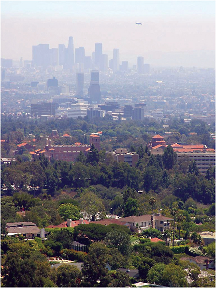 FIGURE 10.4.1 An example of a pollution event observed in Los Angeles, California, on August 10, 2003. SOURCE: Photo courtesy PDPhoto.org. |
scales necessary to develop effective policies to maintain good air quality. The weather panel identified that mission as its highest-priority chemical-weather mission for the decade 2010–2020. The mission was also identified by the Community Workshop on Air Quality Remote Sensing from Space (Edwards et al., 2006) as its highest-priority air-quality mission. The critical need for the mission has been endorsed by the international atmospheric-chemistry community in the Integrated Global Atmospheric Chemistry Observations (IGACO) theme of the Integrated Global Observing Strategy (IGOS) (IGACO Theme Team, 2004).
The weather panel and the air-quality workshop concluded that the needed fine spatial- and temporal-resolution measurements to assess and predict regional to global air quality require a geostationary orbit (GEO), where the constraints on the measurements are much less than those in the more distant Lagrangian (L-1) orbit. Moreover, some measurements could be made diurnally from GEO to examine regional transport and chemical transformations.
The measurements required of this GEO mission include tropospheric column ozone (O3), sulfur dioxide (SO2), nitrogen dioxide (NO2), formaldehyde (CH2O), and scattering and absorbing aerosols (Box 10.5). Column measurements of O3, SO2, NO2, CH2O, and aerosols are needed during the day. The instrumentation must have the capability for high O3 sensitivity down to the surface, including the PBL. In addition, daytime total column measurements of carbon monoxide (CO) are needed, along with day and night measurements in the free troposphere. To capture the local to regional scale variations in those air-quality characteristics, measurements are needed at hourly or greater frequency, at 5-km spatial resolution, with a minimal field of view of 5,000 km, and with an accuracy comparable with that of similar instruments now in LEO, such as the Total Ozone Mapping Spectrometer.
The combination of tropospheric column measurements of O3, SO2, NO2, CH2O, and aerosols and the vertically resolved CO distributions will provide information on pollution sources and sinks, photo-chemistry, PBL dynamics, vertical transport in clouds, and horizontal transport. The CO measurements in the free troposphere across the same geographic region will provide the continuous connection between the more comprehensive daytime measurements of the other gases and aerosols. These data sets will be assimilated into numerical models (both NWP models and chemical-transport models) to improve chemical-weather forecasting on urban to global scales. The Weather Research and Forecasting Regional Chemical Transport Model (WRF-CHEM) is the type of model under development by NOAA to produce operational chemical-weather forecasts.
Most of the needed instrumentation can be accommodated with adaptations of proven satellite instruments now operating in LEO—including the Ozone Monitoring Instrument (OMI), Scanning Imaging Absorption Spectrometer for Atmospheric Chartography (SCIAMACHY; see Box 10.5), and Measurements of Pollution in the Troposphere (MOPITT)—and thus offer relatively low technologic risk. However, a few additional critical measurements are required to provide increased sensitivity of the column CO and O3 measurements to concentrations of those gases in the PBL. Provided that the technology can be developed in the next few years for the enhanced CO and O3 column measurements from LEO, the mission could be ready for launch by about 2015.
Comprehensive Tropospheric Aerosol Characterization Mission
Mission Summary—Tropospheric Aerosol Characterization
|
Variables: |
Aerosol extinction profiles, real refractive index, SSA; aerosol optical depth, size distribution, size-resolved real refractive index, nonspherical particle fraction in troposphere |
|
Sensors: |
Multiwavelength lidar, along-track multiangle passive imager with cross-track swath |
|
Orbit/coverage: |
LEO/global |
|
Panel synergies: |
Climate, Health |
|
BOX 10.5 AIR POLLUTION Air pollution associated with O3 is strongly affected by the amounts of photochemically active nitrogen species (NOx) that are present in the ambient air. Because the amount of NO2 can be used as an estimate of the amount of NOx and since most of the NO2 is released by cars and trucks in the boundary layer near the surface, a measurement of the NO2 column from space can be used to help to forecast air-pollution episodes. The major metropolitan regions in the Northeast and California are easily detected by their high levels of NO2, as are the major cities in other regions across the United States (Figure 10.5.1). Similar composite maps of O3, CO, and aerosols can be created from space-based, low-Earth-orbit instruments. Because air pollution is highly variable in space and time, measurements of O3, NO2, CO, and aerosols are needed with high spatial and temporal resolution, and this can be done most effectively from geostationary Earth orbit. The measurements will revolutionize air-quality forecasting in a manner similar to weather satellites’ effects in revolutionizing weather forecasting. In addition, intercontinental transport of air pollution is a serious global issue, and so measurements of air pollutants and precursors with increased vertical resolution are needed globally to improve the ability to predict global air quality. 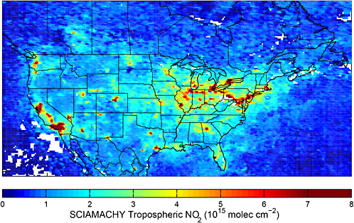 FIGURE 10.5.1 Map of NO2 column amounts across North America in July and August 2004 created from SCIAMACHY measurements on Envisat. SOURCE: Image courtesy of Randall Martin, Dalhousie University and Harvard-Smithsonian Center for Astrophysics. |
Aerosols are major contributors to local and regional air pollution, and they have important effects on human health, atmospheric chemistry, radiation budgets, cloud formation, atmospheric dynamics, and precipitation amounts. Chemical-weather objectives are dramatically affected by the composition, size distribution, and number density of aerosols in the troposphere, and aerosol properties and their effects can be forecast only with accurate and systematic global measurements. Numerical-model initialization and validation require finely resolved vertical distributions of aerosol properties. The weather panel determined that comprehensive characterization of aerosol properties could be accomplished only with a combination of polar LEO active and passive remote-sensing measurements. This mission complements the weather panel’s Aerosol-Cloud Discovery mission and the high-priority aerosol and cloud mission advocated by the Panel on Climate Variability and Change.
The measurements in this mission will be used to constrain and interpret the lower-vertical-resolution (but higher-temporal-resolution) aerosol measurements provided by the GEO air-pollution mission. The calibration of the GEO vertical aerosol measurements and the extension of this information to regions upwind and downwind of the GEO FOV and globally will provide additional critical data to improve global chemical-weather forecasting.
The aerosol properties to be measured include altitude profiles of extinction, real refractive index, single-scattering albedo with better than 1-km vertical resolution and 20-km horizontal resolution, and backscatter and depolarization with better than 150-m vertical resolution and 20-km horizontal resolution. In addition, aerosol optical depth, size distribution, size-resolved real refractive index, and nonspherical-particle fraction must be measured through the tropospheric column. These measurements must be made diurnally and globally along the ground track of a polar LEO mission. Accuracies should be consistent with the data-assimilation and validation requirements of numerical models, with special attention to the measurement of fine airborne particles with diameters less than 2.5 µm (PM2.5), which are considered to be criteria pollutants for monitoring under the U.S. National Ambient Air Quality Standards.
A comprehensive characterization of aerosol properties requires the combination of simultaneous active and passive measurements, which are practical only from LEO. The active measurements of aerosol microphysical properties can be provided by a multiwavelength HSRL technique or possibly by a multiwavelength, multibeam backscatter lidar technique, which is discussed in the section “Aerosol-Cloud Discovery” above. Passive column measurements of aerosol optical depths, single-scatter albedo, size distribution, size-resolved real refractive index, and nonspherical particle fraction can be made with an along-track, multiangle viewing technique with a large cross-track swath width (such as 800 km) to enable nearly complete global coverage (>90 percent) in less than 3 days. That would be a substantial extension of the along-track passive aerosol measurements to be made by the Aerosol Polarimetry Sensor (APS) now under development for NASA’s A-train-bound Glory mission. The combination of the active and passive measurements will allow a more direct approach for altitude-dependent speciation of aerosol properties and the integration of the results into chemical-transport models, allowing extension of the results between ground tracks and therefore providing truly global benefits.
The technology development associated with the HSRL is the primary pacing element for this mission. Although there are some similarities to the technologies contained in the Cloud-Aerosol Lidar and Infrared Pathfinder Satellite Observations (CALIPSO) mission launched in April 2006, the HSRL technique requires an advanced laser transmitter and receiver system. A proof-of-concept version has been flight tested, and a prototype of a high-power HSRL laser transmitter is being developed under NASA’s Instrument Incubator Program (IIP). This mission could be ready for launch as early as 2015.
Comprehensive Tropospheric Ozone Measurements
Mission Summary—Tropospheric Ozone Measurements
|
Variables: |
Tropospheric ozone; ozone precursors; pollutant and trace gases (CO, NO2, CH2O, SO2); aerosols; CO with day-night, vertical sensitivity; tropospheric ozone, aerosol profiles with lidar in second phase |
|
Sensors: |
UV spectrometer, SWIR-IR spectrometer, microwave limb sounder; future, ozone-aerosol lidar |
|
Orbit/coverage: |
LEO/global |
|
Panel synergies: |
Climate, Health |
Understanding and modeling tropospheric chemistry on regional to global scales requires a combination of measurements of O3, O3 precursors, and pollutant gases and aerosols with sufficient vertical resolution to detect the presence, transport, and chemical transformation of atmospheric layers from the surface to the lower stratosphere. Adequate vertical resolution is critical because of the strong vertical dependence in photochemistry and atmospheric dynamics that contribute to determining the budget of O3 and other pollutants across the troposphere and lower stratosphere. The weather panel identified comprehensive tropospheric ozone measurements as a high-priority mission to provide the needed global vertical distribution of O3, O3 precursors, and other pollutants across the troposphere and into the lower stratosphere. It also strongly complements the Panel on Human Health and Security recommendations to address air pollution and exposure to UV radiation.
The goal of the comprehensive tropospheric ozone measurement mission is to improve the understanding of chemical-weather processes on regional to global scales. To achieve that goal, the mission requires the measurement of the global distribution of tropospheric O3 with sufficient vertical resolution to understand tropospheric chemistry and dynamic processes in tropical, midlatitude, and high-latitude regions and the measurement of key trace gases (CO, NO2, CH2O, and SO2) and aerosols that either are related to photochemical production of O3 or can be used as tracers of tropospheric pollution and dynamics. The mission would use a combination of active and passive instruments to achieve the needed global measurements of tropospheric O3, CO, and aerosol profiles and column measurements of O3, NO2, SO2, CH2O, and aerosols. The unique combination of measurements will provide data to validate numerical models under a wide array of atmospheric and pollution conditions from the tropics to the polar regions. The global measurements will directly complement the regionally focused measurements from GEO and provide more detailed vertical information than can now be provided with nadir-sounding passive instruments.
The vertical resolution of O3 measurements should be less than 2 km, with concurrent measurements of aerosols to less than 150 m. That can be accomplished with a differential absorption lidar (DIAL) system operating in the ultraviolet for O3 and in the visible-infrared for aerosols. Measurements of CO, with continuous coverage at the equator, are needed at three or four vertical levels in daytime and two or three levels at night, with a horizontal spatial resolution no larger than 5 km, including a surface-reflectance measurement for PBL sensitivity. That capability exceeds what is available with current satellite instruments. Simultaneous column measurements of O3, NO2, SO2, CH2O, and aerosols are needed with a capability for increased sensitivity to O3 near the surface. Except for the near-surface O3 measurement, this capability could be implemented in a manner similar to that of current satellite instruments. The DIAL O3 and aerosol profile measurements need to be made from LEO, but the passive measurements of CO, O3, NO2, SO2, CH2O, and aerosols can be made globally from either LEO or MEO, or possibly even L-1 with some compromise in performance. It is expected that in the next decade, it will not matter that the active and passive instruments will be on different platforms, because the data-assimilation techniques will enable the seamless combination of data into an integrated numerical model.
Because the space-based O3 DIAL requires technological development, the weather panel recommends a phased approach for the implementation of this mission. It is highly desirable to complement the chemical-weather GEO mission with a global tropospheric composition mission in the same time frame, and so the weather panel recommends that the passive portion of the mission be launched into a LEO in the middle of the coming decade (about 2017) while all the components of the more complex O3 DIAL mission are developed and tested by NASA for launch early in the following decade (after 2020). In support of the DIAL O3 development, NASA has begun initial funding of several key components as part of the IIP. Because the active portion of the mission has high potential payoff for chemical weather, the associated technology development needs to be aggressively supported during the next decade.
The combined active and passive portions of the mission will provide new information on the chemistry and dynamics of the troposphere and lower stratosphere to guide the development and application of regional- and global-scale CTMs. That will result in improved knowledge of chemical weather processes and better chemical weather forecasts. This mission is a natural follow-on to the current group of Aura and Envisat satellites that are contributing to chemistry and air-pollution investigations of the lower atmosphere. The addition of the new active and passive measurements of O3, O3 precursors, and pollutant gases and aerosols will greatly improve the understanding of tropospheric chemistry and dynamics, including the role of stratosphere-troposphere exchange in influencing the composition of the troposphere.
Space-Weather Measurements
Space-weather information is needed most for the protection of technological systems that are vulnerable to space-weather effects and to ensure human health and safety. Radiation from solar-flare particles and galactic cosmic rays presents a hazard not only to space-based systems and human spaceflight but also possibly to crews and passengers of commercial and military aircraft. Airline pilots and crew members are among the most highly exposed radiation workers in the nation, and they depend on reliable space-weather information to protect themselves and their passengers, as was done for the first time during the space storm of October and November 2003 (Box 10.6). As the nation plans for crewed missions to the Moon and Mars, the capacity for long-term prediction and warning of radiation hazards will be critical.
Some estimates place the direct global economic impact of space weather at about $400 million per year. Changes in flying routes due to high radiation and polar communication blackouts can cost airlines around $100,000 for each incident. A March 1989 geomagnetic storm caused $13 million in damage to Quebec’s commercial power grid. Total economic losses have been estimated in the billions. The economic impact of similar incidents in the northeastern United States is potentially in the billions of dollars. Space-weather events can also damage or destroy multi-million-dollar satellite systems. During the October-November 2003 storm, one satellite was permanently disabled, and the operations of 30 others were disrupted.
National security interests can also be affected by space weather. The losses of satellite capabilities, relied on for everything from reliable communication to precision navigation, can affect the ability to perform military, disaster-recovery, and humanitarian operations. Even loss of non-space-based communication systems (e.g., shortwave radio) due to space-weather events has an impact on U.S. national capabilities. Given U.S. reliance on space or radio signals that pass though space, the idea of space-situational awareness is increasingly important. Knowing when and where systems may not perform will be crucial to the future effectiveness of the nation’s operations.
The basic goal of space-weather monitoring missions is to forecast space weather conditions days in advance and to specify current conditions. The three missions highlighted in this section—a solar monitor, an ionospheric mapper, and a network of magnetosphere microsatellites—address this need and are
balanced in such as way as to provide comprehensive, multiregional measurements that will not only improve forecast ability but also help to answer many fundamental science questions related to space weather. To accomplish those goals, it is assumed that NOAA will continue to provide the essential data for operations and research from all current GOES space-weather sensors, including solar x-ray imaging, solar x-ray and extreme ultraviolet (EUV) integrated whole-disk measurements, and in situ energetic particle and magnetic-field measurements. It is also assumed that all planned DMSP satellites will launch, providing in situ and remote-sensed ionospheric data well into the next decade. Without the addition of planned product improvements, NPOESS will provide no remotely sensed space-weather data, and this would mark a huge reduction in capability over the next decade. The panel expects the GOES-R program to add to space-weather data and suggests that it could provide more than now planned. Other missions in planning are also expected to contribute proof-of-concept missions to operational space-weather follow-on satellites; these include STEREO, Solar-B, the Solar Dynamics Observatory, COSMIC, radiation-belt storm probes, and C/NOFS.
The weather panel included space weather in its scope of examination as charged, but because much of its activity falls in the category of Sun-Earth science (at NASA) and the decadal survey committee chose to focus its mission recommendations on the Earth Science Division in NASA, the panel’s recommended space-weather missions are not included in the final synthesis mission list. The weather panel strongly believes that the space-weather missions should be funded and urges NASA to consider the panel’s recommendations in context with recommendations made in the decadal strategy for solar and space physics (NRC, 2003c).
Solar Monitor
The ability to specify and forecast changes in the solar atmosphere has important societal and economic benefits. Astronauts’ health is protected when they take shelter or postpone a space walk to reduce their radiation exposure from a solar energetic-particle event. The billion-dollar International Space Station arm is saved from harm when it is kept stowed during the same conditions. Because of their influence on radio communication at high latitudes, strong or severe radiation storms require airlines to divert flights from the polar regions. Large bursts of x-rays, which are often associated with radiation storms, affect radio communications on the dayside of Earth and degrade navigational capabilities. Ejections of large volumes of high-velocity coronal material result in the largest geomagnetic storms on Earth, requiring power companies to initiate changes in their operations to protect their equipment and customers. All those effects would be lessened if it were possible to better understand and predict changes in the solar atmosphere at the Sun and how they evolve as they expand outward into the solar system. Predictive capability depends on answering many scientific questions. For example, when and where on the Sun will active regions appear, and when will they explosively erupt? What is happening on the Sun’s farside, and what will conditions be when farside features rotate into Earth view? Can the solar wind conditions—especially velocity, density, and magnetic field—that will reach Earth several days after leaving the Sun be predicted from solar observations?
With the Solar Monitor mission, progress can be made toward answering those and other key solar scientific questions, and that will improve the ability to serve society and those affected by space weather. The Solar Monitor mission would consist of a full suite of sensors to characterize the solar surface, atmosphere, and heliosphere. An evolutionary approach would ensure that as technology evolves, more detailed and comprehensive measurements could be made. Elements making up the Solar Monitor are the following.
|
BOX 10.6 SPACE WEATHER During late October and early November 2003, the Sun unleashed a massive assault on Earth. The assault took the form of electromagnetic energy, giant clouds of ionized gas called coronal mass ejections (CMEs), and deadly high-intensity radiation (Figure 10.6.1).The sequence of events, now termed the “Halloween Storm,” included damage to or destruction of a vast array of technological systems. Three sunspot groups were active on the Sun by October 27, 2003. Together, they produced a series of violent solar flares on the Sun’s surface. From October 22 to November 4, the regions produced 80 M-level (the second-highest category) solar flares and 24 X-level (the highest category) solar flares, including three of the 10 most intense flares ever recorded, and an X28 solar flare on November 4 that was the most intense ever. The energy from those flares disrupted worldwide radio communication systems and over-the-horizon radar operations. The clouds of gas, CMEs, ejected in association with the flares traveled at over a million miles per hour, arrived at Earth typically 2–5 days after each flare, and caused intense geomagnetic storms. In one case, traveling at an astonishing 5 million miles per hour, a CME reached Earth in only 19 hours. These severe storms produced further loss of communication systems, including military satellite communication; degraded GPS navigation;and induced commercial-power problems in the United States and Northern Europe, in the most extreme instance causing a power outage in Sweden that affected 20,000 homes. Perhaps the most devastating effect of the flares was the result of high-energy protons, which can arrive in only tens of minutes after a flare onset. The largest proton event, the fourth-largest ever recorded, began on October 28 and lasted for 3 days. Hurtling toward Earth at nearly the speed of light, these subatomic bullets caused great havoc with the world’s satellite systems. Many satellite operators took protective measures to prevent problems, but 30 satellites experienced serious problems, including the permanent loss of a $650 million Japanese satellite during one of the events. The radiation from the particles also posed a substantial danger to aircraft operations, causing airlines to reroute flights to avoid the polar regions. The Federal Aviation Administration issued its first radiation alert ever for airline passengers above 25,000 ft, and the astronauts on the International Space Station were moved into a radiation-protected area to prevent exposure. In the end, the period went down in history as one of the most significant space-weather events ever. The Halloween Storm is a reminder that, with little warning, severe space weather can disrupt systems all over Earth. |
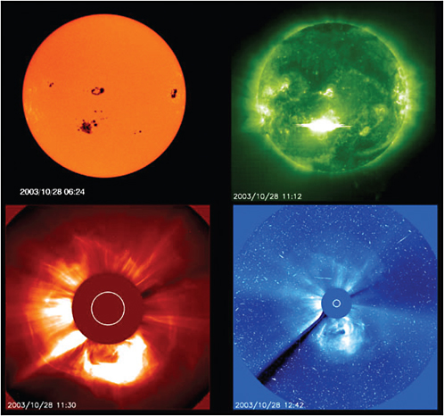
Multispectral Solar Imagery
A broad spectral range of high-resolution solar imagery is necessary to characterize solar activity and features. White-light imagery allows the characterization of sunspots, a long-time measure of solar activity. That is necessary not only to support operational concerns for flare forecasting but also for continuity and enhancement of a data record that dates back several centuries. Hydrogen-alpha imagery provides active region identification and analysis and solar-flare monitoring. Ultraviolet and x-ray imagery allows analysis of the Sun’s chromosphere and corona for active-region development, magnetic-field assessment, and coronal-hole monitoring. Infrared imaging will allow direct measurement of coronal magnetic fields. A vector magnetograph will allow high-resolution determination of solar surface magnetic fields—a critical boundary condition for solar wind modeling and forecasting. Initial missions should be a combination of Earth-orbiting and L1, but over the next 10–20 years the missions should migrate closer to the Sun both to enable higher-resolution imagery of detailed solar processes and to increase the warning time for solar wind disturbances. Multispectral imagers should eventually be placed in solar orbit (both equatorial and polar) at less than 50 solar radii, and plans should include highly elliptical coronal sampler probes. A current gap in solar modeling and forecasting ability is the lack of knowledge about conditions on the Sun’s farside. Future missions should be placed to enable farside observations.
Coronal Mass Ejection Imaging
One of the most dramatic improvements in space-weather forecasting would be the ability to three-dimensionally image and track Earth-directed CMEs. Operational STEREO-type platforms must be continued; three-dimensional CME imaging will be essential to the ability to reliably predict geomagnetic disturbances.
In Situ Solar Wind
Measurements of the solar wind at L1 have greatly improved the ability to anticipate (in the short term) geomagnetic disturbances. L1 measurements are also vital for validating how well models based on solar observations predict conditions on Earth. Solar-wind measurements along the Sun-Earth line should continue and eventually be improved by a capability for making measurements closer to the Sun (increasing forecast lead time) and by making multipoint measurements (to analyze CME structures). Eventual crewed missions to Mars will require a solar-wind monitor at the Mars L1 point.
Ionospheric Mapper
As U.S. dependence on GPS technology continues to grow, so also does the need to specify and forecast conditions in the ionosphere that contribute to GPS errors and outages. Surveying companies, deep-sea drilling operations, land-drilling mining, and military operations all struggle with the economic and societal results of ionospheric effects on GPS. Military and commercial airline communication is affected by ionospheric conditions, especially in the polar regions but also in its dependence on GPS at other locations. To alleviate those impediments to the use of modern technology, better space-weather specification and prediction of conditions in the global ionosphere are needed. Yet, many scientific questions still need to be solved. The space weather research community does not yet fully understand how the ionosphere varies in response to changing solar EUV or how it responds to geomagnetic storms. The community does not yet understand the source of midlatitude ionospheric irregularities or the physics of high- or low-latitude scintillation regions. Those are only a few examples of scientific questions and space-weather issues that can be addressed through improved satellite observations, such as ones that can be made by the Ionospheric Mapper mission.
The Ionospheric Mapper mission is designed to improve the nation’s ability to specify and forecast the ionosphere and its effects on high-frequency (3–30 MHz) through super-high-frequency (3–30 GHz) signal propagation. The primary measurements necessary are related to ionospheric plasma density and to variations in ionospheric signal amplitude or phase induced by small-scale variations in ionospheric properties known as scintillation.
Geostationary UV Imager
A constellation of ionospheric UV imagers could greatly improve the ability to quantify ionospheric scintillation, a primary hazard for communication, radar, and navigation systems. As a phenomenon that is confined primarily to the equatorial and auroral regions, ionospheric scintillation is not ideally suited to measurements from low Earth orbit. Imaging the ionosphere from geostationary orbit has the potential to revolutionize how ionospheric scintillation is characterized and predicted. Eventually, a pole-sitter type of orbit should be used to provide continuous coverage of polar ionospheric conditions. UV imagers at the L1 and L2 points would provide unique local-time-stationary vantage points for ionospheric observing.
Low-Earth-Orbit Ionospheric Sensing
A low-Earth-orbiting component is necessary to obtain in situ ionospheric plasma, electromagnetic field, and neutral atmosphere parameters. Remotely sensed data (e.g., UV imagery) can also be obtained at higher resolution to complement geostationary data. Data from low-Earth polar orbiters offer the only way to characterize the high-latitude ionosphere and scintillation environment. Radio occultation instruments in this orbit would also provide a valuable data set for ionospheric modeling.
High-Density Magnetospheric Network of Microsatellites
With hundreds of communication, navigation, military, and scientific satellites in low Earth orbit through geosynchronous regions, there is a need to specify and forecast the space-weather conditions in which these assets operate. Knowledge of space-weather conditions is vital for the safe and successful operation of spacecraft and to protect the enormous economic investment in the spacecraft and their instruments. Perhaps even more important, it is necessary to protect the societal services provided by the satellites. Satellite operators take actions to protect their systems on the basis of forecasts of magnetospheric conditions, as they did during the Halloween Storm (see Box 10.6), but there are still many outstanding scientific questions that need to be answered to provide more timely and accurate forecasts of space-weather conditions. The formation and depletion of particles in energy ranges from a few electron volts to millions of electron volts must be understood to protect national assets effectively. Energetic particles, such as the so-called MeV electrons, are known to induce charging and damage in spacecraft components, but the physical processes that energize these particles and the processes that cause their loss are not understood. Much work is needed to understand the radiation-belt environment surrounding Earth. There should be a better understanding of magnetospheric current systems (e.g., the ring current and field-aligned currents) that are so critical to geomagnetic-storm evolution and intensity. A high-density magnetospheric network would provide many of the observations needed to improve understanding and to protect resources and services.
The magnetosphere is a region for which data are exceedingly sparse. A few point measurements are available operationally, but there is nowhere near the coverage needed to understand, detect, characterize, and predict the many multiscale processes that occur throughout this tremendous volume of space. Yet, it is the medium within which nearly all satellites operate, and disturbances and changes in that medium can potentially have devastating effects on satellite systems.
Satellite as a Sensor
Every satellite launched into Earth orbit can, and should, include a small on-board sensor to measure the in situ particle environment and include that information in any real-time data streams. Such sensors already exist, are quite small, and use very little power.
Microsatellite-Nanosatellite Networks
Even if every U.S. satellite contained an on-board sensor, coverage would still be insufficient to adequately characterize the magnetosphere. A huge step toward that goal would be a dense network of extremely small, low-cost microsatellites designed to sample the particle and electromagnetic field environment and to transmit results in real time. Such a system, initially deployed throughout the inner magnetosphere, would allow for the possibility of advanced data assimilation and modeling systems for the magnetosphere, analogous to the current observational state for terrestrial weather. As technology improves, nanotechnology could be exploited to produce smaller and smaller sensors that could be deployed in even greater numbers, eventually expanding into the outer magnetosphere and inner heliosphere.
Additional Measurement Capabilities
Radio Occultation Mission
An increase in the accuracy of space-weather services allowing for a 1 percent gain in continuity and availability of GPS would be worth $180 million per year. To achieve such economic gains, it is necessary to improve data-assimilative ionospheric models, which will soon begin to use data from radio occultation missions, such as COSMIC. Of the space-based platforms potentially planned, an operational COSMIC follow-on (such as COSMIC II) holds the most promise to work in synergy with the missions proposed here. Radio occultation measurements (vertical profiles of electron density and line-of-sight total electron content) hold tremendous promise as an observational constraint on ionospheric modeling. Combined with ground-based measurements, they allow for accurate reconstruction of the entire three-dimensional ionosphere. The radio occultation instrument on MetOp could also contribute in this regard, although it is not currently planned to produce ionospheric measurements.
Ground-based Systems
Several ground-based systems are also necessary to provide complementary measurements of the space environment. A global network of ionosonde measurements is necessary to provide bottom-side profiles of the ionosphere—the only means by which such information is available. Ground-based total electron content measurements (using GPS receivers) provide a network of integrated line-of-sight measurements that are best used in combination with both ionosondes and space-based measurements. GPS and SATCOM receiver-based scintillation measurements provide the only direct measures necessary for global and regional scintillation specification and modeling. Incoherent scatter radars, currently used only for research purposes, could be exploited for operational use by providing plasma characteristics, electric fields, and ionospheric convection patterns (critical for accurate modeling). Ground-based magnetometers are necessary, primarily for geomagnetic-disturbance specification and model initialization but also for continuity of long-term geomagnetic observations. Ground-based solar telescopes complement space-based platforms by providing solar observations at lower cost and with greater flexibility, although the resolution and spectral coverage are insufficient to meet all requirements. Radio telescopes in particular are too large to place on space-based platforms and are thus most cost-effectively deployed on Earth’s surface.
SPECIAL ISSUES, REQUIREMENTS, AND COMPLEMENTARY ACTIONS
The panel believes strongly that a successful U.S. program of weather science and applications from space requires much more than new technology on satellites.
International Collaboration
More than 100 environmental satellites are launched each decade. Fewer than 20 percent are solely U.S. missions. Thus, it is important that some of our Earth science for weather continue to be planned in coordination with international partners. New and ever better ways should be used to ensure free and open exchange of data and leveraging of complementary missions. Existing, substantial international collaborations on the TRMM, CloudSat, CALIPSO, GPM, COSMIC, and other missions demonstrate that U.S. Earth science has much to gain from more such activities, including the emerging GEOSS as a new focal point for international activities, joining ICSU, COSPAR, and other proven mechanisms.
Complementary Nonsatellite Observing Systems
Great value is added to weather-related Earth science by suborbital UAVs, ground- and ocean-based observing networks, and in situ observations. In particular, the community recognizes the potential value of UAVs to complement satellite profiles of tropospheric- and chemical-weather variables. UAVs are particularly well suited for conducting tropospheric weather investigations in hazardous environments and when missions require long endurance, such as in investigating and monitoring hurricanes. The ability to provide unique remote and in situ measurements that complement satellite observations can improve forecasts of severe storms in data-sparse regions (e.g., over the oceans). Likewise, the study of chemical and dynamical interrelationships in the troposphere and lower stratosphere requires measurement capabilities over remote regions of the world or at very high altitudes, where the unique capabilities of UAVs are particularly useful. It is only through detailed studies of complex Earth science processes using remote and in situ measurements from ground- and ocean-based and suborbital platforms that the satellite measurements can be properly interpreted. The synergism among different scales of measurements is essential for a complete and robust program.
The Essential Ground Segment: Models, Data Assimilation, and High-Performance Computers
The panel recommends supporting the development of cutting-edge models, data-assimilation tools, and high-performance computers, which are critical for the success of the priority missions. A good portion of U.S. Earth science resources must be placed in a robust ground segment of NOAA, NASA, and partner agencies, with special access provided to the weather science research community. The priority observations and missions recommended by the panel must be designed to optimize their incorporation into modeling systems.
Full exploitation of the missions identified by the Earth science and applications decadal survey requires not only timely and substantive initial analyses but also reanalyses as models and data-assimilation systems advance. The productive use that the weather science community continues to make of reanalyses that are now somewhat obsolete is a testimony to their essential value. NOAA’s relatively new Science Data Stewardship Program for satellite data records should be strengthened for use over the decades. The satellite records are a national asset and must be addressed accordingly. Advances in information technology and new methods for data assimilation will make reanalyses efficient, more accurate, and even more useful in
extracting information from the observing systems if the community plans appropriately for archiving of the required satellite data (NRC, 2005).
Transition of Science Results to Operations and to Users: Agency Collaborations
Without the required flow of new weather science research results to users, the vision of the weather panel will not be realized. Societal and economic applications will be inefficient without the design of end-to-end, research-to-operations, and operations-to-users systems for the coming decades (see NRC, 2000, 2003a,b, 2004). The end-to-end data and product-distribution systems are vital to a successful Earth science program. Academe, the public, the private sector, and user groups must all be parts of the overall program of each new mission. Agencies leading Earth science and applications from space need flexible mechanisms to work together and with external constituencies to fully exploit opportunities in the coming decades.
REFERENCES
Anthes, R.A., C.Rocken, and Y.-H.Kuo. 2000. Applications of COSMIC to meteorology and climate. Terr. Atmos. Ocean. Sci. 11:115–156.
Atlas, R. 2005. Results of recent OSSEs to evaluate the potential impact of lidar winds. Proc. of SPIE 58870K:1–8.
Baker, W., G.D.Emmitt, F.Robertson, RM.Atlas, J.E.Molinari, D.A.Bowdle, J.Paegle, R.M.Hardesty, RT.Menzies, T.N. Krishnamurti, R.A.Brown, M.J.Post, J.R.Anderson, A.C.Lorenc, and J.McElroy. 1995. Lidar measured winds from space: A key component for future weather and climate prediction. Bull. Am. Meteorol. Soc. 76:869–888.
Bauer, P., and A.Mugnai. 2003. Precipitation profile retrievals using temperature sounding microwave observations. J. Geophys. Res. 108(D23):4730.
Bauer, P., P.Amayenc, C.Kummerow, and E.Smith. 2001. Over-ocean rainfall retrieval from multisensor data of the tropical rainfall measuring mission. Part II: Algorithm implementation. J. Atmos. Oceanic Tech. 18:1838–1855.
Bengtsson, L., G.Robinson, R.Anthes, K.Aonashi, A.Dodson, G.Elgered, G.Gendt, R.Gurney, M.Jietai, C.Mitchell, M.Mlaki, A.Rhodin, P.Silvestrin, R.Ware, R.Watson, and W.Wergen. 2003. The use of GPS measurements for water vapor determination. Bull. Am. Meteorol. Soc. 84:1249–1258.
Böckmann, C., I.Mironova, D.Müller, L.Schneidenbach, and R.Nessler. 2005. Microphysical aerosol parameters from multiwave-length lidar. J. Opt. Soc. Am. A 22:518–528.
Cheng, C.-Z., Y.-H.Kuo, R.A.Anthes, and L.Wu. 2006. Satellite constellation monitors global and space weather. EOS 87(17):166.
Edwards, D., P.DeCola, J.Fishman, D.Jacob, P.Bhartia, D.Diner, J.Burrows, and M.Goldberg. 2006. Community input to the NRC decadal survey from the NCAR Workshop on Air Quality Remote Sensing From Space: Defining an Optimum Observing Strategy. Community Workshop on Air Quality Remote Sensing from Space: Defining an Optimum Observing Strategy, February 21–23, 2006, National Center for Atmospheric Research, Boulder, Colo. Available at http://www.acd.ucar.edu/Events/Meetings/Air_Quality_Remote_Sensing/Reports/AQRSinputDS.pdf.
Ferraro, R.R. 1997. Special sensor microwave imager derived global rainfall estimates for climatological applications. J. Geophys. Res. 102(D14):16715–16735.
Gasiewski, A.J., and D.H.Staelin. 1990. Numerical modeling of passive microwave O2 observations over precipitation. Radio Sci. 25(3):217–235.
Grund, C.J., and E.W.Eloranta. 1991. The University of Wisconsin high spectral resolution lidar. Opt Engineering 30:6–12.
Hajj, G., L.C.Lee, X.Pi, L.J.Romans, W.S.Schreiner, P.R.Straus, and C.Wang. 2000. COSMIC GPS ionospheric sensing and space weather. Terr. Atmos. Ocean. Sci. 11:235–272.
IGACO Theme Team. 2004. The Changing Atmosphere, An Integrated Global Atmospheric Chemistry Observation Theme for the IGOS Partnership. ESA SP-1282, GAW Report No. 159 (WMO TD No. 1235). European Space Agency, Noordwijk, The Netherlands.
Kummerow, C.D., Y.Hong, W.S.Olson, S.Yang, R.F.Adler, J.McCollum, R.Ferraro, G.Petty, D.B.Shin, and T.T.Wilheit. 2001. The evolution of the Goddard Profiling Algorithm (GPROF) for rainfall estimation from passive microwave sensors. J. Appl. Meteorol. 40:1801–1817.
Kursinski, E.R., G.A.Hajj, S.S.Leroy, and B.Herman. 2000. The GPS radio occultation technique. Terr. Atmos. Ocean. Sci. 11:53–114.
Le Marshall, J., J.Jung, J.Derber, R.Treadon, S.J.Lord, M.Goldberg, W.Wolf, H.C.Liu, J.Joiner, J.Woollen, R.Todling, and R. Gelaro. 2005. Impact of atmospheric infrared sounder observations on weather forecasts. EOS 86(11):109, 115–116.
Lee, L.-C., C.Rocken, and R.Kursinski. 2000. Applications of Constellation Observing System for Meteorology, Ionosphere and Climate. Springer, New York.
Müller, J.-P., A.Mandanayake, C.Moroney, R.Davies, D.J.Diner, and S.Paradise. 2002. MISR stereoscopic image matchers: Techniques and results. Trans. Geosci. Remote Sens. 40:1547–1559.
NRC. 2000. From Research to Operations in Weather Satellites and Numerical Prediction: Crossing the Valley of Death. National Academy Press, Washington, D.C.
NRC. 2003a. Fair Weather: Effective Partnerships in Weather and Climate Services. The National Academies Press, Washington, D.C.
NRC. 2003b. Satellite Observations of the Earth’s Environment: Accelerating the Transition of Research to Operations. The National Academies Press, Washington, D.C.
NRC. 2003c. The Sun to the Earth—and Beyond: A Decadal Research Strategy in Solar and Space Physics. The National Academies Press, Washington, D.C.
NRC. 2004. Utilization of Operational Environmental Satellite Data: Ensuring Readiness for 2010 and Beyond. The National Academies Press, Washington, D.C.
NRC. 2005. Earth Sciences and Applications from Space: Urgent Needs and Opportunities to Serve the Nation. The National Academies Press, Washington, D.C.
Riishojgaard, L.P. 2005. High-latitude winds from Molniya orbit: A mission concept for NASA’s Earth System Science Pathfinder program. Pp. 120–124 in 2005 International Workshop on the Analysis of Multi-Temporal Remote Sensing Images, Third International Workshop on the Analysis of Multi-temporal Remote Sensing Images, Biloxi, Miss. IEEE, Washington, D.C.
Sroga, J.T., E.W.Eloranta, and T.Barber. 1980. Lidar measurement of wind velocity profiles in the boundary layer. J. Appl. Meteorol. 19:598–605.
Stoffelen, A., J.Pailleux, E.Källén, J.M.Vaughan, L.Isaksen, P.Flamant, W.Wergen, E.Andersson, H.Schyberg, A.Culoma, R. Meynart, M.Endemann, and P.Ingmann. 2005. The Atmospheric Dynamics Mission for global wind field measurement. Bull. Am. Meteorol. Soc. 86:73–87.
Velden, C., J.Daniels, D.Stettner, D.Santek, J.Key, J.Dunion, K.Holmlund, G.Dengel, W.Bresky, and P.Menzel. 2005. Recent innovations in deriving tropospheric winds from meteorological satellites. Bull. Amer. Meteor. Soc. 86:205–223.


