
3
From Satellite Observations to Earth Information
The mission plan presented in Chapter 2 aims to establish a program that is effective in its use of resources, resilient in the face of the evolving constraints within which any program must operate, and able to embrace new opportunities as they arise. However, the missions are but one part of a larger program that is required to translate raw observations of Earth into useful information. In this chapter, the committee highlights key additional elements of the overall program in Earth science and applications that must be supported to achieve an effective Earth information system, including sustained observations from space for research and monitoring; surface-based (land and ocean) and airborne observations to complement and augment space-based observations; research, data assimilation and analysis, and modeling to enable effective use of the observations in analyses and forecasts; and planning, education and training, and other activities to strengthen and sustain the Earth knowledge and information system. Those elements are each complex and deserve attention by the federal agencies, academe, and the private sector. Although a detailed analysis and set of recommendations associated with each would be well beyond the scope of this report, the elements are summarized here to note their importance as parts of a complete program in Earth science and applications.
SUSTAINED OBSERVATIONS FOR OPERATIONS, RESEARCH, AND MONITORING
Scientific breakthroughs are often the result of new exploratory observations, and new technology missions stimulate and advance fundamental knowledge about the planet. Analysis of new observations can both test hypotheses developed to elucidate fundamental mechanisms and lead to the development of models that explain or predict important Earth processes. The data from new technology missions sometimes hint at changes in Earth that are critical to people’s well-being, such as a decline in the ice cover in the Arctic Ocean, development of holes in the protective ozone layer, or a rise in sea level. To determine the long-term implications of such changes or to uncover slowly evolving dynamics, the measurements must be continued, usually with follow-on missions. For example, the long-term global record of vegetation’s photosynthetic activity—a record based on measurements made by multiple sensors—is proving to be critical for identifying changes in the length of growing seasons and productivity in response
to climate change. Such sustained observations allow scientists to document changes, to determine the processes responsible for changes, and to develop predictions. They also are often needed to allow resource managers to assess the ongoing effects of changes on society.
Data from a new technology mission sometimes prove critical for an operational system. Wind speed and direction measurements from NASA’s QuikSCAT mission and precipitation measurements from NASA’s Tropical Rainfall Measurement Mission (TRMM), for example, are used in weather forecasting. The need for such measurements to become part of an operational system and to be sustained for many years is a recognized and well-studied challenge, but the record of moving new technology into operational systems is, at best, mixed.1
Another aspect of the connectivity between sustained research observations and operational systems is that the observations and products from those systems, such as the observations used in weather forecasts, are also useful for many research purposes. Likewise, sustained observations, although focused on research questions, clearly include an aspect of monitoring and may be used operationally. Exploratory, sustained, and operational measurements often share the need for new technology, careful calibration, and long-term stability, but there are also important differences among them.
The ability to reach across the overlapping categories of exploratory, sustained, and operational Earth observations has not proved very successful, and the recent experience with the National Polar-orbiting Environmental Satellite System (NPOESS) is particularly problematic and revealing with respect to sustained measurements (Box 3.1).
Climate data records (CDRs) are time series of measurements of sufficient length and accuracy to document climate variability and change.2 Such records are invaluable because an examination of the causes of changes in Earth processes often requires long, stable, accurate records of several variables. For example, to investigate links between hurricane intensity and global warming (Emanuel, 2005; Webster et al., 2005) by determining whether there is a connection between the power of hurricanes and a warming ocean, it is necessary to have long and accurate records of both hurricane wind speeds and ocean temperatures; Box 3.2 provides additional examples.
In addition to an observation system that routinely makes critical measurements, obtaining CDRs requires a substantial commitment by a team of experts to support data reprocessing, the resolution of differences in sensor characteristics, and evaluation of data for research and applications. For example, measurements of sea-surface temperature were improved through several joint agency efforts (such as the NOAA-NASA Pathfinder program and the Global Ocean Data Assimilation Experiment (GODAE) of the National Oceanographic Partnership Program) and, more recently, by combining infrared measurements with those from a microwave radiometer that can measure through the ubiquitous cloud cover (the GODAE High Resolution Sea Surface Temperature Pilot Project, GHRSST-PP3).
Calibration and validation in the context of CDRs can be considered a process that encompasses the entire system, from sensor to data product (NRC, 2004b). The objective is to develop a quantitative understanding and characterization of the measurement system and its biases in time and space; this involves a wide array of strategies that depend on the type of sensor and data product. For example, for ocean color,
|
1 |
Transition failures have been exhaustively described in previous reports (NRC, 2000a, 2003b), and this committee supports their analyses and recommendations. |
|
2 |
Characterization of many Earth processes requires sustained and carefully calibrated data, including a history of continuous and consistent measurements, and so the challenge extends beyond the issue of climate. The distinction between CDRs and the NPOESS EDRs is discussed in NRC (2004a). |
|
3 |
Proceedings of the Fourth GODAE High Resolution SST Pilot Project Workshop, Pasadena, California, September 22–26, 2003. GHRSST-PP Report No. GHRSST/18. GODAE Report No. 10. Available at http://dup.esrin.esa.it/files/project/131–176–149–30_20068812258.pdf. |
|
BOX 3.1 NPOESS, EOS, AND THE SEARCH FOR SUSTAINED ENVIRONMENTAL MEASUREMENTS The NPOESS program was, at the outset, driven by a single imperative—convergence of weather measurements, which would eliminate duplication in observations in the early afternoon but maintain the same temporal robustness that characterized the combination of the Polar Operational Environmental Satellite and the Defense Meteorological Satellite Program. The cost savings from eliminating duplication could then be reallocated to improve weather observations and models. By the mid-1990s, it was clear that NASA would not sustain a long-term, broad observation and informationprocessing program like the Earth Observing System (EOS); therefore, the community developed a new strategy for obtaining climate measurements from NPOESS. That led to a second NPOESS program imperative—operationalizing a climate observing system, which would enable sustained, long-term measurements for climate studies and other environmental issues. However, that was done after consideration of optical designs, orbits, and data systems needed for weather forecasts; additional requirements for climate were then added, and they invoked different objectives and thus requirements for optical designs, orbits, and other mission and instrument characteristics. Attempting to satisfy the two imperatives simultaneously constituted a difficult challenge, both technically and programmatically. Part of the challenge arose from trying to balance the inherent mismatch of data requirements. Weather forecasts demand frequent observations and rapid data dissemination, but climate studies and research demand accurate and consistent long-term records. The added requirements of instrument stability and accuracy, driven by the more stringent climate requirements, placed additional challenges on the instruments. Moreover, the expanded mission’s requirements to address climate and other environmental issues established demands for additional observations, such as ocean altimetry, which were themselves not weather-related. That expanded the scope of the mission, increased its complexity, and added to the pressure for larger platforms. Finally, although the mission of one of the operational partners (the Department of Commerce’s NOAA) included climate and other broad environmental issues, the mission of the other (the Department of Defense’s Air Force) did not. That led to conflicting priorities between the two agencies, which by law were required to share program costs on a 50–50 basis. |
for which the dominant satellite-sensed signal is from the atmosphere, monthly viewing of the Moon is essential to quantify changes in sensor response.
In its interim report (NRC, 2005), this committee recommended that NOAA embrace its new mandate to understand climate variability and change by asserting national leadership in applying new approaches to generate and manage satellite CDRs, developing new community relationships, and ensuring long-term accuracy of satellite data records.4 The committee also noted that NOAA had stated its intention to create CDRs from data gathered by NPOESS. However, as detailed elsewhere in this report (see, for example, Tables 2.4 and 2.5 and discussions in Chapter 9), the NPOESS program has been substantially descoped to a focus only on “core” missions related to weather. Despite obvious consequent limitations on the utility of NPOESS for climate studies, some of the remaining instruments are potentially capable of producing CDRs if the requisite programs and facilities are in place. Therefore, the committee reiterates its previous recommendation (NRC, 2005, p. 8):
|
4 |
See NRC (2004a); see also testimony before the House Subcommittee on Environment, Technology, and Standards, House Committee on Science, by Mark R. Abbott, Dean, College of Oceanic and Atmospheric Sciences, Oregon State University, on July 24, 2002, available at http://gop.science.house.gov/hearings/ets02/jul24/abbott.htm. |
|
BOX 3.2 SUSTAINED RESEARCH OBSERVATIONS AND THE CHALLENGE OF CLIMATE RECORDS Sustained measurements are needed to distinguish short-term variability in the Earth system from long-term trends. Sea level, for example, is monitored with a radar altimeter that measures the height of the ocean relative to a fixed reference level. Sea level must be measured with accuracy sufficient to distinguish 50-mm seasonal variations from the 3-mm climate signal (Figure 3.2.1, top). The exceptionally long data record of the TOPEX/Poseidon (T/P) mission gave an estimate of global sea-level rise of about 3 mm/year. If T/P had failed late in 1997, the increase in sea level in 1997 would have appeared to represent an acceleration of sea-level rise rather than an anomalous peak in a longer-term trend. A follow-on mission to T/P, Jason-1, a cooperative effort of the U.S. and French space and operational agencies, was launched before T/P failed. An overlap period of 4 years between the two missions allowed the science and engineering teams to detect and correct for a slow degradation of the T/P tracking system to give a continuous record of sea-level rise. Such overlap is particularly important in climate observations. The design of systems for climate observing and monitoring from space must ensure the establishment of global, long-term climate records that are of high accuracy, tested for systematic errors on-orbit, and tied to irrefutable standards, such as those maintained in the United States by the National Institute of Standards and Technology. For societal objectives that require long-term climate records, the accuracy of core benchmark observations must be verified against absolute standards on-orbit by fundamentally independent methods so that the accuracy of the record archived today can be verified by future generations. Societal objectives also require a long-term record that is not susceptible to compromise by interruptions. Climate observations are different from weather observations; for example,the continuing debate over the reliability of surface-temperature records and the community’s inability to establish the upper-air temperature record over the last several decades stem from attempts to create climate records from what are essentially weather-focused observations. The issue of sea-level rise also illustrates the importance of sustained in situ measurements. Observations of ocean temperatures from a network of drifting buoys, Argo, provided the foundation for estimating the contribution of a warming ocean (about 1.7 mm/year) to sea-level rise. The residual of 1.3 mm/year (Figure 3.2.1, bottom) is the result of other processes that presumably melt ice sheets—a contribution that may accelerate sea-level rise in the future. The residual sea-level rise can then be compared with estimates of changes in ice volume to verify that presumption. Trends in all the measurements are needed to calibrate climate models that predict changes in sea level and in other climate variables. This example illustrates the importance of avoiding gaps in the data record, of coordinating satellites with other measurement programs, and of supporting science and engineering teams in maintaining and interpreting the observations. |
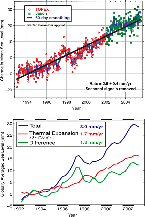 FIGURE 3.2.1 (Top) Estimates of global sea level from the TOPEX/Poseidon (red) and Jason (green) missions. The total rate of rise is about 3 mm/year. SOURCE: Courtesy of University of Colorado (http://sealevel.colorado.edu) and Leuliette et al., 2004. (Bottom) An estimate of the contribution of expansion of the warming ocean (1.7 mm/year) to sea level from Argo drifting buoys. The difference of 1.3 mm/year is from the melting of the polar ice sheets. SOURCE: Courtesy J.Willis, NASA/JPL, from Willis et al., 2004. Copyright 2004 American Geophysical Union. Reproduced/modified by permission of American Geophysical Union. |
Recommendation: NOAA, working with the Climate Change Science Program and the international Group on Earth Observations, should create a climate data and information system to meet the challenge of ensuring the production, distribution, and stewardship of high-accuracy climate records from NPOESS and other relevant observational platforms.
Experience with the Landsat series of satellites provides another prime example of the difficulty in moving an instrument technology along the path from exploratory to sustaining, and eventually to operational missions. Continuing Landsat-type land-surface measurements does not fall within the charter of NOAA, requires greater budget capacity than is available within the U.S. Geological Survey (USGS), and is incompatible with NASA’s mission of developing new science and technology. As a consequence, the Landsat 7 follow-on will suffer a data gap that will be highly detrimental to users of critical long-term sustained measurements. Furthermore, over the last 4 years, the program was moved from NASA to NOAA (operational land imager on NPOESS) and back to NASA, where it is now moving slowly forward.
The committee is concerned that the nation’s institutions involved in civil Earth science and applications from space (including NASA, NOAA, and USGS) are not adequately prepared to meet society’s rapidly evolving Earth information needs. Those institutions have responsibilities that are in many cases mismatched with their authorities and resources: institutional mandates are inconsistent with agency charters, budgets are not well matched to emerging needs, and shared responsibilities are supported inconsistently by mechanisms for cooperation. These are issues whose solutions will require action at high levels of the federal government. Thus, the committee makes the following recommendation:
Recommendation: The Office of Science and Technology Policy, in collaboration with the relevant agencies and in consultation with the scientific community, should develop and implement a plan for achieving and sustaining global Earth observations. This plan should recognize the complexity of differing agency roles, responsibilities, and capabilities as well as the lessons from implementation of the Landsat, EOS, and NPOESS programs.
The committee notes that similar advice addressed explicitly to NASA’s Science Mission Directorate (SMD) was offered in the National Research Council review of the SMD draft science plan (NRC, 2006d, p. iv):
-
NASA/SMD should develop a science strategy for obtaining long-term, continuous, stable observations of the Earth system that are distinct from observations to meet requirements by NOAA in support of numerical weather prediction.
-
NASA/SMD should present an explicit strategy, based on objective science criteria for Earth science observations, for balancing the complementary objectives of (i) new sensors for technological innovation, (ii) new observations for emerging science needs, and (iii) long-term sustainable science-Grade Environmental Observations.
OBSERVATIONS TO COMPLEMENT THOSE MADE FROM SPACE
Space-based observations provide a global view of many Earth system processes, but they have limitations, including spatial and temporal resolution and the inability to observe some parts of Earth. Hence, they do not provide a picture of the Earth system that is sufficient for understanding key physical, chemical, and biological processes. In situ observations on the surface (land and ocean) and in the atmosphere complement satellite observations by providing calibration and validation and by obtaining critical data
in places and with levels of accuracy, precision, and resolution that are not obtainable from space. In addition, satellites do not directly observe many of the changes in human societies that are affected by or affect the environment. An effective Earth information system therefore requires several additional types of observations to complement the observations from space.
Surface-based and Suborbital Airborne Observations
Before satellites were available, the global observing system that supported weather prediction and research5 consisted primarily of land-based observing systems, reports from ships on ocean conditions, balloon-borne systems (such as radiosondes), and aircraft reports. Those systems remain important and constitute a fundamental part of the integrated global observing system (see http://www.wmo.ch/web/www/OSY/GOS.html; Uppala et al., 2005; and Appendix C). Currently, however, the number of upper-air radiosonde observations is declining in many parts of the world, although the decline is compensated for in part by increasing satellite observations (Uppala et al., 2005).
The surface-based network of meteorological observing stations in the United States, although adequate for weather prediction, is inadequate for climate monitoring and research because of siting, accuracy, and precision issues. To remedy the situation, NOAA is developing the U.S. Climate Reference Network (USCRN; see www.ncdc.noaa.gov/oa/climate/uscrn/), a network of about 100 climate stations whose primary goal is to provide long-term homogeneous observations of temperature and precipitation that can be coupled to long-term historical observations for the detection and attribution of present and future climate change. Data from the USCRN will be used in operational climate-monitoring activities and for placing current climate anomalies into a historical perspective. The USCRN will be a reference network that meets the requirements of the Global Climate Observing System.
Routine aircraft observations play an important role in operational weather forecasting (Uppala et al., 2005). They have also been important in the formulation of public-policy legislation and in the systematic testing and improvement of forecast models across broad categories in the Earth sciences. For example, they have contributed to:
-
Establishment of the Montreal Protocol limiting the international release of chlorofluorocarbons;
-
Limitations on nitrate, sulfate, carbon, and heavy-metal emission from industrial sources;
-
Tracking and forecasting of hurricane trajectories and other severe storm systems;
-
Monitoring of solid-Earth hazards, such as volcanic eruptions and landslides;
-
Establishment of the mechanistic coupling between dynamics, radiation, and chemistry in Earth’s climate system; and
-
Assessment of damage from natural disasters and the establishment of tactics for providing relief to survivors.
Yet, strikingly, at a time when the scientific and societal need for a robust national capability in aircraft research and surveillance has never been greater, NASA’s competence and resources in airborne research facilities have eroded to the point that they are now in serious jeopardy. The decline is seen in increasing limitations on aircraft available for deployment, decreased support for instrument development, lack of funds to stage missions, and a loss of technical infrastructure to execute needed objectives.
To compound the effects of a substantially weakened airborne program, virtually every satellite instrument developed for observations of Earth from space was conceived and first tested on an aircraft platform. In addition, graduate programs in experimental science and engineering are built on a backbone of airborne research that is now collapsing. Restoring the nation’s airborne research program is a prerequisite for linking the Earth sciences to emerging societal objectives and for the restoration of U.S. leadership in higher education internationally.
The airborne programs of NASA and NOAA are in transition from conventional aircraft to unmanned aerial vehicles (UAVs). UAVs have the potential to revolutionize suborbital remote and in situ sensing with their increased range and loiter time and their ability to penetrate hazardous environments. However, issues with avionics software, flights over populated regions, high cost, and reliability have thus far limited UAVs to controlled demonstration missions. In the transition to future wide deployment of UAVs, conventional aircraft will continue to be the mainstay of the suborbital aircraft program—they are more reliable and more cost-effective to use. The committee notes that the current neglect of conventional aircraft programs in favor of UAV development has hindered scientific research; its recommendations below point toward a strengthened and balanced program of conventional aircraft and UAV.
Recommendation: Critical surface-based (land and ocean) and upper-air atmospheric sounding networks should be sustained and enhanced as necessary to satisfy climate and other Earth science needs in addition to weather forecasting and prediction.
Recommendation: To facilitate the synthesis of scientific data and discovery into timely information for end users, NASA should support Earth science research via suborbital platforms: airborne programs, which have suffered substantial diminution, should be restored, and unmanned aerial vehicle technology should be increasingly factored into the nation’s strategic plan for Earth science.
Observations of Human Impacts
Human influences on Earth are apparent on all spatial and temporal scales. Thus, an effective Earth information system requires an enhanced focus on observing and understanding the effects of humans, the influence and evolution of the built environment, and the study of demographic and economic issues. For instance, space-derived information on urban areas can provide a platform for fruitful interdisciplinary collaboration among Earth scientists, social scientists (such as urban planners, demographers, and economic geographers), and other users in the applications community. Data on the geographic “footprint” of urban settlements, identification of urban land-use classes, and changes in these characteristics over time are required to facilitate the study of urban population dynamics and composition and thereby to improve the representation of human-modified landscapes in physical and ecological process models. Because of the rapid growth in urban areas—particularly in the developing world, where there are few alternative sources of information on urban extent and land cover—observations are needed to understand the increasing effects of anthropogenic forces on regional weather and climate, air and water quality, and ecosystems and to apply this understanding to protect society and manage natural resources.
Recommendation: Earth system observations should be accompanied by a complementary system of observations of human activities and their effects on Earth.
RESEARCH AND ANALYSIS, DATA ASSIMILATION, AND MODELING TO TURN OBSERVATIONS INTO KNOWLEDGE AND INFORMATION
Many steps along many pathways are necessary to turn observations into quantitative information for use by scientific researchers and societal decision makers. A central theme of this report is that space-based observation of Earth must address important societal needs—there must be a closer linkage to providing real benefits. To meet important needs, there must be a greater ability to extract information coherently from multiple observations and sensors and to address the already-well-known challenges of data management. Observations without analysis, interpretation, and application are sterile, and it is thus crucial to ensure the vitality of research, analysis, and modeling programs.
Consideration of Societal Benefits and Applications
Chapter 5 in Part 111 discusses a number of important aspects of the process of realizing societal benefits from Earth observations through scientific research and the development of applications. They include establishing mechanisms for including priorities of the applications community in space-based missions, considering studies of the value and benefits of Earth observations published in the social-sciences literature, creating closer institutional relationships between the science and applications (user) communities, ensuring ready access to observations and products derived from observations by the broad user community, and educating and training new users of Earth data and facilitating the creation of a scientifically informed and literate citizenry. Meeting those objectives will require a greater involvement of social scientists (such as development-policy analysts, communication researchers, anthropologists, and environmental economists) throughout the entire mission life cycle to make certain that societal needs are appropriately considered during the design process and to ensure that societal benefits are derived from the implemented observations.
Recommendation: Socioeconomic factors should be considered in the planning and implementation of Earth observation missions and in developing an Earth knowledge and information system.
Deriving Data from Multiple Observations and Sensors
Observations must resolve appropriate temporal and spatial scales, which depend on the nature of the processes examined and the scientific questions posed. Simply specifying a measurement is not sufficient; thorough analyses are required to estimate measurement errors (such as noise in a sensor) and sampling errors (which are related to the sampling characteristics of the sensor and to geophysical variability). Such considerations imply that many Earth science questions and applications require a suite of platforms in different orbits. Merged data products from different sensors (in different orbits or with different spectral characteristics) often overcome weaknesses that are present in a single-sensor approach. For example, infrared sensors can provide high-spatial-resolution measurements of sea-surface temperature, but not in the presence of clouds, whereas microwave sensors can “see” through clouds, but with much lower spatial resolution. Combining the output of those systems in a rigorous statistical manner yields a much higher-quality field of global sea-surface temperature.6 Appendix C provides additional examples of how observations of the same variable (such as temperature) with different technologies (such as infrared, microwave,
and GPS) can be combined through four-dimensional variational data assimilation to produce analyses of a variable that are more accurate than the original observations alone.
An emerging source of data is the commercial sector. In the past, a program of Earth observations was associated almost exclusively with government-managed or government-sponsored projects. Today, commercial sources of Earth information are rapidly increasing in availability and scope. Commercial satellite systems are now reliable sources of high-resolution Earth imagery, and commercial remote-sensing companies have greatly expanded their offerings. An important example is evident in the emerging Internet geospatial browsers and Web portals, best exemplified by Google Earth and Microsoft Virtual Earth. The new technologies increase dramatically the ability to communicate Earth information to consumers, to share data and information among diverse groups, and to receive feedback from the end users of Earth information. Much of this capability is available for free. A long-term plan for Earth observations and information needs to account for the new sources; they promise to reduce the cost of Earth observation and to introduce new and different ways of looking at Earth.
In reviewing the progress of commercial data providers in obtaining Earth observations and their potential applicability to the decadal plan, the committee sought input on providers of data from both space-based and airborne sources. The detailed and thoughtful responses of two groups7 indicated a clear expectation for rapidly evolving capabilities over the next decade, including imagery with increasingly fine spatial resolution and substantial improvements in geolocation accuracy. Prices are expected to drop as sources proliferate, and enhanced spectral capability is anticipated, with the possibility that hyperspectral data could become available from commercial sources. Constellations of imaging satellites, designed to reduce intervals between observations, are envisioned. Radar imagery would become widely available, with highly accurate global digital elevation models constituting one product. Much of the demand for such imagery will come from rapidly emerging consumer geospatial Internet applications, but the scientific community should also be able to take advantage of these data sets to complement those obtained with other observing systems. Nevertheless, most of what is important scientifically will not be provided in the foreseeable future by commercial providers. Commercial sources should be viewed as an important and high-leverage adjunct to government-sponsored systems, not as a general replacement.
New satellite data sources may reduce the need for conventional observations or observations from earlier satellite systems. In a cost-constrained environment, a continued increase in observation systems cannot be supported and in fact may not be necessary as more effective systems replace older, less effective ones. Thus, a systematic and continuous evaluation and assessment of the appropriate mix of global observations is necessary.
Recommendation: For the global observing system to evolve in a cost-effective way so that it can meet broad scientific and societal objectives and extract maximal useful information from multiple observations and sensors, teams of experts should be formed to focus on providing comprehensive data sets that combine measurements from multiple sensors. The teams should consider assimilation of data from all sources, including commercial providers and international partners.
Data and Information Management
Earth observation is a data-rich endeavor involving processing, archiving, and distributing vast amounts of data. To achieve the benefits of the Earth observations recommended in this report, support must be provided to the full range of data processing, analysis, archiving, and distribution for all space missions
(see Chapter 5). The data must be made easily and affordably available to users to support research and applications. The rapidly emerging geospatial Internet promises new ways both to store and to distribute Earth-related information and may provide opportunities to enhance the archiving and distribution of scientific information.8
The challenges of data archiving and access have been discussed in many previous reports of the National Research Council. The report Government Data Centers: Meeting Increasing Demands (NRC, 2003a) focused on technological approaches that could enhance the ability of environmental data centers to deal with increasing data volume and user demands and improve the ability of users to find and use information held in data centers. The report Utilization of Operational Environmental Satellite Data: Ensuring Readiness for 2010 and Beyond (NRC, 2004b) focused on the end-to-end use of environmental satellite data by characterizing the links from the sources of raw data to the end requirements of various user groups.
Recommendation: As new Earth observation missions are developed, early attention should be given to developing the requisite data processing and distribution system, and data archive. Distribution of data should be free or at low cost to users, and provided in an easily accessible manner.
Research and Analysis
A careful review of important scientific advances in the Earth sciences in recent years, particularly developments linked most directly to societal decisions (the Montreal Protocol; hurricane forecasting; toxicity studies of exposure to nitrates, sulfates, and heavy metals; earthquake forecasting; and mechanistic coupling between dynamics, radiation, and chemistry in the climate system), reveals the central importance of NASA’s research and analysis (R&A) programs to the national effort. In fact, U.S. scientific leadership, vitality, and technical agility rest directly on the nation’s R&A; moreover, these programs are essential to the education of graduate students in the nation’s universities who will become the next generation of Earth scientists (see, e.g., NRC, 1995). R&A studies enable conversion of raw instrument data into useful fields of geophysical variables and are a critical component of the research required to convert data analyses to trends, to understand processes, and to improve models. Without adequate R&A, the large, expensive, and complex tasks of acquiring, processing, and archiving geophysical data would be essentially wasted. Strong R&A programs in NASA, NSF, NOAA, USGS, and other agencies are crucial to realize the benefits from Earth observations. In its interim report, the committee expressed concern regarding the consequences of reductions in the level of support NASA was providing to its Earth observation R&A programs (NRC, 2005, p. 7). This concern has only increased given that the mission plan summarized in Chapter 2 assumes a strengthened R&A program—one that is commensurate with current needs and those anticipated as the mission plan is executed. Thus, the committee makes the following recommendation:
Recommendation: NASA should increase support for its research and analysis (R&A) program to a level commensurate with its ongoing and planned missions. Further, in light of the need for a healthy R&A program that is not mission-specific, as well as the need for mission-specific R&A, NASA’s space-based missions should have adequate R&A lines within each mission budget as well as mission-specific operations and data analysis. These R&A lines should be protected within the missions and not used simply as mission reserves to cover cost growth on the hardware side.
|
8 |
See, for example, presentations at the NOAA Data and Information Users’ Workshop, May 11–13, 2005, available at http://www.ncdc.noaa.gov/oa/usrswkshp/index.html#report. |
|
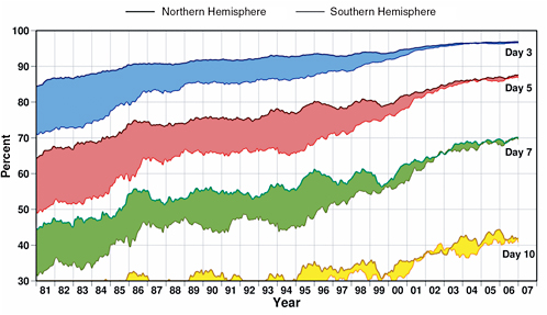
BOX 3.3 THE WEATHER PREDICTION PARADIGM AND THE USE OF EARTH OBSERVATIONS Numerical weather prediction (NWP) models have for many years been the primary basis of weather forecasts for periods beyond a day. The models depend critically on observations for their initial conditions. The earliest models in the 1960s and 1970s relied almost entirely on in situ observations of four traditional atmospheric variables—temperature, pressure, winds, and water vapor—obtained primarily by weather balloons, aircraft, ships, and surface-observing stations over land. The observations were generally made and used in the models at 12-h intervals (00 UTC and 12 UTC). The relatively few observations made at other times were generally not used in the models. The earliest Earth-observing satellites were developed mainly to improve weather forecasts. Throughout the 1960s and 1970s, although the visible and infrared imagery from satellites helped forecasters for short-term forecasts, quantitative satellite data like infrared and microwave radiances had little favorable effect on NWP models and in fact actually degraded the forecasts in many cases. That was because modelers were trying to convert the satellite observations (such as radiances) to conventional observations (such as temperature and water vapor). By the 1990s, however, researchers had developed powerful new methods to use radiances and other nontraditional observations, such as radar backscatter measurements, in models through increasingly sophisticated data assimilation techniques based on rigorous mathematical and physical principles (see Appendix C). Those methods also allowed models to use effectively the many satellite observations that were made throughout the day rather than only those at two fixed times. Over the decades of the 1980s and 1990s and continuing today,the increasing number and types of global satellite observations, the improving methods of assimilating the many diverse data, and improved models have been responsible for a remarkable increase in model forecast accuracy, which in turn has led to steadily improving weather forecasts. Figure 3.3.1 shows the monthly moving average of the correlations between forecast and observed anomalies of the 500-hPa-height fields (essentially the pressure fields at about 5.5 km, or 18,000 ft, in the atmosphere) in 3-, 5-, 7-, and 10-day forecasts. Forecasting those anomalies accurately is essential in forecasting weather; the higher the correlation, the better the forecast. Numerical forecasts with correlations of 60 percent or higher are generally considered useful. The top part of each band refers to the accuracy of the Northern Hemisphere (NH) forecasts;the bottom part, the Southern Hemisphere (SH) forecasts. Figure 3.3.1 shows a number of interesting and important features. First, in 1981, the NH forecasts were significantly better than those in the SH, because there were (and still are) many more traditional observations in the NH. With time,the forecasts have steadily improved, and the 5-day forecast today in the NH is as accurate as the 3-day forecast was in 1981. That improvement has occurred in spite of the fact that the number of conventional upper-air observations has decreased (Uppala et al., 2005). Figure 3.3.1 also shows that the difference in accuracy between the forecasts in the two hemispheres has become much smaller; in fact, there is little difference today. That is also because of satellite observations, which cover the two hemispheres equally. The paradigm of assimilating observations of different geophysical variables made from many instruments and platforms into mathematically and physically based numerical models has been responsible for the |
Modeling
The complexity of the Earth system means that few problems of significance can be solved analytically or from observations alone. The tremendous advances in weather prediction—largely the result of steadily improving models, satellite data, and advanced data assimilation techniques (Box 3.3; see also Uppala et al., 2005, and Appendix C)—constitute a tangible example; such prediction is now based almost entirely on computational models. In fact, Uppala et al. (2005) concluded that improving models and data assimi-
lation, including higher model resolution made possible by increasing computer power, have been the main reasons for improvement in global weather predictions since 1980. Computational modeling and model-based analyses will play a central role in the quest for increasingly detailed data and information to improve knowledge of the Earth system and the ability to make practical predictions. Complete models of the Earth system must be developed with advanced data-assimilation techniques that can incorporate all observations into a model to produce consistent four-dimensional data sets for research and operations.
Like investments in R&A, support for modeling, data assimilation, and advanced computation must be commensurate with the proposed observation systems.
Recommendation: NASA, NOAA, and USGS should increase their support for Earth system modeling, including provision of high-performance computing facilities and support for scientists working in the areas of modeling and data assimilation.
PLANNING AND EDUCATION TO SUSTAIN AN EARTH KNOWLEDGE AND INFORMATION SYSTEM
A successful Earth information system needs to be planned and implemented according to a long-term strategy that encompasses the life cycle from research to operations to applications. The strategy must include nurturing an effective workforce, informing the public, sharing in the development of a robust professional community, and ensuring effective and long-term access to data. An active planning process should focus on effectively implementing the committee’s recommendations for the next decade and sustaining and building the Earth knowledge and information system beyond the next decade. Although any successful program depends on people in leadership positions, the process must be resilient in the face of changes in leadership that are inevitable over long periods. This section highlights the need for continual planning of the satellite observing program in the presence of funding and technology uncertainties, for moving selected measurements from research to operations and applications, and for training the next generation of Earth information specialists.
Planning for Uncertainty: Reviewing and Revising Plans
The missions recommended in Chapter 2, together with other national and international missions, can provide the space-based observational foundation for the coming decade of Earth information needs. However, the missions were developed in the context of programmatic constraints and available resources that are expected to evolve. Budgets occasionally increase, bringing opportunities to enhance a program; they also decline, forcing cuts and requiring new priorities. Technological advances are difficult to predict, and some missions that depend on a new technology may not be ready to fly on the originally planned schedule. All programs thus should be reviewed regularly by an external, independent, community-based advisory body to identify potential problems and new opportunities.
Given the challenges of any high-technology program and the experience of cost growth in executing missions, the committee formulated a set of programmatic decision strategies and rules (Box 3.4) that should be considered, in consultation with such an advisory body, when program restructuring is necessary or desirable. More broadly, the strategies and rules are intended to aid overall programmatic management.
The programmatic decision strategies summarized in Box 3.4 are derived from principles discussed in a number of previous NRC studies. Regarding the maintenance of overall program integrity, an effective and robust Earth observation program must be balanced in a number of important ways (NRC, 2006b):
-
Balancing scientific disciplines. Earth system science depends on a wide array of scientific disciplines and progress in all areas of importance. The very nature of scientific enquiry and discovery means that there will be surprises, which often come from unexpected and unplanned places. What seems to be most important in one year may be superseded by another great challenge or opportunity in the next.9 Furthermore, multidisciplinary and interdisciplinary research and cooperation can yield transformative
|
BOX 3.4 PROGRAMMATIC DECISION STRATEGIES AND RULES Leverage International Efforts
Manage Technology Risk
Respond to Budget Pressures and Shortfalls
|
-
discoveries and pay huge and unforeseen dividends.10 Thus, although priorities must be set, it is vital to ensure the health of all the disciplines of Earth science.
-
Balancing mission size. Prior NRC reports (NRC, 2000b, 2006a,b) have concluded that ensuring a balance of facility-class (large), medium, and small missions is important for successful science, enabling a program that balances long-term methodical scientific pursuits with the ability to respond quickly to new discoveries, opportunities, and scientific priorities. A mix of mission sizes also promotes participation at
-
multiple levels of the scientific community, from graduate students to senior scientists. The committee’s recommended missions (Chapter 2) tilt away from facility-class implementations of large multi-instrumented platforms (such as EOS or NPOESS) toward smaller missions to increase programmatic robustness.
-
Balancing technology maturity. Tomorrow’s missions are built on the foundation of today’s technology programs. Even with a constrained budget, maintaining innovation in instrument and other hardware development goes hand-in-hand with scientific advancement. By starting several missions with extended phase A studies, it is possible to avoid technology difficulties that can lead to roadblocks and worse. Missions should not move forward until the technologic readiness level is appropriate. That may require that a mission move out of the queue until the instrumentation issues are in hand. Such technology-readiness issues must be addressed without incurring substantial costs in maintaining the temporarily idled mission engineering and operations teams.
-
Balancing observations with analysis and modeling. Observations are often ineffective unless the tools exist for analyzing and understanding them. An appropriate balance is needed between resources allocated for observations and for analysis and modeling and the associated computer power and related cyber infrastructure. That is related to the importance of research and analysis expressed above and the central role of models in improving forecasts (see Box 3.3).
-
Balancing stability and adaptability. An effective Earth information system requires both long-term stability and short-term adaptability. Long-term stability ensures that the most important programs are carried through despite inevitable budgetary and programmatic pressures. Adaptability ensures that the overall program retains sufficient flexibility to respond to evolving scientific and societal needs, new insights, and unforeseen technological capabilities. Reconciling these competing requirements is difficult and requires strong leadership and management, continuous review by and advice from independent bodies, and a modest budget reserve to allow flexibility to make changes as warranted by changing conditions.
As the new program of Earth observations, analysis, and applications goes forward, NASA, NOAA, USGS, and their partners should maintain a set of balances that cut across various dimensions of the Earth sciences. The balances are essential for developing, implementing, and adjusting a healthy Earth sciences and applications program. In an inherently interdisciplinary and changing field, there is great strength in a diversity of ideas, observations, and applications.
Leveraging of international efforts has been a consistent focus of NASA’s research program in the past and probably needs to play a more prominent role in the future. Among the many examples of successful international missions that share technologies and costs is TRMM, a partnership between the United States and Japan that produced the first rainfall estimates from radar in space (NRC, 2006c). The Constellation Observing System for Meteorology, Ionosphere, and Climate (COSMIC) mission, a joint Taiwan-U.S. mission, flew the first constellation of radio occultation receivers in space, producing nearly real-time atmospheric profiles for operations and research (Cheng et al., 2006). The European MetOp satellite, launched on October 19, 2006, carries several instruments developed by the United States.11 Additional examples may be found in the Committee on Earth Observation Satellites handbook.12 Thus, international collaborations, including full and open data-sharing, should be encouraged and explored wherever possible.
On February 16, 2005, 61 countries agreed to a 10-year plan to implement a Global Earth Observation System of Systems (GEOSS).13 Nearly 40 international organizations also supported the creation of this
|
11 |
MetOp incorporates a set of “heritage” instruments provided by the United States: the AVHRR radiometer for global imagery, the AMSU-A microwave sounder, the HIRS infrared sounder, an advanced Argos data-collection system, a search and rescue package, and the SEM-2 spectrometer to monitor charged-particle flux in space. See http://www.esa.int/esaLP/SEMV68L8IOE_LPmetop_0.html. |
|
12 |
Available at http://www.eohandbook.com/. |
|
13 |
See “Global Earth System of Systems” at http://www.epa.gov/geoss/. |
global network. GEOSS is the most recent attempt to realize the promise of international collaboration.14 Finally, the committee notes again the importance of leveraging international activities for the sequencing of missions (see Box 3.4).
Recommendation: A formal interagency planning and review process should be put into place that focuses on effectively implementing the recommendations made in the present decadal survey report and sustaining and building an Earth knowledge and information system for the next decade and beyond.
Investing in People Through Education and Training
The training of future scientists who are needed to interpret Earth observations and who will turn the measurements into knowledge and information is exceedingly important. The need for such training points to the importance of a continuous and stable stream of funding for university and government researchers. The committee noted with interest the interim report of the Committee on Meeting the Workforce Needs for the National Vision for Space Exploration, which made the following recommendations (NRC, 2006e, p. 4).
-
NASA should develop a workforce strategy for ensuring that it is able to target, attract, train, and retain the skilled personnel necessary to implement the space exploration vision and conduct its other missions in the next 5 to 15 years. The agency’s priority to date has been to focus on short-term issues such as addressing the problem of uncovered capacity (i.e., workers for whom the agency has no current work) [footnote in original omitted]. However, NASA soon might be facing problems of expanding needs or uncovered capacity in other areas and at other centers. Therefore, it is important to develop policies and procedures to anticipate these problems before they occur.
-
NASA should adopt innovative methods of attracting and retaining its required personnel and should obtain the necessary flexibility in hiring and reduction-in-force procedures, as well as transfers and training, to enable it to acquire the people it needs. NASA should work closely with the DOD to initiate training programs similar to those that the DOD has initiated, or otherwise participate actively in the DOD programs.
-
NASA should expand and enhance agency-wide training and mentorship programs, including opportunities for developing hands-on experience, for its most vital required skill sets, such as systems engineering. This effort should include coordination with DOD training programs and more use of exchange programs with industry and academia.
Part of that committee’s charge was to consider the role that universities can play in providing hands-on space mission training for the workforce, including the value of carrying out small space missions at universities.15
As described in Chapter 5, an essential component of a successful Earth observation program is effective and extensive use of data by the scientific and user communities. To ensure that effective and productive use of data is maximized, resources must be dedicated to an education and training program that spans a broad array of communities. A robust program to train people in the use of observations will result in varied societal benefits—improved weather forecasts, more effective emergency management, better land-use planning, and so on. Education and training for smaller, more specialized communities can be
|
14 |
GEOSS grew out of the U.S.-led 2003 Earth Summit, whose objectives were to promote the development of a comprehensive, coordinated, and sustained Earth observation system or systems among governments and the international community to understand and address global environmental and economic challenges and to begin a process to develop a conceptual framework and implementation plan for building this comprehensive, coordinated, and sustained Earth observation system or systems. See “Earth Observation Summit” at http://www.earthobservationsummit.gov/index.html. |
|
15 |
Editor’s note: the final report (NRC, 2007) is available at http://www.nap.edu/catalog/11916.html. |
accomplished through symposiums and workshops; larger audiences can be reached through computer-aided distance learning. It is particularly important to begin education and training programs early so that the user community is ready when new types of data become available and the value of the data can be maximized during the life of each space-based sensor. Science educators in the K-12 and university communities need to learn about new observing systems so that they can integrate the information into their curricula to improve the scientific literacy of future scientists, teachers, and the public as a whole. Thus, the committee makes the following recommendation:
Recommendation: NASA, NOAA, and USGS should pursue innovative approaches to educate and train scientists and users of Earth observations and applications. A particularly important role is to assist educators in inspiring and training students in the use of Earth observations and the information derived from them.
REFERENCES
Cheng, C.-Z., Y.-H.Kuo, R.A.Anthes, and L.Wu. 2006. Satellite constellation monitors global and space weather. EOS 87:166–167.
Emanuel, K. 2005. Increasing destructiveness of tropical cyclones over the past 30 years. Nature 436:686–688.
Leuliette, E.W., R.S.Nerem, and G.T.Mitchum. 2004. Calibration of TOPEX/Poseidon and Jason altimeter data to construct a continuous record of mean sea level change. Marine Geodesy 27(1–2):79–94.
NRC (National Research Council). 1995. Earth Observations from Space: History, Promise, and Reality (Executive Summary). National Academy Press, Washington, D.C.
NRC. 2000a. From Research to Operations in Weather Satellites and Numerical Weather Prediction: Crossing the Valley of Death. National Academy Press, Washington, D.C.
NRC. 2000b. Assessment of Mission Size Trade-offs in NASA’s Earth and Space Science Missions. National Academy Press, Washington, D.C.
NRC. 2003a. Government Data Centers: Meeting Increasing Demands. The National Academies Press, Washington, D.C.
NRC. 2003b. Satellite Observations of the Earth’s Environment-Accelerating the Transition of Research to Operations. The National Academies Press, Washington, D.C.
NRC. 2004a. Climate Data Records from Environmental Satellites: Interim Report. The National Academies Press, Washington, D.C.
NRC. 2004b. Utilization of Operational Environmental Satellite Data: Ensuring Readiness for 2010 and Beyond. The National Academies Press, Washington, D.C.
NRC. 2005. Earth Science and Applications from Space: Urgent Needs and Opportunities to Serve the Nation. The National Academies Press, Washington, D.C.
NRC. 2006a. Principal-Investigator-Led Missions in the Space Sciences. The National Academies Press, Washington, D.C.
NRC. 2006b. An Assessment of Balance in NASA’s Science Programs. The National Academies Press, Washington, D.C.
NRC. 2006c. Assessment of the Benefits of Extending the Tropical Rainfall Measuring Mission: A Perspective from the Research and Operations Communities, Interim Report. The National Academies Press, Washington, D.C.
NRC. 2006d. “A Review of NASA’s 2006 Draft Science Plan: Letter Report.” The National Academies Press, Washington, D.C.
NRC. 2006e. Issues Affecting the Future of the U.S. Space Science and Engineering Workforce: Interim Report. The National Academies Press, Washington, D.C.
NRC. 2007. Building a Better NASA Workforce: Meeting the Workforce Needs for the National Vision for Space Exploration. The National Academies Press, Washington, D.C.
Simmons, A.J., and A.Hollingsworth. 2002. Some aspects of the improvement in skill of numerical weather prediction. Quart. J. Roy. Meteor. Soc. 128:647–677.
Uppala, S.M., P.W.Kållberg, A.J.Simmons, U.Andrae, V.Da Costa Bechtold, M.Fiorino, J.K.Gibson, J.Haseler, A.Hernandez, G.A. Kelly, X.Li, K.Onogi, S.Saarinen, N.Sokka, R.P.Allan, E.Andersson, K.Arpe, M.A.Balmaseda, A.C.M.Beljaars, L.Van De Berg, J.Bidlot, N.Bormann, S.Caires, F.Chevallier, A.Dethof, M.Dragosavac, M.Fisher, M.Fuentes, S.Hagemann, E.Hólm, B.J.Hoskins, L.Isaksen, P.A.E.M.Janssen, R.Jenne, A.P.McNally, J.F.Mahfouf, J.J.Morcrette, N.A.Rayner, R.W.Saunders, P.Simon, A.Sterl, K.E.Trenberth, A.Untch, D.Vasiljevic, P.Viterbo, and J.Woollen. 2005. The ERA-40 re-analysis. Q.J.R. Meteorol. Soc. 131:2961–3012.
Webster, P.J., G.J.Holland, J.A.Curry, and H.-R.Chang. 2005. Changes in tropical cyclone number, duration, and intensity in a warming environment. Science 309:1844–1846.
Willis, J.K., D.Roemmich, and B.Cornuelle. 2004. Interannual variability in upper ocean heat content, temperature, and thermosteric expansion on global scales. J. Geophys. Res. 109:C12036, doi:10.1029/2003JC002260.


