
CHAPTER FIVE
Assessment of Floodplain Mapping Technologies
An assessment of the remote sensing technologies available for floodplain mapping must be viewed in the context of the Federal Emergency Management Agency’s (FEMA’s) Map Modernization process. This chapter first summarizes the committee’s observations about the FEMA Map Modernization process and provides recommendations about the collection of orthoimagery base map information for FEMA floodplain mapping. The chapter concludes with a set of recommendations about the manner in which adequate digital elevation data might be collected to support FEMA’s Digital Flood Insurance Rate Map (DFIRM) floodplain mapping. A national approach to elevation data collection is discussed as an efficient and logical means to optimize resources used for this purpose and to maximize the potential uses of the many national digital imagery and elevation data programs currently in operation.
5.1
OBSERVATIONS ON FEMA’S MAP MODERNIZATION PROGRAM
5.1.1
FEMA Map Modernization
From 1972 to 1999, FEMA compiled hard copy Flood Insurance Rate Maps (FIRMs) using simple and relatively quick techniques. Unfortunately, many of the datasets used to create the hard copy FIRMs were never archived, making it difficult to build on past efforts to update the paper maps. The FEMA Map Modernization process (1999 to 2006) uses digital technology to provide improved flood hazard maps. The modernization guidelines suggest that participants use best-practice remote sensing technology (e.g., photogrammetry, lidar [light detection and ranging], interferometric synthetic aperture radar [IFSAR]) to obtain much of the required base map imagery and elevation information. On most projects, the primary responsibility for acquiring base map imagery and elevation information resides with communities and states, not FEMA. Elevation models plus field survey data are processed in hydrologic and hydraulic models to obtain the flood map thematic information (e.g., base flood elevation, flood zones, floodway extent). All of these data can be analyzed in a digital geographic information system (GIS) and output using standard mapmaking (cartographic) procedures to communicate flood map information to the public. The information used to produce flood maps is archived using standard metadata practices. The result is a much-improved DFIRM. The Multi-year Flood Hazard Identification Plan (MHIP)
summarizes FEMA’s five-year plan through 2010 for providing digital flood hazard data and maps for areas with flood risk.
The committee makes the following observations relative to FEMA’s Map Modernization process:
-
The committee assumes that the information contained in FEMA DFIRMs is of significant value and is based on sound logic, especially the floodplain zone delineations (e.g., 1% Zone, 0.2% Zone), Base Flood Elevation (BFE), and floodway areal extent.
-
Organization of the floodplain maps by “stream or coastal miles” is superior to organizing the FEMA DFIRM inventory according to typical “map sheets or panels.” This allows FEMA to monitor carefully how much of the approximately 4.2 million miles of streams and coastline have undergone FEMA modernization.
-
The decision not to digitize old paper FIRMS is correct. Digitization of paper FIRMs perpetuates historical error and does not generate a floodplain boundary consistent with best available elevation mapping or data.
5.1.2
FEMA Risk Determination and Mapping Prioritization
The committee concurs with FEMA’s desire to improve its method of flood risk determination and mapping prioritization. FEMA uses 10 logical geospatial risk factors analyzed in a GIS to prepare the National Flood Risk analysis. The system is based on Census block group information. The new risk assessment methods now correctly take into account population density and anticipated development in each county. Such risk assessment helps ensure that those geographic areas with the greatest population at flood risk are mapped first.
5.1.3
Best Practices and Processes
FEMA has provided product specifications, but a definition of best practices and processes required to achieve these specifications nationwide, resulting in accurate seamless elevation databases, would also be useful. The committee recommends that FEMA rely on not-for-profit organizations such as the American Society for Photogrammetry and Remote Sensing (ASPRS), the American Geophysical Union (AGU), and the American Congress on Surveying and Mapping (ACSM) to specify the best practices and processes.
5.1.4
FEMA’s Use of Elevation Data
The principal factor impacting the reliability of the floodplain boundary delineation is the quality of the input digital elevation information. The committee agrees that elevation
information is a critical variable used to produce FEMA DFIRMs. Detailed recommendations about the best method(s) to obtain this information are summarized in Section 5.3. The committee also recommends that much greater attention be given to frequent updates of elevation data in areas of active subsidence, particularly for portions of Louisiana, Texas, Mississippi, Alabama, central California, and other areas (noted in Box 3.3).
5.2
COLLECTION OF ORTHOIMAGERY BASE MAPS
“A Flood Insurance Rate Map (FIRM) base map is a planimetric map, in digital or hardcopy format showing the georeferenced horizontal location of mapped features, without depiction of elevation data such as contour lines. Base maps may be categorized as either vector maps or raster image maps, depending on how they are produced. Raster image maps result from digital scanning of paper maps, map negatives, aerial photographs, and orthorectification of those images so that they are accurately georeferenced with distortions removed. The most common form of DFIRM raster image map is the digital orthophoto” (FEMA, 2003). Orthoimagery combines the image characteristics of a photograph (or image) with the geometric qualities of a map (refer to Chapter 4).
The committee found orthoimagery to be one of the most useful and important components of the FEMA DFIRM. Numerous presenters stated to the committee that the general public prefers to view the FEMA BFE information derived from the hydraulic and hydrologic modeling placed directly on top of high-quality orthoimagery. Property owners can easily locate their individual houses and businesses in the orthoimagery to gain an understanding of where their structure(s) are in relation to the FEMA BFE vectors and Special Flood Hazard Area boundaries.
When orthoimagery is not available, the general public can in some instances view the FEMA BFE information overlaid on cadastral information (where individual building footprints are shown). Unfortunately, very few counties in the United States maintain cadastral databases. When neither orthoimagery nor cadastral information is available, then the public is forced to locate properties on base maps using whatever other meager vector information is available such as transportation or drainage network features. This situation makes it very difficult to communicate important building and FEMA BFE information to the general public. Therefore, it is not surprising that many users prefer to use orthoimagery as the FIRM base map upon which all other thematic information is overlaid.
5.2.1
Orthoimagery from Passive Remote Sensing Systems
Orthoimagery to be used as a FEMA DFIRM base map may be obtained using passive or active remote sensing systems. As discussed in Chapter 4, orthoimagery may be obtained
using passive conventional analog (film) metric cameras or digital frame cameras. The strengths and weaknesses of the technology are summarized here.
5.2.1.1
STRENGTHS
-
Technology is mature and well proven.
-
Aerial photography can be used to generate multiple products: orthophotos, planimetric maps, and digital elevation models.
-
Widely varying requirements for scale, detail, and accuracy can be addressed effectively by selecting an appropriate flying height.
-
Soft copy photogrammetric techniques can be used to efficiently and accurately produce base maps that meet FEMA minimum floodplain mapping specifications.
-
Digital orthophoto base maps are a valuable backdrop for many GIS applications in addition to FEMA floodmaps.
5.2.1.2
WEAKNESSES
-
Aerial photography for mapping should be acquired only during cloud-free, low-haze conditions.
-
Long shadows affect image interpretability and aesthetic appearance; therefore, the sun should be ≥30 degrees above the horizon when aerial photography is acquired. Sun angle varies with latitude and time of year, thereby determining specific times of year when areas of the country can be flown.
-
The general public likes to locate a property (e.g., a residential house or commercial building) in the orthoimagery and then determine where it lies in relation to the floodplain BFE lines (vectors) to make a preliminary determination regarding purchase of flood insurance. Residential and commercial buildings have height; therefore, even after orthorectification, building rooftops are displaced from their true planimetric position. Only the bases of the buildings in a traditional orthophoto are in their proper planimetric position. This condition can be confusing to the general public who often believe that the top of the building in an orthophoto is the actual location of their property. The only way to remedy this situation is to create true orthoimagery as discussed in Chapter 4. In true orthoimagery the building rooftops are located in their proper planimetric position directly over the foundation, which allows the general public to locate buildings more accurately and associate them with the FEMA BFE. Unfortunately, true orthoimagery is more expensive to create than traditional orthoimagery. The committee concludes that the creation of true orthoimagery is ideal, but that traditional digital orthoimagery derived from aerial photography is sufficient for most FEMA raster base maps.
-
Satellite imagery is subject to the same restrictions of cloud cover and sun angle. Orbital parameters add yet another restrictive factor, making it very difficult, if not impossible to collect data countywide or statewide in a single mapping season. Satellites are useful for repeat coverage of localized areas in disaster response situations, where reconnaissance rather than mapping is the primary focus.
5.2.2
Orthoimagery from Active Remote Sensing Systems
Orthoimagery may also be obtained using active remote sensing systems, such as radar (radio detection and ranging). Radar imagery is obtained using a standard single antenna or multiple antennas (or overpasses) during IFSAR data collection (see Chapter 4). The strengths and weaknesses of the technology are summarized here.
5.2.2.1
STRENGTHS
-
Active microwave radar systems can obtain imagery over vast areas perennially shrouded in cloud cover (e.g., the Pacific Northwest, parts of Alaska).
-
Active microwave imagery can be collected at night, increasing the likelihood of data collection.
-
Radargrammetric techniques can be used to efficiently produce radar orthoimagery base maps.
5.2.2.2
WEAKNESSES
-
Radar orthoimagery often contains geometric errors that are not found in traditional optical orthoimagery. Radar geometric foreshortening and layover may occur depending on the angle of incidence of the radar pulse and the slope and orientation of the terrain. This can result in horizontal displacement of key terrain features.
-
In addition to geometric problems, the public often has difficulty visually interpreting radar orthoimagery. Active microwave radar imagery is created by sending out a pulse of microwave energy and recording the backscattered energy characteristics. The recorded backscattered energy is primarily a function of surface roughness and dielectric (i.e., ability to conduct electricity) characteristics of the earth terrain materials. Radar imagery has nothing to do with the blue, green, red, and near-infrared reflectance characteristics of the terrain as recorded by typical passive remote sensing systems. Consequently, it is often difficult for the general public to interpret radar orthoimagery accurately. Therefore, the committee recommends that radar orthoimagery for FEMA base mapping applications be collected only when and where it is not possible to obtain traditional passive optical orthoimagery.
5.2.3
Sources of Orthoimagery for FEMA FIRM Base Mapping
Several sources of orthophotography can be used for FEMA floodplain base mapping. These sources are maintained in various federal agencies and are described briefly here.
5.2.3.1
U.S. GEOLOGICAL SURVEY DIGITAL ORTHOPHOTO QUARTER QUADRANGLES
The National Digital Orthophoto Program (NDOP) is a consortium of federal agencies responsible for developing and maintaining national orthoimagery coverage in the public domain by establishing partnerships with federal, state, local, tribal, and private organizations (NDOP, 2006). When originally charted in 1993, members of the NDOP produced quality Digital Orthophoto Quarter Quadrangles (DOQQs) using imagery obtained through the National Aerial Photography Program (NAPP) (USGS, 2001). Once first-time DOQQ coverage was obtained, the NDOP agencies partnered with numerous state-led orthoimagery programs at a spatial resolution of 1 meter to 1 foot. In 2002, the National Agriculture Imagery Program (NAIP) began generating DOQQ and county mosaics, combining aerial acquisition and orthoimagery generation into a single contract. The NAIP, state, and city imagery has replaced NAPP in the relationship with NDOP to produce the core orthoimagery component for The National Map (USGS, 2002; NDOP, 2006).
The DOQQs are typically produced at a spatial resolution of 1-meter ground sample distance (GSD) in a universal transverse mercator (UTM) map projection according to USGS specifications (USGS, 2006). While it was the intent of NDOP/NAPP and more recently, NAIP, to acquire complete coverage of the conterminous United States every five years, this has never been realized due to budget constraints. The proposed timetable is shown in Figure 5.1. Orthophotos produced to the current NDOP specifications also meet FEMA’s DFIRM base map minimum specifications.
5.2.3.2
U.S. GEOLOGICAL SURVEY HIGH-RESOLUTION COLOR IMAGERY
The USGS is acquiring high-resolution (0.3-meter; approximately 1-foot) color orthoimagery for the 133 most populated metropolitan areas of the United States as an essential element of The National Map for homeland security and emergency response applications (NDOP, 2006). These orthophoto products meet FEMA FIRM base map minimum specifications.
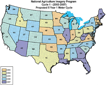
FIGURE 5.1 NAIP data collection forecast. SOURCE: National Agriculture Imagery Program. Available at http://www.fsa.usda.gov/Internet/FSA_File/2007_naip_timeline.pdf [accessed April 11, 2007].
5.2.3.3
U.S. DEPARTMENT OF AGRICULTURE NATIONAL AGRICULTURAL IMAGERY PROGRAM
The NAIP acquires imagery during the agricultural growing seasons in the continental United States. The goal is to deliver the imagery before the crops are harvested (Bethel, 2006). NAIP imagery is acquired under two sets of specifications: (1) 1-meter GSD imagery with a horizontal accuracy that matches within 5 meters of a reference point in existing orthoimagery, and (2) 2-meter imagery that matches within 10 meters of a reference point in existing orthoimagery.1 The geographic distribution of the U.S. Department of Agriculture (USDA) NAIP orthoimagery collected in 2006 is shown in Figure 5.2.
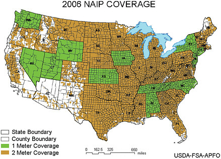
FIGURE 5.2 NAIP 1- and 2-meter GSD orthoimagery obtained in 2006. SOURCE: Bethel, 2006.
NAIP imagery products are available either as quarter quadrangle tiles or as compressed county mosaics. All individual tile images and the resulting mosaic are rectified to the UTM coordinate system, North American Datum of 1983 (NAD83), and projected into a single UTM zone for each county mosaic.
The 2-meter NAIP imagery is intended to support USDA programs that require current imagery acquired during the agricultural growing season but do not require high horizontal accuracy. One-meter products are generated when a compelling need for higher horizontal accuracy or a cost-share from a state partner is demonstrated. In either case, the orthophotos are rectified using best-available digital terrain models. USDA and NAIP contractors have expressed concern that in certain areas the digital terrain models available are not sufficiently accurate to produce orthoimagery meeting NDOP specifications. Furthermore, the NAIP program may eliminate the 2-meter product in the future, creating 1-meter orthophoto base maps of most of the county every year (Bethel, 2006). This will increase the demand for accurate elevation models to support the NAIP program.
NAIP 1-meter orthophoto products meet FEMA FIRM base map minimum specifications. NAIP 2-meter products and county mosaics are useful if 1-meter orthophoto
products are not available, but the 2-meter data do not meet the FEMA FIRM base map minimum specifications. The committee believes that the USDA NAIP program is the most up-to-date source of national orthophoto base map information in the United States that can be used to create FEMA FIRM base maps, although the NAIP program allows 10% cloud cover and is flown during leaf-on conditions, neither of which is allowed by FEMA standards. Thus, specific assessment of NAIP imagery is needed to determine if important features are obscured before use in FEMA FIRM base maps. The committee considers the continuation of NAIP very important, particularly as a component of Imagery for the Nation discussed below.
5.2.3.4
IMAGERY FOR THE NATION
The National States Geographic Information Council (NSGIC) is working with NDOP and the Federal Geographic Data Committee (FGDC) to create a new nationwide aerial imagery program called Imagery for the Nation that is to collect and disseminate standardized multiresolution products on “set” schedules. Local, state, regional, tribal, and federal partners will be able to exercise “buy-up” options (Table 5.1) for enhancements that are required by their organizations (NRC, 2003). The imagery acquired through this program will remain in the public domain and be archived to secure its availability for posterity (NSGIC, 2006).
This massive undertaking requires two separate, but well-coordinated programs. The existing USDA NAIP will be enhanced to provide annual 1-meter imagery of all states except Alaska. This program will typically collect natural color imagery during the growing season (leaf-on). A companion USGS program will obtain 1-meter imagery of Alaska once every five years. This program will also produce 1-foot resolution imagery once every three years for all states east of the Mississippi River and for all counties west of the Mississippi River with population densities ≥25 people per square mile. In addition, 50 percent matching funds will be available for partnerships to acquire higher-resolution, 6-inch imagery over urban areas identified by the U.S. Census Bureau that have populations of ≥50,000 and overall population densities of ≥1,000 people per square mile. This program will typically acquire natural color imagery during winter and spring months (leaf-off). Imagery for the Nation is predicted to save the taxpayer approximately $159 million every three years compared to traditional orthophoto data collection programs (NSGIC, 2006).
The committee strongly endorses the Imagery for the Nation concept, which is largely unfunded at present. The committee especially likes the flexibility inherent in the program that allows the various interest groups to buy up and obtain even higher-resolution orthoimagery if desired. If funded, the Imagery for the Nation program will ensure that high-spatial-resolution digital orthoimagery is obtained for the United States on a timely basis that can be used for FEMA FIRM base mapping.
TABLE 5.1 Imagery for theNation Program Specifications and Buy-up Options
5.2.3.5
LOCAL AND REGIONAL ORTHOPHOTO DATA COLLECTION
A tremendous amount of large-scale digital orthophotography is produced each year by photogrammetric engineering firms under contract to cities, counties, states, utilities, and other commercial firms. These data are typically collected for tax mapping, utility infrastructure placement, and transportation engineering investigations. These orthophoto products almost always meet FEMA FIRM base map minimum specifications (FEMA, 2003). The high-resolution orthoimagery datasets are of great significance for the development of FEMA FIRM base maps, especially in heavily urbanized areas.
5.2.4
Section Summary
The FEMA DFIRM specifications call for an image base map that meets the NDOP-USGS specifications for a 1:12,000-scale, 1-meter GSD digital orthophoto. Imagery sufficient to meet these specifications should be obtained whenever possible by passive remote sensing systems (e.g., aerial photography) using standard photogrammetric best practices. The committee endorses the Imagery for the Nation concept whereby aerial photography for the nation is updated on a predictable, systematic basis. In general, the committee concludes that existing orthoimagery and associated vector mapping data being employed in FEMA base mapping are of acceptable accuracy. The FEMA Map Modernization guideline appendixes provide some specifications of the compilation requirements for the vector data (FEMA, 2003).
5.3
COLLECTION OF DIGITAL ELEVATION DATA
5.3.1
FEMA’s DFIRM Specifications for Digital Elevation Data
FEMA’s DFIRM specifications for detailed study areas call for elevation data of 2-foot equivalent contour accuracy in flat areas and 4-foot equivalent contour accuracy in hilly areas, with elevation preferably mapped during the last 7 years. The committee’s study of available elevation data has shown that the average age of USGS topographic map sheets is 35 years and their equivalent contour accuracy does not meet the FEMA flood mapping standards. Approximately three-quarters of the streams completed under FEMA’s Map Modernization program define the spatial extent of flood inundation but lack the BFE data by which it is possible to judge whether a structure lying within the floodplain has a first floor elevation above the BFE. Thus, these maps do not fully support the floodplain management goals of the National Flood Insurance Program (NFIP). A new initiative of elevation data for the nation is needed.
In addressing the adequacy of remote sensing technologies to serve FEMA’s need for elevation data to support its mission of floodplain mapping, the committee evaluated three operational technologies: photogrammetry, lidar, and IFSAR. The strengths and weaknesses of these methods are outlined. In addition to the relative accuracies achievable with each technology, the committee considered cost-effectiveness of acquisition and updates required to keep these elevation data up-to-date.
5.3.2
Photogrammetry
5.3.2.1
STRENGTHS
-
Technology is mature and well understood.
-
Aerial photography can be used to generate multiple products such as orthophotos, planimetric maps, and digital elevation models.
-
Widely varying requirements for scale, detail, and accuracy can be addressed effectively by selecting an appropriate camera focal length and flying height.
-
Point spacing and breakline placement in photogrammetrically compiled digital terrain models (DTMs) can be optimized by the map compiler during manual collection.
-
Contours generated photogrammetrically can be edited by the map compiler to be cartographically pleasing, smooth, and easily interpreted by the map user.
-
Oblique aerial photographs analyzed using photogrammetric techniques can provide detailed information for floodway structures required for hydraulic modeling, but the cost-effectiveness compared to ground surveying is yet to be demonstrated.
-
The number of data providers ensures competitiveness in the marketplace in terms of quality, cost, and delivery schedules.
5.3.2.2
WEAKNESSES
-
Aerial photography for mapping should be acquired only during cloud-free, low-haze conditions with sun angle ≥30 degrees above the horizon.
-
Satellite imagery is subject to the same restrictions of cloud cover and sun angle. Orbital parameters of non-pointable sensors add yet another restrictive factor, making it difficult—if not impossible—to collect countywide or statewide data in a single mapping season. Satellites are useful for repeat coverage of localized areas in disaster response situations, where reconnaissance rather than mapping is the primary focus.
-
Tree canopy obscures the bare ground, making it difficult to map elevations accurately in vegetated areas. Aerial photography for terrain mapping should be
-
acquired during the leaf-off season of the year. This requirement, coupled with the sun angle requirement, results in very short windows for photo acquisition in many parts of the country. Areas obscured by tree canopy may be noted as dashed contours on a map; however, when assimilated into elevation models, the distinction is lost. As a result, elevation models are often less accurate in these localized areas than advertised by metadata.
-
Digital surface models (DSMs) created using photogrammetric autocorrelation techniques require significant manual editing to represent bare earth.
5.3.2.3
PHOTOGRAMMETRY SUMMARY
Photogrammetry is a mature technology capable of meeting FEMA’s accuracy requirements for elevation data in most types of terrain and vegetation. Consistent results and predictable accuracies can be achieved when the data provider follows professional standards and best practices, thereby minimizing the burden on the purchaser of elevation data to perform independent quality assurance and product testing.
The ability to map the bare earth in areas of dense vegetation requires acquisition during leaf-off conditions and depends on a clear view of points on the ground between trees from multiple photographic perspectives. Even in the best of circumstances, production of a detailed bare-earth elevation model requires interpretation by a skilled photogrammetrist. Areas of uncertainty are conventionally delineated as dashed contours, but there is no way to maintain the distinction of uncertainly when gridded DEMs are interpolated from the photogrammetric source data. This uncertainty is propagated into flood maps based on these DEMs, again without qualification or distinction.
Direct georeferencing and digital workflows have greatly reduced the time required to produce photogrammetric products; however extraction of bare-earth elevation models is still a very labor intensive, time consuming, and therefore, relatively expensive process. Photogrammetry alone is not cost or time effective enough to support the current demand for accurate, up-to-date elevation data to support the FEMA floodplain mapping mission.
5.3.3
Light Detection and Ranging (Lidar)
5.3.3.1
STRENGTHS
-
Lidar produces very-high-resolution three-dimensional point clouds in a wide variety of land cover types, including forests and urban areas, at accuracies equivalent to or better than photogrammetry at all but the largest map scales.
-
Lidar data can be acquired day or night. Data collection is not limited by sun angle.
-
Lidar data can be acquired in cloudy conditions, either by ranging to the ground through optically thin clouds or by flying beneath optically dense clouds. In either case, lidar is not affected by cloud shadows on the ground.
-
Lidar is able to penetrate to the bare earth in vegetated areas better than either IFSAR or photogrammetry. Acquiring data in leaf-off conditions is preferable, but it is possible to derive acceptable bare-earth elevation models from leaf-on lidar datasets when sufficient holes exist in the canopy.
-
Lidar intensity images can be used to aid in data interpretation and editing, eliminating the need for ancillary photography.
-
New developments in lidar instrumentation and processing make it possible to discriminate linear features and terrain breaklines in three dimensions, turning what has been considered a weakness of lidar into a potential strength.
-
Lidar data processing and feature extraction can be incorporated seamlessly into the production environment designed for photogrammetry. Photogrammetric mapping firms can leverage the skill sets of their workforce and their existing physical infrastructure, preserving their ability to respond quickly and effectively to customer requirements.
-
Terrestrial lidar can provide detailed information for floodway structures required for hydraulic modeling, but the cost-effectiveness compared to ground surveying has yet to be demonstrated.
-
The number of lidar data providers ensures competitiveness in the marketplace in terms of quality, cost, and delivery schedules.
5.3.3.2
WEAKNESSES
-
Lidar does not penetrate clouds. It is an ineffective solution for mapping in areas of the world that are perpetually covered with low, dense clouds.
-
The geometry of lidar is not rigidly determined as is a block of overlapping aerial photos. The statistically rigorous error models of photogrammetry cannot be transferred directly to lidar.
-
Existing guidelines and standards describing the accuracy of lidar-derived elevation models do not adequately address all potential sources of error.
5.3.3.3
LIDAR SUMMARY
Lidar is the most robust and cost-effective technology to address FEMA’s needs for elevation data to support floodplain mapping. Many operational projects have demonstrated lidar’s ability to meet FEMA’s accuracy requirements in diverse terrain and vegetation. However, sources of error and the statistical modeling of these errors are not known with
the same degree of rigor as they are for photogrammetry, which places a greater burden on the purchaser of lidar data to test and validate deliverables to gain confidence that project specifications have been met. While this represents a hurdle to be overcome in the widespread implementation of lidar for elevation mapping, sufficient resources exist in government, academia, and the private sector to solve these problems if guidance and a clear mandate are provided.
Organizations such as ASPRS, ACSM, the Association of State Floodplain Managers (ASFPM), AGU, the Management Association for Private Photogrammetric Surveyors (MAPPS), and the Open Geospatial Consortium (OGC) should be called on to assist public agencies such as FEMA, the USGS, the National Oceanographic and Atmospheric Administration (NOAA), states and local entities, and academia to define guidelines for professional practice and mapping specifications for application domains, such as floodplain mapping. For FEMA floodplain mapping, these specifications should address the need for 4-foot equivalent contour accuracy in complex, hilly terrain and 2-foot equivalent contour accuracy for the remainder of the nation as required by FEMA, in addition to the 1-foot equivalent contour accuracy in vulnerable coastal or very flat inland floodplains as recommended by this committee. Furthermore, data structures, formats, and interoperability standards should be developed for lidar mass points, three-dimensional breaklines on selected features (to be determined), hydrologically enforced stream networks and shorelines, triangulated irregular networks (TINs), and hydrologically corrected digital elevation models. Box 5.1 demonstrates the manner in which one state, North Carolina, adopted a statewide lidar data collection program. The system allows surveyors, engineers, and GIS professionals to work with an extremely detailed and large (file size) terrain dataset regardless of their respective computer system’s size, memory, or processor power.
The committee believes that there is further unrealized potential for lidar technology to contribute to floodplain mapping efficiency and accuracy. Techniques such as lidargrammetry could replace photogrammetry for the extraction of many three-dimensional structures. Land cover and surface roughness can be characterized by looking at the all-return lidar point data; bathymetric lidar can support coastal storm surge modeling and wave-height analyses; and terrestrial lidar may offer a cost-effective way to perform floodway structure surveys. As these technologies mature, FEMA should continue to evaluate their efficacy in the context of its floodplain mapping mission.
5.3.4
Interferometric Synthetic Aperture Radar
5.3.4.1
STRENGTHS
-
IFSAR collection can occur day or night, without regard to sun angle.
-
Overflights may take place in most cloud-covered conditions. IFSAR platforms
|
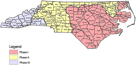
A Statewide Lidar Topographic Base Forms the Programs Framework A decision that the State of North Carolina made at the beginning of this project was to acquire a statewide high-resolution lidar-derived topographic base to form the foundation for the engineering analysis and the floodplain boundary accuracy. One complaint with older floodplain maps is that the floodplains do not match the topography and in some cases are mapped on hills instead of valleys. This is due primarily to inaccurate topography in the old studies. Added Value Benefit to the State of North Carolina from the Statewide Lidar While the benefits to accurately predicting and mapping the state’s flood hazards more than justify the investment in lidar, there are many added values for the lidar from program stakeholders. Examples of added values are listed below: Administration-Communication
Building Safety
Fire and Rescue
Forestry
Municipal Engineering
Department of Transportation
SOURCE: http://www.ncfloodmaps.com. |
-
operate at high altitudes, allowing rapid data acquisition over very large areas that can range between 50 and 150 square kilometers per minute.
-
IFSAR can collect high-resolution, accurate digital elevation surface models in many perpetually cloud-covered and densely vegetated parts of the world. While IFSAR cannot achieve the bare-earth accuracies of photogrammetry or lidar, it can provide good elevation data in places otherwise impossible to map at any resolution or accuracy.
-
RPI (repeat-pass interferometry) IFSAR can also be used to detect elevation change over large geographic areas caused by subsidence or seismic activity.
5.3.4.2
WEAKNESSES
-
Mapping in urban areas is challenging using IFSAR technology due to the complex scattering environment presented by buildings and other man-made features. Therefore, it is difficult to produce high-accuracy elevation models or imagery base maps in dense urban areas.
-
In vegetated areas, IFSAR rarely measures the ground surface unambiguously. As explained in Chapter 4, X-band IFSAR records elevation information from near the top of the canopy. P-band IFSAR records elevation information from near the bottom of the canopy. Regardless of the wavelength band, high-accuracy bare-earth elevation models are difficult to produce from IFSAR data in vegetated areas, in forests, or along stream channels.
-
IFSAR cannot produce high-resolution, high-accuracy DEMs or images equivalent to those produced by photogrammetry and lidar.
-
IFSAR does not provide for the extraction of breaklines along ridges and drains and around water bodies, which are important features to include when creating TINs for engineering analysis.
-
Competition in the marketplace is very limited in terms of quality, cost, and delivery schedules.
-
A bare-earth model is required for accurate engineering modeling and mapping of floods. The importance of achieving a bare-earth product is described in Section 3.10 of this report. IFSAR technology has difficultly obtaining bare-earth digital elevation models in dense urban and heavily vegetated areas.
5.3.4.3
IFSAR SUMMARY
IFSAR has matured sufficiently to be represented by a few commercial data providers but still relies heavily on government investment in research and technology development. IFSAR is not capable of achieving FEMA’s accuracy requirements for bare-earth elevation
data in most types of terrain and vegetation encountered in areas of interest to the floodplain mapping program. FEMA has sponsored several evaluations of IFSAR data and found them unsuitable due to the effects of vegetation in nearly all cases, particularly riparian areas along stream banks where bare-earth elevation data are critical for hydraulic modeling.
Exceptions to the general statement on the unsuitability of IFSAR data for floodplain mapping are (1) the State of Alaska, where perpetual cloud cover, extreme terrain, inaccessibility of services, and hazards to small, low-flying aircraft pose serious limitations to both photogrammetry and lidar; and (2) some rugged, barren areas of the western United States. In these areas, an IFSAR-derived DEM may be the most practical and cost-effective way to provide useful floodplain management and mapping information.
Development of IFSAR mapping systems requires a large capital investment, advanced computational infrastructure, and a specially trained workforce. While these statements can also be made about photogrammetry and lidar, the magnitude of the investment is substantially larger for IFSAR. Data providers are few in number; commercial IFSAR systems and processing methods are proprietary. One of the two commercial providers does not provide unrestricted access to its ISFAR-derived elevation data products as a general business model.
5.3.5
Sources of Elevation Data for FEMA Floodplain Mapping
The USGS began creating topographic maps in the 1920s and had largely completed that task by the 1990s. The USGS also interpolated contours from the 1:24,000-scale topographic map sheets onto an elevation grid at 1-arc-second (30-meter) resolution to form the National Elevation Dataset (NED); once-over coverage of the conterminous United States was completed in 1999. In recent years, the USGS improved the quality of the NED by including the stream and river lines from 1:24,000-scale maps in the interpolation and increasing the resolution from 1 arc-second to 1/3 arc-second (10 meters) in many areas. Where provided by state or local sources, 1/9-arc-second (3-meter) resolution elevation data derived from photogrammetry or lidar have recently been included. NED data are publicly available, and efficient distribution by the USGS supports widespread use throughout the geospatial user community. These data currently fulfill the National Spatial Data Infrastructure (NSDI) requirement for a framework elevation data layer, although many find the vertical accuracy of the NED insufficient to meet their application requirements. However, to date they are the best available elevation data for much of the nation.
The USGS relies on NED data to orthorectify aerial photography for the national DOQQ program. The USDA uses NED data to orthorectify NAIP aerial photography (discussed in Section 5.2). The gridded (raster) nature of the data makes it ideal for this purpose. In most cases, the vertical accuracy of the NED is sufficient for orthophoto rectification at 1:12,000 scale; however, USGS and USDA program managers and production
contractors alike can attest to the fact that significant effort goes into editing and correcting DEM problems in order to meet the orthophoto product specifications. Testing the NED against more than 13,000 National Geodetic Survey (NGS) control points resulted in a root mean square error (RMSE) of 2.34 meters, which is equivalent to 4.54 meters at the 95 percent confidence level (Gesch, 2006). While this accuracy is better than the quoted RMSE of 7 meters for USGS DEMs, it does not approach the FEMA requirement for 4-foot and 2-foot equivalent contour accuracy, or the committee’s recommended 1-foot equivalent contour accuracy for coastal areas (equivalent to 37-, 18.5-, and 9.25-centimeter RMSEs, respectively). FEMA flood mapping requires elevation data about 10 times more accurate than provided by the NED for detailed flood studies. The committee underscores the fact that the NED is a single large dataset composed of data from numerous sources with widely varying but systematic accuracies. Thus, although the overall RMSE of the NED is about ten times larger than the values FEMA requires, existing DEM coverage in many areas of the country may be of significantly better quality than the “overall” NED RMSE might imply.
Moreover, the accuracy reported in the DEM metadata is often a relative measure of how well the interpolated DEM fits the topographic map source, rather than how well it fits the ground. Overall, the accuracy field in FGDC compliant metadata was interpreted differently over time by numerous organizations and situations, and the accuracy statements are often questionable. On a topographic map, the vertical accuracy of any given point is related to the contour interval, which varies from map sheet to map sheet. All of these data have been converted to the same gridded digital format. The accuracy reported is a measure of how well the conversion was performed, and the actual accuracy relative to ground (in the year the original map was created) can only be estimated by reading the metadata to determine the contour interval of the source map and factoring in the conversion error.
Another problem with the NED is the age of the source data used to create the DEMs. Most of the elevation information originates from USGS topographic map contours, converted to digital form via scanning and interpolated to a regular grid. The age distribution of source data is shown in Figure 5.3. The major emphasis on topographic map creation occurred during the 1960s and 1970s, and the average date of origin of one of these maps is 1970. Thus, on average, topographic information contained in these maps is more than 35 years old, while FEMA flood mapping standards for detailed study areas call for data measured or considered for updating within the last 7 years, where possible.
Today, there are many producers of elevation data in the United States in addition to the USGS. Many of these producers are using lidar to create more dense and more accurate elevation data than are currently in the NED. Most of these datasets are available in the public domain. The USGS is implementing CLICK (Center for Lidar Information, Coordination, and Knowledge, http://lidar.cr.usgs.gov) with the intention to collect and distribute any lidar data that are publicly available nationwide. It is essential that these more current,
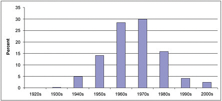
FIGURE 5.3 Date of creation of USGS topographic maps. SOURCE: EROS Data Center.
higher-resolution, higher-accuracy elevation data sources, collected by various producers, be considered for inclusion in the NED.
The USGS has established liaisons with state and federal agencies to foster data-sharing partnerships. A consortium of federal and state agencies, led by the USGS, comprises the National Digital Elevation Program (NDEP) whose mission is to establish digital elevation standards and requirements. The governance infrastructure for national elevation data, led by NDEP and currently implemented in practice as the NED, is analogous to the NDOP model for digital orthophoto imagery. The USDA is a major stakeholder in NDOP due to its compelling need to use imagery in support of the national crop insurance program. NDOP is following the guiding principles set forth by the Imagery for the Nation concept, insofar as individual agency budgets and policies allow. A parallel governance model for elevation could be created that (1) embraces FEMA as a major stakeholder due to its compelling need for current, accurate data to support the NFIP; (2) uses NDEP to drive development of standards and specifications; and (3) follows the principle of Elevation for the Nation described in Section 5.2.3. It is clear to the committee that FEMA has the most stringent requirements for seamless, nationwide elevation data in the federal user community. It is also clear that the USGS has experience in guiding the creation of framework datasets for the NSDI. Elevation for the Nation is a concept long overdue and urgently needed.
In the absence of a coordinated national effort, a number of states have initiated elevation mapping programs to meet a variety of needs. States such as West Virginia and Indiana have acquired elevation data to support digital orthophoto production, but these datasets, like the overall NED RMSE, fall short of FEMA accuracy requirements for floodplain mapping. For example, the West Virginia 1/9-arc-second datasets were compiled to the
accuracy of 10-foot contours, which do not meet FEMA’s accuracy requirements for 2-foot or 4-foot contours. Other states, such as North Carolina, acquired elevation data to support a statewide update of DFIRMs and, using state funds, exceeded FEMA’s minimum requirements by covering the entire state with seamless elevation data. These data have proven to be of great value to other state, counties, and local governments for orthophoto production, transportation planning, environmental compliance, and public works applications. Because the FEMA specification is the only public document that currently addresses elevation products derived from lidar, many other states are using it by default, even though they do not have a statewide agreement with FEMA for DFIRM updates. The USGS is making every effort to bring these statewide datasets into the NED; however, the lack of consistency from state to state will likely frustrate and challenge the user community for years to come.
5.3.6
Proposed Accuracy Specifications for Elevation for the Nation
The committee recommends a national approach to the acquisition of elevation data using lidar based on FEMA’s existing requirements for 2-foot equivalent contour accuracy in relatively flat terrain and 4-foot equivalent contour accuracy in rolling to hilly terrain. In addition, the committee recommends consideration of a 1-foot equivalent contour accuracy requirement in very flat terrain, both for inland floodplains and for coastal areas vulnerable to hurricane storm surges. The distinctions between very flat, relatively flat, and rolling to hilly are not well defined; therefore, assessing the impact of these recommendations on a seamless national program is difficult.
The committee requested the assistance of the Topographic Sciences Program of the USGS Center for Earth Resources Observation and Science (EROS) to clarify this issue. Using products from the Elevation Derivatives for National Application (EDNA) program, USGS produced the slope map of the continental United States, Alaska, and Hawaii shown in Figure 5.4. The red areas are essentially flat with zero slope; the dark green areas have slopes of less than 2 degrees; the light and reddish-brown areas are the hilliest with slopes of 10-15 and >15 degrees, respectively. For the continental United States, 51 percent of the land area has a slope of less than 2 degrees. Examination of tabular data that accompanied this map, summarized in Figure 5.5, indicates that 11 percent of the land area of the continental United States has slope equal to zero based on the 30-meter NED.
Issues other than slope should be considered when developing specifications such as cost-benefit with respect to flood risk and other uses of elevation data by federal, state, and local partners. Some remote areas may have no practical need for elevation data that are of greater accuracy than those already in the NED. However, slope information gives a good first approximation of the scope of a national elevation program. For planning and
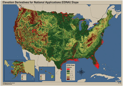
FIGURE 5.4 Slope map of the United States. SOURCE: Topographic Sciences Program, USGS Center for Earth Resources Observation and Science.
budgeting purposes, the committee recommends the development of 2-foot equivalent contour accuracy data as the nominal standard, 1-foot equivalent contour accuracy data in areas classified with near-zero slope, and 4-foot equivalent contour accuracy data in areas classified with slope of 10 degrees or greater. The reference to slope is the committee’s attempt to relate to FEMA’s requirements, which state that higher-accuracy elevation data are required in floodplains that are essentially flat (FEMA, 2003). For the continental United States, this would result in 11 percent of the land mass mapped at the highest accuracy level, 73 percent mapped at the standard level, and 16 percent mapped at the lowest accuracy. Specifications for Alaska and Hawaii should take into account additional challenges posed by weather and the environment, where lidar may not prove to be the most effective technology for acquisition of elevation data.
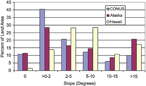
FIGURE 5.5 Percentage of land area in various slope categories. SOURCE: Topographic Sciences Program, USGS Center for Earth Resources Observation and Science.
5.4
CHAPTER SUMMARY
5.4.1
FEMA Map Modernization
The FEMA Map Modernization process (1999 to 2006) uses digital technology to provide improved flood hazard maps. The modernization guidelines suggest that participants use best-practice remote sensing technology to obtain much of the required base map imagery and elevation information. The committee believes that the information contained in FEMA DFIRMs is of significant value and is based on sound logic; the organization of the floodplain maps by “stream or coastal miles” is superior to organizing the FEMA DFIRM inventory according to typical “map sheets or panels.” The principal factor impacting the reliability of the predicted BFE and floodplain boundary delineation is the quality of the input digital elevation information. Because digitization of paper FIRMs perpetuates historical error and does not take into account recent changes in topography (elevation) due to development, erosion, or subsidence, digitization should be avoided in favor of collection of new elevation data to generate DFIRMs.
The committee concurs with FEMA’s desire to improve its method of flood risk determination and mapping prioritization. FEMA uses 10 logical geospatial risk factors analyzed
in a GIS to prepare the National Flood Risk analysis. Such risk assessment helps ensure that those geographic areas with the greatest population at flood risk are mapped first.
5.4.2
Orthoimagery
The committee found orthoimagery to be one of the most useful and important components of the FEMA DFIRM. Orthoimagery to be used as a FEMA DFIRM base map may be obtained by using passive or active remote sensing systems. Passive systems using aerial photography can be used to generate multiple products, including orthophotos, planimetric maps, and digital elevation models. While the creation of true orthoimagery from traditional digital orthoimagery is ideal, traditional digital orthoimagery derived from aerial photography is sufficient for most FEMA raster base maps. In contrast to passive systems, active orthoimagery systems can be used in conditions with cloud cover. However, radar orthoimagery can contain serious geometric errors that are not found in traditional optical orthoimagery, and the committee recommends that radar orthoimagery for FEMA base mapping applications be collected only when obtaining traditional passive optical orthoimagery is not possible.
Several sources of orthophotography maintained at different federal agencies can be used for FEMA floodplain base mapping. The committee endorses the Imagery for the Nation concept whereby aerial photography for the nation is updated on a predictable, systematic basis. In general, the committee concludes that existing orthoimagery and associated vector mapping data being employed in FEMA base mapping are of acceptable accuracy.
5.4.3
Digital Elevation Technologies
FEMA’s DFIRM specifications call for elevation data of 2-foot equivalent contour accuracy in flat areas and 4-foot equivalent contour accuracy in hilly areas, with elevation mapped during the last 7 years is preferred. The committee’s study of available elevation data has shown that the average age of the USGS topographic map sheets is 35 years and their equivalent contour accuracy does not meet FEMA flood mapping standards. A new initiative of elevation data for the nation is needed. The committee evaluated three operational technologies—photogrammetry, lidar, and IFSAR—to serve FEMA’s need for elevation data to support its mission of floodplain mapping.
Photogrammetry is a mature technology capable of meeting FEMA’s accuracy requirements for elevation data in most types of terrain and vegetation. However, extraction of bare-earth elevation models is still a very labor intensive, time-consuming, and therefore, relatively expensive process. Thus, photogrammetry alone is not cost or time effective enough to support the current demand for accurate, up-to-date elevation to support the FEMA floodplain mapping mission.
Lidar is the most robust and cost-effective technology to address FEMA’s needs for elevation data to support floodplain mapping. However, sources of error and the statistical modeling of these errors are not known with the same degree of rigor as they are for photogrammetry, which places a greater burden on the purchaser of lidar data to test and validate deliverables to gain confidence that project specifications have been met. Professional organizations with elevation mapping and surveying experience should be called on to assist public agencies such as FEMA, the USGS, NOAA, states or local entities, and academia to define guidelines for professional practice and mapping specifications for application domains, such as floodplain mapping. Specifications should address FEMA’s requirements for 4-foot equivalent contour accuracy in complex, hilly terrain and 2-foot equivalent contour accuracy elsewhere, as well as the 1-foot equivalent contour accuracy in vulnerable coastal or very flat inland floodplains as recommended for the nation by this committee.
IFSAR is not capable of achieving FEMA’s accuracy requirements for bare-earth elevation data in dense urban areas and dense vegetation encountered in many areas of interest to the floodplain mapping program. Exceptions to the general statement on the unsuitability of IFSAR data for floodplain mapping are (1) the State of Alaska, where perpetual cloud cover, extreme terrain, inaccessibility of services, and hazards to small, low-flying aircraft pose serious limitations to both photogrammetry and lidar; and (2) some rugged, barren areas of the western United States.
5.4.4
National Orthoimagery and Elevation Data Initiatives
The USGS has established liaisons with state and federal agencies to foster data-sharing partnerships. A consortium of federal and state agencies, led by the USGS, comprises NDEP, whose mission is to establish digital elevation standards and requirements. The governance infrastructure for national elevation data, led by NDEP and currently implemented as the NED, is analogous to the NDOP model for digital orthophoto imagery. The USDA is a major stakeholder in NDOP because of its use of imagery to administer farm and conservation programs. NDOP generally follows the guiding principles set forth by the Imagery for the Nation concept. A parallel governance model for elevation data could be created that (1) embraces FEMA as a major stakeholder due to its need for current, accurate data to support the NFIP; (2) uses NDEP to drive development of standards and specifications; and (3) follows an Elevation for the Nation concept.


