
2
Background and Current Setting
2.1
BACKGROUND: PREVIOUS NRC REPORTS
The National Research Council (NRC) issued a series of reports in the early 1980s related to land parcel data. These reports revolutionized the way the people think about local land records, the value they have to the nation, and the role of the federal government in developing systems to map those data. They not only focused on the technical issues, but examined the social, environmental, institutional, and economic issues as well.
As referenced earlier, the report titled Need for a Multipurpose Cadastre (NRC, 1980) envisioned a parcel mapping system that would support land titling, assessment and taxation, and land use management for optimal environmental and economic development. It retained primary responsibility for managing these operations with local government, but recommended state coordinating bodies and some level of federal financial support. The report also recommended that the federal government develop standards for use across the country and support academic centers of excellence to study and improve “land information science.” The recommendations from that report can be found in Appendix B.
The second study, Modernization of the Public Land Survey System (NRC, 1982), recommended improvement of the spatial location information of the Public Land Survey System (PLSS). A large amount of land in the United States, and in particular federal land, was originally surveyed under the PLSS, which established the township and range system. Although many parcel boundaries are legally tied to these original surveys, many of the monument markers from those surveys are lost or lack good locational information. The report recommended the formation of a federal surveying and mapping agency to coordinate the geodetic, cadastral, and mapping activities necessary for modernization of the PLSS. It also recommended the formation of an interagency working group with the “participation of all relevant federal agencies and interested groups at the state, local, and private sector levels to integrate the geodetic, cadastral, and mapping activities necessary for the modernization of the Public Land Survey System” (NRC, 1982, p. 4) to perform this function until the new agency could be formed. The third study, Procedures and Standards for a Multipurpose Cadastre (NRC, 1983), focused on the implementation of the recommendations in the 1980 report,
including the technical and organizational procedures that would have to be followed and the technical specifications for the components of a multipurpose cadastre. The 1983 panel continued to view the multipurpose cadastre as a key component of how government should fulfill its mission. To fund the multipurpose cadastre, the study recommended federal grants to counties (or their equivalents) to cover about 40 percent of the cost for the multipurpose cadastre. It estimated that the cost of a matching federal program would be $90 million per year over a 20-year period for a total federal contribution of $1.8 billion.
The NRC has produced a number of other reports that are relevant to the present study in that they continue to document the need for national land parcel data and the roles of various players in developing it. For example, Toward a Coordinated Spatial Data Infrastructure for the Nation (NRC, 1993) provides the basic details of the National Spatial Data Infrastructure (NSDI) and lists the parcel (cadastre) as one of the primary components. It provides a strong rationale for federal involvement, including “aboriginal land tenure; the federal government’s significance as a land owner; its role in real estate and asset/facilities management; its role in acquiring property for specific projects; various taxation roles; its regulatory role with respect to real estate financing, interstate commerce, agricultural support programs, environmental assessment, hazardous waste management, etc.; and civil defense and emergency preparedness roles” (NRC, 1993, p. 66).
Promoting the National Spatial Data Infrastructure Through Partnerships (NRC, 1994) and National Spatial Data Infrastructure Partnership Programs (NRC, 2001) focused on the need and value of cooperation among the various stakeholding partners. A Data Foundation for the National Spatial Data Infrastructure (NRC, 1995) highlighted the need for the federal government to coordinate integration of spatial data. It also suggested that there should be a single nationwide formatting system for cadastral data (NRC, 1995, p. 38).
Weaving a National Map (NRC, 2003a) examined the U.S. Geological Survey (USGS) concept of The National Map. This program was designed to replace paper USGS 1:24,000 maps with online maps containing the same data. A partnership of local, state, tribal, and federal sources would provide the raw material for this online system. The study committee raised the idea of including parcels and other critical data with this scheme. It also recommended retention of both a standardized medium-scale map and the original large-scale material.
Licensing Geographic Data and Services (NRC, 2004a) recognized the value of licensing data, even when they are available at no cost. Licensing allows local government to retain control over the use of its data, but this often conflicts with the principle that data are a public good. The report used a series of vignettes to show various ways of sharing data while maintaining control and recommended maximum use of standardized licenses.
GIS for Housing and Urban Development (NRC, 2003b) proposed that the U.S. Department of Housing and Urban Development (HUD) create an urban spatial data infrastructure that includes parcel-level data. The report also noted (NRC, 2003b, p. 46):
The creation of a nationwide parcel-level dataset will require the participation of local government, finance agencies including Fannie Mae and Freddie Mac, realtors, and market researchers. States and metropolitan/regional-level governments (for example, the Twin Cities in Minnesota) have created programs to create or modernize parcel-level data. Because there is no nationwide source of parcel-level data, costly duplication and gaps can occur.
The 2000 Census: Counting Under Adversity (NRC, 2004b) looked at the Census Bureau’s work with local government in updating its Master Address File (MAF) of residences and concluded that the partnership was flawed. “The Bureau should also give serious consideration to providing localities with updated MAF files” (NRC, 2004b, p. 149). For some communities, this file, complete with addresses and x-y coordinates, would be the only electronic means they have to map their parcels.
As the reports listed above indicate, there has been no lack of understanding or guidance over the past 27 years with regard to the development of land parcel data.
2.2
GEOSPATIAL DATA POLICY AND THE SPATIAL DATA INFRASTRUCTURE
Although the land parcel system that was envisioned in the 1980s reports has not developed, much has changed regarding the development of a spatial data infrastructure and the associated geospatial data policy that could influence the development of national land parcel data. The relevant changes are described in this section.
2.2.1
Circular A-16 and the Federal Geographic Data Committee
The creation of geospatial data and the desire to do it efficiently have been concerns of the federal government for more than two centuries. The Land Ordinance of 1785 defined the system of land surveys that denoted the lands to be sold or transferred to settlers. An executive order in 1906 “granted advisory power to the United States Geographic Board to review mapping projects to avoid duplication and to facilitate standardized mapping” (Office of Management and Budget [OMB], 2002). A more recent effort was the issuance of Circular A-16 in 1953 with the purpose “to insure that surveying and mapping activities may be directed toward meeting the needs of federal and state agencies and the general public, and will be performed expeditiously, without duplication of effort.” Circular A-16 was revised in 1967, 1990, and 2002. The 1990 version created the Federal Geographic Data Committee (FGDC), to consist of representatives from the federal agencies that use geospatial data, and gave it the responsibility of coordinating federal geospatial data activities. Furthermore, the 2002 revision included the following powerful statement (OMB, 2002):
Implementation of this Circular is essential to help federal agencies eliminate duplication, avoid redundant expenditures, reduce resources spent on unfunded mandates, accelerate the development of electronic government to meet the needs and expectations of citizens and agency programmatic mandates, and improve the efficiency and effectiveness of public management.
Figure 2.1 summarizes the evolution of federal geospatial data policy since the issuance of Circular A-16 in 1953.
One of the first tasks of the FGDC was to establish categories of geospatial data and to develop communities of interest for each of them. The most commonly used sets of base data were designated as framework data layers (geodetic control, orthoimagery, elevation and bathymetry, transportation, hydrography, cadastral, and governmental units). The FGDC established subcommittees with a lead agency to oversee the development of content standards for each of these themes (Figure 2.2), as well as for other commonly used themes as needed.
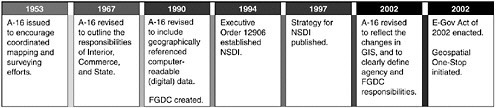
FIGURE 2.1 Summary timeline of U.S. federal data policy since 1953. SOURCE: GAO, 2003b.
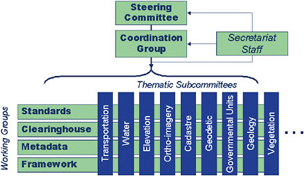
FIGURE 2.2 Organizational structure of the Federal Geographic Data Committee. SOURCE: FGDC website, http://www.fgdc.gov/organization [accessed February 13, 2007].
It is important to note that cadastre was established as one of the framework data layers. This elevates its importance and, according to Circular A-16, mandates that the federal government
-
Coordinate and work in partnership with federal, state, tribal, and local government agencies, academia, and the private sector to efficiently and cost-effectively collect, integrate, maintain, disseminate, and preserve spatial data, building upon local data wherever possible (OMB, 2002, 8(a)(5)); and
-
Search all sources, including the National Spatial Data Clearinghouse, to determine if existing federal, state, local, or private data meet agency needs before expending funds for data collection (OMB, 2002, 8(a)(10)).
2.2.2
Existing Federal Parcel Data Management Model
The committee found it useful to develop an interpretation of how the federal government could be operating under OMB Circular A-16 and the existing decisions of the FGDC. This interpretation is illustrated in Figure 2.3. This diagram relies heavily on the stated responsibilities that have been given to the Bureau of Land Management (BLM) under Circular A-16 to coordinate the cadastral framework layer for the NSDI. The responsibilities for these and other NSDI data themes were clearly articulated in Appendix E of Circular A-16 as described below. The lead department or agency identified for each data theme is indicated in parentheses.
Cadastral (Department of the Interior [DOI], BLM)
Cadastral data describe “the geographic extent of past, current, and future right, title, and interest in real property, and the framework to support the description of that geographic extent” (OMB, 2002). The geographic extent includes survey and description frameworks such as the PLSS,
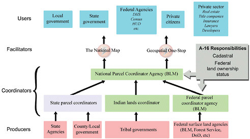
FIGURE 2.3 Interpretation of existing A-16 federal parcel custodian responsibilities.
as well as parcel-by-parcel surveys and descriptions. The land parcel is the fundamental entity in cadastral data.
Federal Land Ownership Status (DOI, BLM)
“Federal land ownership status includes the establishment and maintenance of a system for the storage and dissemination of information describing all title, estate or interest of the federal government in a parcel of real and mineral property” (OMB, 2002). The ownership status system is the portrayal of title for all such federal estates or interests in land. In this definition, the federal land parcel includes the mineral estate as well as the surface management activities. It is not unexpected that in the defined energy basins it is critical to have a good definition of the ownership of subsurface interests; however for the purposes of this report, the committee has focused on the surface management parcel as a first important step.
A literal interpretation of the Federal Land Ownership Status responsibilities suggests that BLM is mandated to serve as the federal land parcel coordinator. In a similar manner, as the designated steward for the cadastral framework layer, BLM would also appear to be designated to perform the functions of a national land parcel coordinator. The diagram includes a number of linkages from parcel data producers at the local, state, and federal levels to the federal and national coordinators and then on to the user community. It is important to recognize that many of these linkages are not just symbolic but actually exist. The most visible of these linkages are the National Integrated Land System (NILS) and the Geographic Coordinate Data Base (GCDB), which are discussed later in this chapter and in Chapter 4. Through these programs, BLM has established partnerships with other federal agencies, as well as state and local governments, to coordinate parcel data production and use. The diagram also includes a place for federal government facilitators between the national coordinator and the user community. The committee believes that The National Map and Geospatial One Stop programs of the National Geospatial Program Office in DOI are designed to fulfill that role
and are promoted as part of the federal enterprise architecture under its E-Government Initiative (as described in the next section). In fact, the North Carolina One Map program utilizes The National Map to serve parcel data for several counties. Therefore, if the extensive committees, OMB policy statements, executive orders, and standards efforts that have emanated from the federal government over the past century are to be followed, there is documented evidence that each of the components of Figure 2.3 is federally mandated and actually exists.
There are close relationships between parcel data and other FGDC data themes, and yet these layers generally have different theme coordinators and are developed separately. This is not the case at the local government level, where it would be standard practice to use parcel-based data either to create or to associate each of the following themes (theme coordinator is noted in parentheses). A better understanding of the relationship between parcel data and these data layers could help in development of all layers and avoid duplication of effort.
Buildings and Facilities (General Services Administration)
The facility theme “includes federal sites or entities with a geospatial location deliberately established for designated activities; a facility database might describe a factory, military base, college, hospital, power plant, fishery, national park, office building, space command center, or prison” (OMB, 2002). Facility data are submitted from several agencies, since there is no one party responsible for all the facilities in the nation, and facilities encompass a broad spectrum of activities. The FGDC promotes standardization of database structures and schemas to the extent practical. Buildings and facilities must rest on a parcel of land that has an owner, value, and use.
Cultural Resources (DOI, National Park Service)
“The cultural resources theme includes historic places such as districts, sites, buildings, and structures of significance in history, architecture, engineering, or culture. Cultural resources also encompass prehistoric features as well as historic landscapes” (OMB, 2002). Cultural features are located on land parcels; in fact, many sites are defined by the parcel boundary.
Governmental Units (Department of Commerce, U.S. Census Bureau)
“These data describe, by a consistent set of rules and semantic definitions, the official boundary of federal, state, local, and tribal governments as reported/certified to the U.S. Census Bureau by responsible officials of each government for purposes of reporting the Nation’s official statistics” (OMB, 2002). Many incorporated areas are defined by parcel boundaries; in fact many local governments track annexations on the basis of parcels. Many parcel databases include a field for the incorporated area, which is used for designation of service providers such as law enforcement. At a meeting of this committee, a Census Bureau representative stated that the back edge of parcels is preferred to block boundaries for defining Census designated areas.
Housing (HUD)
“HUD’s database maintains geographic data on homeownership rates, including many attributes such as HUD revitalization zones, location of various forms of housing assistance, first-time homebuyers, underserved areas, and race” (OMB, 2002). HUD has recognized that parcel data are critical to tracking information about housing units. HUD has numerous grant programs (as described in Section 3.1) for housing development and compliance issues that relate to specific land parcels, their owners, and their value.
2.2.3
Recent Geospatial Data Initiatives
Some of the most recent efforts to address issues relating to the coordination and funding of geospatial data are OMB’s Federal Enterprise Architecture (FEA) Geospatial Profile and Geospatial Line of Business (GLoB). The purpose of the FEA is to “identify opportunities to simplify processes and unify work across the agencies and within the lines of business of the Federal government.”1 The FEA now has a Geospatial Profile in draft and available for use that establishes a framework for more effective use and management of geospatial data and services as part of agencies’ enterprise architectures. (The development of enterprise architectures is a process now commonly being used to better manage and align an organization’s business processes.) It describes how agencies can leverage geospatial data and technologies to enhance service delivery and mission accomplishment.2 The GLoB is one of several lines of business within the FEA, with the goal of facilitating the identification of duplication of investments and opportunities for collaboration. The description of the GLoB is as follows:3
To further refine the opportunities for optimizing and consolidating Federal geospatial-related investments to reduce the cost of government and, at the same time, improve services to citizens. Cross-agency coordination of geospatial activities can identify, consolidate, and reduce or eliminate redundant geospatial investments. Developing the Geospatial Line of Business (LOB) will result in a more coordinated approach to producing, maintaining, and using geospatial data, and will ensure sustainable participation from Federal partners to establish a collaborative model for geospatial-related activities and investments.
The committee believes that the GLoB could have a major impact on the way land records are managed and funded in the United States if it addresses the common need for land parcel data across many federal agencies and reduces the current duplication of effort. With respect to an intergovernmental model for parcel development and maintenance, the committee believes the following transformational activities proposed by the GLoB are significant (FGDC, 2006, p. 23):
-
Holding data stewards responsible and accountable for key data sets;
-
Facilitating data acquisition requirements through the Fifty States Initiative;
-
Developing and implementing common grants language for geoinformation and services; and
-
Increasing intergovernmental coordination activities.
The GLoB recognizes the need for the NSDI to include nonfederal data and specifically endorses the Fifty States Initiative developed by the National States Geographic Information Council (NSGIC) in cooperation with the FGDC. The Fifty States Initiative focuses on developing strong state coordinating bodies to organize and communicate effectively with their state agencies and local government, thereby eliminating waste and improving efficiency. Coordinating state efforts with those of the federal government delivers similar value. The state coordinator’s work includes requiring standards and encouraging the sharing of data, thereby developing the NSDI across all levels of government.4
Finally the FGDC is in the process of establishing a new National Geospatial Advisory Committee (NGAC). The NGAC will have members from all sectors involved in geospatial data matters,
|
1 |
For information on the FEA, see http://www.whitehouse.gov/omb/egov/a-1-fea.html [accessed May 18, 2007]. |
|
2 |
For information on the Geospatial Profile, see http://www.cio.gov/documents/FEA_Geospatial_Profile_v1-1.pdf [accessed May 18, 2007]. |
|
3 |
See http://192.136.12.215/lineofbusiness/geospatiallob.cfm [accessed March 15, 2007]. |
|
4 |
For information on the NSGIC Fifty States Initiative, see http://www.nsgic.org/hottopics/50states_initiative_handout.pdf . [accessed June 13, 2007]. |
including all levels of government, private industry, nonprofits, and academia. Its purpose is to provide advice to the federal government on national geospatial data programs and the NSDI.
2.2.4
Future Trends and Conclusions
It is clear that the concept of a spatial data infrastructure (SDI) and associated geospatial data policy has evolved significantly since 1980. In a recent article, Rajabifard et al. (2006) provide a useful comparison of the United States with the rest of the world in this area. They suggest that the United States and other developed nations have already progressed through two evolutionary stages and are entering a third stage. They categorize the first stage (1990-1998) as one dominated by products produced by a national or federal government influence. During the second stage (2000-2006) there was a shift to process-oriented developments dominated by an increased influence of subnational groups and the private sector. They suggest that the next stage will shift to the demands for a virtual environment that will be dominated by subnational and private sector activities or “people-relevant” data. The role of national governments in this next stage will change (Rajabifard et al., 2006, pp. 733-734):
Although national governments will continue to play a coordinating role within SDI development, sub-national governments and the private sector are taking on the operational role within SDI development due to the increasing need for maintained and up-to-date large-scale people relevant spatial information.
In summary, there is ample evidence that the federal government has attempted to better coordinate its geospatial activities for more than 100 years. These efforts have accelerated since the 1980s with the advent of digital geospatial data. Recent policy directives emphasize that the federal government is mandated to coordinate the development of important national geospatial data sets, including land parcel data. By including cadastral data as a framework layer of the NSDI the federal government has acknowledged the importance of parcel data. There is also evidence that BLM has been designated important responsibilities to serve as a coordinator of parcel data for lands owned by the federal government and of parcel data produced by all levels of government that are needed to meet federal programmatic needs. Although nationally integrated land parcel data do not exist, if the trend suggested by Rajabifard et al. (2006) is correct, the next phase of the SDI will be focusing on large-scale, people-relevant data, which certainly must include parcel data. Because of the vital role of local and state governments in parcel data, and the emerging role of the private sector (as described later in this chapter), partnerships between the various levels of government and the private sector will be key to developing national land parcel data. Recent efforts of OMB and its GLoB initiative to promote partnerships with state government seem to reflect this trend. There are already existing partnerships that can be expanded, reinvigorated, or provided new resources. While there may also be new partnership opportunities, the key is likely to provide opportunities to fulfill the potential of existing relationships and achieve levels of cooperation that have not been possible in the past.
2.3
TECHNOLOGY CHANGES
To assess the feasibility of maintaining a national approach to parcel data in 2007 it is useful to examine how technology for the collection and use of parcel data has evolved over the past quarter of a century. Of course, the rapid advances in geographic information system (GIS) technology have had an immense impact on parcel data collection and on the evolution of conceptual models themselves. However, more recent advances in technologies that didn’t even exist in 1980, such as web technologies and location-based services, are also having a profound effect.
2.3.1
Geographic Information System Technology
In 1980s-era parcel systems, data records were accessible only through nongraphic terminals directly connected to a stand-alone mainframe computer. Graphic input and output devices were extraordinarily expensive. Hard-copy maps were produced on slow pen plotters. The color raster displays on every home computer today were found only in dedicated scientific applications such as weather forecasting and remote sensing. In 1980, actual creation of the parcel data typically involved manual digitizing or tracing of existing tax maps. This was a tedious and error-prone process. Therefore, the decision to invest in a computerized system to create and manage land parcel data represented a major financial and institutional commitment. Nevertheless, there were some excellent pioneering efforts based on sound enterprise views of the importance of parcel data. For example, DuPage County, Illinois, was identified as an example of a local government that had implemented a parcel-centric system for integrating information (NRC, 1983) The cost of the DuPage system in 1983 was estimated to be $814,058 ($1,679,608 in 2007 dollars). In other words, a medium-size local government5 would have spent the equivalent of $1.6 million to purchase and maintain a multipurpose cadastre system with extremely limited functionality compared to modern systems that are truly integrated into a local government information system. This might be contrasted with the recent investment of $200,000 in Roseau County, Minnesota (Harren and Johnston, 2006), for a robust system based on current personal computers, servers, and Internet capabilities.6
Conceptual Models for Parcel Data
Another useful way to examine the changes in the way that parcel data have been created and managed over the past 27 years is to examine the conceptual models, or the “stack of layers,” used to represent geographic information within a local government information system.
Multipurpose Cadastre
The 1983 NRC report envisioned the relationship between parcel data and other data themes as digital versions of a registered set of transparencies that were manually registered with a set of pins (Figure 2.4).
This stack of layers provides a view of how parcel data (represented by the “property lines layer”) are interrelated with addresses, floodplains, and zoning. This model reflected the state of the art at that time. In effect, each of these layers was created and managed as an independent theme, often at different scales. These layers may have been built on a firm foundation of geodetic control and may have been visually overlaid and inspected, but in 1980 it was difficult to draw parcel maps in relation to the other themes. More importantly, the GIS software tools at the time would not have provided very robust support for decision making. For example, it was difficult to determine automatically which land parcels were located in the floodplain or to generate the land area affected by flooding, although some prototype systems were being developed.
Land Information Systems (LISs)
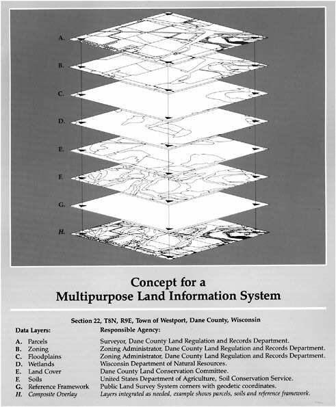
Throughout the 1980s the concept of the multipurpose cadastre envisioned in the 1980 NRC report had evolved in many local jurisdictions within the framework of an LIS. Dane County, Wisconsin, was one of the major testing grounds for building an LIS. Chrisman and Neimann (1985) presented an early version of a parcel-based layer model for the Dane County Land Records Project in 1985. This model emphasized the importance of a digital map overlay to integrate parcel data with other layers such as zoning, floodplains, and wetlands. Over the next few years the concepts
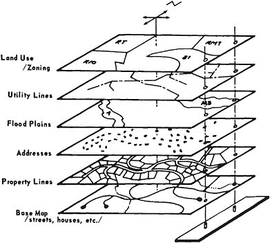
FIGURE 2.4 Stacked data layer diagram from the 1980s. SOURCE: NRC, 1983, p. 42.
and technologies behind this model matured. Many individuals involved in these efforts helped prepare the massive 25-chapter Multipurpose Land Information Systems: The Guidebook (Brown and Moyer, 1989 [NB: many of the chapters have dates of 1992, 1993, and 1994]). The guidebook was written to address many of the implementation aspects not addressed in the 1980 NRC report. Included in this guidebook was the stack of data layers for the town of Westport in Dane County (Figure 2.5). This diagram was widely regarded as the classic example of a multipurpose LIS. It is important to note that this model is a true intergovernmental one. In fact, Moyer (1990, pp. 7-15) made the following comments about what the diagram represents: “Building an LIS that is complete, comprehensive, and responsive requires the cooperation of all organizations that are organized vertically, to ensure the horizontal benefits of LIS are fully realized.” In this model, the parcel layer sits on top of the stack and is maintained by county surveyors.
The layers were actually digital representations (often at different scales). They were maintained independently, but it was possible to perform digital overlays to extract information. GIS software provided powerful tools to support decision making. For example, tabular and graphical information could be generated about how individual pieces of property interrelate with floodplains, soils, slopes, and other geographically registered information that is often maintained by other organizations.
The term multipurpose cadastre was eventually replaced by the concept of multipurpose LISs, for several reasons. One, the name was confusing to people; LIS is easier to understand, and the term multipurpose cadastre was used very little by Epstein and Brown (1989). Second, the multipurpose cadastre required linking natural resources and other land attributes to the parcel. Because
of limited storage capacity and ability to rectify and reproject these other maps in 1980, all of these linkages were to be done during the establishment of the system (i.e., before digitizing). Therefore, the fundamental difference between a multipurpose cadastre and a multipurpose LIS was the data structure. In the multipurpose cadastre, all themes (e.g., land use, soils) were recast into a parcel polygon. This limits all questions to the parcel. The LIS concept evolved when there were improved techniques for registering and manipulating the many data layers and themes. The parcel becomes one of those themes. Much of this evolution was already under way by the time of the 1983 NRC report as can be seen by comparing conceptual diagrams from the two reports.
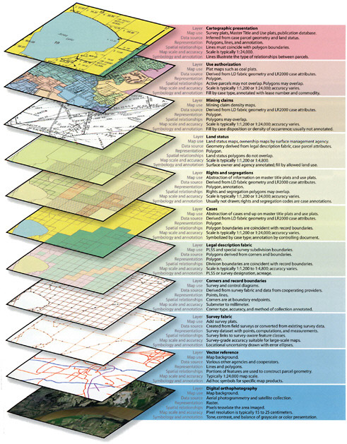
Modern Data Models
In the current age of information systems there is widespread appreciation that GIS applications have moved to a much higher level of granularity or resolution than was possible in 1990 or even 2000. This change represents a shift in emphasis that has had a major impact on the relationship between federal mapping organizations and local government. Local governments no longer struggle to ingest federal data or to digitize existing maps. Instead, they must deal with the complex problems associated with creating and maintaining very-high-resolution information that is derived from locally created information from surveys, legal documents, imagery, geocoding, and a wide range of field-based operations. These requirements have resulted in rigorous specifications for a parcel-based data model. In the United States, the development of this data model has been fostered by the FGDC Subcommittee for Cadastral Data (Figure 2.6).
In the contemporary model, each parcel is a unique entity that exists and must behave within a general framework that supports a wide range of applications and business functions. Parcel data become directly integrated with other themes and do not just float as an independent layer. Parcel boundaries are directly impacted by changes in other information. For example, the geographic position of all parcels may change on the basis of improved survey measurements. Parcel boundaries could be adjusted if a new road impacts the right of way. The parcel boundaries must also conform to a set of topological rules that impact how new parcels can be added and where utility lines can be run to connect to structures. At the same time, other themes that are dependent on parcel representations such as land use or zoning are synchronized with parcel boundaries. In other words, as parcels are created they can be adjusted to align with geodetic control monuments and rivers or other controlling features. In turn, dependent features such as political boundaries can be fit to the newly adjusted parcel boundaries.
Several software vendors and consultants have developed software tools and related procedures to implement this type of model. One software company provides a detailed conceptual depiction of the modern parcel GIS data model (Figure 2.7). The model clearly demonstrates how parcel production has evolved with changes in technology. This model is built on a firm foundation of very-high-resolution orthophotography, legal descriptions, and field measurements. The ability to translate the legal description of a parcel into a geographically defined polygon registered to points on the earth’s surface makes this model possible. As coordinate geometry (COGO) and advanced optical character recognition become standardized and cost-effective, a greater number of parcel programs have decided to create parcels from the legal descriptions. For example, DuPage County, Illinois, which was cited in the 1980 report, has entered 100 percent of all of its parcels using COGO procedures.
An example of a current system that has adopted the parcel GIS data model is the National Integrated Land System. NILS is a joint project between the Bureau of Land Management, the U.S. Forest Service, several state and local governments, and private firms to provide a seamless representation of federally managed lands. NILS is billed as “the first step toward providing a common solution for the sharing of land record information within the government and the private sector… [it] implies the development of a common data model and a set of GIS tools that unify the worlds of surveying and GIS” (Cone, 2003, p. 227). The goal of NILS is to “improve the accuracy and quality
of data so as to create standard land descriptions and cadastral data that can be used by anyone.” In effect, NILS is an effort by the federal government to utilize a structured intergovernmental model based on the type of firm foundations identified in 1980 and 1992. From a technological and organizational perspective, NILS is being created using several things that did not exist in 1980 or even 1990. These include (1) off-the-shelf GIS software to handle the complexities of parcel data including the input of measurements from surveyors; (2) the FGDC Cadastral Data Content Standard and the FGDC Content Standard for Digital Geospatial Metadata; and (3) object-oriented software (Figures 2.8 and 2.9).
While this discussion has shown how GIS-based parcel data systems have evolved in the last 27 years, nationally integrated land parcel data are unlikely to need the level of complexity shown here in terms of GIS capabilities. The greater challenge for national data will be in accessing source data and disseminating them effectively, which relate to technologies addressed in the next section.
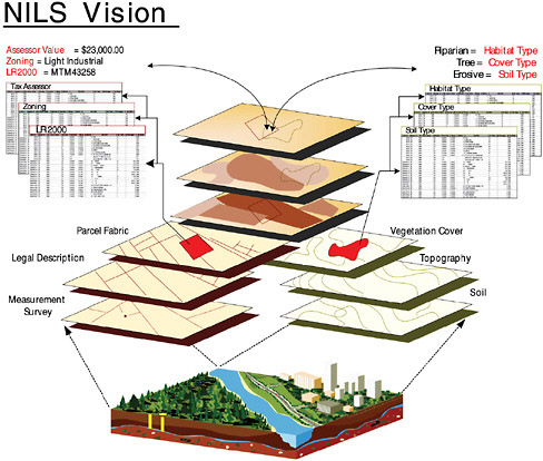
FIGURE 2.8 National Integrated Land System. SOURCE: BLM, 2001.
FIGURE 2.9 NILS conceptual data model. SOURCE: BLM, 2002.
2.3.2
Web-Based Technologies
While GIS technologies have revolutionized the development and use of land parcel data, the advent of the Internet and web-based technologies has revolutionized the ability to disseminate, access, and link data. These technologies did not exist in 1980. The current capabilities of web-based services are illustrated by the system in use by the Chicago Metropolitan Agency for Planning, described in Box 2.1.
It is clear from Box 2.1 that serious decision support is dependent on a parcel database that is maintained by transactions, totally integrated across departments and jurisdictions, and fully supported by the latest Internet-based applications. This example demonstrates what is possible even in a major urban area. Open Geospatial Consortium web services have had tremendous growth within the past few years. The Census Bureau has adopted the WebTIGER—a web feature service interface allowing requests for geographic features across the web. However, even the most powerful access systems provide little benefit if they deliver data stored in inconsistent formats or data incompatible with the user’s application.
The implications of these web services for nationally integrated land parcel data are huge. In 1980 the ability to instantly access data on distributed servers had not even been conceived. Web services now make possible a decentralized network that allows a single-point access to land parcel data from multiple producers that continue to reside on the server where they are developed and maintained.
2.3.3
Location-Based Services
An emerging geospatial growth area is that of location-based services. The development of global positioning system (GPS) technology provided the ability to determine the geographic coordinates of any location. More recently, the process of automated address locating, or geocoding,
|
BOX 2.1 Chicago Metropolitan Agency for Planning Program City, county, regional, state, and federal agencies can make data available via web services that can be called by other servers at any time. This means that all partners can incorporate the most current data available into their own data systems. The data can be fetched as needed from the most authoritative source, then displayed on a web form, pulled into a predictive model, or used to calculate aggregate statistics. Users of our data system conduct property surveys for a variety of zoning, economic development, and other purposes. They walk up to the property with a smart phone, open a browser, select a property address from the list and click “Go”. Our web server issues consecutive data requests to various county and city services, renders the resulting data into HTML, and sends the whole batch down to the user’s browser. All within less than a second. The latest data, straight from the source. Since the Assessor’s teams continuously sweep through various parts of the county updating assessments, this is an important feature. Web services are not just for data exchange with external partners; they also work well for cross-departmental sharing. A city government wishing to provide a one-page parcel profile for use by city employees might create a web form that pulls together property ownership, permits, physical characteristics, business licenses, court records, crime data, any public financing or subsidies, historic value of the structure, building condition and many other attributes. But typically these bits of information are housed and owned by various data stewards across several departments. A series of light-weight web services could be deployed as interfaces between departments. SOURCE: Sanders, 2006. Reprinted with permission from the Urban and Regional Information Systems Association, http://www.urisa.org. |
is the core of a host of location-based services that have become a common part of our everyday life. It is hard to overestimate the importance of the automated address matching systems. For example, MapQuest generates millions of maps and directions every day.7 The capability is used for practical decisions such as finding the location of a party, a hotel, or the closest drug store. United Parcel Service and FedEx drivers use the same function to deliver a package to your house, and the local emergency 911 dispatcher uses it to route an ambulance. This has created a booming interest in digital geographic reference files that accurately locate addresses with geographic coordinates, and many private industry companies have been stepping up to fill this need, such as NAVTEQ and Tele Atlas. NAVTEQ and Tele Atlas also provide detailed street centerline files that are an alternative representation of street segments available from the Bureau of the Census in its Topologically Integrated Geographic Encoding and Referencing (TIGER) data set. The customers for these reference files include major U.S. companies such as Microsoft, Google, and MapQuest that support location-based services for thousands of clients. Firms that support location-based services are generally concerned only about the association between a street address and geographic coordinates, not about attributes of the building or property. However, because address location and parcel data are inextricably linked, this growing trend of generating address location data is having a huge impact on the development of parcel data as well and, thus, needs to be discussed here. There is another segment of the commercial market that has been concentrating on providing digital data sets with detailed information about property. (Chapter 4 provides a more detailed description of the status of private sector development of parcel data sets.) Customers for these products are concerned about various aspects of insuring, financing, exchanging, and developing property. They include major
insurance companies, lending institutions, real estate brokers, and title companies. Since there is such a close tie between the parcel and its address, there is beginning to be some overlap between the generation of these two types of data sets and even the companies that are producing them.
The origins of automated address locating systems began about 40 years ago and were implemented by the Census Bureau for the 1970 decennial Census. The original Dual Independent Map Encoding (DIME) files provided the basis for the first large-scale system that could assign an address to an estimated location along a street segment and place it into the correct block. With the TIGER system in 1990 the Bureau provided a public domain set of street segments with associated address ranges that could be used across the nation. By using the TIGER street segments and address ranges, the location of specific addresses can be determined by proportioning an address along the length of the street. These resources fueled an entire industry and made it possible for firms such as Tele Atlas to develop a successful business application. However, the location of an address based on TIGER is simply an estimate that is directly related to the accuracy and completeness of the representation of the streets in TIGER. There is no information in a TIGER line segment about the actual addresses or their locations. A major goal of the TIGER modernization program is to improve the positional accuracy of the street centerline base and to replace this address interpolation method with a specific one-to-one address matching system for the 2010 decennial Census (discussed further in Chapter 4). Since these streets also form the block boundaries, their adjustment will cause dramatic changes in the geography of the census blocks as well. The legacy of the DIME and TIGER approaches to automated address matching can still be found in most of the current commercial geocoding systems.
Figure 2.10 provides an example of these concepts and the intersection between applications that focus on locating the street address and those that require information about the property. Using an actual address (116 Ila Lane, Columbia, SC 29206) the figure portrays various ways in which this address is located in a series of parcel data and automated address locating applications. Using a standard web browser the address can be entered into the Richland County, South Carolina, GIS web mapping system (Richland Maps) to retrieve the information displayed in Figure 2.10A, including the parcel boundary, the building footprint, and a high-resolution (one foot) natural color orthophotograph. This representation is used by local government as a close approximation of how the parcel is portrayed on a tax map and is linked directly to the official assessor information for the property (Figure 2.11).
Figure 2.10B shows how the address number of 116 is matched to a single street segment in the Census TIGER data. The address is estimated to be on the right or even-numbered side of a street that has a low address of 100 and a high address of 198. The exact location is interpolated to be 16 percent of the length of the street segment. Figure 2.10C demonstrates that the TIGER street centerlines need considerable adjustment to prevent them from intersecting the parcel boundaries for the block containing the sample address.
The problems associated with interpolation of street addresses are readily apparent from the next two maps in Figure 2.10. Two of the three major web-based services (Google Maps [Figure 2.10D] and MapQuest [Figure 2.10E]) placed 116 Ila Lane at the wrong end of the street, about 100 meters from the actual location of the house. This error is likely the result of reversing the “from and to” directions of the address range. Microsoft (Figure 2.10F) just recently updated their information for this area and now places the location more accurately. Nevertheless, with any of these services, it would still be necessary to reference the actual street number on the door or mailbox. The need for accurate geocoding has become especially obvious because of the extremely high resolution imagery that is now available in many local government GIS operations and even commercial applications such as Google Earth. Figure 2.10G shows recent imagery that is available for the sample address in Richland County, South Carolina. This image consists of pixels with a resolution of about 4 inches (note the automobiles), and the house location is clearly visible in the yellow circle. Nevertheless,
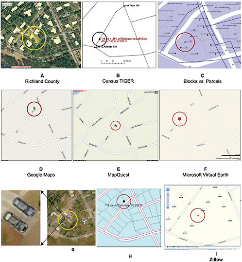
FIGURE 2.10 Various locations of a sample address through different automated address matching applications. SOURCES: (A) Image courtesy of Richland County, SC, www.richlandmaps.com; (B) data courtesy Census Bureau; (C) data courtesy of City of Columbia, SC, Census Bureau; (D) image courtesy Google Maps, copyright NAVTEQ; (E) Map content (c)2007 by MapQuest, Inc., MapQuest and the MapQuest logo are registered trademarks of MapQuest, Inc., used with permission; (F) image courtesy Microsoft Virtual Earth; (G) images courtesy of Pictometry, Inc.; (H) parcel data courtesy of City of Columbia, SC; (I) courtesy Zillow, map data copyright 2007 NAVTEQ, GlobeXplorer and Suppliers, and Proxix. Parts (D), (E), (F), and (I) (c)2007 NAVTEQ. NAVTEQ is a registered trademark of NAVTEQ Corporation. NAVTEQ map content is used with permission.
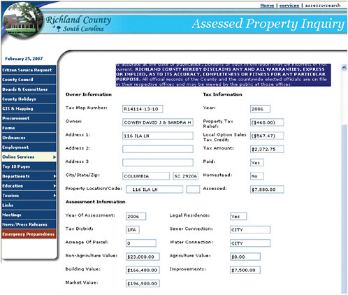
FIGURE 2.11 Detailed property information for the sample address. SOURCE: Richland County, South Carolina, Assessor’s website: http://www.richlandonline.com/services/assessorsearch/ assessorsearch.asp [accessed May 29, 2007]. Image courtesy of Richland County, SC, www.richlandmaps.com.
the address geocoding service based on interpolation (available with the interface for viewing the imagery) not only placed the address at the wrong end of the street, but placed it on the wrong side of the street, thereby putting it in the wrong census block (Figure 2.10H). It is evident that errors such as these are unacceptable for an emergency 911 application, law enforcement officers conducting a “drug bust,” any vehicle navigation system that announces “you have arrived,” or home owners who need to determine whether they are in a 100-year floodplain. Clearly this is also unacceptable for any real estate oriented application that must identify the correct house. In order to meet this requirement, Zillow.com has obtained at least a point-level representation of the location of 70 million houses. The sample address demonstrates this functionality in Figure 2.10I. (Note that Zillow.com shows aerial imagery and parcel information for many areas, although it is not available for this particular location.)
The need to improve the address locating system is well known and being addressed not only by the Bureau of the Census but also by the private sector. The importance of accurate address
location systems is highlighted by a recent quote from William Gail, the director of Microsoft’s Virtual Earth program (e-mail to D. Cowen, May 1, 2007):
While geocoding based on interpolation of address ranges has been adequate for initial needs, it is far from satisfactory in the long run. In fact, even parcel identification is insufficient for many of the emerging internet needs, as a parcel may contain several buildings for which separate identification is desired. Microsoft Virtual Earth recently introduced rooftop geocoding to relate addresses to building locations, ensuring that addresses correspond properly to the relevant buildings. This is the most accurate geocoding currently available for applications such as route-finding, and we continue to improve our capability in this area…. Microsoft depends primarily on vendors to supply the most accurate possible information. At the same time we recognize that local governments often have the best first-hand knowledge of the current situation on the ground. Geocoding is likely to represent an ongoing challenge, both in the collection of raw data and in the algorithms that extract information from the data in response to user queries.
In summary, the information about a single address suggests that the backbone of nationwide parcel data already exists in the private sector and that several firms are actively competing to complete wall-to-wall coverage. This need is fueled by major firms such as Microsoft that plan to have “rooftop”-level representation of each address in the United States. Completing a point-level representation of parcels for improved address location is much easier than assembling full polygon representation of parcels and their associated characteristics. Nevertheless, there is considerable activity in the market for comprehensive parcel data and some fairly aggressive competition. Within the public sector the Census Bureau is also completing a nationwide point-level representation of all developed parcels; however because of legal restrictions, it will not be placed in the public domain. This is discussed further in subsequent chapters.
2.3.4
Future Trends
While a number of jurisdictions already offer web access to parcel databases, there is a benefit to creating a nationwide system or service in accordance with internationally recognized standards. The potential for people in very different places to access, view, and manipulate the data using the same interface has real promise in terms of driving new markets, encouraging employment mobility, and influencing the way we think about the information elements of accountable government. We have moved into an age where the impact of embedded GPS and “standard position” are just beginning to have the same impact as the introduction of pocket watches and “standard time” did back in the 1880s. It can be argued that while standard time was largely an outcome of “tech-push” (put in place largely because of the demands of the railroad and quicker communications via telegraph), it in fact changed the way in which people and groups over short and long distances organized their time. While standardized position is also a creation of tech-push, its influence—in terms of locating people and things, knowing where they have been, and knowing how long it will take them to get from their current location to a specified point—is now also starting to change the way in which organizations and people manage their time and their activities.
Organized and accessible land records will play an important role in what is becoming known as the global knowledge economy. The emergence of this knowledge economy has created a very competitive local government environment and is changing the way governments attract and retain businesses in their community. No longer can governments rely on “bricks-and-mortar”-type incentives, but they must find creative ways to market and promote their community. To this end, an organized land parcel data system allows government to assess and communicate the impact of changes in a more effective manner. In addition, access to online government content presents a more transparent form of government and thus supports a competitive advantage that one local
government may have over the next. The same could be said for state and national government levels as well; therefore nationally integrated land parcel data will become increasingly important as this global knowledge economy evolves.
2.4
SUMMARY
As the sections in this chapter have shown, since 1980 a great deal has occurred in terms of the guidance, geospatial data policy, and technological changes that have a direct influence on the development of national land parcel data. So the question remains, Why has the vision laid out in 1980 and the subsequent reports not been achieved? Technologically, the NRC panel in 1980 could point to existing systems that were used to manage parcel data in a digital environment, and although the panel stated that it did not see technology as a barrier, it was overly optimistic about what could be accomplished with the technology at that time. “Availability of technology” is not the same thing as a robust infrastructure that enables the average citizen in many different locations to be able to do something cheaply and transparently. It has taken a couple of decades to put the infrastructure in place—the advent of the Internet, the standards, the ubiquitous positioning, the heightened expectations with respect to online access to “content,” and so forth—to finally make the original dream attainable, affordable, and more widely understood. Now, current technology and infrastructure are fully capable of supporting nationally integrated land parcel data and, in fact, have changed the vision of what nationwide land parcel data could and should be. Clearly, many private firms have proven that there are no technical or even financial obstacles limiting the implementation of national land parcel data. In the current context, the emphasis is on very-high-resolution data sources and structured work flow processes that attempt to dynamically reflect the current situation on the surface of the earth, all accessible through a distributed network. This type of information must originate at the local government level and be coordinated at the state and federal levels. This means that all levels of government need to learn to adopt and embrace technology. Although tremendous progress has been made with respect to geospatial technology and understanding, much remains to be done to reach the many organizations yet to adopt the technology. Therefore, one of the reasons that the 1980 vision has not been realized is that although the basic technology may have existed, the underlying infrastructure, network, and standards did not.
Likewise, there has been an impressive evolution of geospatial data policy since 1980. The advent of the NSDI and the FGDC show the recognition during this time of the importance of nationally integrated data and geospatial data standards. The idea of framework data layers was established, and cadastre was named as one of these important data themes to be integrated nationally. The 1980 report recommended that OMB designate a lead agency for the multipurpose cadastre, and through Circular A-16, OMB has designated BLM as the steward for the cadastre layer of the NSDI. BLM has supported the numerous cadastral coordination and standards activities carried out by the Subcommittee for Cadastral Data (see Section 4.1.1) and has also made progress on the 1980 report’s recommendation regarding the PLSS through its work on the GCDB.
Analysis of other recommendations from the 1980 report reveals mixed success: parts of some have been implemented; others, not at all. Perhaps most important though is the recommendation “that federal legislation be prepared to authorize and fund a program to support the creation of a multipurpose cadastre in all parts of the Nation” (NRC, 1980, p. 3). The 1983 report recommended that about 40 percent of the funding for a multipurpose cadastre should come from federal agencies. Although BLM has received funding for the GCDB, NILS, and its FGDC activities, funding has not been authorized for a sustainable national approach to parcel data.
However, many of the other framework layers have been successfully developed during this same time, such as hydrography, elevation, and orthoimagery. The differences between these and the cadastral layer are telling. First, it was already part of the mission of the USGS to create some
of these layers. Although various federal agencies need parcel data in various parts of the country for various reasons, no single agency has the programmatic mission to create nationally integrated land parcel data. Second, layers such as hydrography and elevation could be created first at a small scale by a federal mapping agency. Parcel data, on the other hand, are meaningful only at a fairly large scale and are created by many thousands of entities across the nation. Therefore, development of the parcel data layer is one of data collection and integration, requiring the participation of many types of organizations.
There are doubtless many other reasons why the vision of the 1980 report has not been achieved. Perhaps the report did not argue convincingly enough for the needs and benefits of land parcel data. The 1980 committee recognized that the most difficult issues to overcome would be the institutional and organizational ones. The next three chapters attempt to analyze this question in more detail, by assessing the current needs for and benefits of national land parcel data (Chapter 3), the current status of land parcel data systems at all levels (Chapter 4), and the challenges that still remain to reaching this goal.


