
2
Sensing from the Molecular to the Global Scale: New Opportunities and Challenges
The hydrologic sciences are based on data, and much of that data has to be collected using measurements of the real world, from remote locations in Africa or the Arctic to sewage systems to national forests during hunting season. Each data point results from some form of environmental sensing. Thus, the hydrological community has focused tremendous effort, in collaboration with scientists and engineers from a host of disciplines, on developing cost-effective, high-quality, reliable sensing devices from simple staff gages to complex satellite technologies coupled with geographic information systems (GIS). In the case studies provided in Chapter 4, examples are given of how a wide variety of sensing technologies and approaches can be used not only for research but also for applications such as water management and human health, on which societies depend. Rather than provide a lengthy review of the development and deployment of sensor technologies established in the hydrological sciences, this chapter focuses primarily on new opportunities and their attendant challenges for sensing of hydrologic and related parameters. The intent is to review current and anticipated capabilities for sensing from the molecular to the regional and global scales, in part to allow the reader to better understand the state-of-the-art and in part to indicate where integrative development needs to be fostered so that the potential of new sensing and information technologies can be realized.
Taken as a whole, this chapter should provide a convincing argument that the hydrological sciences are poised for a major advance brought about by the convergence of new sensors and sensing approaches from the molecular/nano-to the global scale. Because all of these new or potential technologies require interdisciplinary cooperation to achieve their full potential, it is crucial that researchers in the hydrological community communicate to those in other disciplines (e.g., electrical engineering, chemical engineering, computer science, nanotechnology) the tremendous needs and challenges in water, and their important role in addressing them.
This chapter is divided into four main sections. First, current and emerging sensor networking technologies are described in detail, with a focus on embedded sensor networks, which will provide a platform or ground-truthing for many of the other methods. Second, recent and emerging biogeochemical sensor technologies, many of which can be integrated into emerging in-situ embedded sensor networks to broaden the parameters measured at low cost, are described. Third, current capabilities and potential for Earth observations from airborne platforms are discussed. Finally, current capabilities and potential for Earth observations from spaceborne platforms are reviewed.
Although the chapter is organized in this manner, the different technologies tend to work best when they are well integrated across scales, using information from one scale to help refine strategies at another scale and purposely focusing efforts for data collection at different scales on specific locations of interest, with appropriate time and density of sampling. Temperature is a key example. It has numerous applications, such as industrial water management, aquatic habitat mapping, and crop evapotranspiration estimates. It is also a quantity that can be measured using in-situ, airborne, and spaceborne platforms.
IN-SITU SENSOR AND SENSOR NETWORKING TECHNOLOGIES
Hydrologic science has used networks of physical and, in many cases, chemical sensors for decades. Examples include the U.S. Geological Survey (USGS) stream gaging network, the Natural Resources Conservation Service (NRCS) snow telemetry network and more recently their soil moisture Soil Climate Analysis Network (SCAN), and the National Oceanic and Atmospheric Administration (NOAA) cooperative weather station network. Besides these operational networks, there is a wide range of state, local, and research networks that include state departments of transportation that monitor weather impacts on highways, state environmental and agricultural services, and research networks such as the Ameriflux network for monitoring carbon and water fluxes. The hydrologic research community has just begun to take advantage of recent developments in sensor technologies, wireless communications, and cyberinfrastructure to develop increasingly sophisticated sensor networks allowing for sampling at greater spatiotemporal resolution and for more comprehensive ‘sensor-to-scientist’ operation (e.g., Barrenetxea, 2006; Cayan et al., 2003; Hanson et al., 2003; Hamilton et al., 2007; Harmon et al., 2007; Seders et al., 2007).
State-of-the-art sensing capabilities for environmental observatories reflect the co-evolution of sensors (NSF, 2005), communication technologies (Porter et al., 2005), and cyberinfrastructure (Estrin et al., 2003). There are both promising opportunities and major challenges associated with effectively linking space-based and ground-based environmental observations. This section contains (1) a
description of a variety of sensor network configurations that are emerging, (2) a description of the emerging sensor and communication technologies that lie at the heart of these observational systems, and (3) identification of some of the challenges to implementing these new networking approaches and technologies in actual integrated field observatories.
Sensor Network Configurations
Beyond the traditional sensor network, an emerging technology that is becoming increasingly important is the “embedded sensor network” (ESN; e.g., Seders et al., 2007), also referred to with a slightly different acronym as “embedded network sensing” (ENS; e.g., Harmon et al., 2007). As used in this report, an ESN is made up of spatially distributed sensor-containing platforms or pods, connected to and often controlled by computers, used to measure conditions at different locations, such as air temperature, solar radiation, relative humidity, or water properties. Ideally, these devices are small and inexpensive, so that they can be produced and deployed at greater density than allowed by more traditional and expensive devices, potentially in large numbers for some applications. In order to be field deployable at low cost, their energy requirements, memory, computational speed, and bandwidth (due at least in part to Federal Communications Commission (FCC) regulations) are constrained. The additional term “sensor web” (Delin et al., 2005) is used specifically to imply a very dense network of numerous sensors forming a high-resolution mesh; here the single term ESN is used for ease of discussion.
In an ESN (Figure 2-1 and Table 2-1), there is computer-based dialog amongst the various sensor pods and with a gateway computer. Hence, the network embeds a computational intelligence in the environment that allows adaptive monitoring as well as potential control of a local environment. One of the primary advantages of an ESN over a group of individual, unconnected sensors is the ability for the network itself to make decisions based on environmental indicators, such as to change sampling strategy to minimize energy requirements and extend sensor lifetime (e.g., Seders et al., 2007; Ruggaber et al., 2007). Such a network also permits real-time sensor-to-scientist operation, such as sensor calibration, tools for data mining, modeling capabilities, and data visualization (Hamilton et al., 2007). For example, sensor networks may be programmed to switch from low-level hourly or daily sampling to more frequent sampling when one pod or a group of pods senses a potential hydrologic event, such as the start of an algal bloom or a change in stream stage in response to a storm event. This embedded computational intelligence is essential for applications in remote locations where researchers need to minimize human field effort, minimize energy requirements, and maximize sensor lifetime.
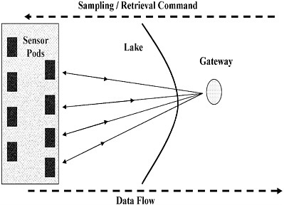
FIGURE 2-1 A schematic example of an embedded sensor network (ESN) in a lake environment. The shaded area indicates flexible networking connections between the pods with each other and the gateway. SOURCE: Seders et al. (2007). © 2007 by Mary Ann Liebert, Inc, publishers.
TABLE 2-1 Embedded Sensor Network (ESN)a
|
Embedded |
Networked |
Sensing |
|
Embed numerous distributed devices to monitor and interact with physical world |
Network devices to coordinate and perform higher-level tasks |
Tightly coupled to physical world |
|
Control system with, small form factor, wireless pods |
Exploit collaborative sensing take action |
Exploit spatially and temporally; dense, in-situ, sensing and actuation |
|
a Or ENS or sensor web. SOURCE: Adapted from http://research.cens.ucla.edu and http://sensorwaresystems.com. |
||
In a typical ESN, each pod is equipped not only with sensors but also with a radio transceiver, a small microcontroller that communicates with the pods, and an energy source—usually a battery and where feasible a solar cell; although the sensor pods may also be hard-wired for some applications.
The sensing devices in an ESN are ideally small, robust, and inexpensive, so that they can be produced and deployed in large numbers. In order to be field deployable at low cost, device energy requirements, memory, computational speed, and bandwidth (due at least in part to FCC regulations) are typically constrained.
A key desirable feature of ESNs is that they have the ability to self-organize in order to cope with changes. Data from the sensors are usually aggregated and analyzed, either by a computer within the network or outside it. That is, the pods in an ad-hoc wireless sensor network are effectively self-organizing and hence do not require detailed, pre-programmed knowledge of network topology in order to function. Such networks will also be robust to a certain degree of network modification and will continue to function as new nodes join the network or existing nodes fail or move to new physical locations. The ESN, with its unique global information-sharing protocol, forms a sophisticated sensing tapestry that can be draped over an environment. This approach allows for various complex behaviors and operations, such as real-time identification of anomalous or unexpected events, mapping vector fields from measured scalar values and interpreting them locally, and single-pod detection of critical events, which then triggers changes in the global behavior of the sensor network (Delin et al., 2005). Note that a pod in an ESN is merely a physical platform for a sensor and thus can be orbital or terrestrial, fixed or mobile, and often has real-time accessibility via the Internet. Pod-to-pod communication is both omni-directional and bi-directional where each pod sends out collected data to other pods in the network. As a result, on-the-fly data fusion, such as false positive identification and plume tracking, can occur within the ESN, and the system subsequently reacts as a coordinated, collective whole to the incoming data stream. An example of how an ESN can be used for real-time management and control of combined sewage outflow is provided in Box 2-1.
It should be noted that ESN accomplishments have been modest to date and that their potential significance is unresolved. However, their upside potential is so high that it will be important to attempt to resolve the many challenges that will present themselves for field deployment.
In summary, an ESN is a network of small, sensor nodes or pods communicating among themselves using radio communication, and deployed in large scale (from tens to thousands, creating a sensor “web” at high density) to sense the physical, chemical, and or biological world. Unique characteristics of an ESN are as listed below (Maurice and Harmon, 2007, and other manuscripts in Environmental Engineering Science special edition, March 2007). This list describes the optimum or ideal ESN that the scientific community can strive for, but it is
|
BOX 2-1 An Embedded Sensor Network for Control of Combined Sewage Overflow Events Many wastewater systems in the United States and abroad contain at least some components that were built to accept both sanitary wastewater and stormwater runoff, in order to minimize original construction costs. The problem with such systems is that during times of high flow, following storms or rapid snowmelt, the combined flow can become too great for sewage treatment facilities, and is then diverted directly into lakes and rivers, resulting in a combined sewage overflow (CSO) event. Following passage of the Clean Water Act in the early 1970s, municipalities were faced with a mandate to prevent such CSO events for the sake of the ecosystem and human health. Although many cities have invested millions to billions of dollars in updating their sewage systems, each year in the United States, CSO events still result in the release of hundreds of billions of gallons of untreated wastewater into lakes and rivers. In order to help municipalities to minimize CSO events, low-cost, embedded sensor networks are being developed specifically to address the CSO problem. Recently, Ruggaber et al. (2007) developed and deployed an embedded sensor network in South Bend, Indiana (USA). This system was designed to decrease the frequency and severity of CSO events by maximizing the existing storage capacity already present in the city’s combined sewer system. The embedded sensor network uses data gathered from a distributed network of sensors, many of which use wireless technologies, to provide decentralized, distributed, real-time control of the combined sewer system’s storage capacity using automated valves called Smart Valves (Ruggaber et al., 2007). By decentralizing the decisionmaking and control, each section of the sewage system is able to maximize its efficiency, providing a finer control mesh that minimizes flooding. The embedded sensor network controls the storage of stormwater runoff in a large retention basin using level data from sensors within the basin and at the combined sewage system outfall, which is several miles away. Before the embedded sensor network was in place, the basin often was ineffective, resulting in CSO events following even relatively small storms. After emplacement of the network, the basin has been able to store all of the water that enters during almost all storm events, preventing a CSO event into the local St. Joseph River. Once the threat of a CSO event decreases, the sensor network system automatically releases the water stored in the combined sewage system to prepare for the next storm. The real-time measurements within the combined sewage system can also be used to convert the existing CSO planning models into real-time control and operations models; to improve land management; to develop a real-time CSO public notification plan; to expedite maintenance; and to revise and improve the city’s |
|
overall CSO strategy (Ruggaber et al., 2007). This is thus an example of how an embedded sensor network can be integrated with municipal operations and public services to provide substantial environmental benefits at relatively low cost and with much faster and easier deployment than traditional technologies. Ultimately, individual municipal embedded sensor networks can be combined into a national network to provide protection to streams and lakes on a regional to national scale. |
likely that not all qualities will be attainable for all applications, given the many challenges of real-world environmental sensing.
-
Small-scale sensor nodes
-
Limited power requirements that they can harvest or store
-
Ability to use in harsh environmental conditions
-
Self-recognition of node failures
-
Adaptive monitoring, actuated sample collection
-
Potential real-time control of a local environment
-
Optimal management of power consumption related to sensor excitation and wireless data transmission
-
Potential mobility of nodes
-
Dynamic network topology
-
Self-recognition of communication failures
-
Heterogeneity of nodes
-
Large-scale deployment
-
Unattended operation
-
Web-based data and interaction (e.g., visualization)
The Need for New Sensor Probe Technologies
Fortunately, in concert with development of ESN technologies, sensors themselves are becoming increasingly smaller, more robust, and less expensive. In particular, physical sensors such as those that measure air and water temperature, water pressure, radiation, relative humidity, and wind speed and direction have evolved over decades and are now mass-produced and routinely packaged together in small instruments along with power and communication devices (Delin, 2002; Szewczyk et al., 2004; Vernon et al., 2003; Woodhouse and Hansen, 2003; Yao et al., 2003). These small and often inexpensive instruments often can be left in the field unattended for longer periods of time than traditional instruments, although problems of fouling, drift, etc. still need to be addressed. However, current physical sensor technology does not provide three-dimensional parametric physical information for air, water, soil, and groundwater over spatial scales ranging from the
micro-scale (e.g., pore volume) to the kilometer-scale, and integrating a web of sensors measuring at different scales (e.g., web pods with kilometer-scale satellite measurements) is poorly developed.
In contrast to hydrometeorological variables, sensor development for many important chemical and biological measurements is relatively immature (Estrin et al., 2003; NSF, 2005). For example, sensors that measure nutrients in soil and water (e.g., phosphorus, nitrate) remain relatively expensive and are subject to rapid fouling or degradation. Chemical sensors are needed to measure a wide range of elements and molecules for inorganic, organic, and biochemical molecules in all environmental media (atmosphere, soils, sediments, groundwater, and fresh and marine waters). In particular, reliable means for detecting toxins and determining the presence and amount of nitrogen and phosphorus forms are critically important. Biological sensor technologies in general are the least mature, but investments such as those described in the section below should result in tremendous scientific advances. Biological sensors can provide key information on the function and structure/composition of biologically influenced ecosystems in real time (NSF, 2005). Development of a wide range of field-robust chemical and biological sensors is one of the greatest challenges facing widespread deployment of sensor networks in the hydrologic sciences.
The characteristics needed by sensors within ESNs provide challenging design criteria: They need to be cheap enough to be widely disseminated, small, reliable, and robust. Specifically, they should have low power consumption (and/or use of renewable energy); be robust to temperature fluctuations; have low maintenance requirements; remain free of measure drift over the lifetime of deployment (or be able to self-calibrate or be capable of remote calibration); be resistant to deteriorating accuracy of measurements attributable to organic interaction with sensors (i.e., biofouling); and have environmentally benign components and operation. The sensor network itself has many requirements; it needs algorithms to help detect individual faulty sensors and to flag data accordingly, flexibility of platform location, intelligent and synergistic operation, methods to maintain data and physical security, and an ability to query sensors and possibly recalibrate them remotely. Thus, users have a long list of desirable sensor features, and such add-ons will tend to drive costs up.
NEW AND EMERGING BIOGEOCHEMICAL SENSOR APPROACHES AND TECHNOLOGIES
Over the past decades, a variety of new approaches have been developed for understanding and quantifying hydrobiogeochemical processes in the field. Some of these approaches have been well established and widely adopted; others are just emerging and may or may not live up to their initial promise to expand our observational abilities.
Biogeochemical field sampling began as a labor-intensive activity, requiring researchers to go to individual sites in the field and collect samples for field and laboratory experiments. In addition to being labor intensive, this sampling tended to be biased towards daytime sampling in good weather, that is, the summer field season. The development of automatic sampling devices such as the ISCO sampler, which could collect water samples over time in stored bottles for later retrieval, has proved helpful in expanding many studies, but this has numerous limitations, especially for parameters that need to be measured immediately. Data-sonde devices can be used for sampling surface and groundwaters and can be equipped with a variety of probes from temperature and dissolved oxygen to chlorophyll and nitrate. Although they have the ability to collect data continuously, they are expensive to equip and operate and the probes are subject to drift and fouling, which limit their usefulness. Nevertheless, together with automatic samplers, they have led to significant advances in hydrobiogeochemical understanding. A variety of sensors and field analytical devices relying on optical, ultraviolet, and infrared measurements have become available (McDonagh et al., 2008); connected to a range of sampling devices, they can be used to make multiple measurements, and can be integrated into projects depending upon cost and robustness requirements (e.g., temperature fluctuations).
Reviewing all of the new biogeochemical sensor technologies would be well beyond the scope of this report. Hence, in the sections below, the focus is on several examples of emerging technologies that may prove useful in hydrobiogeochemistry. First, a series of microsensor applications is presented followed by a discussion of molecular- to nanoscale sensors. Then applications of in-situ microcosms are introduced, followed by robotic samplers for biogeochemical monitoring. Later in this report (Chapter 4), some potential applications of the more developed of these technologies and approaches to existing hydrologic observatories are identified. As global observation systems are implemented, it will be essential to integrate the wide variety of different sensing approaches, in order to take advantage of the increased scientific capabilities and understanding.
Microsensors
Microsensors are miniaturized devices, micrometer to millimeter in size. They measure physical and chemical quantities such as pressure, acceleration, temperature, speed, and chemical or gas concentration. Typically they convert such physical or chemical quantities into an electrical signal, which, when calibrated, can be used as a proxy for the quantity itself. Below, three examples of microsensor applications to environmental problems are presented: (1) oxygen and pH sensors applied to acid-mine drainage, (2) nitrate sensors for biogeochemical
chemical applications, and (3) “lab-on-a-chip” designs for detecting pathogens in wastewater.
Microsensor Arrays for Biofilm Activity Associated with Acid-Mine Drainage
Mining activities expose rock surfaces to contact with air and water. Any sulfides present in such mine tailings, waste rock piles, or underground cavities can be oxidized under these conditions. Such oxidation reactions can lead to highly acidic conditions and elevated concentrations of dissolved metals such as iron, manganese, lead, cadmium, mercury, zinc, and copper. This highly acidic, metal-rich water can pollute streams and rivers and is a major environmental problem throughout the world, from the coal regions of Pennsylvania to the silver mines of Bolivia. Biogeochemical processes play an important role in controlling metal dynamics within acid-mine impacted streams. The reaction rates of acid-mine drainage reactions are accelerated many orders of magnitude by metal- (e.g., iron) and sulfur-oxidizing bacteria. As in other bacterial processes, bacteria adhere to surfaces in aqueous environments and excrete a slimy substance or biofilm that attach them to mineral surfaces. Recently, Haack and Warren (2003) used microelectrodes to probe in situ the dissolved oxygen and pH profiles within biofilms in an acid-mine drainage stream associated with a nickel mine in Ontario, Canada (Figure 2-2). Diel profiling with the microelectrodes demonstrated that biofilm oxygen and pH gradients varied both spatially and temporally, demonstrating that the biofilms are highly dynamic biogeochemical environments. By combining this in-situ microelectrode field analysis with sampling of metals and microorganisms, the authors demonstrated that hydrous metal oxide (HMO) minerals within the biofilm exert important influences on the concentrations of metals such as Ni, Co, and Cr, and that the HMOs themselves are effected by seasonal and diel processes. Combination of such high-resolution mechanistic information with more traditional field sampling and remote sensing can help to understand better the physical, chemical, and biological behavior of the acid-mine drainage sources, and to develop more-focused monitoring and remediation strategies.
Some of the remote sensing methods that could be combined with these new measurements include airborne thermal infrared and the airborne visible and infrared imaging spectrometer (AVIRIS). As the acid-mine drainage reactions are exothermic and generate warm water, airborne thermal infrared (TIR) can be applied to identify hidden sources of acid-mine drainage (Sams and Veloski, 2003) discharging into streams. The content of alkalinity-generating rocks within watersheds affected by acid-mine drainage determines the capacity of the streams to neutralize the acid. It is possible to identify and determine the areas covered by carbonate minerals such as calcite within the watershed using AVIRIS (Dalton et al., 2004).
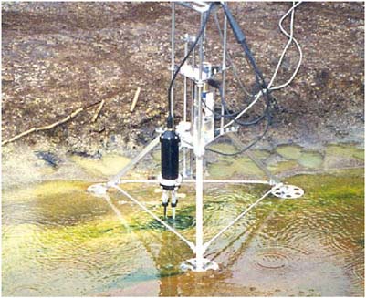
FIGURE 2-2 A microelectrode array probing pH and dissolved oxygen gradients in a biofilm associated with acid-mine drainage, Ontario, Canada. SOURCE: Reprinted, with permission, from L. Warren, McMaster University, Canada.
Scaleable Nitrate Microsensors in the Form of a Plant Root
Microfabrication processes are enabling the creation of mass producible sensors in form factors more attuned to the environmental media in which they are deployed. For example, flexible, miniature, and inexpensive nitrate sensors are being fabricated by electropolymerizing pyrrole onto carbon fiber substrates, using nitrate as a dopant (Bendikov et al., 2005). The resulting sensor (length 1 cm or less; diameter 7 to 10 um; Figure 2-3) is a size and shape that is ideal for deployment in the pore space of soils and sediments.
In addition, these highly selective electrodes require no excitation voltage and can quantify nitrate concentrations to just below 10−4 M (3 ppm). In-situ tests have revealed that prototypical microsensors of this type are short-lived in the environment, losing their sensitivity in a span of hours to days (depending on conditions), but can be reconditioned and redeployed within 12 hours. Research is underway on modified fabrication techniques and materials (Hatchett and Josowicz, 2008) as well as microfluidic strategies for sample pretreatment and may soon produce more robust microsensors for long-term deployments.
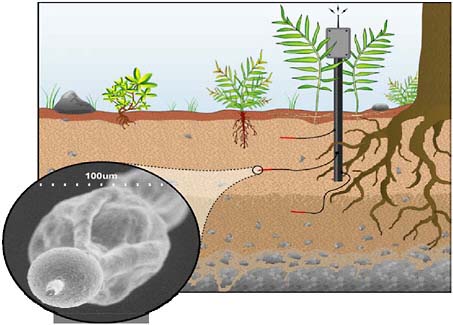
FIGURE 2-3 Illustration of an in-situ nitrate microsensor. SOURCE: Reprinted, with permission, from Jason Fisher, University of California, Merced.
“Lab-on-A-Chip” for Detecting Pathogens in Wastewater and Real-Time Process Control
Detection of pathogens in water samples is an important concern in environmental engineering, from protecting the water supply to managing wastewater. Ideally, one would like to have a small, cheap, efficient, and reliable detection system that could provide “real-time” data for management and control; i.e., a “lab on a chip” that could be tied to an ESN. The need to culture samples for analysis has made the identification of specific pathogens cumbersome and time consuming. Over the past decade, the development of molecular methods for evaluating microbial diversity and for detecting specific microorganisms without the need for cultivation has provided new hope for fast, easy, accurate, real-time monitoring.
Gilbride et al. (2006) review and evaluate recent progress in molecular microbiologic approaches, including discussion of microarray assays and of the state-of-the-art in the microfluidics and optoelectronics needed to realize sensor systems. They point out that one of the greatest impediments to development of detection systems for pathogens in wastewater and other environmental samples is the presence of numerous other compounds (organics, metals, etc.) that can
cause interferences throughout the process, from sample collection to DNA purification steps to amplification to signal detection and interpretation. Nonetheless, the authors conclude, “Albeit the limitations confronting lab-on-chip designs, they still hold much promise for real-time monitoring of wastewater effluent since rapid detection of pathogens from wastewater could reduce the risk of release into the environment.” It is important for the environmental community to keep track of advances occurring in the biomedical community, which has been intensely focused on development of microbial sensor systems.
Molecular- to Nanoscale Environmental Sensors
In recent years, the measurement of chemical parameters has turned to new technologies that consider the special properties present in structures of matter with at least one of the dimensions of the order of less than 100 nm or 10−7 m (e.g., Riu et al., 2006; Jianrong et al., 2004). The development of nanoscience and nanotechnology has opened the door for a new generation of “nanosensors” for various applications, including biomedical and environmental. For example, adsorption of a chemical species on the surface of bulk material is different from adsorption on the surface of a very thin film. The electrical properties of the film change. This change can be used to estimate the concentration of the adsorbed material, leading to development of new film-based sensors. Some other structures used as nanosensors include nanoparticles, nanotubes, nanowires, embedded nanostructures, and porous nanosensors (Riu et al., 2006). Application of such techniques to aqueous samples of environmental interest will depend upon development of prefiltration and potentially in some cases pre-concentration methods, and although the films tend to be very sensitive to individual chemical species, the potential for interferences from other components in an environmental sample will need to be addressed. Development of nanosensors for airborne materials, including contaminants, is in some cases less challenging and more progressed.
Nanosensor Types and How They Work
Due to their size, nanoparticles behave as quantum dots with wavelengths predicted by the wave-corpuscle duality principle. Particles with different sizes produce quantum dots with different wavelengths or energy levels. Nanoparticles (NPs) bound to biological molecules have been used in biosensors to detect and amplify an analyte. Carbon nanotubes (CNTs) are concentric cylinders a few nanometers in diameter. Length can be up to hundred of micrometers. They can be single-walled or multi-walled nanotubes. The electrical conductivity of
nanotubes changes when molecules of the analyte approach the walls of the nanotube. For example, the electrical conductivity of a single-walled nanotube changes in the presence of oxygen (Collins et al., 2000) as well as in the presence of other gases. Carbon nanotubes and nanoparticles can be functionalized with molecules to interact with specific analytes making them feasible for many possible applications.
Nanowires have been used to detect several chemical species, such as NO2 (Zhang et al., 2004). Boron-doped silicon nanowires (SiNWs) have been used to detect Ca2+ and pH (Cui et al., 2001). For pH, the SiNWs were functionalized with amine and oxide. The change of conductance with pH was linear and can be explained as a change in surface charge during protonation and deprotonation. Embedded nanostructures are nanosized microstructures within bulk solid materials, usually the microstructures are nanoparticles (Riu et al., 2006). They are like assemblies of nanoelectrodes. Nanosensors that use this method include a sensor for SO2.
Nanoporous polymer membranes have been used to construct low-cost humidity nanosensors (Yang et al., 2006). They can be fabricated with inexpensive materials such as polycarbonate, cellulose acetate, and nylon. Nanopore humidity sensors can detect the changes in resistance and/or capacitance due to water adsorption inside the nanopore cavities, which have a very large surface area. The porous membrane can sense the humidity because of ionic conduction. The adsorbed layer of water at the pore surface reduces the total sensor impedance as the ionic conductivity and the capacitance increase. Nanosensors to determine H+, Ca2+, K+, Na+, Mg2+, Zn2+, Cu2+, and Cl−, and other species have been constructed and encapsulated by biologically localized embedding (PEBBLEs; Buck et al., 2004). PEBBLEs are sub-micron-sized optical sensors designed to monitor an analyte concentration with minimum invasion and interference.
The development of nanosensors has occurred preferentially in the medical and biochemical field because of the need for real-time measurements of chemical and physical parameters with high resolution and negligible perturbation of the sample. These requirements also exist in environmental monitoring. One of the reasons for the preferential development in medicine and biochemistry is the ability to commercialize the sensor technologies for a large and potentially lucrative market. The environmental community needs to keep careful track of the biomedical community’s sensor developments and to seek out opportunities to expand nanosensor use to samples of environmental interest. Because the environmental community has significant strengths in areas such as surface chemistry and dealing with complex systems, it can offer the chemical and electrical engineering communities’ assistance with addressing issues such as biofouling, interferences, and surficial properties. The hydrologic community can work to offer expertise on the unique properties of water at surfaces and in nanopores/spaces.
Even when the different nanosensors are still in the development stage, they
should be pursued for environmental applications because they could offer several advantages with respect to conventional probes: (1) they should be smaller and more portable, (2) they should be cheaper, (3) when properly packaged, they could be more robust and keep better and for longer time calibration than macrosensors, and (4) they have low energy needs and therefore could be easily incorporated into ESNs run off of batteries. Funding should be available to develop nanosensors to their full capacity. The challenge will be to make the novel sensors robust enough for field deployment and to calibrate and verify them against existing macroscale and laboratory analysis, where applicable.
An Example of Bacterial Surface Force Measurements
One example of the use of nanoscale technologies for environmental sensing is the use of the atomic force microscope (AFM) to conduct force measurements between the surfaces of bacteria and other surfaces of biogeochemical interest, such as minerals, organic films, and other bacteria (Figure 2-4). The AFM is formed by a microscale cantilever with a sharp tip or probe at its end. This tip is used to scan the specimen surface. When the tip is brought into proximity of a sample surface, forces between the tip and the sample deflect the cantilever. The deflection is measured using a laser spot reflected from the top of the cantilever and detected by an array of photodiodes. Microcantilevers are discussed in detail in Goeders et al. (2008).
For example, Lower et al. (2001) used the AFM to measure the forces between a dissimilatory metal-reducing bacterium, Shewanella oneidensis and the Fe oxyhydroxide mineral goethite. Force measurements were made with subnano-newton resolution in real time using living cells in aerobic and anaerobic solutions, as a function of the distance between the cell and the mineral surface, in nanometers. In another example, Lower et al. (2005) used AFM to measure the forces between a protein on the surface of living Escherichia coli bacterium and a solid substrate, in situ. Understanding the forces between environmental surfaces can help in developing models for a host of environmental processes ranging from how bacteria attach to minerals and form biofilms to the factors controlling retardation of pollutants in subsurface environments.
At the current time, the AFM is primarily a laboratory instrument, although AFMs can be taken into the field for use in mobile labs. AFMs have been manufactured to fit in the palm of one’s hand or in a pocket, and to require very little power to operate. Hence, AFMs are even being considered for inclusion in manned missions to Mars (http://www.nasa.gov/missions/science/afmicroscope.html). Application of these and other nanoscale sensors to aquatic and terrestrial field sites will be challenging given concerns about sensor operation and life-time time (e.g., Buffle and Horvai, 2000), including biofouling, calibration drift, need for prefiltration, interferences, and other factors.
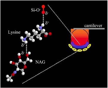
FIGURE 2-4 An AFM cantilever coated with bacteria attached to the probe using an organic “glue” for use in nanoscale force measurements. SOURCE: Reprinted, with permission, from Steven Lower, Ohio State University.
In-Situ Microcosms: Combining Field Experiments with Microbiologic and Surface Science Techniques
Although ESNs with real-time data acquisition and transmission promise to revolutionize biogeochemical research in the hydrologic sciences, many biogeochemical processes, such as mineral weathering, occur slowly and can benefit from other in-situ measurement techniques. The in-situ microcosm approach in biogeochemistry, wherein mineral surfaces are placed in “holey” containers in the field and excavated months to years afterwards for analysis by sophisticated surface science and microbiologic techniques, has proven highly useful for understanding mineral weathering rates and mechanisms (e.g., Bennett et al., 1996; Nugent et al., 1998; Maurice et al., 2002). Fundamental hydrobiogeochemical questions raised by more traditional sampling approaches can be explored mechanistically by use of these in-situ reactors that act as sampling devices at timescales appropriate for the processes in question, resulting in data integrated over an appropriate timescale.
Nugent et al. (1998) used an in-situ microcosm approach to investigate rates and mechanisms whereby feldspars, which are the most abundant minerals at the
Earth’s surface, weather in an acidic soil. This research was conducted to address why many previous experiments had tended to suggest different rates and mechanisms of feldspar weathering in the laboratory versus the field. The albite feldspar surfaces were buried for up to several years, and analyzed by auger electron spectroscopy, X-ray photoelectron spectroscopy (XPS), and secondary ion mass spectrometry for surface composition and depth profiling, and by scanning electron microscopy and atomic force microscopy for particle micromorphology and microtopography. The results suggested that previously observed apparent differences in field versus laboratory rates of weathering could result at least in part by formation of a thick natural mineral coating on the feldspar surfaces that could not be detected by more conventional methods.
In another study, Maurice et al. (2002) used in-situ microcosms as an independent method to determine whether mineral weathering rates in the hyporheic zone (i.e., the wetted sediments surrounding a stream; Figure 2-5) of an Antarctic Dry Valley stream were as fast as indicated by stream chemistry measurements; the fast weathering rates appeared to be at odds with the fact that mineral weathering rates are thought to be slow at low temperature and in the absence of vascular plants. Mica chips were buried in in-situ microcosms in the hyporheic zone of Green Creek, a McMurdo Dry Valley stream for 39 days of the short Antarctic “summer”.
AFMS and XPS revealed that the mica surfaces were quickly colonized by bacteria (Figure 2-6) and that small etch pits formed indicating a relatively fast weathering rate. Analysis of soil bacteria indicated a rich microbial community including nitrate-reducing bacteria. Overall, this study indicated the importance of combining different approaches, from traditional hydrologic and water chemistry analysis to microbiologic analysis, to application of surface science techniques, to help understand rates and mechanisms of biogeochemical processes.
The in-situ microcosm approach is being further expanded to include flow-through systems for investigating stream hydrobiogeochemical processes involving microorganisms. Microbial communities are often highly complex, and their biogeochemical behaviors are best studied in the field. This is because microbial communities and their biogeochemical behaviors are essentially impossible to maintain in the laboratory. Professor Gill Geesey and graduate student Eric Boyd at Montana State University have developed in-situ continuous-flow reactors (Figure 2-6) that can be emplaced in field sites and allowed to incubate for extended periods of time. The researchers have used these in-situ continuous flow reactors, coupled with geochemical and molecular microbial analysis, to investigate directly carbon fixation by sulfur-associated microbial populations in an acid geothermal spring in Yellowstone National Park (G. Geesey, Montana State University, pers. commun., October 2006). By using such an in-situ method,
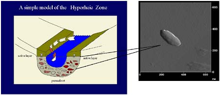
FIGURE 2-5 Left: A schematic of the hyporheic zone of an Antarctic Dry Valley stream. The lower boundary of the hyporheic zone is well-defined by the permafrost. SOURCE: Reprinted, with permission, from Diane McKnight, University of Colorado. Right: An atomic force microscopy image of a bacterium on the surface of a mica particle buried in the hyporheic zone. SOURCE: Reprinted, with permission, from Maurice et al. (2002). © 2002 by Elsevier.

FIGURE 2-6 In-situ continuous flow reactors for microbiologic community and activity sampling. SOURCE: Reprinted, with permission, from E. Boyd and G. Geesey, Montana State University.
the microbial community composition and physiological activity can be determined in the field, thus helping to ensure that the results are indicative of actual field processes.
Arsenic in drinking water can pose a serious human health risk; arsenic has been linked to a variety of different types of cancer, to serious skin conditions, and to nervous system damage. Professor Janet Hering at the Swiss Federal Institute of Aquatic Science and Technology (Eawag) has been leading a study to determine the controls on arsenic mobility in the Los Angeles Aqueduct system (e.g., Kneebone and Hering, 2000). An important component of this research is determining the concentration and mobility of arsenic in pore waters of surficial sediments in the aqueduct management system. This can be challenging because arsenic speciation can be disturbed by traditional sampling methods. Her group has used a gel probe sampler composed of polyacrylamide gel slabs held in a Plexiglas ladder, which is placed in the sediment and allowed to equilibrate with the pore water for several hours. The sampler is then removed and the pore water is analyzed in the laboratory. Recently, Hering and her associates have modified the sampler by doping the gel slabs with Fe(III) oxyhydroxide to provide further information on arsenic adsorption to reactive mineral surfaces (Root et al., 2005). Like the in-situ microcosms describe above, this novel sampler provides data from a given field site at a sampling time/period appropriate for the hydrobiogeochemical processes of interest and in a manner that merges field and laboratory methods to provide high-quality analysis of in-situ field conditions.
Robotic Samplers for Aquatic and Terrestrial Biogeochemical Monitoring
As described above, ESNs are expanding opportunities in high-resolution, real-time environmental monitoring and control. In many instances, such as for investigating spatially and temporally variable biogeochemical processes in lakes and in the marine environment, it may be beneficial to have mobile sensor platforms or pods integrated into the sensor network. Ongoing research by G. Sukhatme and colleagues (Sukhatme et al., 2007; Dhariwal et al., 2006) focuses on development and test deployment of a mobile robotic boat operated in conjunction with a static network of buoy nodes (Figure 2-7). The static buoys provide “low-resolution spatial sampling with high temporal resolution while a mobile robotic boat provides high resolution spatial sampling with low temporal resolution” (Dhariwal et al. 2006). The robotic boat performs autonomous global positioning system (GPS) way-point navigation between the static nodes, collecting biogeochemical data along the pathways. Sensors used in test deployment include thermistors, along with fluorometers to measure the concentration of chlorophyll-a, which is a key indicator of the presence and activity of
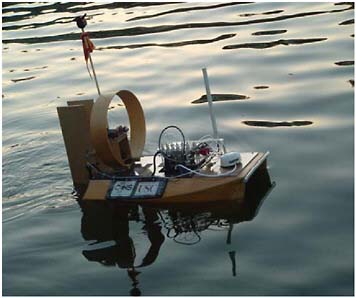
FIGURE 2-7 A robotic boat for microbiologic sampling. SOURCE: Reprinted, with permission, from Dhariwal et al. (2006). © 2006 by IEEE.
certain photosynthetic microorganisms. The combination of static buoys and a robotic mobile sensor unit represents an intriguing advancement in real-time measurement of environmental parameters in aquatic environments and furthers the possibility for sensor-actuated sampling to provide excellent coverage both spatially and temporally.
In another application, Harmon et al. (2007) have developed a rapidly deployable networked infomechanical system (NIMS RD) technology for measuring hydraulic and chemical parameters across stream channels. The system consists of two supporting towers and a suspension cable that delivers both power and Internet connectivity to control and actuate a tram-line NIMS unit, which raises and lowers a sensor pod either according to a pre-programmed route or a data-actuated adaptive scan. This tram-like robotic device has been test deployed in a small urban stream in Southern California and the San Joaquin River in Central California, and has been used for both nutrient (nitrate and ammonium sensors) and salinity sampling, in addition to temperature and pH. Because the system is rapidly deployable, it could potentially be moved around a geographical area to monitor sudden events such as combined sewage overflow to rivers.
Hamilton et al. (2007) developed a NIMS tram system as part of a terrestrial ecological observatory at the University of California James San Jacinto Moun-
tains Reserve. The NIMS tram system (Figure 2-8) was designed to integrate with fixed sensors (soil sensors for CO2, NO3, H2O, temperature, soil moisture content along with soil microrhizotron) to help support modeling of soil biological activity and CO2 flux. The mobile robotic NIMS unit is mounted to a cable and uses an IR thermal scanner system to map the soil surface temperature, along with above-ground profiling of wind, incident solar radiation, and relative humidity above each of the fixed soil sensor nodes. In addition, a three-dimensional laser scanner is used to build a model of the tree and shrub canopies to collect data for modeling of solar interception and to produce volumetric biomass measurements. This network of fixed and mobile sensors is providing continuous measurements of microclimate and soil data at a spatiotemporal resolution that our understanding of forest dynamics into global carbon models (Hamilton et al., 2007).
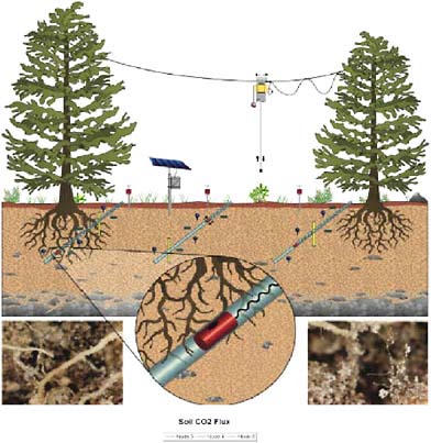
FIGURE 2-8 A NIMS tram for microclimate measurements, coupled with soil measurement techniques. SOURCE: Reprinted, with permission, from Hamilton et al. (2007). © 2007 by Mary Ann Liebert, Inc.
Interdisciplinary Challenges
As discussed above, all of the novel and emerging approaches described above share the common trait of requiring interdisciplinary cooperation and collaboration, not only within the scientific and engineering communities, but also sometimes with other communities, regulators and managers, and corporations. Within academia and many government research organizations, grants for research funding are obtained based on novel research ideas and significant new advances, with less funding available for continued development. Dissertations in electrical and chemical engineering can be built on development of a novel environmental sensor, but the field testing and implementation are ultimately the realm of the environmental scientist/engineer.
For novel sensors to become available at low cost and in abundance, they will need, in most cases, to be turned over from scientific researchers to the private sector, which means that they have to be commercially viable. For example, hydrobiogeochemical sensors that are useful not only for research but also for municipal and domestic water use increase the commercial viability and the probability that corporations will work harder to develop, test, and commercialize the sensors. In another example, computer scientists and engineers can write dissertations on optimizing codes for ESNs, including detecting faulty data, and new data management schemes and for novel computational methods. But, a dissertation only lasts a few years until the project is passed to the environmental scientists for long-term use and management, along with potential further code development.
Importantly, a significant market presence can encourage creation and acceptance of industry standards for sensor compatibility, communication, and sensor metadata. For instance, standardized approaches that automate capture and encoding of sensor metadata can facilitate the process whereby sensor data are ingested, quality assured, transformed, analyzed, and converted into publishable information products (Michener, 2006). Automatic metadata encoding should also enable scientists to track data provenance throughout data processing, analysis, and subsequent integration with other data products.
The hydrologic community has a good deal to offer electrical and chemical engineers, computer scientists, and other researchers working on sensors and sensor systems by providing new types of applications, experience with complex systems, detailed knowledge of water properties and flow, and specific expertise with a variety of Earth materials. Ultimately, in order for many of the emerging sensing approaches to succeed, it is important for agencies and foundations to facilitate collaboration between researchers in different fields, not only through short-term initiatives but also in the long term, and to assist scientists and engineers in building successful partnerships with corporations and communities.
AIRBORNE SENSORS
Airborne hydrologic sensing systems are potentially powerful, but infrequently used, elements of comprehensive hydrologic observing systems. While airborne systems are commonly used for high-resolution topography, land-use/land cover classification and change, and other purposes, they are infrequently used by hydrologists designing observing systems. This is because they tend to be expensive relative to in-situ sensors, the time required to develop a competent airborne system when one is not readily available is often long relative to the time available for the anticipated field project, and lack of access to competent airborne systems has limited development of the interpretive models needed to fully use airborne data.
However, there are several hydrologic applications that are common enough to have been taken up by the private sector. For example, high-resolution TIR imagery can be used for water temperature monitoring. Applications include characterizing point source thermal pollution, mapping aquatic habitat for threatened and endangered fish, and identifying groundwater discharge zones (including acid-mine drainage sites; see earlier section on “Microsensor Arrays for Biofilm Activity Associated with Acid-Mine Drainage”). For applications with high spatial- and spectral- resolution requirements, the Airborne Imaging Spectroradiometer for Applications (AISA) sensor system is commonly used. L-band passive microwave instruments also have shown their value in soil moisture mapping (see section on Spaceborne Sensors).
Interferometric synthetic aperture radar (InSAR), which measures elevation changes of the ground surface, has shown considerable promise for a number of water-related applications. These include timing, magnitudes, and patterns of seasonal ground movement in response to groundwater pumping and artificial recharge, estimating the elastic storage coefficient of an aquifer system (in conjunction with in-situ water table observations), and as a constraint for inverse modeling of regional groundwater flow (Alley et al., 2002).
The value and potential of airborne sensors are best understood by distinguishing among the distinct purposes for such systems. Airborne hydrologic sensing systems are developed to serve in one or more of three categories:
-
As an operational system to extend observations beyond the spatial domain of point measurements or to fill the gap between plot-scale observations and satellite-scale observations,
-
As a simulator of a satellite instrument to calibrate and/or validate data from a current or future satellite observing system, and
-
As a research instrument to support investigations of hydrologic processes where physical access to the spatial domain of a process is limited or where providing an adequate density of point measurements to characterize a process would be impractical.
Operational federal agencies, like NOAA and the USGS, or state agencies charged with water resources management, are likely to sponsor systems in Category 1. An airborne gamma ray system to measure Snow Water Equivalent (SWE) is an example of a Category (1) system. The National Weather Service routinely offers gamma flights to supplement the 1700 point measurements of SWE at snow pillows and transects of calibrated snow courses using airborne gamma ray sensors (e.g., Duval, 1977). However, data must be corrected for soil moisture. Gamma flight lines do not provide complete watershed coverage, but do provide much better spatial coverage than do the ground-based measurements. In “Achieving Predictive Capabilities in Arctic Land-Surface Hydrology” (Chapter 4), the role of airborne sensors as an integral part of an observing system is described. For example, airborne gamma ray, typically operated by contractors, is an operational element of regional water storage management systems for the northern prairie (Fritzsche and Burson, 1973).
Airborne data collection might also be used to help design terrestrial- or aquatic-based sensor networks or sensor webs. Where this is appropriate, they would be similarly useful in helping to oversee, calibrate, and integrate a sensor network once it has been established. Airborne systems can also be invaluable for scaling between sensor networks and satellite-based observations.
Until recently1, the National Aeronautics and Space Administration (NASA) has had primary responsibility for developing satellite environmental sensing technologies. In that role, NASA produced several Category 2 airborne hydrologic sensors. Examples include the Electronically Scanned Thinned Array Radiometer (ESTAR; Levine et al., 1990), the Airborne C-band Microwave Radiometer (ACMR; Kim et al., 2000), and the Passive and Active L and S band (PALS; Wilson et al., 2001) microwave instrument. While none of these were ever to be exact simulators of future satellite sensors, each incorporates essential aspects of an anticipated satellite sensor. Because NASA focused primarily upon Category 2 objectives, developing global environmental observing technologies, and not Category 3 objectives, addressing research opportunities in hydrology, the airborne platforms chosen to carry NASA’s sensors were either large, long-range aircraft capable of deployment to any spot on the globe, or aircraft capable of flying in the stratosphere above the 16 km altitude limit of most commercial aircraft. These NASA aircraft have been expensive to operate, difficult to operate safely at speeds below 90 m/s or at altitudes below 300 m above ground level, and unable to operate out of small airports or unimproved fields. Some consequences of this selection of platforms have been that the cost of using NASA’s airborne hydrologic sensors have prohibited near-daily use in season-long field campaigns, or deployment to smaller campaigns in difficult locations, e.g., they have never been used in Arctic land-surface hydrology. Where they have been used, the difficulty of safely flying low and slow has
meant that the data from these systems have often to satellite-scale gap in spatial-resolution of low spatial resolution sensors like microwave radiometers.
NASA’s Category 2 airborne systems have been used in a Category 3 capacity, that is, to examine hydrologic processes that extend beyond the spatial domain of point measurements. While not ideal for this role, there are few other systems available for Category 3 purposes. As inaccessible as NASA airborne systems have been relative to the need, they have become even less accessible with NASA’s change in focus away from the Earth sciences.
Category 3 airborne systems, those used in support of research, typically employ airborne platforms that are less expensive and have capabilities that are optimized for the objectives of the research. Examples of this include sensors on light commercial and homebuilt aircraft (e.g., Baldocchi et al., 1996), ultralight aircraft (e.g., Junkermann, 2000), helicopters (e.g., Hyyppa and Hallikainen, 1993), remotely controlled blimps (Inoue et al., 2000), and unpiloted airborne vehicles (UAVs) (e.g., Schoenung and Wegener, 1999). These systems contribute greatly to advancing our research by enabling observations at spatial and temporal scales that are otherwise inaccessible and because they are typically under the direct control of the science investigators. They are also challenging to develop and maintain. Airborne sensor systems are expensive relative to in-situ systems, their development typically requires several years before the data they produce are reliable, and effective interpretation of data from new airborne sensors often requires development programs that can be unique to the proposed application.
Table 2-2 offers an approximate comparison of operating costs. These costs do not reflect the time to develop the sensor, integrate it with the airborne platform, or successfully complete the test, “make-work”, and system validation phase of development. Of these, the test, “make-work”, and system validation phase is often underappreciated and under-funded. Care should be taken to reserve sufficient funds for this phase of development so that airborne systems do not arrive in the field before they are ready to produce reliable and interpretable data.
The difficulty and experience required to develop competent airborne systems favor establishing frequently reviewed centers having this competence. The airborne platforms often have to be modified with holes for sensors, with enhanced electrical systems that are free of electrical noise, and with command and data systems that guide surveys of pre-determined flight lines and recover observed and instrument performance data that can be co-located with position, attitude, and environmental data. The instrument itself often must be designed to be smaller, lighter, and/or consume less power than previous examples of similar instruments. They often need to function in a hostile environment that includes vibration, large excursions in temperature and pressure, noisy power sources, and typically constrained opportunities for calibration. Centers like the
TABLE 2-2 Examples of Airborne Platforms Capable of Carrying the Canonical Hydrology Sensing Instrument (for general comparative purposes only; cost estimates in 2007 dollars)
|
Class Aircraft |
Sourcea |
Example |
Payloadb |
Approx. Cost/Flight Hrc |
Daily Rate (Labor)d |
|
Fixed-Wing, single piston engine |
Commercial utility, new |
Aviat Husky A-1B |
300 lb/135 kg |
$200 |
$500 |
|
|
Homebuilt utility, new |
Zenith CH 801 |
450 lb/200 kg |
$200 |
$500 |
|
Fixed-wing – single turboprop engine |
Commercial utility, used |
Fairchild/Pilatus Porter |
1500 lb/680 kg |
$1,500-$2,000 |
$1,000 |
|
Fixed-wing - twin turboprop engines |
Commercial utility, used |
DeHavilland Twin Otter |
1500 lb/680 kg |
$750 |
$1,500 |
|
Helicopter, single turbine engine |
Commercial utility, used |
|
1000 lb/450 kg |
2,000 |
$1,500 |
|
UAV, single piston engine |
Commercial utility, new |
Predator |
300 lb/135 kg |
About $1 million/month (~$30,000-40,000/day) |
|
|
UAV, single piston engine |
Commercial utility, new |
Aerosonde |
11 lb/5 kg |
$1,000-$1,500 |
$4,000-$10,000 |
|
Fixed-wing, 4 turboprop engines |
Commercial utility, used |
Lockheed C-130 |
20,000 lb/9,100 kg |
~$10,000 |
$2,000 |
|
aThe choice of new or used aircraft is based upon the likelihood of finding one in suitable condition. The ratio of flight time to ground preparation time for aircraft used in research is typically very low relative to other uses of aircraft. A few hundred hours of flying time per year might be the norm. This level of utilization does not require a low-time airframe or engine, but the research application does require high reliability and safety, which translates to a requirement that the aircraft be in excellent condition. Single engine, piston utility, and homebuilt aircraft have a higher likelihood of fatigue or hidden problems than the other categories of aircraft. For these aircraft, project risk is reduced with new aircraft. bPayload is payload listed for aircraft in a typical configuration less the weight of required crew and the weight of fuel in main fuel tanks. cApproximate cost per operational hour. This does not include amortization of the platform or instrument, nor does it include the cost of the special support crew necessary to maintain and operate the aircraft during a field campaign where the aircraft is not at its normal home base. These costs are major cost drivers depending on the aircraft, and can range from a low of one person in the field who supports the instrument, does aircraft maintenance, and flies the plane, to as high as 20 personnel that are required to support the Predator. All other aircraft fall in between. A rule of thumb, except for UAV systems as the Predator, is the number of support personnel required to go into the field equals the number of engines on the aircraft. The flight hour costs posted in the above table cover primarily the direct operating costs of the aircraft. It is assumed that a member or members of the science team are qualified to pilot the fixed-wing, single-piston engine, aircraft such as the Aviat Husky or the Zenith CH 801. If the pilot is not qualified, then additional daily costs for the pilot would apply. Despite these costs, it is generally recommended to lease these services rather than purchase an aircraft. dAssumes about $500/person, which includes salary and travel. SOURCES: G. W. Postell and A. R. Guillory, Wallops Flight Facility, NASA; A. W. England, University of Michigan. |
|||||
NOAA airborne facility at Boulder, Colorado, and a few university laboratories do provide high-quality airborne instruments. Maintaining these competencies should be a concern of the hydrologic community and the federal funding agencies.
Comprehensive descriptions of all potential airborne platforms would fill volumes. The span of platforms appropriate for hydrologic research can be greatly reduced by characterizing a reference sensor or set of reference sensors that a subset of airborne platforms might accommodate. One reference sensor might be an airborne SWE profiler that employs nadir-viewing, 1.4, 6.9, 19, and 37 GHz radiometers. Using the best of today’s technologies, such a system might weigh 100 kg, consume 200 W, require external antennas with a combined aperture of 1 m2 and a thickness of 10 cm, occupy a volume inside the aircraft of 30 cm3, and cost less than $150/flight hour to operate not including the cost of the pilot, amortization of the system, or the cost of the radiometer system. It would fly safely during daylight hours at altitudes above ground level of between 30 m and 1 km, at speeds as slow as 30 m/s, and have the endurance to cover 500 km without refueling. Of the potential airborne platforms, only commercial and homebuilt light, fixed-wing aircraft and UAVs might have this performance envelope. Table 2-2 offers examples of suitable platforms along with examples of platforms that might be suitable for other reference sensors. The C-130, a four-engine turboprop aircraft used by NASA, is included in Table 2-2 for purposes of comparing operating costs. It is shown in Figure 2-9.
Homebuilt aircraft kits are listed, because they often possess characteristics that are of value in Category 3 research projects. Homebuilt aircraft kits tend to be small, relatively inexpensive to purchase, simple to fabricate, and inexpensive to maintain, because the builder is legally allowed to perform required maintenance. Because the builder is responsible for the structural integrity of the aircraft, they are relatively simple for a team with access to aircraft design talent, as would be the case with most engineering colleges, to add an instrument pod or to pierce the aircraft skin for instrument cables. These characteristics have been successfully used for research purposes (Oechel et al., 2000). If conservative designs using proven aircraft-quality engines from kit manufacturers having a history of, perhaps, hundreds of successful fabrications are chosen, there is little physical risk beyond the normal risk of operating light aircraft safely.
UAVs capture attention for their potential of avoiding the risk and expense of protecting pilots from challenging environments, e.g., altitudes above 16 km, and to enable use of smaller platforms that need not accommodate a pilot. UAVs are expensive to develop and can be expensive to operate if their support systems are complex. They have been developed primarily by the Department of Defense to avoid placing pilots in hostile battle environments, to enable observing systems that are small enough to be difficult to detect, and, where the
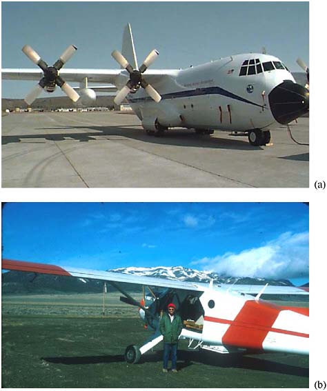
FIGURE 2-9 High-end and low-end airborne sensing. (a) A Lockheed C-130 airplane, extensively modified by NASA for use as a research platform and supporting a wide variety of onboard sensors, including multispectral scanners, radiometers, air sampling equipment, and aerial cameras. SOURCE: Available online (b) A de Havilland Canada Beaver configured for airborne geophysics in the 1970s. The primary instrument was a 1.4 GHz profiling radiometer. SOURCE: Photos courtesy of Gordon Johnson, U.S. Geological Survey.
objective is simply imaging, to enable the use of simple systems, like the Predator in Table 2-2, in a battlefield environment without complex support systems. If there were a UAV system that met the requirements of our reference sensor, its size and support requirements would approach those of a small, piloted aircraft, and, because of its newness, operation in populated areas would present safety issues for the air traffic control system and for people on the ground.
There are significant advantages in research effectiveness to attaching research aircraft to the facilities that build and operate the research instruments. This is a characteristic of the highly successful NOAA airborne operation in Boulder, Colorado. Universities often serve as operators of the simpler of these aircraft, but they typically lack sufficient volume of instrument building and community demand for field use of their instruments to justify dedicated aircraft at the more complex and expensive end of the platform spectrum. One comprehensive Category 3 research program, like the NOAA operation, and several university programs that focus upon new instrument technologies utilizing the less complex airborne platforms might serve as an optimum combination to support hydrologic research.
SPACEBORNE SENSORS
Satellite remote sensing plays a critical role in establishing a framework for integrating hydrologic and environmental observations over space and time. Spaceborne sensors offer an unparalleled, synoptic view of the landscape, providing a natural template for upscaling and extrapolating traditional hydrobiogeochemical measurements, in-situ sensor network, and airborne measurements. On the other hand, the direct terrestrial or aquatic and airborne measurements can serve to “ground-truth” satellite remotely sensed data and to provide additional data that cannot be remotely sensed, such as information on details of biochemical reactions in soils or microbial community analysis. Routine collection of satellite data allows for monitoring the dynamics of natural systems in space and time, while the space-based, global view enables interpretation in the context of larger-scale Earth system processes. Moreover, satellite platforms can serve as pods in embedded networks (i.e., as spatially distributed sensor platforms that wirelessly communicate with each other), providing real time information on the state of the observed system, or prediction of future states, that could trigger adaptive behavior of the sensor web. Satellite measurements are sometimes the only measurements available in locations that are remote or inaccessible for political reasons. As such, spaceborne measurements are a key element in data assimilation or any other viable scheme for integrating observations.
In order to realize the full potential of satellite remote sensing for enhancing
integration strategies, its current limitations must be well understood in order to focus research priorities. Here three critical areas for research—rather than an exhaustive list—are described as examples of the significant challenges that lie ahead for remote sensing of hydrologic and related parameters. These areas include the impact of heterogeneity on enhanced retrieval algorithms, enhanced antenna engineering, and the role of geodetic satellites in hydrology. The focus here is limited to liquid water and snow. Although the dynamics and mass balances of glaciers and ice sheets are well monitored by satellite (e.g., Rignot and Thomas, 2002; Velicogna and Wahr, 2006a,b), a full assessment of the role of cryospheric remote sensing in integrated hydrologic observations is beyond the scope of this particular study.
Microwave emissions from the land surface have a strong sensitivity to several hydrologic variables, including soil and snow water content, as well as other land-surface characteristics such as vegetation water content, soil texture, and surface roughness (e.g., Jackson et al. 1999). As such, the development of inversion algorithms for the production of minimally biased estimates of the variable of interest, e.g., soil moisture, from passive and active microwave measurements, has proven challenging. Stated more simply, the variable of interest (such as soil moisture) is not directly observed by the sensor (a problem endemic to many types of environmental sensors) and has to be indirectly estimated using ancillary data. The inversion problem is further complicated by the need to account in algorithm development for the tremendous heterogeneity of land surface within a sensor footprint. Hence, there is a pressing need for focused efforts to develop enhanced algorithms that account for the scaling of relevant heterogeneous variables within satellite footprints to best understand the relationship between observables and derived hydrological products. The integration of different types of data—traditional measurements such as grab samples, in-situ sensor network data, and airborne data—will help in the development, verification, and validation of these algorithms. The problems posed by land-surface heterogeneity underscore the need for terrestrial observatories for hydrologic and related environmental sciences; it is the integration of in-situ aircraft and satellite observations that will ultimately yield significant advances in understanding Earth processes, while also advancing individual sub-disciplines.
Considerable engineering challenges also pose obstacles to advancing space-based hydrological observation. For example, remote sensing of the moisture content of surface soils has been most successful using passive microwave instruments. The capability currently exists to retrieve surface (0-2 cm) soil moisture estimates from the space-based Advanced Microwave Scanning Radiometer-EOS (AMSR-E) instrument at frequencies of about 6 GHz (C band) (Njoku et al., 2003). However, previous research has shown that frequencies in the 1 to 3 GHz (L band) range are better suited for soil moisture retrievals because the microwave emissions emanate from within a deeper soil layer (0-5 cm) (e.g., Jackson et al.,
1995, 1999). Moreover, since biosphere-atmosphere moisture exchanges are influenced by the soil moisture within the entire vegetation root zone, the ability to remotely monitor soil water within the deeper soil profile would be a major advance in Earth observation science. The inherent spatial resolution of AMSR-E soil moisture data is 60 km, yet higher resolution (e.g., 10 km) is optimal for hydrometeorological application. The spatial resolution of microwave data is controlled by antenna size: wider antennas yield higher spatial resolutions. For example, a spaceborne L-band passive microwave instrument would require a 6-meter wide antenna to deliver soil moisture at 40-km spatial resolution. While land-based systems such as ground-penetrating radar offer promise for monitoring deeper soil water content, and airborne L-band passive microwave instruments have proven soil moisture mapping capabilities (Wang et al., 1989; Jackson et al., 1995, 1999, 2002), innovative sensor design and antenna technologies are required before the success of ground and aircraft systems can be achieved in space.
A third avenue for pursuing major advances in hydrologic remote sensing is space geodetic remote sensing. Water cycle observations derived from satellite altimetry (e.g., TOPEX/Jason) and from space-based measurements of Earth’s time variable gravity field (e.g., the Gravity Recovery and Climate Experiment, GRACE) provide opportunities to observe terrestrial hydrology in new and informative ways (Alsdorf and Lettenmaier, 2003; Famiglietti, 2004; Lettenmaier and Famiglietti, 2006). Birkett (1995, 1998), Birkett et al. (2002), and Alsdorf et al. (2001) have demonstrated that satellite altimetry can successfully monitor surface-water heights from rivers, lakes, and floodplains. Satellite altimetry missions such as TOPEX/Poseidon and Jason, which are optimized for ocean applications, have great promise for monitoring the elevation and storage changes of inland water bodies, but unless future altimetry missions (Alsdorf et al., 2007) give greater consideration to continental freshwater targets, their utility in hydrology will be limited. The GRACE mission (Tapley et al., 2004) is now providing estimates of total (combined snow, surface water, soil moisture, and groundwater) water storage variations from the large basin to continental scales and providing new insights into the hydroclimatology of terrestrial water storage. When combined with ancillary data, GRACE can also be used to estimate evapotranspiration (Rodell et al., 2004; Ramillien et al., 2005; Swenson and Wahr, 2006) and discharge (Syed et al., 2005) for large (200,000 km2) river basin systems. While interferometric synthetic aperture radar (InSAR) has been shown to successfully monitor ground deformation resulting from groundwater recharge and discharge (Bawden et al., 2001), the GRACE mission may provide the only viable means for quantifying groundwater storage changes using remote sensing (Rodell et al., 2006; Yeh et al., 2006). An InSAR mission has been proposed by the Decadal Survey (NRC, 2007) for applications such as glacier velocity and surface elevation. With such new opportunities for hydrologic obser-
vation comes the challenge to the hydrologic community to embrace these non-traditional data types and to incorporate them into modeling and analysis studies. The need for such methods is highlighted in Chapter 4, for example in “Impacts of Agriculture on Water Resources: Tradeoffs between Water Quantity and Quality in the Southern High Plains,” and “Hydrological Observations Networks for Multidisciplinary Analysis: Water and Malaria in Sub-Saharan Africa,” where there is a great need for integrative data at large spatial scales or in remote locations.
Beyond the three challenges describe here, several other factors impede progress towards integrating remote observations with in-situ and aircraft data. For example, some critical stocks, fluxes, and properties of the terrestrial water cycle remain poorly monitored. Inadequate spatial and temporal sampling rates, deficiencies in retrieval algorithms, technological obstacles, or simple lack of a dedicated mission, all contribute to gaps in a comprehensive, satellite-based hydrology observing system. For example, while liquid precipitation is well monitored from space, the Tropical Rainfall Monitoring Mission (TRMM) does not provide higher-latitude coverage. Remote sensing of snowfall and snow depth are critical research areas, in particular due to the rugged conditions and inaccessibility of high-altitude basins. Chapter 4’s “Mountain Hydrology in the Western United States,” elaborates on the pressing need for these measurements. Remote sensing of evapotranspiration remains problematic owing to its reliance on several other variables (e.g., surface radiation and meteorology), many of which are not well measured from space. Satellite monitoring of water quality is an important research frontier.
All of the research areas described above are certain to advance with development of embedded sensor networks, including new sensors, and integration in environmental observatories. It is crucial, however, for researchers working on different systems and scales to keep abreast of advances in related disciplines and to work collaboratively, so that the full potential of spaceborne observations of hydrological sciences can be reached.
In spite of the limitations identified here, great progress has been made towards routine monitoring of certain water fluxes and storages, while continued progress is anticipated from current and upcoming missions. Table 2-3 gives an overview of current and near-future hydrologic remote sensing capabilities. For example, TRMM has been successful in providing precipitation observations that, when combined with other sensor data and model output, form the backbone of the widely-used Global Precipitation Climatology Project (GPCP) products (Huffman et al., 1997). Snow extent, because of its high albedo, has traditionally been well observed by sensors such as the Advanced Very High Resolution Radiometer (AVHRR) and the Moderate Resolution Imaging Spectroradiometer (MODIS) (Hall et al., 2002), while snow water equivalent products, e.g., from AMSR-E (e.g., Kelly et al., 2004), are beginning to emerge. AMSR-E now
TABLE 2-3 Overview of Current and near-future Hydrologic Satellite Remote Sensing Capabilities
|
Hydrologic Variable |
Satellite Sensor |
Spatial Resolutiona |
Time Period of Observation |
|
Snow extent |
Scanning Multichannel Microwave Radiometer (SMMR) |
27 km × 18 km to 148 km × 95 km |
1978-1987 |
|
Special Sensor Microwave/Imager (SSM/I) |
15 km × 13 km to 69 km × 43 km |
1987-present |
|
|
Moderate Resolution Imaging Spectroradiometer (MODIS)/Terra |
500 m × 500 m |
2/2000-present |
|
|
Moderate Resolution Imaging Spectroradiometer (MODIS)/Aqua |
500 m × 500 m |
7/2002-present |
|
|
Snow water equivalent |
Scanning Multichannel Microwave Radiometer (SMMR) |
27 km × 18 km to 148 km × 95 km |
1978-1987 |
|
Special Sensor Microwave/Imager (SSM/I) |
15 km × 13 km to 69 km × 43 km |
1987-present |
|
|
Advanced Microwave Scanning Radiometer – E (AMSR-E) |
6 km × 4 km to 75 km × 43 km |
5/2002-present |
|
|
Surface-water height |
European Remote Sensing-1 (ERS-1) Radar Altimeter |
Every 320 m along track |
1991-2000 |
|
TOPEX/Poseidon |
Every 580 m along track |
1993-2005 |
|
|
European Remote Sensing-2 (ERS-2) Radar Altimeter |
Every 320 m along track |
1996-present |
|
|
ENVISAT Radar Altimeter-2 |
Every 320 m along track |
2002-present |
|
|
Jason-1 |
Every 290 m along track |
2002-present |
|
|
Geosat Follow-on |
Every ~ 600 m along track |
2000-present |
|
|
Soil moisture |
European Remote Sensing (ERS)-1 SAR |
Variable, ~ 20 m × 15,8 m |
1991-2000 |
|
|
ERS-2 SARSatellite Sensor |
Variable, ~ 20 m × 15,8 m |
1996-present |
|
ENVISAT ASAR |
150 m × 150 m |
2002-present |
|
|
Advanced Microwave Scanning Radiometer-E (AMSR-E) |
51 km × 29 km |
5/2002-present |
|
|
Groundwaterb |
Gravity Recovery and Climate Experiment (GRACE) |
450 km × 450 km |
3/2002-present |
|
Total water storage |
Gravity Recovery and Climate Experiment (GRACE) |
450 km × 450 km |
3/2002-present |
|
Precipitation |
Geostationary Operational Environmental Satellite (GOES) |
4 km × 4 km or 8 km × 8 km |
1978-present |
|
Special Sensor Microwave/Imager (SSM/I) |
25 km × 25 km |
1987-present |
|
|
Tropical Rainfall Measuring Mission (TRMM/TMI) |
0.25° × 0.25° |
1998-present |
|
|
Advanced Microwave Sounding Unit (AMSU) |
4 km × 4 km 16 km × 16 km or 48 km × 48 km |
1998-present 1998-present |
|
|
Evapotranspirationa |
Moderate Resolution Imaging Spectroradiometer (MODIS)/Terra |
500 m × 500 m |
2/2000-present |
|
Moderate Resolution Imaging Spectroradiometer (MODIS)/Aqua |
500 m × 500 m |
7/2002-present |
|
|
Gravity Recovery and Climate Experiment (GRACE) |
450 km × 450 km |
3/2002-present |
|
|
Streamflowa |
From surface-water height data above |
|
|
|
Gravity Recovery and Climate Experiment (GRACE) |
450 km × 450 km |
3/2002-present |
|
|
anative resolution; multiple entries imply frequency dependence. bnot measured directly; ancillary hydrological data required to derive variable. |
|||
provides estimates of surface soil moisture (Njoku et al., 2003), and GRACE produces estimates of monthly variations in total water storage from the large river basin to continental scales (e.g., Syed et al., 2008). Surface-water heights can be monitored from satellite altimeters for several inland water bodies and large rivers, from which discharge estimates can be derived (Alsdorf et al., 2007).
The following three examples demonstrate the role that satellite remote sensing can play as a key element in any strategy to integrate diverse measurement types across space-time scales to provide best-available information to decisionmakers and researchers. The focus is on new areas for hydrological remote sensing in order to highlight the types of research, understanding, and products that the satellite information will enable.
Remote sensing and groundwater storage variations. Groundwater accounts for roughly 20 percent of global freshwater consumption. However, accurate monitoring of groundwater storage variations, including recharge and discharge, is a difficult task owing to the sparse nature of groundwater well measurements and the dearth of in-situ soil moisture sensors. Several authors have demonstrated the strong correlation between InSAR observations of land deformation with aquifer compaction (Galloway et al., 1998; Hoffman et al., 2001), with seasonal variations in groundwater storage (Watson et al., 2002), and with groundwater pumping and recharge (Bawden et al., 2001; Lu and Danskin, 2001). More recently, Rodell et al. (2006) and Yeh et al. (2006) have shown that observations of surface and unsaturated water mass can be removed from GRACE estimates of total water variations (in the High Plains aquifer, in the Mississippi basin, and in Illinois) to isolate the groundwater storage change signal. However, these latter studies highlight the need for greatly enhanced soil moisture and surface-water storage observations to produce minimally biased groundwater storage change estimates. Hence, a blueprint for a groundwater observing system in a large aquifer system such as the High Plains would include an embedded sensor network of groundwater monitoring wells, in-situ soil moisture sensors, gravimeters, airborne and remotely sensed soil moisture, and GRACE data, assimilated into a spatially distributed hydrological or groundwater model. The observing system would provide aquifer-average and spatial patterns of groundwater recharge, water table variations, and discharge, which would be available in near-real-time to the user community, using cyberinfrastructure technologies. Without the combination of in-situ sensing, remote sensing constraints provided by GRACE, and the aircraft-satellite-sensed soil moisture, a viable observing system would not be possible.
Remote sensing and the three-dimensional distribution of terrestrial waters. Given the importance of fresh water to the human population, it is surprising to note there is no comprehensive, large-area, freshwater observing system that can describe the lateral and vertical distribution of surface, soil, and groundwater
across and through the landscape. The groundwater observing system outlined above can be extended to form a terrestrial waters observing system by the addition of snow and surface-water monitoring. An array of advanced sensors for snow depth (see Chapter 4, Mountain Hydrology in the Western United States for a detailed discussion of the challenges for advancing snow remote sensing) and surface-water storage could be deployed with the soil moisture network for in-situ tracking of surface mass variations. As above, airborne and satellite soil moisture remote sensing would provide critical boundary conditions. A hydrology-specific satellite altimetry mission is an essential component in this framework, for without it there is no way to routinely monitor seasonal variations in surface-water storage. Again, a data assimilating model could serve as the integrator for the various data types, and its output would include maps of snow, surface, soil, and groundwater storage.
The National Operational Hydrologic Remote Sensing Center’s (NOHRSC) effort to integrate airborne and ground-based snow survey data with a weather-forecast model to estimate snow water equivalent provides an example of how this can be accomplished (http://www.nohrsc.nws.gov). A three-dimensional characterization of terrestrial water distribution would be an invaluable contribution to water management and hydrologic research. Moreover, it would form a first step towards characterizing the three-dimensional circulation of surface and subsurface waters, which is critical for understanding water and contaminant flowpaths.
Remote sensing and water quality along coastal margins. Over half of the U.S. population resides in coastal counties, where most rapid growth rates in the country are occurring (Crossett et al., 2004). Unfortunately, degradation of land, air, and water resources is a consequence of the continued urbanization occurring in these regions. Remote sensing of terrestrial and coastal water quality along land-ocean margins is an important frontier in satellite monitoring of environmental quality. In fact, it is now well documented that the quality of terrestrial freshwater inputs into the coastal zone is a critical determinant of beach water quality (Ahn et al., 2005).
If freshwater remote sensing methods can be enhanced, they could be combined with satellite observations of precipitation, soil moisture, river heights, coastal ocean water quality, and existing sensor web technologies for in-situ monitoring in both land and coastal waters. The satellite data could serve as pods in the sensor web, triggering intensive sampling in regions where precipitation is actively falling or anticipated, or as regional soil moisture or river heights increase and contaminants are mobilized, or with the spreading of a freshwater or coastal plume. In Southern California for example, where the beach water quality sampling takes a full day, results are often obsolete by their time of release (Jeong et al., 2006). Consequently, millions of beachgoers are either put at risk from late warnings, or are inconvenienced by unnecessary closures. A land-
ocean margin water-quality observing system would integrate sensor web data from river, groundwater, and wastewater systems along with airborne and satellite fresh and coastal ocean water quality. A coupled, regional land-ocean model would assimilate these data and provide real-time forecasts of beach water quality, greatly enhancing capabilities for timely beach closure. As in the examples above, the synoptic view provided by remote sensing would be essential for integrating sensor web data into a viable scheme for real-time prediction along large areas of densely populated coastline.
The Southern California Coastal Observing System (SCCOS); (http://www.sccoos.org) provides a good example of how such a system would function, but primarily for the ocean. The Real-Time Coastal Observation Network (ReCON; Ruberg et al., 2007) offers a second example for the North American Great Lakes, but as with the SCCOS, for the water body only, without significant monitoring and modeling of the contributing watersheds. Conversely, the South Florida Water Management Case Study describes a comprehensive, advanced terrestrial surface-and groundwater monitoring system that could be readily linked to an ocean observing system like SCCOS or ReCON. Remote sensing of surface-water heights, inundation extent, and groundwater storage changes could be integrated into existing surface- and groundwater monitoring and modeling activities in South Florida, and coupled to a coastal observing framework. Such an integrated observing system would not only greatly improve inland and coastal water-quality monitoring and prediction, but would enhance decisionmaking information streams with important implications for balancing economic development and societal demands for wetland restoration in the Everglades region.
SENSOR MAINTENANCE
It should be clear from the discussions in this chapter that a major issue is the cost and maintenance of sensors at all scales. This is not only true for sophisticated chemical sensors; even off-the-shelf technology that senses fairly basic parameters (e.g., turbidity, chlorophyll, dissolved oxygen, oxidation-reduction potential, and temperature) can pose this challenge. Maintenance problems can easily consume any perceived cost savings of technologically advanced sensors, and few entities may be interested in providing financial support for ongoing operations and maintenance of a network. Operation and maintenance costs may even be a critical and understated problem in the National Science Foundation (NSF) Environmental Observatory programs, and NASA and NOAA satellite programs have not been immune to the problem either. Therefore, observations programs at any scale may wish to carefully consider these costs at an early stage of project planning.
COMMUNITY INVOLVEMENT
For certain types of environmental pollutants such as lead and arsenic, as well as pathogens and diseases such as malaria, communities can become important components of sensor networks, empowering individuals to assist scientists with monitoring and control. For example, in the Chapter 4 case study on “Water and Malaria in Sub-Saharan Africa,” community members are being trained to be active participants in a study of monsoons and malaria in the semiarid Sahel zone of Africa. This group is studying the environmental determinants of malaria outbreak using observations, and numerical simulation, including hydrologic modeling. Direct community involvement has also proved effective in measuring lead contamination in the inner-city and arsenic contamination in India and Asia, using test kits.
In the United States, especially in the eastern states, citizens have formed numerous watershed groups. Their purpose is to help to maintain the environmental health of the streams or to work to recover the health of impacted streams. One activity that is common in these groups is the environmental monitoring of the rivers. Often they are supported and advised by nongovernment and government organizations. For example, the Northern Virginia Soil and Water Conservation District provides training and equipment to volunteers in the assessment of ecological conditions in streams based on the presence and abundance of benthic macroinvertebrates. Volunteers also take chemical measurements such as pH, total dissolved solids, temperature, discharge, nitrate/nitrite, and turbidity.
Experienced monitors, often including members of the scientific community, train volunteers to implement appropriate methodologies for aquatic monitoring. Attention to such detail is important because some methodologies (e.g., for sampling benthic macroinvertebrates) are region specific. Training volunteers makes it possible to study the streams more frequently and to have more monitoring stations. These types of activities can be a mechanism leading to more comprehensive studies and conscious involvement of the community in environmental issues.
A long-standing citizen-based observation program is the Cooperative Observer Program of the National Weather Service (NWS). This is a network of over 11,000 volunteers, established in 1890, to make weather observations and establish and record climate conditions in the United States, with a traditional emphasis on agriculture. Today the network is increasingly used to support meteorological and hydrological forecasts and warnings and to verify forecasts.
Making good use of active community involvement in sensing requires careful training and validation of results, as well as detailed calibration of test kits against traditional laboratory-based analysis. Nevertheless, such community involvement expands scientific databases when integrated with other traditional and developing methods in the hydrologic and related sciences.
SUMMARY
This chapter summarizes current and emerging sensor and sensor networking technologies that are being developed for measuring hydrological and environmental processes. The research and development activities related to embedded sensor networks, biogeochemical sensor technologies, and at larger scales sensors designed for airborne and space platforms, offer significant opportunities to advance our understanding of critical hydrological and environmental processes through improved observations at different scales.
The committee heard a number of presentations from federal agency scientists, academics, and private industry. These presentations ranged from descriptions of current measurement approaches (e.g., NWS snow measurement techniques in the Sierra Nevada that have not changed appreciably for 100 years) to applications of sensors networks (e.g., the real-time control storm runoff).
From these presentations and related material reviewed by the committee, emerged Figure 2-10, which describes the participants and summarizes the steps
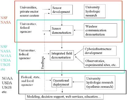
FIGURE 2-10 A summary of the steps involved in advancing from experimental development of a sensor through its operational deployment. The role of different, major activities and participants are shown as contributing to the process at different stages, and the federal agencies that would have major interest in these stages are also shown. USDA = U.S. Department of Agriculture.
in going from sensor development to operational deployment. There are many players involved in each step, and Figure 2-10 attempts to list them, and much on-going activity. Nonetheless, the process is far from smooth or seamless. As examples, current operational sensor networks generally have no plans to utilize new sensor and sensor networking technologies that would integrate various types of measurements to produce improved operational observations. At the same time, most university centers working on sensor development have no plans or resources to test their sensors within larger integrated field demonstrations that incorporate a variety of sensors, inter-connected through embedded networks and cyberinfrastructure for their potential delivery to data users.
From Figure 2-10, the committee sees Balkanization of the sensor development process, and subsequent gaps in agency programs, including potentially new roles for NSF as the nation’s primary research funding agency. Specific recommendations are offered in Chapter 5 for addressing these gaps.


