


Below is the uncorrected machine-read text of this chapter, intended to provide our own search engines and external engines with highly rich, chapter-representative searchable text of each book. Because it is UNCORRECTED material, please consider the following text as a useful but insufficient proxy for the authoritative book pages.
Cooper, A. K., P. J. Barrett, H. Stagg, B. Storey, E. Stump, W. Wise, and the 10th ISAES editorial team, eds. (2008). Antarctica: A Keystone in a Changing World. Proceedings of the 10th International Symposium on Antarctic Earth Sciences. Washington, DC: The National Academies Press. Antarctica and Global Paleogeography: From Rodinia, Through Gondwanaland and Pangea, to the Birth of the Southern Ocean and the Opening of Gateways T. H. Torsvik,1,2 C. Gaina,1 and T. F. Redï¬eld1 ABSTRACT correspondingly limited in scope. Geophysical techniques capable of resolving rock properties beneath the ice cover Neoproterozoic Rodinia reconstructions associate East Ant- have proved helpful to delineate the continentâs crustal struc- arctica (EANT) with cratonic Western Australia. By further ture, but often fail to shed light on Antarcticaâs geotectonic linking EANT to both Gondwana and Pangea with relative evolution. Thus, Antarctica remains the most geologically plate circuits, a Synthetic Apparent Polar Wander (SAPW) unexplored continent. path for EANT is calculated. This path predicts that EANT Extending from the Ross to the Weddell Seas, the Trans- was located at tropical to subtropical southerly latitudes from antarctic Mountains (Figure 1) effectively divide Antarctica ca. 1 Ga to 420 Ma. Around 400 Ma and again at 320 Ma, into two geological provinces: cratonal East Antarctica EANT underwent southward drift. Ca. 250 Ma Antarctica (EANT) and the collage of tectonic blocks that make up West voyaged brieï¬y north but headed south again ca. 200 Ma. Antarctica (WANT). Possessed of a long, globetrotting his- Since 75 Ma EANT became surrounded by spreading centers tory, portions of EANT can be traced to Rodinia and perhaps and has remained extremely stable. Although paleomagnetic even beyond. As a relative newcomer to the paleogeographic data of the blocks that embrace West Antarctica are sparse, parade, WANT comprises discrete tectonic blocks (Figure 1) we attempt to model their complex kinematics since the separated by rifts or topographic depressions. Mesozoic. Together with the SAPW path and a revised Today the Antarctic plate is neighbored by six different circum-Antarctic seaï¬oor spreading history we construct a tectonic plates and almost entirely surrounded by spreading series of new paleogeographic maps. ridges. This tectonic conï¬guration has in part given rise to Antarcticaâs near-total Cenozoic isolation. Two important INTRODUCTION hotspots (Kerguelen, Marion) lie within the Antarctic plate. The Bouvet hotspot, which may have been responsible for Antarctica is the worldâs last discovered wilderness, still the catastrophic Karroo igneous outpouring in Jurassic time, relatively poorly mapped, and the only continent without is now located near the AFR-SAM-ANT triple junction (Fig- an indigenous human history. Excepting the very tip of the ure 2). In this review we outline the location of the worldâs Antarctic Peninsula, the bulk of the Antarctic land mass ï¬fth largest continent and its neighbors in space and time, lies south of the Antarctic circle, and is covered by ice on a and present paleogeographic reconstructions for important year-round basis. Constrained to isolated nunataks, mountain periods of assembly and breakup. We give a list of acronyms chains, and coastal exposures, geological studies have been used in Table 1. 1 Center for Geodynamics, Geological Survey of Norway, Leiv Eirikssons EAST ANTARCTICA IN SPACE AND TIME vei 39, NO-7491 Trondheim (Norway) (trond.torsvik@ngu.no). 2 Also at PGP, University of Oslo, 0316 Oslo (Norway); School of EANT comprises Archaean and Proterozoic-Cambrian ter- Geosciences, Private Bag 3, University of Witwatersrand, WITS, 2050 (S. ranes that amalgamated during Precambrian and Cambrian Africa). times (Fitzsimons, 2000; Harley, 2003). Proterozoic base- 125
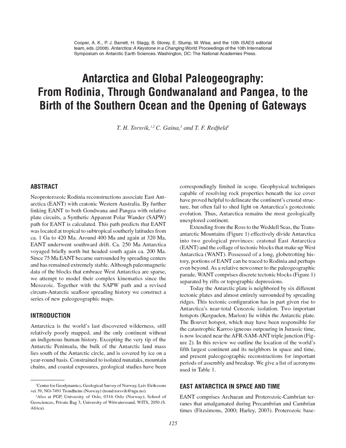
126 ANTARCTICA: A KEYSTONE IN A CHANGING WORLD FIGURE 1 Antarctic topography and bathymetry. East Antarctica is subdivided into four provinces (Lythe et al., 2000): DML, LHB, RAY, and a large undivided unit (EANT). West Antarctica consists of ï¬ve major distinctive terranes: AP (com- prising Eastern-Central-Western domains: ED-CD-WD), TI, FB, MBL, and EWM. The three northern Victoria Land terranes are grouped together (NVL). ROSS = ex- tended continental crust between MBL and EANT; TAM = Transantarctic Mountains (red and black lines). Most of the circum- Antarctic continent ocean boundaries (out- ermost polygon boundaries) are the result of nonvolcanic breakup except NW of DML (volcanic; red line) and Western AP (inactive trench, white and red lines) (see Table 1 for more abbreviations). ment provinces (Fitzsimons, 2003) link EANT and cratonic southerly latitudes from about 1 Ga to the Late Ordovician. Western Australia (WAUS, Australia west of the Tasman However, Precambrian data are sparse: This portion of the line), and consequently all reconstructions of Rodinia asso- SAPW path is based only on the ~1070 Ma Bangemall pole ciate EANT (including the mostly unknown EANT shield) (Wingate et al., 2002), the ~755 Ma Mundine pole (Wingate with WAUS in Neoproterozoic time. By further linking and Giddings, 2000) and several ~600 Ma poles from WAUS. EANT to Gondwana at ~550 Ma, Pangea at ~320 Ma, and During Late Ordovician and Silurian times (~450-400 Ma), breakup at ~175 Ma with relative plate circuits we are able EANT drifted southward (8-11 cm/yr; latitudinal velocity to construct a Synthetic Apparent Polar Wander (SAPW) calculated from Figure 3b), followed by another phase of path for EANT (Figure 3) based on Australian paleomag- southward drift during the Carboniferous (350-300 Ma; 6-11 netic data, Gondwana poles (550-320 Ma) (Torsvik and Van cm/yr). The Permo-Triassic (300-200 Ma) was characterized der Voo, 2002), and a global data compilation for the last by northerly motion (~5 cm/yr); southerly drift (2-7 cm/yr) 320 million years describing Pangea assembly and breakup again recommenced after 200 Ma. For the last 75 Ma, EANT (Torsvik et al., forthcoming). The SAPW path also includes has remained extremely stable (~0.6 cm/yr) near the South palaeomagnetic data from EANT (listed in Torsvik and Van Pole. der Voo, 2002) whenever considered reliable. Within error, EANT was located near the equator in the Early Paleo- EANT poles match the SAPW path (Figure 3a). zoic (Figure 3b). Marine invertebrates ï¬ourished in tropical The SAPW path (Table 2) predicts that a given location seas and the continent hosted a varied range of climates, in EANT (Figure 3b) was located at tropical to subtropical from deserts to tropical swamps. Excepting a period of
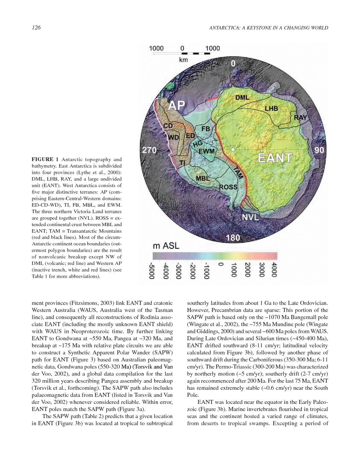
TORSVIK ET AL. 127 FIGURE 2 Age of the ocean ï¬oor sur- rounding Antarctica. White arrows show âabsoluteâ motion of some tectonic plates based on a moving hotspot frame for the last 5 million years. Red circles denote hotspot locations (BH = Bouvet; KH = Kerguelen; MH = Marion; RH = Reunion; SH = St. Hel- ena; TH = Tristan). Large igneous provinces and other volcanic provinces (including seaward-dipping reï¬ectors) are shown in brown and white. Active plate boundaries shown in black (midocean ridges) and ex- tinct midocean ridges in grey. Inset ï¬gure shows isochrons based on present-day mag- netic and gravity data. ScSea = Scotia Sea (see Table 1 for more abbreviations). northerly drift into temperate latitudes near the Triassic- Thus, we restrict our description and paleomagnetic analy- Jurassic boundary (~200 Ma), EANT has remained in polar sis (following the pioneering work of Grunow, Dalziel, and latitudes for the last 325 myr. Consequently, EANT has com- coworkers) to the Antarctic Peninsula (AP), Thurston Island monly been inundated by ice. However, the ï¬rst recognized (TI), and the Ellesworth-Whitmore Mountains (EWM). In Phanerozoic glacial eventâthe short-lived Late Ordovician addition, relative movements between individual blocks or Hirnantian (ca. 443 Ma) glacial episodeâoccurred while vs. EANT (e.g., Jurassic poles in Figure 4a) are sometimes EANT occupied temperate latitudes. During this time, NW only slightly greater than the resolving power of the paleo- Africa was located over the South Pole (Cocks and Torsvik, magnetic method. 2002). Conversely, during the Late Paleozoic glacial inter- AP has traditionally been treated as a single Mesozoic-to- val, commencing in the Late Carboniferous and lasting for Cenozoic continental arc system formed above an eastward- almost 50 myr, the South Pole was located in EANT (Torsvik dipping paleo-Pacific subduction zone. Recent studies, and Cocks, 2004). These Permo-Carboniferous glaciations however, suggest that AP consists of three fault-bounded resulted in deposition of widespread tills across South Pan- terranes (WD, CD, and ED in Figure 1) that amalgamated in gea (Gondwana). Late Cretaceous (Albian) time (Vaughan and Storey, 2000; Vaughan et al., 2002). However, for reasons of simplicity we keep AP blocks together in our reconstructions. Jurassic WEST ANTARCTICA AND PALAEOMAGNETIC DATA to Early Cretaceous (between 175 Ma and 140 Ma) paleo- In contrast with the great lumbering elephant of continental magnetic poles from AP differ from the EANT SAPW path EANT, WANT comprises several distinct crustal blocks while Early Cretaceous (110 Ma) and younger poles overlap (Dalziel and Elliot, 1982), with independent Mesozoic and within error (Figure 4a). The data are therefore compatible Cenozoic geotectonic histories (Figure 1). Because many with models that imply that AP moved away from EANT are inadequately sampled paleomagnetically, it is difï¬cult between 175 and 140 Ma while undergoing slow clockwise to portray their latitudinal story with great confidence. rotation (Weddell Sea opening at ~5 cm/yr) (Figure 4b) fol-
128 ANTARCTICA: A KEYSTONE IN A CHANGING WORLD TABLE 1 Commonly Used Abbreviations AFR Africa plate ANT Antarctic plate AP Antarctic Peninsula (now part of WANT) AUS Australia DML Dronning Maud Land, includes the Grunehøgna terrane (part of the Kapvaal Archean core of the Kalahari craton, and the Maud orogen and perhaps part of the Coats Land crustal block) (now part of EANT) EANT East Antarctica EWM Ellesworth-Whitmore Mountains (now part of WANT) FB Filchner Block (as deï¬ned by Studinger and Miller (1999), partly Coats Land cratonic block and partly extended and intruded âAfar depression likeâ continental crust (Dalziel and Lawver, 2001) (now part of WANT) FI Falkland Island (now part of SAM) HG Haag (included in EWM) LHB Lützow-Holm Bay (now part of EANT) KAL Kalahari (now part of SAFR) MBL Marie Byrd Land (now part of WANT) MEB Maurice Ewing Bank (now part of SAM) NAZ Nazca plate P Patagonia (now part of SAM) PAC Paciï¬c plate RAY Raynor Province (now part of EANT) SAFR South Africa SAM South American plate ScSea Scotia Sea TI Thurston Island (now part of WANT) WANT West Antarctica WAUS Western Australia, Cratonic Australia west of the Tasman line (now part of AUS) lowed by convergence (Weddell Sea partial subduction) and A PALEOGEOGRAPHIC PARADE clockwise rotation (~130-110 Ma) relative EANT (see also Below we present eight paleogeographic maps from Neo- Grunow, 1993). proterozoic to Early Tertiary times. Global reconstructions TI has few exposures, but available data indicate that TI are based on relative ï¬ts and paleomagnetic APW paths was similar morphologically and tectonically to AP (Leat et (Torsvik and Van der Voo, 2002; Torsvik et al., forthcoming), al., 1993). 110 and 90 Ma poles (Figure 4a) are grossly simi- upgraded with reconstruction parameters for Antarctica and lar to those from AP and EANT. In our reconstructions (Table surrounding plates (Table 3). Paleomagnetism yields only aleomagnetism 3) (Grunow, 1993), TI follows the overall motion of the AP latitudes and plate rotations, but longitudinal uncertainty blocks (see velocity pattern in Figure 4b). However, TI was can be minimized if the continent that has moved least in emplaced in its present position at the southern end of the AP longitude can be identiï¬ed and is used for reference: Africa by some ~300 km dextral movement and several degrees of is the best candidate (Burke and Torsvik, 2004). In order to clockwise rotation between 130 Ma and 110 Ma. reconstruct the continents in the best possible âabsoluteâ EWM is a displaced segment of the cratonic margin manner we here use a hybrid reference frame based on merg- (Schopf, 1969) whose past position is constrained by ing an African mantle frame (OâNeil et al., 2005; Torsvik et Late Cambrian (e.g., Grunow et al., 1987; Randall and al., forthcoming) and a paleomagnetic reference frame (>100 MacNiocaill, 2004) and Jurassic paleomagnetic data (Grunow Ma) back to the time of Pangea assembly (~320 Ma). The et al., 1987) (Figure 4a). EWM was probably located in the paleomagnetic frame (110-320 Ma), calculated in African Natal Embayment of the African plate in Cambrian times coordinates, was adjusted 5° in longitude to correct for the and underwent 90° counterclockwise rotation during Pangea longitudinal motion of Africa during the past 100 Ma inferred breakup. A 175 Ma pole (Figure 4a) from EWM overlaps in the mantle reference frame. Reconstructions 250 Ma and with a contemporaneous pole from AP (Figure 4a). However, younger are therefore shown in a absolute sense with paleo- we keep EWM near EANT during Late Jurassic-Early Cre- longitudes and/or velocity vectors with respect to the Earthâs taceous times by interpolating its position with the ~175 Ma spin axis. While it could prove possible to quantify uncertain- pole and its current position ï¬xed to EANT (here modeled ties in velocity vectors for the mantle frame (see OâNeil et to 120 Ma). This implies ~1.3 cm/yr of sinistral movement al., 2005), velocity vector uncertainties in the paleomagnetic vs. EANT (Figure 4b). frame (110-320 Ma) cannot be quantiï¬ed since we assume âzero longitudeâ movement for Africa.
TORSVIK ET AL. 129 FIGURE 3a Synthetic APW path for EANT (Table 2, see text). Running mean poles (20 Ma window; 10 Ma intervals) are shown with A95 conï¬dence circles (blue color). We also show actual input poles with dp/dm ovals (light brown) from EANT that were included in the calculation of the SAPW path. FIGURE 3b Latitude for a geographic location (90°S) in EANT based on the SAPW path in Figure 3a. However, the last 100 Ma is calculated from a moving hotspot frame. We show actual Phanerozoic latitudinal data from EANT (recalculated to 90°S) with error bars. Yellow stars denote the times of reconstructions shown in the paper. PM = Palaeomagnetic data, and where the oldest section is based on paleomagnetic data from cratonic WAUS, then mean data from Gondwana (550-320 Ma), and ï¬nally global data until 110 Ma.
130 ANTARCTICA: A KEYSTONE IN A CHANGING WORLD TABLE 2 Phanerozoic Synthetic Apparent Polar Wander (SAPW) Path for EANT Age (Ma) N A95 Lat. Long. 0 18 3.0 â87.8 308.3 10 30 2.5 â87.5 296.8 20 23 2.9 â86.1 307.4 30 18 2.7 â84.9 327.9 40 19 2.8 â85.3 326.6 50 27 2.5 â83.8 338.3 60 30 2.4 â84.4 010.3 70 20 2.6 â84.4 050.7 80 23 2.8 â87.8 010.3 90 27 2.6 â89.2 206.4 100 11 4.2 â86.1 191.6 110 16 3.4 â78.2 181.4 120 24 2.3 â76.1 179.0 130 18 3.1 â75.3 179.1 140 10 5.6 â75.2 191.9 150 16 6.4 â69.6 224.3 160 14 6.0 â62.9 228.1 170 23 3.8 â57.5 222.5 180 26 3.6 â55.3 226.0 190 31 3.5 â50.1 237.0 200 35 3.2 â51.9 243.9 210 32 2.7 â55.4 251.0 220 29 2.0 â58.5 257.8 230 28 2.6 â63.5 257.4 240 35 3.7 â70.1 248.5 250 38 4.3 â73.8 231.9 260 26 4.8 â75.7 224.9 270 28 3.4 â81.4 226.3 FIGURE 4 (a) Jurassic-Cretaceous poles from AP, EWM, and 280 57 2.4 â86.4 228.9 TI (mean poles with A95 ovals except 175 Ma EWM pole, dp/dm 290 70 1.9 â88.0 251.5 ovals) (Grunow, 1993). We also show the timing of some large 300 39 2.4 â89.6 074.2 igneous province events (red stars) that must have had an effect 310 20 4.8 â86.8 041.7 on Pangea in general (C = Central Atlantic Magmatic Province) or 320 9 9.3 â81.4 358.9 directly affected Antarctica and its margin (K = Karroo; M = Maud 330 4 9.7 â80.2 348.2 Rise/Madagascar Ridge). (b) Velocity for TI (74°S, 248°E), AP 340, 350 1 ââââ â38.2 035.2 (72°S, 290°E) and EWM (81°S, 271°E) relative to a ï¬xed EANT. 360 5 12.5 â48.9 003.1 Colored arrows show sense of rotation relative to EANT. Poles in 370 8 16.7 â49.0 007.7 380 5 35.1 â45.8 002.7 (a) are compared with the EANT SAPW path (yellow A95 ovals) 390 2 138.6 â36.4 348.7 as in Figure 3a for the last 200 Ma, but ï¬tted with small circles that 400 1 ââââ â33.9 017.6 have RMS values less than 0.6°. Abrupt changes in the balance of 440, 450 1 ââââ â1.8 006.1 forces driving and resisting plate motions should be noticed in the 460 2 99.0 â2.3 019.1 APW paths as cusps. 470 5 13.8 â4.4 021.2 480 7 7.7 â11.3 024.4 490 7 12.7 â11.5 028.9 500 7 15.7 â16.6 022.2 510 9 7.6 â21.7 010.4 520 9 9.3 â20.0 007.8 530 8 13.7 â17.9 352.1 Rodinia 540 10 10.7 â17.7 328.6 550 7 14.1 â16.8 323.1 The identiï¬cation of 1300-1000 Ma mountain belts (Grenvillian, Sveconorwegian, and Kibaran) presently NOTE: N = number of poles; A95 = 95 percent conï¬dence circle; Lat., Long. located on different continents caused geologists of the = mean pole latitude, longitude. 1970s to postulate a Precambrian supercontinent (e.g., Dewey and Burke, 1973). Thus, since the early 1990s, Pre- cambrian reconstructions have consistently incorporated a vaguely resolved Neoproterozoic supercontinent, Rodinia (Hoffman, 1991; Dalziel, 1992, 1997; Torsvik et al., 1996) (Figure 5), postulated to have amalgamated about 1.0 Ga and to have disintegrated at around 850-800 Ma (Torsvik,
TORSVIK ET AL. 131 TABLE 3 Important Relative Reconstruction Parameters 2003). However, despite exhaustive research for more than Discussed in the Text and Shown in Figures 5â9 15 years, including new paleomagnetic studies as well as Age Continents Lat. Long. Ang. dating of mobile belts and rift sequences associated with Rodiniaâs breakup, the details of Rodinia remain obscure. 750-250 DMLâKAL 10.5 148.8 â58.2 750-130 EANT-WAUS 11.1 â137.2 â29.7 The paleolatitudes of only a few of Rodiniaâs constituent 750-250 EWM-KAL 56.8 â086.1 92.7 continents are known at any given time, and in addition to 750-250 FI-KAL 31.6 164.8 â119.5 nonconstrained longitudes, the hemispheric position of the 750-250 MEB-KAL 44.3 â032.6 58.9 individual continents is uncertain. 750 MBL-EANT 68.4 023.9 57.1 In Rodinia times WAUS and EANT were clearly linked 250, 180 AP-EANT 72.3 086.8 â35.5 250-99 MBL-EANT 47.2 146.2 â3.0 as illustrated by the two-stage Albany-Fraser-Wilkes orogen 250 EWM/FB-EANT 81.9 134.1 97.6 (1350-1260 Ma and 1210-1140 Ma) (red shading in Figure 5) 250 P-SAFR 47.5 â033.2 63 and also the older Mawson Craton (Fitzsimons, 2003). We do 250, 180 TI-EANT 73.6 089.6 â49.2 not associate India with WAUS-EANT as portrayed in many 180 EWM/FB-EANT 33.1 078.7 â9.0 classic Rodinia reconstructions; rather, we consider them to 180 FI-SAFR 32.2 164.0 â119.3 180 MEB-SAFR 44.9 â032.9 58.7 have amalgamated during Gondwana assembly (Fitzsimons, 180 P-SAFR 47.5 â033.1 61.3 2000; Torsvik et al., 2001; Torsvik, 2003; Meert, 2003; 160 AP-EANT 23.9 â027.0 â11.9 Collins and Pisarevsky, 2005). The Napier Complex, LHR, 160 EWM/FB-EANT 69.9 093.7 â23.5 and RAY (currently part of EANT) probably belonged to 160 P/FI/MEB-SAFR 47.5 â033.3 58.0 India prior to Pan-African collision (Figure 6). 160 TI-EANT 60.3 â004.6 â20.6 130 AP-EANT 77.9 079.7 â16.4 Rodinia probably formed between 1100 Ma and 1000 130 EWM/FB-EANT 69.9 093.7 â5.9 Ma , and breakup probably occurred before 750 Ma. Rup- 130 P/FI/MEB-SAFR 48.5 â033.4 56.1 ture may have commenced with the opening of an equato- 130 TI-EANT 74.6 102.1 â31.1 rial ocean between western Laurentia and WAUS-EANT. 99 EANT-AUS 5.7 034.6 27.8 Dronning Maud Land (DML; including the Grunehøgna 99 P/FI (SAM)-SAFR 56.0 â034.8 42.7 50 EANT-AUS 13.0 032.9 24.7 terrane), and EWM (currently part of EANT and WANT) 50 MBL-EANT 18.2 162.1 â1.7 were probably linked to Kalahari (South Africa) during the 50 SAM-SAFR 58.2 â031.2 20.5 Neoproterozoic (Figure 5). NOTE: Lat., Long., Ang. = Euler pole latitude, longitude, angle. EWM, FB, TI, and AP ï¬xed to EANT from ca. 110 Ma. Fits derived from this study, Dalziel (1997) (MBL), or interpolated from Grunow (1993) and Torsvik et al. (forthcoming). FIGURE 5 750 million year reconstruc- tion of Rodinia just after breakup (âRo- dinia Newâ of Torsvik, 2003). Kalahari (no paleomagnetic data) has been modiï¬ed to include DML, FI, MEB, and EWM. Outline of the Albany-Fraser-Wilkes Oro- gen (AFWO) in WAUS and EANT follows Fitzsimmon (2003). Low-latitude position of Tarim next to EANT and WAUS (Huang et al., 2005) is problematic since it has to be removed before collision with India. MBL after Dalziel (1997). However, the location and even existence of MBL at this time is uncertainâoldest MBL rocks are Cambrian but a Proterozoic basement age cannot be excluded (Leat et al., 2005).
132 ANTARCTICA: A KEYSTONE IN A CHANGING WORLD FIGURE 6 Late Cambrian reconstruction of Gondwana (inset globe) and a detailed reconstruction of EANT, SAFR (Kalahari), WAUS, India, and parts of present day SAM (P, FI, MEB). Craton outlines and orogenies mostly after Leat et al. (2005). Position of EWM (Table 3) is based on ï¬tting Late Cambrian paleomagnetic data within error to also allow space for a smaller FB than of today. Terranes and blocks in the Natal Embayment were not affected by Pan-African deformation (see Table 1 for more abbreviations). Gondwana the Namaqua-Natal belt (SAFR) and the Maudheim province (DML). We further infer that the EWM terrane belonged to Breakup of Rodinia and the subsequent formation of Gond- this province (Leat et al., 2005), and we associate all of the wana at ~550 Ma were marked by protracted Pan-African above terranes and blocks with Kalahari in Rodinia times tectonism, one of the most spectacular mountain-belt build- (Figure 5). EWM basement is not exposed but ~1.2 Ga ing episodes in Earth history. Gondwana incorporated all of Grenvillian Haag Nunataks gneisses (Millar and Pankhurst, Africa, Madagascar, Seychelles, Arabia, India and EANT, 1987) are considered to underlie it (Figures 5 and 6). Paleo- most of South America and AUS, and probably some WANT magnetic (e.g., Randall and MacNiocaill, 2004), structural blocks (EWM, FB?). The surface area of Gondwana totaled and stratigraphic data have been used to argue that EWM was 95 106 km2, some 64 percent of todayâs landmasses or situated near Coats Land (DML) until the Jurassic. In our 19 percent of the Earthâs surface (Torsvik and Cocks, slightly modiï¬ed EWM ï¬t (Figure 6) (Table 3) we maintain forthcoming). a similar connection until the early Jurassic (~200 Ma). We In the Late Cambrian, Gondwana (Figure 6, inset globe) allow space for a slightly smaller FB than of today by assum- stretched from polar (NW Africa) to subtropical northerly ing later Mesozoic extension. latitudes (AUS). EANT covered equatorial to subtropical The Pan-African orogenies that stabilized EANT took southerly latitudes. As most reconstructions, we show the place in two main zones (Figure 6): (1) in a broad region Falklands Islands (FI), the Maurice Ewing Bank (MEB), the between the Shackleton Range, the Bunger Hills caused EWM and FB block located near South Africa, and DML by collision with South Africa (including the Kalahari and (Figure 6) (Table 3)âthe Natal Embayment. The FI block Grunehøgna cratons, now part of EANT), and India (includ- was situated within a ca. 1.1 Ga orogen that also included ing the Napier Complex), and (2) along the Transantarctic
TORSVIK ET AL. 133 FIGURE 7 (a) 250 Ma reconstruction. Black thick line denote the Permian-Early Mesozoic Gondwanide orogen (Dalziel and Grunow, 1992). PM = Pensacola Mountains (EANT); CL = Coats Land (DML). (b) 180 Ma reconstruction with distribution of the ca. 179-184 Ma Karroo and Ferrar volcanic provinces (LIPs) in SAFR, FI, and EANT and the silicic Chon Aike province (188-153 Ma) located to SAM (P), AP, EWM, and TI (Pankhurst et al., 2000). BH = Bouvet hotspot. White arrows denote absolute plate motion vectors. Mean plate velocities indicated for EANT and Patagonia (P) in (b). The background grid images represent structures in the lower mantle that are long- lived and at regular intervals give rise to plumes and plume-related LIPs (Torsvik et al., 2006). The thick background red line in these images is the potential plume genera- tion zone (e.g., underlying Bouvet in [b]) (see Table 1 for more abbreviations). Mountains (Ross Orogeny), still active in Late Cambrian in Figure 7a) during the Late Paleozoic-Early Mesozoic times (Leat et al., 2005, and references therein). The hub of (Torsvik and Cocks, 2004). Permo-Triassic structures in Pan-African metamorphism between East Africa and EANT South America (Argentina), South Africa (Cape Fold Belt), (~580-550 Ma) (Jacobs and Thomas, 2004) is exposed in FI, EWM, and ANT (Pensacola Mountains) suggest that DML. Conversely, blocks in the adjoining Natal Embayment an enigmatic Gondwanide orogen (Figure 7a) may have (e.g., EWM) (Figure 6) escaped both the East Africa-EANT developed in response to subduction-related dextral com- and Ross orogens. Curtis (2001) suggested rifting along pression along the convergent SW margin of Gondwana the Paleo-Paciï¬c margin, otherwise characterized by active (Johnston, 2000). subduction, while Jacobs and Thomas (2004) argued for a Most plate tectonic models assume that the FI block lateral-escape scenario. originated off the SE coast of Africa and subsequently rotated ~180° from its current orientation in the Jurassic (e.g., Adie, 1952; Marshall, 1994; Dalziel and Lawver, Pangea 2001). This is required both by paleomagnetic data (e.g., From ~320 Ma onward Gondwana, Laurussia, and inter- Mitchell et al., 1986) from Jurassic dykes (Karroo aged) vening terranes merged to form the supercontinent Pangea. and by excellent correlations between the basement and the Pangeaâs main amalgamation occurred during the Carbonif- overlying Middle and Late Paleozoic strata of South Africa erous, but Pangeaâs dimensions were not static. Some con- with the stratigraphy of the FI (Marshall, 1994). Restoration tinents were subsequently added along the supercontinent to a position adjacent to SE Africa is also suggested by the margins, and others rifted away (e.g., opening of Neotethys structural correlation of the eastern Cape Fold Belt with fold
134 ANTARCTICA: A KEYSTONE IN A CHANGING WORLD and thrust trends on the Falklands (Figure 7a). The collective data demand that FI have rotated nearly 180°. However, the timing (modeled here between 182 Ma and 160 Ma) and the exact processes responsible for this during separation from southeast Africa remain unclear. The anticlockwise rotation of EWM relative to EANT would be even more difï¬cult to explain if we took into account the presence of another continental crustal block, the Filchner Block (FB) (as deï¬ned by Studinger and Miller, 1999) thought to comprise cratonic blocks (Coats Land) and extended continental crust and not oceanic crust. Pangea ruptured during the Jurassic, preceded by and associated with widespread magmatic activity, including the Karroo ï¬ood basalts and related dyke swarms in South Africa and the FI, and the Ferrar province in EANT (Figure 7b). The initial catastrophic outpouring of this deep plume- related LIP event (Torsvik et al., 2006), possibly linked to the Bouvet hotspot, probably triggered the Toarchian (183 ± 1.5 Ma) global warming event (Svensen et al., 2007). Karroo and Ferrar magmatism partly coincided with the more prolonged Chon Aike rhyolite volcanism (Figure 7b), and subduction-related magmatism along the Proto-Paciï¬c margin of Gondwana (Rapela et al., 2005). Absolute plate motions (Figure 7) show a change from northeast (250 Ma) through southwest (180 Ma) to southward motion from 170 Ma until the end of the Jurassic. A near 90° cusp in the SAPW path (Figure 4a) at around 170 Ma docu- ments an abrupt change in plate driving forces. Unless caused by true polar wander we tentatively link this plate change to a combination of plume activity impinging the south Pangea lithosphere and subduction rollback. Because the subduction angle varied greatly, rollback must have been differential. Thus, we infer Patagonia (P) experienced a strong rollback effect, which we model (Figure 7a) with an offset of about 600 km compared to the present-day location in SAM. In our reconstructions SAM is broken into several discrete blocks whose borders behave as plate boundary scale deformation zones. This is necessary to understand and to reconstruct not only the FI drift story but also the Cretaceous opening history of the South Atlantic. FIGURE 8 Oceanic paleo-age grids and reconstructed continental CIRCUM-ANTARCTIC SEAFLOOR SPREADING SINCE blocks of Gondwana at 160 Ma and 130 Ma. Continental blocks: THE LATE JURASSIC CP = Campbell Plateau; M = Madagascar (see Table 1 for more ab- breviations). Oceanic plates: FAR = Farallon; IZA = Izanaghi, PAC Preserved oceanic crust characterized by distinctive mag- = Paciï¬c; PHX = Phoenix. Oceanic basins: ThO-Neotethys, PPAC = netic and gravity signatures allows us to reconstruct the age Paleo-Paciï¬c oceans, Wsea = Weddell Sea, RLSea = Riiser-Larsen and extent of oceanic crust through time. However, subduc- Sea; MB = Mozambique basin; EB = Enderby Basin; PAP = Perth tion, complex seaï¬oor spreading or massive volcanism can Abyssal Plain. Hotspots: BH = Bouvet, MH = Marion. XR indicates destroy or overprint this structure. In such cases geological location of extinct ridges, toothed grey lines show location of sub- duction, thick white arrows between southern block of SAM and FB and geophysical data from continental area are the only con- indicate extension. Red arrows indicate ï¬rst Gondwana breakup in straints for plate reconstructions. In the following we present the RLSea. Absolute motion vectors shown as white lines. WANT circum-Antarctic reconstructions that take into account both blocks are connected by uncertain crust type (light brown color); continental and oceanic area evidences of plate motions. this can be extended continental crust or oceanic crust that has sub- For oceanic areas we show the oceanic paleo-age modeled sequently been subducted or obducted. Inset ï¬gures show isochrons according to magnetic and gravity data of the preserved crust. based on present-day magnetic and gravity data.
TORSVIK ET AL. 135 In the case of a single preserved ï¬ank we assume symmetric Gondwana Breakup spreading, and in the case of restoring complete oceanic Long-lived subduction in the southern Paciï¬c realm facili- basins, we assume symmetric spreading and rates according tated the amalgamation and accretion of several terranes to the distances between the two margins whose locations to westernmost ANT (Vaughan and Storey, 2000). Recent are established by independent data (i.e., not oceanic crust geophysical data and models propose that extension between data). different continentally afï¬liated blocks of WANT achieved Our reconstructions show vectors of motions for the high degrees of extension but did not develop into seaï¬oor major continents, which are based on stage poles that spreading. Rotation, local subduction, and back-arc spread- indicate the average motion between the continent and ing may ï¬rst have displaced and later reamalgamated AP underlying mantle for the last 5 million years before the age blocks (Vaughan et al., 2002). of the reconstruction. These stage poles are based on our It has proved difï¬cult to reach a consensus between hybrid reference frame and global plate circuit (Torsvik et motion described by paleomagnetic data and other geological al., forthcoming) that include ï¬nite rotation poles between and geophysical evidence. We therefore treat the Mesozoic tectonic plates inferred both quantitatively and qualitatively, WANT domain as a collection of island arc and continental based on paleomagnetic data, magnetic and gravity data, blocks in a matrix of extended or not well-deï¬ned crust until and geological data. Due to the complexity of the database, 61 Ma (i.e., when extension between EANT and WANT plate circuits, and range of errors involved in our analysis, a commenced) (Cande and Stock, 2004). Seaï¬oor spreading method to quantify the resulting errors of our motion vectors in the Paciï¬c region has been quantiï¬ed using the oldest is not yet developed, but an estimation of several degrees are preserved magnetic anomalies that describe the relative expected for a direction deviation. motion between the nascent Paciï¬c plate and neighboring Isotopic ages of rocks from the southernmost Andes Izanagi (completely subducted under Eurasia), Farallon (par- and South Georgia Island, North Scotia Ridge revealed that tially subducted under North America) and Phoenix (almost the formation of oceanic crust in the Weddell Sea region completely subducted under WANT, SAM, and AUS) plates. occurred by the Late Jurassic (150 ± 1 Ma) (Mukasa and Most of the conjugate plates are now completely subducted Dalziel, 1996), but interpretation of new geophysical data and thus we assume symmetric seaï¬oor spreading. indicates that Gondwana breakup probably commenced in Late Jurassic and Early Cretaceous motion vectors show the Weddell Sea (Figure 8) at ~160 Ma and propagated clock- a general southward trend (Figure 8) that we attribute to wise around ANT (Ghidella et al., 2002; Jokat et al., 2003; subduction rollback. Africa and South America moved more König and Jokat, 2006). Early AFR-ANT spreading offshore slowly than the block formed by EANT, India, Seychelles, DML has been dated to ~153 Ma (M24) in the Lazarev and Madagascar, and AUS. Consequently, seaï¬oor spreading Riiser-Larsen Seas (Roeser et al., 1996; Jokat et al., 2003). started to develop between these two sub-blocks of Gond- A new model for the early Indian-ANT spreading system wana in the Weddell Sea, Riiser-Larsen Sea, Mozambique, in the Enderby Basin (Figure 8) places the onset of seaï¬oor and Somali basins. König and Jokat (2006) proposed that a spreading at ~130 Ma (M9) (Gaina et al., 2003, 2007), con- long phase of extension and rifting took place in the southern sistent with the opening history between India and AUS in Weddell Sea before the onset of seaï¬oor spreading dated the Perth Abyssal Plain. around 147 Ma (M20). Older magnetic anomalies have been Early AUS-ANT spreading east of the Vincennes Frac- identiï¬ed in the Riiser-Larsen Sea (M24 at ~154 Ma) by ture Zone (~105°E) has been identiï¬ed by a Late Cretaceous Roeser et al. (1996), who consequently proposed ~165 Ma ridge system between Chron 34 (~83.5 Ma) and 31 (~71 Ma) breakup time between EANT and Africa. At the same time, (Tikku and Cande, 1999). In the south Tasman Sea between the southern Lazarev Sea (described as a continental margin) eastern AUS and the Lord Howe Rise and New Zealand, was affected by multiple rifting episodes accompanied by seaï¬oor spreading began in the late Cretaceous (~83.5 Ma). transient volcanism (Hinz et al., 2004). Spreading propagated northward to the Coral Sea in the Our 160 Ma reconstruction (Figure 8) shows the Bouvet Tertiary, terminating at ~52 Ma (Gaina et al., 1998). Seaï¬oor plume located at the boundary between EANT and Africa. spreading east of AUS is combined with models that include Although plume-related breakup is controversial, this recon- incipient motion between EANT and WANT (Cande et al., struction reinforces a possible relationship between breakup, 2000; Stock and Cande, 2002; Cande and Stock, 2004). seaï¬oor spreading, and volcanism initiated at the Explora The evolution of the South Paciï¬c region (Eagles et Wedge. This may also explain the multiple rift relocation in al., 2004) has been supplemented with reconstructed sea- the southern Riiser-Larsen Sea and early seaï¬oor spreading ï¬oor formed in the Paciï¬c realm and subducted beneath that later propagated west into the Weddell Sea. WANT. The conï¬guration of these âsynthetic platesâ was established on the basis of preserved magnetic lineations, paleogeography, regional geological data, and the rules of plate tectonics.
136 ANTARCTICA: A KEYSTONE IN A CHANGING WORLD 130 MaâEastward Propagation of Seaï¬oor Spreading: Circum-Paciï¬c realm. Besides the inception of rapid north- Antarctica-India-Australia Breakup ward drift of the Australian plate that caused rapid accretion of oceanic crust on the EANT plate, a major plate tectonic During the mid-Cretaceous, seaï¬oor spreading propagated reorganization has been recently reported between Australia eastward from the Riiser-Larsen Sea to the Enderby basin and Antarctica (Whittaker et al., 2007). This major event between EANT and India (Gaina et al., 2007). At the same time, India broke off from Australia (Figure 8), forming ocean basins west of Australia (Perth, Cuvier, and Gas- coyne abyssal plains) (Mihut and Müller, 1998; Heine et al., 2004). It is unclear what triggered this event. The earliest mag- matic activity in the Kerguelen area is dated to ca. 118 Ma (Frey et al., 2000; Nicolaysen et al., 2001) and the EANT margin in the Enderby basin is a nonvolcanic margin. Mag- matic activity, however, did occur further to the west (i.e., the ~125 Ma Maud Rise LIP) (offshore DML and EANT) (Torsvik et al. 2006). We link this event with Bouvet hotspot activity (Figure 8, ~130 Ma). Motion vectors for the Indian-Madagascar-Seychelles triplet at 130 Ma (Figure 8b) show rapid northward move- ment. We speculate that a possible Tethyan ocean ridge subduction under Eurasia caused the acceleration of India and also a southward ridge jump north of India and north- west of Australia (Heine et al., 2004). A signiï¬cant cusp (>90°) is recognized in the SAPW path at around 130 Ma signifying a major change in plate driving forces for EANT. Initial exhumation of the Transantarctic Mountains may have begun at this time in the Scott Glacier region (Fitzgerald and Stump, 1992), suggesting onset of extension between EANT and WANT. 99 MaâAbrupt Change in Relative Velocity A dramatic acceleration of the Indian (and AFR) plate modi- ï¬ed the seaï¬oor spreading geometry north of Enderby Land and west of AUS (Müller et al., 2001). At the same time, the Paciï¬c plate swerved and accelerated (Veevers, 2000) bringing long-lived subduction under the Australian and New Zealand plates to a halt (Figure 9). Transtensional regimes that followed this change in the Paciï¬c plate motion led to the opening of the Tasman Sea east of AUS (Gaina et al., 1998) and rifting of the Chatham Rise, Campbell Plateau (and South New Zealand) from the MBL block (Cunningham et al., 2002). It is noteworthy that increased spreading rates between EANT and India (AFR), from ~3 cm/yr at 100 Ma to ~7 cm/yr at 90 Ma (Figure 10), was not associated with any abrupt changes in the SAPW path (Figure 4a). 50 MaâMajor Change in Plate Driving Forces as a FIGURE 9 Paleo-age for reconstructed oceanic crust at 99 Ma and Precursor to Opening of Oceanic Gateway 50 Ma. Oceanic basins. IND = Indian, SATL = South Atlantic; SOC = Southern Ocean; AT = Adare Trough, ST = South Tasman; DP = While related to plume drift as opposed to a change in plate Drake Passage. The Southern Hemisphere ocean gateways opened motion, the bend in the Hawaiian-Emperor (recently revised at around 33 Ma and 30 Ma, respectively. Inset ï¬gures show iso- from 43 Ma to 48 Ma) (Sharp and Clague, 2006) apparently chrons based on present-day magnetic and gravity data (see Figure does reï¬ect a major tectonic event that affected much of the 8 and Table 1 for explanation of abbreviations).
TORSVIK ET AL. 137 FIGURE 10 Mean plate rates of predrift deformation and seafloor spreading for AUS, India, and SAFR vs. EANT. (perhaps even global) that coincides with the Hawaiian- By the dawn of the Oligocene (~33.5 Ma) (Exon 2002) the Emperor bend time was correlated to the subduction of gateway reached full marine conditions. Seaï¬oor spreading the Paciï¬c-Izanagi active spreading ridge and subsequent in the Drake Passage and Scotia Sea region is generally con- Mariana-Tonga-Kermadec subduction initiation (Whittaker sidered to have commenced before 26 Ma (Barker, 2001) or et al., 2007). 29.7 Ma (Eagles and Livermore, 2002). Relative extension between EANT and WANT com- menced in the Late Cretaceous-early Tertiary, but oceanic EPILOGUE crust between these two plates was formed only between 45 Ma and 30 Ma in the Adare Trough of the Ross Sea (Cande et Far from static, Antarctica has traveled long distances, in al., 2000) (Figure 9). Rapid extension-related exhumation of both space and time. The most ancient fragments once the Transantarctic Mountains (TAM) at ~55 Ma is well docu- basked beneath a tropical Precambrian sun, in communion mented (Fitzgerald and Gleadow, 1988; Fitzgerald, 2002), with cratonic West Australia and enveloped in a loosely but the cause of this uplift is still unresolved. Two competing deï¬ned supercontinent, Rodinia. Playing an active role in hypotheses seem pertinent: Fitzgerald et al. (1986) suggested Rodinia breakup and Gondwana assembly at the dawn of a classic asymmetric extension process, while Stern and ten the Paleozoic, Antarctica commenced a long southward drift Brink (1989) proposed an elegant model based on the ï¬exural in Late Ordovician time. During the transit to its present up-warp of a broken, thin lithospheric plate. To date, neither polar position, Antarctica participated in the assembly of model has been validated nor shown to be wrong. We sug- yet another supercontinent, Pangea. Jurassic and subsequent gest here that one âshoeâ does not necessarily need to ï¬t all: divorces left Antarctica surrounded by spreading ridges and the Stern and ten Brink model (1989) appears to apply well marine circum-Antarctic gateways at the beginning of the to the Ross Sea sector of the range, outboard of the Wilkes Oligocene. Once the queen of the continental cotillion, Ant- subglacial basin, but may perhaps ï¬t less well in the southern arctica has danced away from the heart of it all to a splendid, portion of the range. There the sub-ice surface inboard of the ice-bound isolation at the bottom of the worldâtruly the TAM achieves greater elevation, and the ï¬exural proï¬le fails. Last Place on Earth. In this region an alternative mechanismâperhaps similar to the one proposed by Fitzgerald et al. (1986)âmay become ACKNOWLEDGMENTS dominant. In middle to late Eocene times relative motion between This paper was funded by the Geological Survey of Norway, the microcontinents south and west of Tasmania and the ï¬nal Norwegian Research Council, and StatoilHydro (PETROMAKS PETROMAKS detachment from ANT led to opening of the ï¬rst circum- Frontier Science and Exploration no. 163395/S30). Reviewers Antarctic oceanic gateway (South Tasman), causing radical Ian Dalziel, John Gamble, and Steve Cande are thanked for changes in oceanic circulation patterns (Brown et al., 2006). valuable comments.
138 ANTARCTICA: A KEYSTONE IN A CHANGING WORLD REFERENCES Fitzgerald, P. G., and E. Stump 1992. Early Cretaceous uplift in the south- ern Sentinel Range, Ellsworth Mountains, West Antarctica. In Recent Adie, R. J. 1952. The position of the Falkland Islands in a reconstruction of Progress in Antarctic Earth Science, eds. Y. Yoshida, K. Kaminuma, and Gondwanaland Geological Magazine 89:401-410. K. Shiraishi, pp. 331-340, TERRAPUB, Tokyo. Barker, P. F. 2001. Scotia Sea regional tectonic evolution: Implications for Fitzgerald, P. G., M. Sandiford, P. J. Barrett, and A. J. W. Gleadow. mantle ï¬ow and palaeocirculation. Earth Science Reviews 55:1-39. 1986. Asymmetric extension associated with uplift and subsidence of Brown, B., C. Gaina, and R. D. Muller. 2006. Circum-Antarctic palaeo- the Transantarctic Mountains. Earth and Planetary Science Letters bathymetry: Illustrated examples from Cenozoic to recent times. Palaeo- 81:67-78. geography, Palaeoclimatology, Palaeoecology 231:158-168. Fitzsimons, I. C. E. 2000. Grenville-age basement provinces in East Burke, K., and T. H. Torsvik. 2004. Derivation of large igneous provinces Antarctica: Evidence for three separate collision orogens. Geology of the past 200 million years from long-term heterogeneities in the deep 28:879-882. mantle. Earth and Planetary Science Letters 227:531-538. Fitzsimons, I. C. E. 2003. Proterozoic basement provinces of southern Cande, S. C., and J. M. Stock. 2004. Paciï¬c-Antarctic-Australia motion and and southwestern Australia, and their correlations with Antarctica. In the formation of the Macquarie Plate. Geophysical Journal International Proterozoic East Gondwana: Supercontinent Assembly and Breakup, 157:399-414. eds. M. Yoshida, B. F. Windley, and S. Dasgupta. Geological Society of Cande, S. C., J. Stock, R. D. Müller, and T. Ishihara. 2000. Cenozoic motion London Special Publication 206:93-130. between East and West Antarctica. Nature 404:145-150. Frey, F. A., M. F. Cofï¬n, P. J. Wallace, D. Weis, X. Zhao, S. W. Wise, Jr., V. Cocks, L. R. M., and T. H. Torsvik. 2002. Earth Geography from 500 to 400 Waehnert, D. A. H. Teagle, P. J. Saccocia, D. N. Reusch, M. S. Pringle, million years ago: A faunal and palaeomagnetic review. Journal of the K. E. Nicolaysen, C. R. Neal, R. D. Müller, C. L. Moore, J. J. Mahoney, Geological Society of London 159:631-644. L. Keszthelyi, H. Inokuchi, R. A. Duncan, H. Delius, J. E. Damuth, D. Collins, A. S., and S. A. Pisarevsky. 2005. Amalmagating eastern Gond- Damasceno, H. K. Coxall, M. K. Borre, F. Boehm, J. Barling, N. T. wana: The evolution of the Circum-Indian Orogens. Earth Science Arndt, and M. Antretter. 2000. Origin and evolution of a submarine large Reviews 71:229-270. igneous province; the Kerguelen Plateau and Broken Ridge, southern Cunningham, A.P., R. D. Larter, P. F. Barker, K. Gohl, and F. O. Nitsche. Indian Ocean. Earth and Planetary Science Letters 176:73-89. 2002. Tectonic evolution of the Paciï¬c margin of Antarctica. 2. Structure Gaina, C., D. R. Müller, J.-Y. Royer, J. M. Stock, J. L. Hardebeck, and P. of Late Cretaceous-early Tertiary plate boundaries in the Bellingshausen Symonds. 1998. The tectonic history of the Tasman Sea; a puzzle with Sea from seismic reï¬ection and gravity data. Journal of Geophysical 13 pieces. Journal of Geophysical Research 6:12413-12433. Research 107, doi:10.1029/2002JB001897. Gaina, C., R. D. Müller, B. Brown, and T. Ishihara. 2003. Microcontinent Curtis, M. L. 2001. Tectonic history of the Ellesworth Mountains, West formation around Australia. In Evolution and Dynamics of the Aus- Antarctica: Reconciling a Gondwana enigma. Geological Society of tralian Plate, eds. R. R. Hills and R. D. Müller. Geological Society of America Bulletin 113:939-958. Australia Special Publication 22 and Geological Society of America Dalziel, I. W. D. 1992. On the organization of American plates in the Neo- Special Paper 372:405-416. proterozoic and the breakout of Lauretia. GSA Today 2:237-241. Gaina, C., R. D. Müller, B. Brown, T. Ishihara, and K. S. Ivanov. Dalziel, I. W. D. 1997. Neoproterozoic-Paleozoic geography and tectonics: 2007. Breakup and early seafloor spreading between India and Review, hypothesis, environmental speculation. Geological Society of Antarctica. Geophysical Journal International, doi:10.1111/j.1365- America Bulletin 109:16-42. 246X.2007.03450.x. Dalziel, I. W. D., and D. H. Elliot. 1982. West Antarctica: Problem child of Ghidella, M. E., G. Yá ez, and J. LaBreque. 2002. Raised tectonic implica- Gondwanaland. Tectonics 1:3-19. tions for the magnetic anomalies of the western Weddell Sea. Tectono- Dalziel, I. W. D., and A. M. Grunow. 1992. Late Gondwanide tectonic rota- physics 347:65-86. tions within Gondwanaland. Tectonics 11:603-606. Grunow, A. M. 1993. New paleomagnetic data from the Antarctic Penin- Dalziel, I. W. D., and L. S. Lawver. 2001. The lithospheric setting of the west sula and their tectonic implications. Journal of Geophysical Research Antarctic ice sheet. In The West Antarctic Ice Sheet; Behavior and Envi- 98:13815-13833. ronment, eds. R. B. Alley and R. A. Bindschadler. Antarctic Research Grunow, A. M., I. W. D. Dalziel, and D. V. Kent. 1987. Ellsworth-Whitmore Series 77:29-44. Washington, D.C.: American Geophysical Union. Mountains crustal block, western Antarctica: New paleomagnetic results Dewey, J. F., and K. Burke. 1973. Tibetan, Variscan and Precambrian base- and their tectonic signiï¬cance. In Gondwana Six: Structure, Tectonics ment reactivation: Products of continental collision. Journal of Geology and Geophysics, ed. G. D. McKenzie, American Geophysical Union 81:683-692. Geophysical Monograph 40:161-172. Eagles, G., and R. A. Livermore. 2002. Opening history of Powell Basin, Harley, S. L. 2003. Archaean-Cambrian crustal development of East Antarctic Peninsula. Marine Geology 185:195-205. Antarctica: Metamorphic characteristics and tectonic implication. In Eagles, G., K. Gohl, and R. D. Larter. 2004. High resolution animated recon- Proterozoic East Gondwana: Supercontinent Assembly and Breakup, struction of the South Paciï¬c and West Antarctic margin. Geochemistry, eds. M. Yoshida, B. F. Windley, and S. Dasgupta. Geological Society of Geophysics, Geosystems 5:Q07002, doi:10.1029/2003GC000657. London Special Publication 206:203-230. Exon, N. 2002. Drilling reveals climatic consequence of Tasmanian Gate- Heine, C., R. D. Müller, and C. Gaina. 2004. Reconstructing the Lost Eastern way opening. Eos Transactions of the American Geophysical Union Tethys Ocean Basin: Convergence history of the SE Asian margin and 83:253-259. marine gateways. In Continent-Ocean Interactions in Southeast Asia, Fitzgerald, P. 2002. Tectonics and landscape evolution of the Antarctic eds. P. Clift, D. Hayes, W. Kuhnt, and P. Wang. American Geophysical plate since the breakup of Gondwana, with an emphasis on the West Union Geophysical Monograph 149:37-54. Antarctic Rift System and the Trans Antarctic Mountains. In Antarctica Hinz, K., S. Neben, Y. B. Gouseva, and G. A. Kudryavtsev. 2004. A compila- at the Close of a Millennium. Royal Society of New Zealand Bulletin tion of geophysical data from the Lazarev Sea and the Riiser-Larsen Sea, 35:453-469. Antarctica. Marine Geophysical Researches 25:233-245. Fitzgerald, P. G., and A. J. W. Gleadow. 1988. Fission track geochronology, Hoffman, P. F. 1991. Did the breakout of Laurentia turn Gondwana inside tectonics and structure of the Transantarctic Mountains in Northern out? Science 252:1409-1411. Victoria Land, Antarctica. Isotope Geoscience 73:169-198. Huang, B., B. Xu, C. Zhang, Y. Li, and R. Zhu. 2005. Paleomagnetism of the Baiyisi volcanic rocks (ca. 740 Ma) of Tarim, Northwest China: A continental fragment of Neoproterozoic Western Australia. Precambrian Research 142:83-92.
TORSVIK ET AL. 139 Jacobs, J., and R. J. Thomas. 2004. Himalayan-type indenter-escape tecton- Roeser, H. A., J. Fritsch, and K. Hinz. 1996. The development of the crust ics model of the southern part of the late Neoproterozoic-early Paleozoic off Dronning Maud Land, East Antarctica. In Weddell Sea Tectonics and East African-Antarctic orogen. Geology 32:721-724. Gondwana Break-up, eds. B. C. Storey, E. C. King, and R. Livermore. Johnston, S. T. 2000. The Cape Fold Belt and Syntaxis and the rotated Geological Society of London Special Publication 108:243-264. Falkland Islands: Dextral transpressional tectonics along the southwest Schopf, J. M. 1969. Ellsworth Mountains: Position in West Antarctica due margin of Gondwana. Journal of African Earth Sciences 31:51-63. to seaï¬oor spreading. Science 164:63-66. Jokat, W., T. Boebel, M. König, and U. Meyer. 2003. Timing and geometry Sharp, W. D., and D. A. Clague. 2006. 50-Ma initiation of Hawaiian- of early Gondwana breakup. Journal of Geophysical Research 108, Emperor bend records major change in Paciï¬c plate motion. Science doi:10.1029/2002JB001802. 313:1281-1284. König, M., and W. Jokat. 2006. The Mesozoic breakup of the Weddell Sea. Stern, T. A., and U. S. ten Brink. 1989. Flexural uplift of the Transantarctic Journal of Geophysical Research 111, doi:10.1029/2005JB004035. Mountains. Journal of Geophysical Research 94:10315-10330. Leat, P. T., B. C. Storey, and R. J. Pankhurst. 1993. Geochemistry of Stock, J. M., and S. C. Cande. 2002. Tectonic history of the Antarctic Palaeozoic-Mesozoic Paciï¬c rim orogenic magmatism, Thurston Island seaï¬oor in the Australia-New Zealand-South Paciï¬c sector: Implica- area, West Antarctica. Antarctic Science 5:281-296. tions for Antarctic continental tectonics. In Antarctica at the Close of a Leat, P. T., A. A. Dean, I. L. Millar, S. P. Kelley, A. P. M. Vaughan, and Millennium, eds. J.A. Gamble, D. N. B. Skinner, and S. Henrys. Royal T. R. Riley. 2005. Lithosphere mantle domains beneath Antarctica. In Society of New Zealand Bulletin 35:252-259. Terrane Processes at the Margins of Gondwana, eds. A. P. M. Vaughan, Studinger, M., and H. Miller. 1999. Crustal structure of the Filchner-Ronne P. T. Leat, and R. J. Pankhurst. Geological Society of London Special shelf and Coats-Land, Antarctica, from gravity and magnetic data: Publication 246:359-380. Implications for the break-up of Gondwana. Journal of Geophysical Lythe, M. B., D. G. Vaughan, and the BEDMAP Consortium. 2000. Research 104:20379-20394. BEDMAPâbed topography of the Antarctic. 1:10,000,000 scale map. Svensen, H., S. Planke, L. Chevallier, A. Malthe-Sørensen, F. Corfu, and B. BAS (Misc) 9. Cambridge: British Antarctic Survey. Jamtveit. 2007. Hydrothermal venting of greenhouse gases triggering Marshall, J. E. A. 1994. The Falkland Islands: A key element in Gondwana Early Jurassic global warming. Earth and Planetary Science Letters paleogeography. Tectonics 13:499-514. 256:554-566. Meert, J. G. 2003. A synopsis of events related to the assembly of eastern Tikku, A. A., and S. C. Cande. 1999. The oldest magnetic anomalies in the Gondwana. Tectonophysics 362:1-40. Australian-Antarctic Basin: Are they isochrons? Journal of Geophysical Mihut, D., and R. D. Müller. 1998. Volcanic margin formation and Meso- Research 104:661-677. zoic rift propagators in the Cuvier abyssal plain off Western Australia. Torsvik, T. H. 2003. The Rodinia jigsaw puzzle. Science 300:1379-1381. Journal of Geophysical Research 103:27135-27150. Torsvik, T. H., and L. R. M. Cocks. 2004. Earth geography from 400 to 250 Millar, I. L., and R. J. Pankhurst. 1987. Rb-Sr geochronology of the region million years: A palaeomagnetic, faunal and facies review. Journal of between the Arctic Peninsula and the Transantarctic Mountains: Haag the Geological Society of London 161:555-572. Nunataks and Mesozoic granitoids. In Gondwana Six: Structure, Tec- Torsvik, T. H., and L. R. M. Cocks. Forthcoming. The Lower Palaeozoic . tonics and Geophysics, ed. G. D. McKenzie, pp. 151-160. American palaeogeographical evolution of the Northeastern and Eastern peri- Geophysical Union Monograph 40. Gondwanan margin from Turkey to New Zealand. Geological Society Mitchell, C., G. K. Taylor, K. G. Cox, and J. Shaw. 1986. Are the Falklands of London Special Publication. a rotated microplate? Nature 319:131-134. Torsvik, T. H., and R. Van der Voo. 2002. Reï¬ning Gondwana and Pangea Mukasa, S. B., and I. W. D. Dalziel. 1996. Southernmost Andes and palaeogeography: Estimates of Phanerozoic (octupole) non-dipole South Georgia Island, North Scotia Ridge: Zircon U-Pb and mus- ï¬elds. Geophysical Journal International 151:771-794. covite 40Ar/39Ar age constraints on tectonic evolution of South- Torsvik, T. H., M. A. Smethurst, J. G. Meert, R. Van der Voo, W. S. western Gondwanaland. Journal of South American Earth Sciences McKerrow, M. D. Brasier, B. A. Sturt, and H. J. Walderhaug. 1996. Con- 9(5):349-365. tinental break-up and collision in the Neoproterozoic and Palaeozoic: A Müller, R. D., C. Gaina, and W. R. Roest. 2001. A recipe for microcontinent tale of Baltica and Laurentia. Earth Science Reviews 40:229-258. formation. Geology 29:203-206. Torsvik, T. H., L. M. Carter, L. D. Ashwal, S. K. Bhushan, M. K. Pandit, Nicolaysen, K., S. Bowring, F. Frey, D. Weis, S. Ingle, M. S. Pringle, and and B. Jamtveit. 2001. Rodinia reï¬ned or obscured: Palaeomagne- M. F. Cofï¬n. 2001. Provenance of Proterozoic garnet-biotite gneiss tism of the Malani Igneous Suite (NW India). Precambrian Research recovered from Elan Bank, Kerguelen Plateau, southern Indian Ocean. 108:319-333. Geology 29:235-238. Torsvik, T. H., M. A. Smethurst, K. Burke, and B. Steinberger. 2006. Large OâNeill, C., R. D. Müller, and B. Steinberger. 2005. On the uncertainties Igneous Provinces generated from the margins of the Large Low Veloc- in hot spot reconstructions and the signiï¬cance of moving hot spot ity Provinces in the deep mantle. Geophysical Journal International reference frames. Geochemistry, Geophysics, Geosystems 6:Q04003, 167:1447-1460. doi:10.1029/2004GC000784. Torsvik, T. H., R. D. Müller, R. Van der Voo, B. Steinberger, and C. Gaina. Pankhurst, R. J., T. R. Riley, C. M. Fanning, and S. P. Kelley. 2000. Episodic Forthcoming. Global plate motion frames: Toward a uniï¬ed model. silicic volcanism in Patagonia and the Antarctic Peninsula: Chronology Reviews of Geophysics. of magmatism associated with the break-up of Gondwana. Journal of Vaughan, A. P. M., and B. C. Storey. 2000. The Eastern Palmer Land shear Petrology 41:605-625. zone: A new terrane accretion model for the Mesozoic development of Randall, D. E., and C. MacNiocaill. 2004. Cambrian palaeomagnetic data the Antarctic Peninsula magmatic arc. Journal of the Geological Society conï¬rm a Natal embayment location for the Ellsworth-Whitmore Moun- of London 157:1243-1256. tains, Antarctica, in Gondwana reconstructions. Geophysical Journal Vaughan, A. P. M., S. P. Kelley, and B. C. Storey. 2002. Mid-Cretaceous International 157:105-116. ductile deformation on the Eastern Palmer Land Shear Zone, Antarctica, Rapela, C. W., R. J. Pankhurst, C. M. Fanning, and F. Herve. 2005. Paciï¬c and implications for timing of Mesozoic terrane collision. Geological subduction coeval with the Karoo mantle plume: The Early Jurassic Magazine 139:465-471. Subcordilleran belt of northwestern Patagonia. In Terrane Processes Veevers, J. J. 2000. Change of tectono-stratigraphic regime in the Austra- at the Margins of Gondwana, eds. A. P. M. Leat and R. J. Pankhurst. lian plate during the 99 Ma (mid-Cretaceous) and 43 Ma (mid-Eocene) Geological Society of London Special Publication 246:217-239. swerves of the Paciï¬c. Geology 28:47-50.
140 ANTARCTICA: A KEYSTONE IN A CHANGING WORLD Whittaker, J. M., R. D. Müller, G. Leitchenkov, H. Stagg, M. Sdrolias, C. Wingate, M. T. D., S. A. Pisarevsky, and D. A. D. Evans. 2002. Rodinia con- Gaina, and A. Goncharov. 2007. Major Australia-Antarctic plate reorga- nections between Australia and Laurentia: NoSWEAT, no AUSWUS? nization at Hawaiian-Emperor bend time. Science 318:83-87. Terra Nova 14:121-128. Wingate, M. T. D., and J. W. Giddings. 2000. Age and palaeomagnetism of the Mundine Well dyke swarm, Western Australia: Implications for an Australia-Laurentia connection at 755 Ma. Precambrian Research 100:335-357.
