
1
How Are We Changing the Physical Environment of Earth’s Surface?
Accelerated human modification of the landscape and human-driven climate changes are fundamentally altering Earth’s surface processes and creating ecological challenges that scientists and policy makers are struggling to address. The environmental impacts of human activity are expected to increase as the climate continues to warm and as the world becomes progressively more populated, industrialized, and urbanized. Scientific research has generally succeeded in documenting the magnitude of these biophysical changes, including habitat loss and fragmentation, soil erosion, biodiversity loss, and water depletion and degradation. Yet the exact processes leading to these changes are still not adequately understood and quantified, and we still lack the best methods and techniques for detecting, measuring, and analyzing global change.
Soil erosion provides a prime example to understand what is at stake. Although a natural process, soil erosion has greatly accelerated globally due to cultivation, deforestation, and a host of other land-use practices (Montgomery, 2007a,b; Figure 1.1). Increased soil erosion generates sediment supply that often exceeds the transport capacity of stream systems, leading to vast sediment storage on channel beds, on hillslopes, and in floodplains. This historical sedimentation has already had significant impacts on channel processes, aquatic systems, and fisheries (Waters, 1995; NRC, 2004). Moreover, these legacy sediments represent a future risk because they can be remobilized and introduced into aquatic systems even following landscape amelioration (Walter and Merrits, 2008).
Anticipated climate change will heighten the human impact on the physical environment in many places. Predicting the magnitude and timing of these future impacts remains uncertain, but measurable changes have already occurred climatically (Elsner et al., 2008) and hydrologically over the past few decades, with earlier ice-out dates, reduced magnitudes of spring runoff and summer low flows, and changes in the timing of peak streamflows (Hodgkins et al., 2002, 2003; Huntington et al., 2003, 2004). Future climate change will likely bring greater hydrological and ecological shifts nationally and globally, with potentially profound impacts on water availability (Arnell, 2004; Milly et al., 2005; IPCC, 2007).
Earth surface changes, then, frequently raise resource management challenges, prompting efforts at ecological restoration, and environmental legislation often requires communities or other stakeholders to restore stream channels or wetlands. Yet it is uncertain how, and under what circumstances, most disturbed natural systems can recover, and even less is known about the baseline conditions that may potentially guide restoration efforts. Despite the development of a billion-dollar-a-year restoration industry, the science of watershed restoration is still in its infancy (Wohl et al., 2005; Walter and Merrits, 2008). Large uncertainties remain in other aspects of wetland and river restoration as well, including the ecological and economic tradeoffs of structural (“hard”) vs. nonstructural (“soft”) approaches and, more importantly, the metrics, goals, and time frames for guiding and achieving watershed restoration. These are just a few examples of the
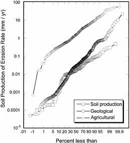
FIGURE 1.1 Comparison of natural erosion rates (over geological time) to agricultural soil erosion rates in relation to rates of soil production. The graph line comprising squares shows the rates of natural soil production, the circles show natural geological erosion, and the top line of diamonds shows agricultural erosion far exceeding the other two rates. SOURCE: Montgomery (2007a).
practical and scientific reasons why we need to better understand the impacts of humans on Earth’s physical environment.
ROLE OF THE GEOGRAPHICAL SCIENCES
Because natural processes vary spatially and across scales, a geographical perspective is essential to understanding their nature and character. The perspectives and tools of the geographical sciences used by geographers, geologists, ecologists, and others provide insights into soil erosion, flood magnitude and frequency, and ecological adjustments to climate change on both contemporary and paleotimescales. One significant area of investigation focuses on watershed response to and recovery from environmental changes, including Quaternary (past 2-3 million years) climatic changes and historical human-induced landscape changes. For example, because river systems respond to the integrative effects of climate and watershed processes, changes in streamflow, channel properties, and fluvial deposits provide information on the timing, direction, and magnitude of postglacial climate changes, suggesting that even modest climate shifts can generate significant changes in streamflow (Knox, 1993). Analyses of fluvial stratigraphic records have proved to be important because the identification of paleoflood occurrence extends the researchable time frame of these low-frequency events well beyond the stream gauge record, thus improving flood forecasting (Enzel et al., 1993; Baker, 1998) and capturing the periodicity of highly variable climatic episodes such as El Niño events (Gomez et al., 2004; Magilligan et al., 2008). These paleorecords suggest that climatic stationarity (the mean and variance of a time series) has not remained constant over time (Milly et al., 2008), which raises questions about existing water allocation arrangements because the stationarity assumption is the cornerstone of dam design and water allocation strategies. Higher resolution and longer-term datasets, such as those that can come from dendrochronology, can help capture these statistical shifts.
The geographical sciences have contributed to our understanding of floods as well, especially in relation to land-use changes. The massive construction of dams over the past several hundred years has had a profound impact on the hydrological regime (Figure 1.2), often leading to hydrological modifications exceeding the impacts of climate change (Magilligan et al., 2003; Magilligan and Nislow, 2005). Using archival national data, Graf (1999) identified more than 80,000 dams that have been constructed in the United States—essentially 1 dam per day on average since the signing of the Declaration of Independence. Graf ’s examination of the geographical location and context of these dams showed marked regional variations in dam number and type; most of the dams in the United States are in the eastern half of the country, although dams with the greatest impact on storage are found in the West (Graf, 1999, 2001). This pattern suggests that, although watershed fragmentation may be considerable in the eastern United States, ecological impacts due to flow reductions may be more significant in the western part of the country. Other field-based studies have provided fundamental insights into the profound
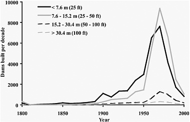
FIGURE 1.2 Number of dams constructed in the United States over the past 200 years (by decade) categorized by dam height. SOURCE: Doyle et al. (2003).
and sustained changes resulting from flow regulation, including changes in channel properties, sediment transport, and reduced ecological habitat (Chin et al. 2002; Phillips et al., 2005).
Because of their concern with spatiotemporal dynamics, geographical scientists have been at the forefront of efforts to use paleoenvironmental data to provide long proxy records of climatic and environmental change. Through techniques such as fossil pollen analysis, fossil charcoal analysis, tree-ring analysis, diatom analysis, chironomid analysis, and various sedimentological and geochemical techniques, geographical scientists have been able to reconstruct changes in terrestrial and aquatic environments on timescales ranging from decades to millennia. Such reconstructions can identify the specific nature of human impacts in the past, provide insight into the natural variability in environmental systems prior to human alteration, and show how environments have responded to past episodes of climate change. They can also be used to validate climate models used for estimating future climate change scenarios (Figure 1.3). In addition to providing qualitative and quantitative information on past environments, paleontological approaches are increasingly being refined and used to provide quantitative records of past temperature, precipitation, drought severity, and river flow (Cook et al., 2007). These records provide the only means of identifying the processes creating climatic variability and determining when anthropogenic climate changes have exceeded natural variability (Diffenbaugh et al., 2006; Herweijer et al., 2006; MacDonald et al., 2008b).
The integrated and synthetic research that is a hallmark of the geographical sciences is essential to address one of the major challenges in climate-change research: determining the natural (as opposed to human) contribution to climatic variability. Many paleoclimatic records and long instrumental data series provide evidence of variations in temperature that persist for decades to centuries. This natural variability in the climate system has two important implications for anticipating the impacts of global warming from increased greenhouse gases. First, if we do not understand their causes and properties, natural variations in climate make it difficult to detect or attribute current and future changes in climate to anthropogenic factors such as increased greenhouse gases. Second, such natural variations are likely to persist even in the face of greenhouse gas–induced climate changes and should be taken into account when planning for climate change. Often the relationships between the ultimate climatic forcing factors are mediated by complex relationships between the atmosphere, oceans, and land surface that play out differently from place to place (Feddema et al., 2005).
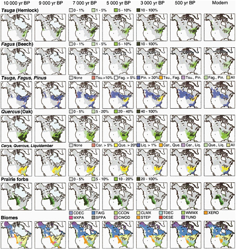
FIGURE 1.3 A mapped summary of changes in plant taxa distributions and biome distributions over the past 10,000 years based on sites in the North American Pollen Data Base. NOTES: CCON = cool conifer forest, CDEC = cold deciduous forest, CLMX = cool mixed forest, CWOD = conifer woodland, DESE = desert, MXPA = mixed parkland, SPPA = spruce parkland, STEP = steppe, TAIG = taiga, TDEC = temperate deciduous forest, TUND = tundra, WMMX = warm mixed forest, XERO = xerophytic scrub. SOURCE: Williams et al. (2004).
The synthesis of different measures of climate change over long temporal scales and across space is required to link particular forcing factors to climatic variations. The following questions are examples of research that would be particularly productive to pursue as part of the effort to refine understanding of the impacts of humans on the biophysical environment. Examples from the fluvial sciences are used to illustrate the importance of the research, largely because watershed processes are major landscape-forming agents. However, applications in the coastal, aeolian, hillslope, weathering, and glacial sciences also represent important avenues for research.
RESEARCH SUBQUESTIONS
What are the natural rates of Earth’s surface processes and how has human activity affected them?
Human activity has altered terrestrial, aquatic, and marine ecosystems, and these effects exceed natural baseline conditions. Although progress has been made in determining natural rates of earth-surface processes relative to anthropogenic effects, more research is needed across a suite of processes and regions, with greater attention paid to theoretically informed, empirically grounded assessments of the causes and consequences of anthropogenic disturbance. Anthropogenic impacts have been profound across a suite of earth-surface processes. The significance and scope of these impacts is evident in fluvial systems, for example. Yet erosion and transport rates of sediments stored within watersheds are still poorly understood, as is the residence time of these sediments. Moreover, sediments stored in floodplains represent a vast but currently unknown reservoir of material. These sediments are often contaminated with agricultural pesticides and herbicides. If stored for an adequate time, the toxicity of these contaminants attenuates, but if released by subsequent channel erosion, they may lead to progressive degradation of biotic habitats and contribute to degraded water quality, especially if resulting sediment concentrations exceed Environmental Protection Agency water quality standards for turbidity.
The renewed focus on landscape evolution requires accurate measures of erosion and sediment yield and necessitates studies to determine what component of the total contemporary sediment yield can be attributed to the human imprint. The application of contemporary measured sediment yields to these long-term studies may lead to unknown errors in calculating long-term (geological time) landscape erosion rates. On more contemporary timescales, the recent application of fallout radionuclides, such as 7Be, 137Cs, and 210Pb, has led to greater understanding of erosion and sedimentation rates and their spatial variability (Walling et al., 1999; Kaste et al., 2006), but more studies are needed over larger spatial scales to more accurately link processes of erosion to sedimentation and contaminant sequestration.
Equally important, more refined geographical analysis of hydrological responses to climate and environmental change can provide insight into the variable contributions of nature and humans to earth-surface changes. Climate models generally agree that wet areas will become progressively wetter (IPCC, 2007), but it remains uncertain how that atmospheric shift will translate hydrologically. Fluvial theory suggests that the magnitude and frequency of floods will increase as the climate gets wetter, but the impacts may be more complex, including changes in the timing of floods and the relative shift in the relationship between sediment peaks and streamflow. Previous research on paleofloods provides important insights into fluvial responses to climate change. Research in this vein is spatially incomplete, however, with most of the work restricted to the United States and Western Europe (Baker, 2008). More studies are needed globally, and past flood chronologies need greater temporal calibration and resolution. Recent advances in dating techniques, including optically stimulated luminescence (OSL), can help in this task, because they allow for more accurate dating of paleofloods, especially in regions where 14C dating is limited, such as in deserts or in situations exceeding the temporal bounds of 14C dating (~50 ka).
How can we best plan for and implement landscape restorations when disturbed areas are constantly influenced by human activity?
Few places on Earth remain unaffected by human activity. As anthropogenic disturbances have increased in magnitude and areal coverage during the past century, there has been a corresponding increase in efforts to mitigate their impacts. Hydrological systems, for example, have been especially affected by human activity, ultimately leading to demands for remediation; however, the science of watershed restoration lags far behind the need for, and application of, mitigation strategies (Wohl et al., 2005). Management strategies range from complete preservation and removal of direct human impacts to attempts to restore and rehabilitate some element of biophysical functioning and ecological integrity. Potential approaches may be constrained by legal and socioeconomic limitations, but also by not having an accurate understanding of biophysical processes, relaxation times, and the scientific metrics of successful restoration.
Because of extensive channelization, damming, and other structural modifications, most rivers—both in the United States and globally—are ecologically impaired, resulting in a wide range of impacts including habitat loss and fragmentation, interruptions in the hydrological regime, and changes in water quality and temperature (Stanford and Ward, 1993, 2001; Poff et al., 1997; Magilligan et al., 2003). To combat this degradation, efforts are under way to restore everything from small tributaries to rivers as large as the Rhine and ecosystems as vast as the Everglades. Management agencies such as the U.S. Forest Service and the Nature Conservancy are demanding the implementation of “environmental flows” that capture predisturbance conditions, but these goals may not be attainable given existing stakeholder demands and sociopolitical realities. Moreover, unknown complexities exist where, for example, establishing a flow regime to meet hydrological connectivity may have repercussions on sedimentation and aquatic habitat (Kondolf and Wilcock, 1996). More research needs to be directed at determining the correct magnitude and timing of flows to accommodate management goals within a context of humanized landscapes where complete restoration is impractical and where it is difficult or impossible to assess the precise character of a system not disturbed by humans. There needs to be better development of process-based restoration efforts (Kondolf et al., 2006; Doyle et al., 2007; Simon et al., 2007). In some instances, though, river restoration cannot be fully achieved because of social and technical limitations; hence there is a growing focus on river rehabilitation aimed at reestablishing fundamental riverine processes (Wohl et al., 2005). Successful restoration and rehabilitation efforts typically require collaborative research teams of geographers, ecologists, and other scientists conducting long-term field experiments and manipulations to assess the best possible restoration outcomes.
The coming decades will require greater attention to sediment impacts associated with changing environmental conditions. For example, with more than 500 dams removed thus far in the United States and many more targeted for removal in the relatively near future, there is a pressing need to advance understanding of the impacts of sediment fluxes as stream channels reestablish new equilibrium profiles. Moreover, the release of stored sediment has unknown ecological impacts. As dam removal is increasingly recommended as a panacea for habitat restoration, it is important to consider whether the release of stored sediment, in some instances, may be harmful to ecosystem functioning (Stanley and Doyle, 2002; Sethi et al., 2004; Snyder et al., 2004). The focus on sediment dynamics will require more sophisticated approaches, including numerical modeling, parameter estimation, flume studies, and field-based empirical approaches. Novel tracing studies are emerging to document sediment fluxes and residence times, including single-grain OSL, geochemical tracers such as 7Be and 210Pb, and active (radio) and passive (iron, magnetic) tracers (Schmidt and Ergenzinger, 1992; DeLong and Arnold, 2007; Salant et al., 2007). These approaches need refinement and broader application across a continuum of depositional environments. And studies that focus on the role of geographical context in producing detected stream-channel adjustments offer tremendous potential across the geosciences.
What tools offer particular promise in the effort to detect and measure changes in earth-surface processes, and how might those tools be deployed to enhance understanding of the impacts of humans on Earth’s physical environment?
Advances in remote sensing and geographic information systems have radically transformed the physical sciences, providing innovative opportunities to measure, analyze, and visualize geographical data and to raise and answer important new research questions (see Chapter 10). The magnitude and scale of environmental change makes it imperative that we utilize these new technologies to document global change, and to develop appropriate mitigation and adaptation strategies. Remote sensing technologies have enormous potential to facilitate the identification of regions at risk and to assess the magnitude and types of environmental changes that are occurring. They are also critical to the development of early warning systems. Moreover, some of the most far-reaching future environmental changes are likely to occur in regions lacking adequate data or long-term databases (e.g., eastern Africa, southwestern Asia, and the polar regions) (IPCC, 2007)—making the application of remote sensing in these areas all the more important (Box 1.1). Remote sensing analysis has
already proved beneficial in documenting the recent shrinking of subtropical highland glaciers (Coudrain et al., 2005), but more detailed, longer-term remote sensing can expand our understanding further. Similarly, remote sensing is capturing the widespread fragmentation of tropical forests (Morton et al., 2006), yet longer term geographical records are needed, as are remote sensing studies and on-the-ground surveys that can synthesize and analyze the integrated physical and biological effects of deforestation on human and biological communities.
One of the most significant recent advances in remote sensing is lidar (light detection and ranging), which provides very high resolution topographic data (Figure 1.4). Lidar systems transmit pulses of visible or near-infrared laser light from an aircraft to the surface. By measuring the time it takes for the pulses to be reflected, the elevation of the surface can be calculated. Because the costs are relatively high, most lidar missions cover only relatively small areas, and many regions have not yet been mapped. Nonetheless, the centimeter-scale resolution of lidar offers enormous opportunities in the physical sciences, especially in documenting global sea-level change, erosion and uplift of mountain ranges, agricultural soil erosion, glacial retreat, and postflood stream-channel changes. When multiple lidar returns are recorded for each location, the data can be used both to map the topography of the ground surface and to infer characteristics of vegetation, such as tree height (Andersen et al., 2006).
Other remote sensing sources of topographic information also exist. Interferometric radar has been used to map broader areas at coarser spatial resolution than lidar systems, as demonstrated in the February 2000 Shuttle Radar Topography Mission, which mapped 80 percent of the world’s land surface during an 11-day
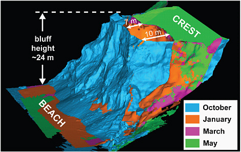
FIGURE 1.4 A high-resolution lidar image of a coastal bluff south of San Francisco, California, showing erosion over a 6-month period. The majority of bluff loss occurred in the fall (blue), with smaller sections of the bluff eroding in the spring (orange and pink) for a total horizontal loss at the top of the bluff of 7-10 meters (23-33 feet). Lidar also allowed the total volume of the eroded bluff material to be calculated, a key component in the development of an accurate sediment budget for this section of coastline. Such lidar-derived information is valuable to coastal managers interested both in the timing and magnitude of coastal erosion events and understanding where material lost from eroding bluffs is likely to accumulate. This information can guide development decisions adjacent to the bluffs, but was not commonly available prior to the development of lidar. SOURCE: Brian Collins, U.S. Geological Survey, 2004.
period. When interferometric radar data are collected at multiple points in time, differential interferometric analysis can be used to measure centimeter-scale changes in topography over broad areas, such as those resulting from seismic activity along faults, ground subsidence due to groundwater or oil extraction, and changes in glaciers and ice sheets (Kwok and Fahnestock, 1996; Bürgmann et al., 2000). Although interferometric radar provides coarser resolution than lidar systems, its global coverage from satellite platforms is currently more temporally and spatially extensive, and it shows exceptional promise for many applications in the physical sciences.
There are several areas in watershed science that could benefit from remote sensing applications. The U.S. Geological Survey operates a dense network of stream gauges in the United States, yet there is a paucity of gauges globally and thus large parts of the world lack adequate data on streamflow. With the application of SAR (synthetic aperture radar) and MODIS (Moderate Resolution Imaging Spectroradiometer)—two satellites gathering remote sensing data—it is becoming increasingly possible to measure streamflow (Smith, 1997; Brakenridge et al., 1998, 2007) and sediment load (Gomez et al., 1995) from satellites. Other promising approaches include mapping of stream-channel habitat using hyperspectral imagery (Marcus et al., 2003; Marcus and Fonstad, 2008) and integrating meteorological data and watershed response (Smith et al., 2007). Although launched for mapping gravity anomalies and crustal characteristics, one of the important extensions from the GRACE (Gravity Recovery and Climate Experiment ) satellite has been the documentation of groundwater levels from space (Strassberg, et al. 2009). Destined to be launched in 2013 (NRC, 2007a), the SWOT (Surface Water Ocean Topography) satellite mission offers enormous potential to monitor global-scale hydrological changes and map surface-water elevations. These rapid and remote techniques have great potential for the geographical study of fluvial systems. The utilization and incorporation of remote sensing into a range of investigations of hydrological and ecological phenomena offer researchers opportunities for collaborative and interdisciplinary studies (Walsh et al., 2003) that can lead to more spatially explicit, and therefore more useful, models of biophysical processes.
SUMMARY
As the foregoing examples make clear, spatial analysis, field-based research, geographical visualization, and fine-grained contextual studies are critical to assessing the magnitude and types of global biophysical adjustments that are presently occurring. The approaches and techniques of the geographical sciences can help identify and quantify the biophysical changes unfolding on Earth’s surface, and they can offer insights into the processes shaping those changes at different scales. Geographical science approaches and techniques thus have an important role to play in advancing scientific understanding of biophysical changes and facilitating the efforts of resource managers and policy makers to confront Earth’s changing environment.


