
3
How Are Climate and Other Environmental Changes Affecting the Vulnerabilities of Coupled Human–Environment Systems?
The biophysical changes unfolding across Earth’s surface are of increasing concern. Yet earth systems have always been changing and life has survived many environmental perturbations, a reflection of both biological adaptation and human ingenuity. It is thus important to view current biophysical changes not so much as raising issues of survival, as of creating differential vulnerabilities. Which life-forms are likely to be most exposed to, and negatively affected by, environmental changes? Are there significant socioeconomic changes unfolding alongside environmental changes that could leave some people or ecosystems with much greater exposure to risk? In such cases, will vulnerabilities associated with socioeconomic changes likely amplify or attenuate the impacts of environmental changes? Do some people or environments cope better with the impacts of changing circumstances than others?
The preceding questions treat people and their proximate biophysical environments as a unit—a coupled human–environment system (Turner et al., 2003b)—rather than as separate systems (cf. NRC, 1992).1 Such questions are geographical because the vulnerability of coupled human–environment systems—and, by extension their resilience (e.g., Berkes et al., 2002) or sustainability (e.g., Kates et al., 2001)—is a function of geographical differences in exposure, sensitivity, and adaptive capacity (Smit et al., 1999; McCarthy et al., 2001; Turner et al., 2003a; Gallopin, 2006). A fundamental concern of vulnerability, resilience, sustainability, and adaptation studies is to understand the conditions under which some places may be harmed by a given environmental change, even as others emerge relatively unharmed or in a better position to withstand repeated events in the future.2
Consider the Hurricane Katrina example discussed in Part I of this report. Geographical questions about vulnerability are critical to understanding what happened and to reducing associated risks in the future: Which people were, and were not, exposed to the breached levees and associated rising water levels, and why? Were all neighborhoods near breached levees equally sensitive to the rising water (e.g., did some of the exposed neighborhoods experience lesser physical and financial impacts than other exposed neighborhoods)? Of the exposed and sensitive places, which groups and individuals were able to adapt, restore their previous livelihoods, and/or reduce exposures and sensitivities to future storms? Raising and answering such questions is critical if some of the mistakes made leading to and in the aftermath of Hurricane Katrina are to be avoided in the future (Kates et al., 2006).
Understanding vulnerabilities associated with discrete events such as Katrina can illuminate more general vulnerabilities and associated adaptation options and constraints that are tied to long-term changes in climate. Climate change is expected to produce changes in patterns of precipitation and water availability (Figure 3.1), but it is unclear what vulnerabilities these changes may produce without first assessing how sensitive local populations are to such changes, and how effectively people may respond to the impacts of the changes. It is also important not to focus so much attention on climate events that we lose sight of how coupled human–environment systems may be vulnerable to nonclimate stresses or perturbations. A variety of natural occurrences and social processes can increase the vulnerability of peoples and places, including tsunamis, earthquakes, droughts, toxic waste spills, nuclear contaminations, economic globalization, deforestation, and HIV/AIDS. Complicating matters further is the fact that these developments do not necessarily operate in isolation, and that some of them (e.g., economic globalization) present potential benefits as well as pitfalls.
ROLE OF THE GEOGRAPHICAL SCIENCES
Since the 1980s, global environmental change has emerged as an important research area in many academic disciplines. Geographical scientists have played major roles in a variety of international and interdisciplinary environmental-change initiatives, and have taken a leading role in bringing vulnerability issues to the fore. Their research draws on a rich tradition of geographical work concerned with how humans are transforming Earth (Marsh, 1864; Sauer, 1925; Thomas, 1956; Glacken, 1967; Turner et al., 1990a). The approach of the “Chicago School of environmental risks and hazards” has been particularly influential. The Chicago School is based on the pioneering work of Gilbert White (e.g., White, 1945), who sought to explain why, in early 20th century United States, aggregate flood-related damages were rising, not falling, despite expanded technological interventions aimed at reducing flood damage. To answer this question, White focused on people’s decisions, asking what informational or psychological limitations led people to approach environmental risks and hazards in a way
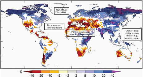
FIGURE 3.1 Global map of projected changes in annual runoff (water availability, in percent) for the period 2090-2099, relative to 1980-1999. Values represent the median of 12 climate models using the Special Report on Emissions A1B scenario. White areas are where less than 66 percent of the 12 models agree on the sign of change, and hatched areas are where more than 90 percent of the models agree on the sign of change. SOURCE: IPCC (2007).
that produced suboptimal outcomes (cf. Burton et al., 1978).
Several recent major global research initiatives have grown out of the Chicago School’s concern with the risk–hazards relationship, including sustainability science (e.g., Kates et al., 2001), socioecological resilience studies (e.g., Berkes and Folke, 1998), adaptation science (e.g., Smit et al., 1999), and coupled human–environment system vulnerability studies (e.g., McCarthy et al., 2001; Turner et al., 2003b). These four intersecting agendas define the core vulnerability-related research domains to which the geographical sciences are currently contributing. The contributions of the geographical sciences have focused particularly on understanding how people (and ecosystems) produce, and respond to, changing environmental conditions (e.g., Dow, 1992), and the social and political processes that produce differential exposures, sensitivities, and adaptive capacities, even in the absence of changing environmental conditions (e.g., Wisner et al., 2004).
A geographical perspective on vulnerability exhibits five basic features (Schröter et al., 2005). First, geographical studies of vulnerability situate the unit of analysis within the coupled human–environment system, rather than solely within the human or the environmental system. Accordingly, the methodological basis for these studies tends to be interdisciplinary, involving not only researchers from different academic backgrounds, but also stakeholders (i.e., those involved in making decisions about the processes under consideration). Second, the scale at which the coupled human–environment system is studied is generally “place-based,” meaning that local-scale human–environment processes and outcomes are emphasized—although not to the exclusion of processes and outcomes at other scales. Third, because the general unit of analysis is the coupled human–environment system, the drivers of system change are understood to be multiple and possibly interacting. Fourth, the analytical concern with exposures and sensitivities of multiple systems to multiple stressors at multiple scales means that central attention is given to the differential abilities of places to adapt to stresses. Finally, recognition of the dynamic nature of the interactions that shape coupled human–environment systems translates into a concern with shifting vulnerabilities across time (how vulnerabilities have changed in the past and what they might look like in the future). What unites these five characteristics of geographical vulnerability studies is that the particular interconnections among processes found in different places are privileged rather than assumed away.
Two recent studies illustrate what the geographical sciences bring to the study of vulnerability. In one study, Cutter and Finch (2008) analyze temporal and spatial changes in social vulnerability via the Social Vulnerability Index (SoVI), which measures the social vulnerability of U.S. counties to environmental hazards (originally introduced in Cutter et al., 2003). The SoVI is a score assigned to each unit of analysis (in this case, U.S. counties) derived from a principal components analysis of variables hypothesized to reflect various social vulnerabilities to natural hazards. Cutter and Finch draw on decennial U.S. Census data for the period 1960-2000, but their study is also forward looking. They examine trends in the historic data to project SoVI values for the year 2010, and they compare maps of SoVI scores for each past census year with the projected year (Figure 3.2). Future vulnerability studies of this sort could benefit from data at a finer spatial resolution (in some parts of the country, the county represents areas that are so large and populous as to mask important local variations), and from data reflecting the effects of multiple hazards in a given location. These types of data could be correlated with the SoVI; stakeholders could also be polled to comment on the utility and accuracy of the model results.
A second study by O’Brien et al. (2004) illustrates an approach to studying vulnerability that treats it as the product of multiple interacting stressors. Their case study looks at the interrelated vulnerability impacts of globalization and climate change in India (see also the discussion of this line of research as it relates to inequality, in Chapter 8). They collected secondary data reflecting multiple biophysical, social, economic-trade, and technological features of individual Indian districts, and analyzed the data using geographic information system (GIS) map algebra. This approach allowed them to produce a set of district-level maps of exposures, sensitivities, adaptive capacities, and vulnerabilities that highlighted districts that are doubly exposed to the negative impacts of globalization and climate change (see Figure 8.4). The authors further sampled three of these doubly exposed districts for further in-depth
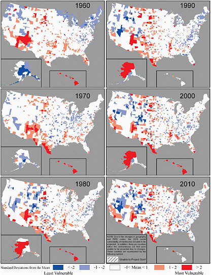
FIGURE 3.2 Maps from the Social Vulnerability Index (SoVI) illustrate the results of bringing the geographical science perspective to the study of vulnerability. SoVI scores are place-based because, by construction, a county’s SoVI score is only meaningful in relation to an entire set of county scores. When the scores are mapped, they illustrate the geographical variation in social vulnerability, and highlight potential uneven capacity for disaster preparedness and response. The scores can be used by both policy makers and practitioners to determine resource allocation for disaster preparedness. SOURCE: Cutter and Finch (2008).
local examination, using participatory rural appraisal techniques, including surveys and interviews. Future vulnerability studies could benefit from a sensitivity analysis to elucidate the relative importance of different stressors in producing vulnerability. Such studies should also consider how legal and administrative realities may be amplifying or attenuating the components of vulnerability.
As the foregoing examples suggest, the geographical sciences approach to vulnerability recognizes that
vulnerabilities are dynamic across space and time, and are most meaningfully examined at a local scale, provided larger-scale influences are not ignored. The geographical science approach to vulnerability engages not only expert scientists, but also other people who belong to and know intimately the peoples and places under study. Research advances are likely to come from investigations that both fill in gaps in our understanding of particular places and address questions of resilience, sustainability, and adaptation. The following illustrative subquestions provide examples of the types of research that would be particularly productive to pursue.
RESEARCH SUBQUESTIONS
How will climate change affect patterns of vulnerability and resilience in rapidly urbanizing areas?
Human land uses and land-use changes are implicated in global environmental change and resulting patterns of vulnerability (Turner et al., 1990b; Rindfuss et al., 2004; Foley et al., 2005). Yet the precise links between land-change processes and vulnerability are not well understood (Turner et al., 2005, 2007). Most land-change research has underemphasized one or more of the five criteria for vulnerability assessments outlined above, and has focused on a specific type of land change (typically forest conversion for harvesting, agricultural, ranching, and/or settlement purposes) in a specific type of setting (often tropical or subtropical locations) (e.g., Moran et al., 1994; Rudel, 2005). The extraordinary growth of cities in the contemporary era, however, points to the need for land-change research using a vulnerability approach in rapidly urbanizing locations.
Coastal zones are important sites for research because many of them are urbanizing rapidly and will likely face impacts from climate change (Chapter 4). Will rapid urbanization render coastal ecosystems particularly vulnerable to the effects of sea-level rise and tropical storms in the 21st century? How will people’s culturally driven preferences for certain types of urban vegetation, such as turfgrass, affect urban coastal ecosystems? Most important, how will these coupled human–environment systems respond and adapt to shifting exposures and impacts? Efforts to address these types of questions can build on recent geographical research linking urbanization and environmental change in different settings. Researchers in Phoenix, Boston, New York, and Baltimore have examined, in parallel efforts, the spatial relationships among changing urban land uses and land covers and a variety of human–environment outcomes (Guhathakurta and Gober, 2007; Kirshen et al., 2008; Boone et al., 2009; see also, e.g., Law et al., 2004; Rosenzweig et al., 2005; Ruth et al., 2006).3 These research projects, which are diverse in methodological approach, could be expanded through a coordinated effort to examine the human–environment impacts of land-use and land-cover changes under different climate change scenarios, and by focusing not only on physical outcomes, but on social response options and constraints.
The extent to which urbanizing areas in general, and urbanizing coastal zones in particular, will be vulnerable to the effects of climate change will depend not only on the range of technological and policy options, but also on the feasibility of implementing those options. Feasibility is, of course, a function of cost, but cost is not the only constraint. Political, social, and cultural barriers and opportunities may also be important in the decision-making calculus. To identify the presence or importance of such opportunities and constraints, research needs to be undertaken that is aligned with the needs of decision makers—both individual citizens and people in positions of authority (e.g., infrastructure managers, elected officials). The prospects for such alignments grow when the science is coproduced with the potential end users of the research—an undertaking that is not simple and usually requires a sustained relationship-building effort among the different constituencies (White et al., 2008; Gober et al., In Press).
The conceptual frameworks, theoretical bases, and methodological approaches employed in tropical land-change research may need to be adapted for use in examining the land-change–vulnerability link in urbanizing zones.4 Data are needed that can facilitate
analysis of the interconnected impacts of urbanization and climate change on local hydrological flows, nutrient concentrations, flora and fauna, and human health. In urbanizing coastal zones, research is also needed on land-change–vulnerabilty links, including studies of estuarine eutrophication and associated impacts on marine-related livelihoods (e.g., fishing, tourism) and assessments of the prospects for different mitigation strategies (e.g., of reducing nitrogen inputs into streams). A key overarching concern should be the trade-offs that people are likely to face in different places as environmentally destabilizing climate change becomes more acute.
Answers to these questions can advance scientific understanding and address management and policy needs. Effective decisions require data on the full suite of human and environmental variables implicated in these human–environment processes: household-level data on individual characteristics, attitudes, and behaviors; community-level data on general governance structures and specific land and resource management policies; and state-level data on economy and society. Using GIS, for example, social variables can be examined spatially alongside environmental variables (e.g., land cover, climate, hydrology, topography). The types of research teams needed to collect and analyze such data are similar to those participating in several past, current, and future interdisciplinary research programs supported by the National Science Foundation, the U.S. Forest Service, and NASA, such as Coupled Natural-Human Systems, Decision Making Under Uncertainty, Human and Social Dynamics, Long-Term Ecological Research, Urban Long-Term Research Areas, and Research Opportunities in Space and Earth Sciences. Like the work being done under the aegis of those programs, the tools and techniques of the geographical sciences are essential to the task of integrating the data that need to be analyzed across space and in particular places.
How can we better measure and integrate the impacts of processes operating at different scales on vulnerability and resilience?
As noted in Part I, scale is a bedrock geographical concept. Geographical scientists have shown that the relationships observed at one scale do not necessarily mirror those observed at other scales. This idea is well established in general terms (Meyer et al., 1992; Bian and Walsh, 1993; Easterling, 1997; see also, e.g., Moellering and Tobler, 1972; Openshaw and Taylor, 1979; O’Neill, 1988; Root and Schneider, 1995), and particularly in the land-change literature (e.g., Geoghegan et al., 1998; Lawrence et al., 2005). Yet to date, there have been few vulnerability studies in which multiple, nested scales are analyzed simultaneously (cf. O’Brien et al., 2004, for an exception). Moreover, there have been no systematic attempts to pool existing vulnerability results from varying scales to produce generalizations about scale dependencies, a challenge discussed in the next illustrative subquestion. For example, for the municipality of New Orleans, were Katrina-related vulnerabilities at the household level significantly associated with municipal-level land-use policies? If so, were these relationships more important in certain neighborhoods than others?
To advance understanding of cross-scale vulnerability dynamics, two historical obstacles need to be confronted: (1) the lack of availability and high cost of high-spatial-resolution data and (2) inadequate resources for processing those data (see discussion in Part III). For vulnerability studies requiring land-cover information, assessing household-level processes has been limited by the spatial resolution of satellite imagery, often with pixels that are 30 m on a side (i.e., 900-m2 areas). This level of resolution does not allow direct statements to be made about individual household-level processes and outcomes when, as is common, multiple households are collocated within a given 900-m2 area. For those cases where high-resolution data have been available and affordable, the resources required to process the data—for broad geographical extents—has represented another research obstacle. Processing high-resolution aerial photographs (i.e., <1 m) has been prohibitively expensive, even for municipal-scale studies.
In recent years, however, the costs of very high resolution imagery (i.e., with pixels <1 m) and the software required to process such imagery quickly have declined, and this trend is likely to continue. These cost reductions make it easier for researchers to use high-spatial-resolution data to examine processes and outcomes at multiple scales simultaneously. In the coming decade, our understanding of cross-scalar dynamics can be greatly enhanced if geographical scientists develop a
series of municipal-level vulnerability studies that draw from high-resolution environmental datasets that can capture the scale of the household. In this way, households need not be sampled from a given municipality, and a more representative picture can emerge of both household- and municipal-level processes.
Of course, remote sensing data represent only a subset of the potentially necessary data for the study of coupled human–environment system vulnerability and resilience. Other means of data collection and analysis (e.g., interviews, surveys, focus groups, participant observation) have proved valuable as well. Such methods can be effective for making observations about exposures, sensitivities, and adaptive capacities, at multiple scales. Indeed, the data generated by such approaches are often rich in information about cross-scale interactions, and can shed light on how the outcomes that are observable at one scale are associated with factors at other scales. Developing methods for assessing these cross-scale interactions would advance our understanding of the challenges faced by coupled human–environment systems. Building on past vulnerability studies that use a variety of data collection and analysis methods, and on geographical technologies that identify or estimate the variable impacts of multiple processes in individual places, the geographical sciences are well positioned to test the long-held geographical hypothesis that “scale matters” in the vulnerability domain.
How can studies of vulnerability and resilience on qualitatively different topics be compared to make valid broader generalizations about vulnerability?
Vulnerability and resilience assessments are wide-ranging. Some studies have examined agricultural dynamics in developing countries, whereas others have focused on urbanization challenges in Western Europe. The topical diversity of studies makes it difficult to draw comparisons and make generalizations from independent study results. To move forward, research is needed that can facilitate efforts to specify the general conditions under which coupled human–environment systems become vulnerable to the effects of human–environmental changes, document and assess the geographical patterns of these vulnerabilities, and analyze why such patterns emerge. If this challenge is not taken up, the vulnerability concept could evolve into an appealing idea with limited applied scientific value beyond providing spatially and temporally contingent findings from a set of noncomparable case studies.
It follows that a major research need for the coming decade is to inventory the existing vulnerability and resilience literature, and to determine whether the studies can be compared using a meta-analytic framework for the purposes of drawing broad conclusions about vulnerability—even when the data and the methods used to collect and analyze the data differ. There is a well-developed meta-analysis literature in the social sciences, specifying how to pool results from independent studies into a larger dataset that permits more powerful inferences and generalizations. Meta-analysis is most helpful and easiest when the predictor and outcome variables are similarly defined and measured. For example, medical studies of the effects of smoking on human health can be readily pooled because a person’s smoking behavior and health are variables that lend themselves well to common definitions and measurements.
Extending classical meta-analytic techniques would be useful in the case of vulnerability, where the definitions and measurements of variables are often not comparable across studies. Geographical scientists have contributed to an allied effort in recent years, attempting to draw systematic comparisons across studies of tropical deforestation that look at different variables and employ diverse methods. Notable examples of such meta-analyses include Geist and Lambin (2002), Misselhorn (2005), and Rudel (2005). None of these applications, which use techniques such as qualitative comparative analysis (QCA; Ragin, 1987), address vulnerability as such, but they hold promise for vulnerability research. Research is needed to demonstrate whether a creative blending of techniques and methods (e.g., coupling QCA with the vulnerability scoping diagram [Polsky et al., 2007]) can facilitate the production of vulnerability meta-analyses. Geographical scientists are well positioned to contribute to this undertaking. They could pool results from the emerging body of knowledge on, for example, the land-use-policy/ coastal-storm vulnerability relationship in the New Orleans area and test the applicability of the common themes that have emerged in that domain to other coastal-zone metropolitan areas exposed to similar environmental hazards (e.g., Miami, Houston).
SUMMARY
The geographical sciences recognize that vulnerabilities are dynamic across space and time. Opportunities to expand our understanding of the changing patterns of vulnerability in response to environmental change are most likely to come through research focused on underexamined contexts and through research that looks for patterns and processes across geographical spaces and scales. Advances in our understanding are most likely to be achieved through investigations that examine issues of resilience, sustainability, and adaptation at local scales, and their relationships to larger scale processes.


