
Introduction
On August 29, 2005, Hurricane Katrina struck the city of New Orleans, Louisiana, and adjacent coastal areas. Strong winds and intense rain raced up the Mississippi River Delta with the eye of the storm immediately east of New Orleans over Lake Pontchartrain (Figure 1). Westward wind rotation forced the surface of the lake toward the city. The massive pulse of energy and water, albeit not extreme by historical hurricane standards, resulted in the failure of multiple levees, which in turn overwhelmed pumping capabilities and produced widespread flooding. The devastation included some 1,500 deaths, $40-50 billion in physical damages, and the largest forced migration of residents in U.S. history, with approximately 410,000 evacuees still scattered across the country as of October 2006 (Groen and Polivka, 2008).
The meteorological and engineering components of the Katrina disaster help us appreciate what happened. Yet bringing the analytical strengths of the geographical sciences to bear on the storm—situating it in the context of a set of evolving human and environmental circumstances near and far—is essential to understanding the larger causes and consequences of Katrina and to making effective plans for future disasters. The perspective adopted by the geographical sciences involves four dimensions.
First, the Katrina disaster was not an environmental event so much as it was a human–environment event. If the storm had encountered a differently organized landscape, then the impacts might have been less severe. A land-use planning process rooted in the geographical sciences would have produced a pre-Katrina New Orleans with a more extensive deltaic and wetlands buffer, with stronger levees and pumping systems, and with more robust evacuation plans for all neighborhoods. In short, coupled physical and human
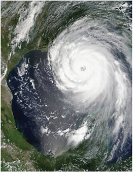
FIGURE 1 Image of Hurricane Katrina on August 28, 2005, from the Moderate Resolution Imaging Spectroradiometer (MODIS) aboard the National Aeronautics and Space Administration (NASA) Terra satellite. SOURCE: Jeff Schmaltz, MODIS Rapid Response Team, NASA Goddard Space Flight Center.
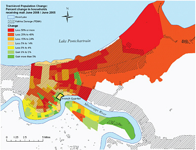
FIGURE 2 The percentage change in the number of households receiving mail from June 2005 to June 2008 in New Orleans Census tracts gives an estimate of changes in population, showing a complex spatial pattern of population gain and loss. SOURCE: American Communities Project, Brown University; mail receipt data from U.S. Postal Service, damage data from the Federal Emergency Management Agency.
processes,1 rather than simply the physical storm itself, made the Katrina disaster what it was.
Second, the storm’s impacts were not evenly distributed, but instead exhibited important spatial variations and patterns. Although many of the damaged New Orleans neighborhoods near Lake Pontchartrain have lost 25-50 percent or more of their pre-Katrina populations (Figure 2), other neighborhoods in the same area have registered much lower population losses, while some neighborhoods have even experienced population growth since the storm. Explaining such spatial variations and patterns requires understanding how past decisions and practices, including possible socioeconomic or racial biases, affected different places (e.g., Did policy differences between neighborhoods produce different impacts within the city of New Orleans? Why have some neighborhoods gained population since the storm?). A better understanding of such spatial relationships could help residents and decision makers anticipate and mitigate the human toll from the next storm.
Third, the processes that led to the Katrina disaster operated at multiple and interlocking geographical scales, meaning that processes that led to the outcomes were operating at different scales, with each process possibly affecting the others. Mapping Katrina’s impacts at different geographical extents and resolutions highlights the potential for added insights when the same outcome is viewed at different scales. A Gulf Coast–scale map of county-level population change from 2005 (before the storm) to 2007 shows broad but nuanced patterns of post-Katrina population movement (Figure 3). In this map the localized pockets of modest population loss, and population gain, manifest in Figure 2 are not evident. By contrast, the regional view may provide insights that the finer-scale picture cannot provide, such as the areas where some of the displaced Gulf Coast residents may have moved—namely, areas north and west of the damaged areas. A geographical sci-
ence perspective would use this pair of maps to ask questions such as the following: Were the locations of population gain the product of Katrina out-migration, or of in-migration by people previously not resident in the region? What state-level policies, if any, were responsible for this pattern of population shifts, and did those policies and their effects vary by state? Did the emergency response effort by the Federal Emergency Management Agency contribute to some of the patterns apparent from the maps?
Fourth, understanding Katrina and the processes that led to its dramatic and yet uneven impacts requires integrating spatial and temporal analyses. Even though the historical context of urban development in New Orleans was responsible for some of the spatial variations in who was most adversely affected by Katrina and what areas were most able to recover quickly, there are other, less spatially and temporally proximate, contributing factors. Also responsible was a long-term commitment to agricultural development in the Mississippi River basin, which has involved massive hydroengineering projects and activities (e.g., dredging/channeling, damming, straightening, levee building), and agricultural reclamation policies, which together have contributed to significant loss of protective wetlands in the delta area by altering the natural sediment regime over hundreds of miles of one of the world’s greatest rivers. Looking to the future, a better understanding of hurricane patterns over time in the Atlantic Ocean and the Gulf of Mexico can provide insight into how and why hurricanes happen, and help construct improved climate models that can facilitate planning for future storms like Katrina. Such forward-looking research is particularly important given the possible impacts of anthropogenic climate change, sea-level rise, and changing land-use patterns on the Mississippi River, its delta, and the Greater New Orleans region.
Geographical scientists use a suite of approaches and tools (e.g., mapping, geographic information systems [GIS], remote sensing, spatial statistics, modeling, deductive analysis drawing on sociospatial data) to provide insight into the forces that produce events such as Hurricane Katrina and to understand their
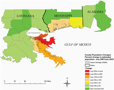
FIGURE 3 Mapping population changes for counties along a swath of the Gulf Coast illustrates broader spatial patterns of movement. This pattern influenced and was influenced by processes operating at multiple scales, such as the local, state, and regional (i.e., Mississippi Basin). SOURCE: American Communities Project, Brown University; population data from U.S. Census Bureau, damage data from the Federal Emergency Management Agency.
|
BOX 1 Geographical Science in Action During Hurricane Katrina Geographical scientists played an important role in the response to Hurricane Katrina. Geographical scientists from Louisiana State University occupied the GIS desk in Louisiana’s emergency operations center (EOC), mapping 911 calls, making recommendations for the best places to locate shelters, and processing imagery to show flood extent. One geographical scientist helped create the map that became the primary visualization used by the EOC to understand situation awareness—a Google Earth mashupa showing the flood extent on top of a three-dimensional image of New Orleans. Geographical scientists also used Google Earth to identify possible landing zones close to health facilities for search-and-rescue helicopter pilots and helped coordinate responses among agencies. In addition, they accompanied Red Cross Disaster Assessment Teams in the field, helping them understand and map residential changes in the wake of the hurricane. |
consequences for the Gulf Coast and beyond (see Box 1). The core concepts, methods, and tools of the geographical sciences are essential not only for assessing what happened, but also for asking what will become of New Orleans and surrounding areas, for evaluating alternative redevelopment scenarios, and for developing designs that will prevent a similar-scale disaster in the future.
EMPIRICAL AND METHODOLOGICAL APPROACHES OF THE GEOGRAPHICAL SCIENCES
Drawing upon the four core concepts described through the example of Hurricane Katrina, empirical work in the geographical sciences focuses on documenting, analyzing, and explaining (1) the location, organization, and character of physical and human phenomena on the surface of Earth and (2) the interplay of arrangements and processes, near and far, human and environmental, that shape the evolving character of places, regions, and ecosystems. These concerns, which have long been central to the discipline of geography, have recently been taken up by researchers in a range of disciplines who are interested in how the geographical configuration and interaction of different phenomena shape the evolution of places, environments, and societies. To cite only a few examples, spatial econometrics has emerged as a major subfield of economics, environmental studies programs with a focus on human impacts on the environment have sprung up in universities and research institutes across the country, a Spatial Pattern Analysis Program for Categorical Maps (FRAGSTATS) is increasingly used in ecological research, and geographical technologies2 have come to play a central role in fields ranging from epidemiology to archeology.
The rapid growth of the geographical sciences over the past two decades is a reflection of both technological developments and changing research priorities. On the technological side, modern remote sensing systems have greatly enhanced the ability of the scientific community to access increasingly high-resolution, near real-time data on the operations of human and biophysical systems.3 At the same time, a quartet of technologies—GIS, Global Positioning Systems (GPS), remote sensing, and geospatial visualization—have facilitated the processing, analysis, and representation of geographical data. It is only a modest exaggeration to say that these technologies are revolutionizing everything from the workplace to everyday life—with profound implications for information management, governance, commerce, and travel.
On the research front, growing concern about human alteration of the environment, the impacts of globalization, and resource depletion has fostered a great deal of scientific interest in climate change, land-cover change, watershed restoration, sustainability, migration, and global inequality. All of these matters raise fundamentally geographical questions. How are human and environmental systems linked,
and to what effect? How do phenomena and process vary across the surface of Earth? How do developments at particular scales reflect and shape processes at other scales? How are systems evolving across space and time? These questions require researchers to wrestle with geographical concepts, and the new geographical technologies described above are often of great use in efforts to address them.
The effort to confront the foregoing questions has given rise to robust transdisciplinary research communities focused on coupled human–environment systems. It has also fostered a powerful conceptual engagement with spatial thinking—a constructive amalgam of concepts of space, tools of representation, and processes of reasoning (NRC, 2006). These developments make clear that the geographical sciences are about much more than simply mapping phenomena and describing variance across places. They are instead rooted in a concern with the interaction of phenomena and systems that were long treated as distinct (e.g., human and natural systems); an interest in investigating how spatial variance can help refine general theories or models, rather than simply being treated as something to be held constant; and a recognition that explaining patterns and processes on Earth’s surface requires consideration of how they have evolved through time and are shaped by developments at different scales. In pursuit of such concerns, much research in the geographical sciences involves some combination of the following methodological approaches: collection, analysis, and visualization of spatially explicit data; investigation of the relationship between large-scale processes and local or regional outcomes; and landscape analysis.
Collection, Analysis, and Visualization of Spatial Data
Efforts to record, analyze, and display spatial information are central to much work in the geographical sciences. Maps showing the changing distribution of diseases point to environmental factors that can make people sick (e.g., Jacquez and Greiling, 2003), historical reconstructions of plant distributions allow environmental scientists to assess and refine climate models (e.g., Whitlock and Bartlein, 1997), and reconstructions of trade patterns and commodity chains show how socioeconomic circumstances produce economic change (e.g., Dicken, 2007). Dramatic changes have occurred over the centuries in the way Earth’s surface is understood and mapped. Today, the struggles to find an accurate means of measuring longitude (Sobel, 1995) are of merely historical interest as the GPS has reduced the measurement of location to an almost trivial exercise (except when extreme accuracy is required). Yet the importance of identifying and analyzing patterns has been fundamental to human understanding through the ages—allowing geographical thinkers in Ancient Greece to calculate the circumference of the Earth and those in the modern world to refine understandings of the causes and consequences of urban growth.
The importance of the technological innovations of recent decades lies in their ability to facilitate the collection and analysis of locational information, and to make it possible to produce sophisticated geographical visualizations that can aid scientific understanding and public decision making (Figure 4). These same technologies can be employed to create improved or optimized designs of a wide range of geographically distributed features and facilities, from voting districts to schools, shopping centers, and mass transit routes. Indeed, the geographical sciences have a long history of being employed not only to analyze the world but also to improve it, and there are many strong links with the disciplines of planning, landscape architecture, operations research, and engineering in general. The term geodesign has recently emerged as a useful umbrella for the use of geographical data and tools in support of design.4 Moreover, the geographical sciences hold the key to a vision of planning that is based more on sound evidence than on judgment. Tools such as GIS can be used to subject designs to rigorous analysis based on established and well-tested scientific knowledge, by simulating the effects of known environmental and social processes. For example, options for new transportation infrastructure can be assessed against known patterns of human spatial behavior, and options for new buildings can be assessed against models of heat loss based on sound principles of atmospheric science.
|
4 |
See, e.g., www.geodesignsummit.com (accessed January 28, 2010). |
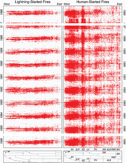
FIGURE 4 Patrick Bartlein and his colleagues’ geographical visualization provides insight into where and when different fires occur in the western United States. Building on a visualization technique developed by a Scandinavian climatologist (Hovmöller), their representation shows that lightning-started fires are temporally clustered (the streaks of fire show that widespread outbreaks occur over a few days, and take place earlier in the West than farther east). In contrast, human-set fires show distinct clustering in space that reflects where people live in the West. Because the distribution of fires is spatially uneven, these sorts of insights cannot be gained from conventional fire maps. SOURCE: Bartlein et al. (2008).
Whether enabled by new technologies or not, the collection, analysis, and representation of spatial data are of central importance to the geographical sciences because they promote understanding of how phenomena are related to one another in particular places and across the surface of the Earth.
Investigation of the Relationship Between Large-Scale Processes and Local or Regional Outcomes
A central feature of the geographical sciences is the recognition that circumstances existing at the local or regional scale both affect and reflect larger-scale processes. Much work in the geographical sciences thus proceeds from the idea that there is a great deal to be learned from analyzing “place-based” circumstances and their relationship to larger-scale processes (Massey, 2005). This approach differs from other sciences where research aims to produce generalizations that require averaging across places (thus relegating differences among places to the background). The geographical sciences, by contrast, frequently focus on the circumstances and comparative characteristics of individual places and regions, and then seek to develop broader generalizations by exploring what is general and what is particular about the processes observed in those places (see, e.g., Abler, 2003). Taking such an approach to the Katrina example cited above, for example, involves looking at similarities and differences among places—politically bounded or otherwise—where the processes shaping the impacts of Katrina (state policy decisions, landscape features, upstream land uses, etc.) come together in distinctive ways. Those place-based differences can then be used to assess and refine general models and concepts.
Place-based analysis has long been important in geographical studies (e.g., Cliff and Ord, 1973; Anselin, 1995; Fotheringham et al., 2002), but its significance is increasingly being recognized in other scientific realms, especially ecology, and it has become a core feature of the emerging field of sustainability science (Kates et al., 2001). Place-based approaches have also recently emerged as a key strategic direction of the Obama administration. In an open memorandum dated August 11, 2009, senior White House staff directed the heads of executive departments and agencies to develop effective place-based policies in their preparations for the FY 2011 budget (Orszag et al., 2009). The memorandum includes language that resonates with many of the themes and principles on which the study committee based its work, and which are elaborated in many parts of this report; for example, the memorandum’s section defining place-based policy notes that such “policies target the prosperity, equity, sustainability and livability of places—how well or how poorly they function as places and how they change over time.”
Landscape Analysis
Investigation of the tangible human and physical features of Earth’s surface that exist in particular places is another common feature of geographical investigation. Landscapes are expressions of the processes and events that shape places over time; as such, they offer clues into what has happened and where and why it has happened (Conzen, 2010). Detailed studies of land-use and land-cover change in different regions have shown that population growth and poverty cannot alone explain the changing landscape; economic opportunities and institutional factors need to be considered as well (Lambin et al., 2001). Similarly, studies of continuity and change in urban landscapes have provided insights into the social, cultural, and institutional forces that are shaping the evolution of human communities (Wyly, 1999). Studies of the material landscape are important to the geographical sciences because they offer information and ideas of fundamental importance to the effort to explain the physical and human forces that are shaping Earth’s surface over time.
The core concepts and approaches of the geographical sciences have spread across many scientific disciplines and into the everyday practices of business and government; they are now routinely employed by archaeologists, economists, astrophysicists, epidemiologists, biologists, landscape architects, computer scientists, and others (Box 2). They are thus not solely the province of the traditional discipline of geography. Instead, the relationship between geography and the geographical sciences can be understood by using a biological metaphor. The geographical sciences are the result of a successful propagation of the graft of data, technologies, and ways of thinking onto the root stock of geography. The latter continues to be a place where central attention is given to the concepts and tools employed by the geographical sciences, but those concepts and tools have now diffused beyond the formal discipline. The recent decision to change the name of the “Geography and Regional Science”
|
BOX 2 Spotlight on the Geographical Sciences In 2008, economist and New York Times columnist Paul Krugman received the Nobel Prize in Economics for his analysis of trade patterns and location of economic activity.a Krugman won the prize for a mathematical model that helped explain regional disparities. His general equilibrium model focused on the interaction of economies of scale with transportation costs, which provided insights into the spatial consequences of increasing returns. His model formalized and placed within the parameters of the general equilibrium model prior understandings of the economic advantages to be gained from the spatial agglomeration of production and the ways in which such agglomeration contributes to regional disparity, as well as to interregional trade. His work has given rise to what is sometimes termed a “new economic geography” among international trade theorists, who traditionally adopted a neoclassical economics approach to understanding agglomeration (Behrens and Robert-Nicoud, 2009).
|
program at the U.S. National Science Foundation to the “Geography and Spatial Sciences” program reflects the growing transdisciplinary character of geographical research and analysis. The new program represents an explicit acknowledgment of the cross-disciplinary communities that are now dealing with spatial ideas, data, and techniques.
THE GEOGRAPHICAL SCIENCES AND SOCIETY
The importance of the geographical sciences in the 21st century becomes clear when one considers the extent to which many of the central challenges of our time are tied to changes unfolding in the spatial organization and character of the peoples, places, landscapes, and environments found on the surface of the planet. Earth has always been dynamic—constantly in flux as physical systems and human societies evolve (Turner et al., 1990a). Yet the pace and extent of human-induced changes have reached unprecedented levels in recent decades. Massive numbers of people are on the move; cities are mushrooming in size (Figure 5); ecosystems are being transformed; patterns of economic, social, and political activity are being remade; access to resources and markets are changing; and technological developments are altering patterns of connectivity among peoples and places (Figure 6). With geographical changes so central to the contemporary scene, geographical analysis is necessarily fundamental to contemporary science.
Because of its multidisciplinary character, research in the geographical sciences lends itself to multi-investigator projects, which are becoming increasingly common. The explosive growth in geographical data and technologies can facilitate collaborative projects across vast distances, as researchers tap into shared data banks and make use of virtual systems. The diffusion of information and communication technology has also led to a democratization of science that puts anyone with access to a computer terminal and the Internet in the position of being able to collect and disseminate
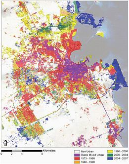
FIGURE 5 This map of urban growth in Doha, Qatar, from 1973 to 2007 illustrates the trend of increasing urbanization occurring in mid-size cities around the world. SOURCE: Karen Seto, used with permission.
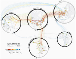
FIGURE 6 This map shows key intercontinental and regional Internet routes and their bandwidth. Disparities in available Internet bandwidth contribute to the differences in access to information and communication technologies that have come to be known as the “digital divide.” SOURCE: TeleGeography.
information. Geographical platforms such as Microsoft Virtual Earth and Google Earth are at the forefront of this development. These developments heighten the importance of geographical investigation—both to harness the flood of new geographical information in productive ways and to explore the possibilities and limitations of the information and ideas coming from the rapidly expanding community of “neogeographers” (nonspecialists involved in the collection and assessment of locational data using geographical platforms and technologies). Moreover, when geographical techniques that allow for the precise, systematic monitoring of phenomena are used to collect information on people’s activities, complex issues of privacy arise that demand careful consideration by researchers who possess a significant understanding of the nature and power of the geographical technologies involved.
The geographical sciences are also well positioned to strengthen ties between the science and policy-making communities—an increasingly pressing matter as the need grows to respond quickly to the outbreak of disease, manage natural resources in better ways, and improve understanding of complex issues such as inequality and global climate change. Maps and other geographical visualizations are becoming increasingly powerful decision-support tools for the policy sector (Richardson and Solis, 2004). Because geographical visualizations can render complex data in an understandable form, including data about phenomena that change over time (Figures 7 and 8), policy makers are able to see the concrete implications of different choices. Moreover, the concern of the geographical sciences with the relationships among different phenomena, including the physical and human world, put them in a strong position to enrich policy debates by broadening the frame of reference of the matters being considered (Bebbington, 2004;
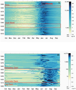
FIGURE 7 Raster hydrographs show average daily discharge (cfs) as a color for each of the 33,969 days of record for Yellowstone River at Corwin Springs, MT (upper) and the 36,529 days of record at the Snake River near Moran, WY (lower). The raster hydrographs enable visualization of daily to seasonal variations within a year by noting changes across each row, and variations between years and decades for a given time of year along the vertical axis. Key events such as the Dust Bowl drought, the low flows prior to and during the Yellowstone fires of 1988, and dam closures are shown. The Yellowstone River has no dams, so flow variations are generally gradual. In contrast, the closure of Jackson Dam on the Snake River led to many abrupt changes in daily discharge. Diagrams such as this make it easier for the general public, managers, and scientists to understand the different timescales over which variations occur.
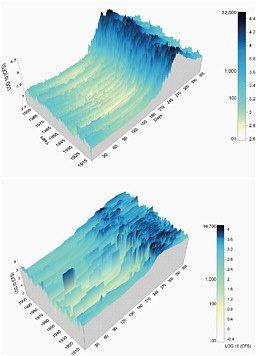
FIGURE 8 Three-dimensional raster hydrographs show the difference in flow regime between a river with no dams (above) and a dammed river where the natural flow regime is significantly modified (lower). Three-dimensional diagrams of this sort make it easier for the general public to visualize and understand how humans affect the river environment. SOURCE: Strandhagen et al. (2006).
Gober, 2004), directing attention to linkages that are of interest to a variety of stakeholders (White et al., 2008), and helping policy makers understand—and factor into their recommendations—the irreducible uncertainties that must be considered when confronting complex, large-scale issues such as climate change (Gober et al., 2009).
COMMITTEE APPROACH
The massive, rapid changes unfolding on Earth’s surface provide a logical starting point for considering strategic directions for the geographical sciences, for there is clearly a pressing need to understand what is changing where, why, and at what rate, as well as to assess the implications of those changes for different places and regions. The time is ripe for a consideration of how, and in what ways, the deployment of the concepts, tools, and approaches of the geographical sciences can be particularly strategic in the coming years. With these matters in mind, the National Science Foundation, the U.S. Geological Survey, the National Geographic Society, and the Association of American Geographers requested that the NRC appoint a committee charged with developing a report that would identify strategic directions for the geographical sciences in the coming decade (Box 3).
The committee used the following criteria in selecting questions that would signal strategic directions for the geographical sciences:
-
The questions must have clear societal significance.
-
The questions must be central to the core concepts of the geographical sciences.
-
The questions must relate clearly to the agendas of the larger scientific community.
-
The questions must be tractable (i.e., there must be a strong likelihood of achieving significant and demonstrable progress in the next 5-10 years).
-
The questions must be answerable using either existing methods and sources of data or methods and data sources that can reasonably be expected to be readily available within the next few years.
Employing these criteria, and drawing on input from the larger community of geographical scientists, the committee developed 11 questions that represent some of the most important opportunities for the geographical sciences to contribute to the task of understanding
|
BOX 3 Statement of Task An ad hoc committee will formulate a short list of high-priority research questions in the geographical sciences that are relevant to societal needs. The questions will be written in a clear, compelling way and will be supported by text and figures that summarize research progress to date and outline future challenges. |
and responding to the changes that are currently having such a profound impact on the planet (Part II). The committee also spent time discussing what changes in infrastructure, training, and outreach would allow the geographical sciences to make progress toward answering the 11 questions (Part III).
The Process of Identifying Research Questions
The research questions in Part II of this report came out of a committee effort to consider the major scientific and societal questions of the day related to changes unfolding on Earth’s surface, and then to identify some of the key ways in which the geographical sciences can contribute to addressing those issues. There is, of course, much debate about what qualifies as a major scientific and societal question, but committee discussions identified four (necessarily overlapping) arenas of inquiry that are widely recognized as being of broad significance: (1) how to understand and respond to environmental change, (2) how to promote sustainability, (3) how to recognize and cope with the rapid spatial reorganization of economy and society, and (4) how to leverage technological change for the betterment of society and the environment. The research questions that lie at the heart of this report were chosen because they raise issues of central importance to these arenas of inquiry that the geographical sciences are particularly well positioned to address.
Understanding and responding to environmental change can be greatly enhanced by bringing a geographical perspective to bear on several key questions:
-
How are we changing the physical environment of Earth’s surface?
-
How can we best preserve biological diversity and protect endangered ecosystems?
-
How are climate and other environmental changes affecting the vulnerabilities of coupled human–environment systems?
Promoting sustainability requires addressing questions that probe the geographical dimensions of population change, resource scarcity, and health:
-
How and where will 10 billion people live?
-
How will we sustainably feed everyone in the coming decade and beyond?
-
How does where people live affect their health?
Assessing the impacts of economic and social reorganization can be advanced by raising questions about the changing human geography of the planet:
-
How is the movement of people, goods, and ideas transforming the world?
-
How is economic globalization affecting inequality?
-
How are geopolitical shifts influencing peace and stability?
Making technological change work for the betterment of society and the environment demands consideration of questions about the collection and representation of geographical information:
-
How might we better observe, analyze, and visualize a changing world?
-
What are the societal implications of citizen mapping and mapping citizens?
In broad terms, the contributions the geographical sciences can make to science and society lie in their potential to improve understanding of the extent and causes of the changes unfolding on Earth’s surface, to offer insights into the impacts of those changes, to promote the development of effective adaptation and mitigation strategies in response to those changes, and to facilitate the documentation and representation of Earth’s evolving geographical character. The foregoing research questions are strategic because they speak, in overlapping ways, to these contributions. Looking at changes in the physical environment, settlement and mobility patterns, economic and political arrangements, and the collection and representation of spatial data are all critical to understanding the extent and causes of the changes unfolding on Earth’s surface. Assessing the impacts of those changes requires looking at the impacts of shifting environmental and resource vulnerabilities and evolving demographic, economic, and social patterns. Developing effective adaptation and mitigation strategies necessitates improved understandings, and better visual representations, of changing environmental and social
patterns and threats to human health and well-being. Finally, assessments of the potential and limitations of new technologies and new ways of collecting data are needed to improve the documentation and representation of geographical change.
The individual research questions do not encompass the full range of issues amenable to geographical investigation, but they represent critically important scientific and societal matters to which the geographical sciences have much to contribute. The order in which they are presented reflects a movement from overarching issues of environmental change and sustainability to matters that bear on particular changes unfolding in the social and technological arenas. This order is not intended to suggest that the earlier questions are more important than the later, however, or that the questions should necessarily be addressed in the order presented. Indeed, there is considerable overlap among and between the questions, and the last question is of relevance to all of the preceding questions.
Part II of this report sets forth each of the research questions, identifies prior work in the geographical sciences of relevance to the question, and outlines particularly promising avenues for advancing understanding of the question. Because the overarching questions are broad, each one is followed by a set of illustrative sub-questions that are indicative of more focused research initiatives that could contribute substantially to the effort to address the larger question. The report then turns to Part III, which considers the innovations that will be needed in infrastructure, training, and outreach if significant progress is to be made in addressing the research questions.


