
3
Measuring Fluxes from Land-Use Sources and Sinks
The agriculture, forestry, and other land-use (AFOLU) sector is the second-largest emitter of greenhouse gases, but the single greatest source of uncertainty. Uncertainty in carbon dioxide (CO2), methane (CH4), and nitrous oxide (N2O) emitted by AFOLU activities is typically 50-100 percent or more. Much of the uncertainty associated with total AFOLU emissions is caused by uncertainty in measurements of carbon stocks associated with deforestation and rates of tropical forest cover change. For example, the standing biomass of tropical forests is uncertain by a factor of 2 (Houghton et al., 2001; Saatchi et al., 2007), and estimates of the annual flux of CO2 released through forest clearing are uncertain by the same amount (Houghton, 2003; Achard et al., 2004; DeFries et al., 2007). For this reason, it is useful to focus on trends in AFOLU activity levels, rather than on the emissions themselves. For example, if the annually deforested area in a country decreases by a factor of 2, then, all else equal, CO2 emissions from deforestation have also decreased by a factor of 2 (van der Werf et al., 2009a).
This chapter first describes remote sensing methods that are able to estimate the activities responsible for the majority of AFOLU emissions (e.g., deforestation) and removals by sinks. It then identifies research that the United States could undertake to reduce uncertainty in these estimates. Such methodological improvements are periodically incorporated into United Nations Framework Convention on Climate Change (UNFCCC) inventory methods developed by the Intergovernmental Panel on Climate Change (IPCC). The chapter concludes with a discussion of research that could lead to long-term improvements in remote sensing capabilities.
REMOTE SENSING
Remote sensing provides a means to survey vegetation and land surface properties over large areas. It can be used to estimate the area within each country of recently harvested forest, mature forest, pasture, and various kinds of cropland, including rice paddies, which are a dominant source of CH4 emissions. It is also an effective means to measure fire and logging, which do not always lead immediately to detectable changes in forest cover. Time-series analysis of multiple scenes can be used to detect changes arising from deforestation, forest degradation, and afforestation. Deforestation refers to the conversion of forestland to agricultural cropland, grassland, and settlements. Degradation refers to a decrease in carbon stocks of ecosystems (e.g., through selective harvesting, draining of peatlands, or burning). Afforestation is the conversion of other land categories to forest.
In general, the transition from forest to cropland, urban areas, or pasture emits CO2 because of the decomposition of woody debris and short-lived wood products and because the remaining material is often burned to facilitate conversion. After clearing, forests can remain an annual net source of CO2 to the atmosphere for 5 to 20 years, with shorter time frames in warmer and wetter climates (Luyssaert et al., 2008) and in areas where the conversion process is rapid and
more complete (Morton et al., 2008; van der Werf et al., 2009b). In contrast, afforestation causes a small long-term CO2 sink because woody biomass and soil organic matter build up slowly on the site for decades to centuries. Forested land that is harvested (e.g., forest degradation) and then allowed to regenerate produces a large and short-lived CO2 source, followed by a small and long-lived CO2 sink.
Uncertainty of AFOLU Activities, Emissions, and Removals by Sinks
Table 3.1 summarizes the current levels of uncertainty for estimates of forest area, carbon stocks, and AFOLU emissions by remote sensing and the improvements in accuracy that could be accomplished using remote sensing and ground monitoring within several years. The most important messages in the table are the following:
-
The area of land that is deforested within a country can currently be assessed with an uncertainty of less than 50 percent over a period of 5 years (e.g., Hansen et al., 2008), but this could be improved to 10-25 percent annually by expanding efforts to analyze satellite imagery.
-
Uncertainty in remote sensing-based estimates of annual carbon fluxes from deforestation, reforestation, and forest degradation is now high (25-100 percent), but could be reduced to 10-25 percent by integrating remote sensing observations with new ground observations of forest biomass and peatland soil organic matter and biogeochemical models for spatial estimates.
-
The area of flooded soils that emit CH4 (rice, wetlands) can be determined each year with a relatively low uncertainty (~10 percent), although uncertainty in emissions is high (50-100 percent). Ground survey data on specific management practices would provide the greatest reduction in uncertainty.
-
Uncertainty in annual N2O emissions from managed soils is high (about 50 percent) for the best current inventory methods, and even higher (>100 percent) for developing countries. More flux measurements for different nitrogen management practices and agronomic systems, coupled with improvements in process-based models, would be the most effective action to reduce uncertainties. More information on trends in fertilizer consumption would provide insight about changing emissions when combined with information on management practices, crop production, and weather.
The next five sections describe the methods and studies behind these conclusions.
Available Satellites and Classification Methods
Although a variety of satellite and aircraft sensors have been used to map land cover and land use (e.g., see Table 3.2), Landsat is widely used and offers several advantages for regional- and country-level greenhouse gas inventory applications. First, the pixel resolution (30 m) is high enough to distinguish most plant cover characteristics, while providing a sufficiently large area of coverage per scene to allow regular global coverage to be practical. Second, the 16-day repeat cycle allows the seasonal information needed for classification purposes, such as greening and browning of grasslands, to be obtained in areas with little or no cloud cover. Third, Landsat data provide a time series of observations beginning in 1984, although the older data have some significant spatial gaps. A global map of land cover in 1990, when coverage is most complete, could serve as a baseline from which to identify subsequent changes (see Figure 3.1 for a Landsat map of the United States using data from the early to mid-1990s).
Forests can be distinguished from nonforests at accuracies of 80-95 percent using Landsat-type imagery (Table 3.1; Lu et al., 2007; GOFC-GOLD, 2008). Accuracies can be validated with in situ observations or very high resolution aircraft or satellite data at a statistically defensible subsample of locations (e.g., systematic or stratified sampling using Ikonos satellite data). The accuracy of remote sensing-derived land cover maps can be assessed in a number of ways, including comparisons with independent data collected in ground surveys. Errors are divided into those due to omission (exclusion of an area from a category in which it belongs) and commission (inclusion of an area in a category to which it does not belong), and categorized by land cover class and region. All approaches are based on statistical sampling. Land cover change also includes errors in geolocation and other factors.
TABLE 3.1 Reducing Uncertainties of Greenhouse Gas Emissions from Land Use Through Remote Sensing and Improved Monitoring Systems
|
Measurement |
Current Annual Uncertaintya |
Nature of Improvement |
Recommendationb |
Attainable Annual Uncertainty |
Notes |
|
Forest Area |
|
|
|
|
|
|
Northern forest area |
1c |
Systematic land cover mapping across different countries using multiple satellite data streams |
A |
1+ |
|
|
Northern forest deforestation afforestation |
2-3d |
Long-term continuity of ~30 m and ~1 m satellite observations; new investment to map changes at an annual scale using new change detection algorithms |
B, A |
1-2 |
Loss of LDCM would increase uncertainty for both northern and tropical deforestation rates to level 5 (greater than 100%) |
|
Tropical forest area |
1-3e |
Same needs as for mapping northern forest area; improved access to international satellite observations |
B, A |
1-2 |
|
|
Tropical forest deforestation-afforestation |
3-4f |
Same as above |
B, A, C |
1-2 |
|
|
Carbon Stocks |
|
|
|
|
|
|
Northern ecosystem carbon stocks |
2-4g |
Improved access to existing country inventories; a new initiative to improve the spatial distribution of emission factors by combining P-band radar and lidar observations with inventory data |
E, D, C |
2 |
Many Annex I forest carbon inventories are not publicly available |
|
Tropical ecosystem carbon stocks |
3-4h |
Capacity building for tropical forest and peatland inventories; the emission factor initiative described above |
E, D, C |
2 |
Forest biomass measurements have not been systematically organized; peatland areas and depths have not been accurately mapped |
|
Ecosystem Degradation |
|
|
|
|
|
|
Logging |
3-4i |
Dedicated high-resolution (~1 m) observations for assessing logging rates in deforestation hot spots and for relating degradation patterns to Landsat observations; a wood products tracking system |
B, A |
2 |
|
|
Fire emissions from tropical forests and peatlands |
3-4j |
Improved atmospheric emission ratios of CO/CO2 for deforestation and peatland fires |
E, F |
2 |
An OCO rebuild with existing MOPITT and TES CO observations would enable improved estimates of peat emissions |
|
CO2Emissions |
|
|
|
|
|
|
Northern ecosystem carbon fluxes |
2-4k |
Improved inventories with below ground carbon monitoring in cropland, grassland, and forests; integration of improved observations with biogeochemical models |
A-E |
2 |
Higher uncertainty levels for countries without inventories |
|
Measurement |
Current Annual Uncertaintya |
Nature of Improvement |
Recommendationb |
Attainable Annual Uncertainty |
Notes |
|
Tropical ecosystem carbon fluxes |
4-5l |
Improved estimates of forest cover change, emission factors, measurement inventories including post-clearing land uses, and top down constraints from column CO2 satellite measurements; integration of improved observations with biogeochemical models |
A-F |
2 |
|
|
CH4Emissions |
|
|
|
|
|
|
Rice production area |
2-3m |
Multisensor mapping (e.g., Landsat, Ikonos, SAR) |
A, C |
1 |
|
|
Flooded rice area |
3n |
Multisensor mapping (e.g., SMAP, SSM/I, Landsat) |
A |
1 |
|
|
Soil CH4 emissions |
3-4o |
Ground surveys of management practices; flux measurements as a function of key management practices, including midseason drainage and fertilizer application |
E |
2 |
|
|
Fire CH4 emissions |
4-5p |
Continuous sampling instruments established on towers near fires and used to calibrate models and remote sensing data in relatively homogeneous areas |
E, F |
3 |
|
|
N2O Emissions |
|
|
|
|
|
|
Soil N2O emissions |
4-5q |
Flux measurement network targeting different hot spots and soil, fertilizer, and manure management practices |
E |
3 |
|
|
NOTES: CO = carbon monoxide; LDCM = Landsat Data Continuity Mission; MOPITT = Measurements of Pollution in the Troposphere; OCO = Orbiting Carbon Observatory; SAR = synthetic aperture radar; SMAP = Soil Moisture Active-Passive; SSM/I = Special Sensor Microwave Imager; TES = Tropospheric Emission Spectrometer. aUncertainty levels are 1 = <10%; 2 = 10-25%; 3 = 25-50%; 4 = 50-100%; and 5 = >100%. bRecommended improvements: A. A new U.S. initiative to map global land cover and land-use change at an annual resolution using multiscale remote sensing data, including but not limited to the instruments listed in Table 3.2. A key part of this initiative is the design of multiscale approaches for ground truthing in rapidly changing areas, drawing on regional expertise from ground observers and high-resolution (~1 m) satellite and aircraft imagery. B. Successful launch and operation of the LDCM, together with immediate investment in follow-on missions for 30 m and 1 m resolution continuous data, which are crucial for monitoring logging and for improving emission factor estimates in hot-spot areas. C. Improved remote sensing data policies for sharing moderate- and high-resolution observations for forest cover and forest biomass monitoring (e.g., existing moderate-resolution visible and infrared reflectance measurements and radar observations from several countries cannot be downloaded for perusal or exploration by U.S. scientists). D. Improved data policies for sharing forest inventory observations among different countries. E. A new U.S. initiative to reduce uncertainties associated with emission factors related to land-use change and ecosystem degradation. This would include capacity building and investment in international scientific efforts to develop forest and peatland inventories in tropical countries, including carbon stocks associated with key post-clearing trajectories of land use. It would also involve a research program to find the most efficient ways to combine inventory observations with satellite observations (including existing P-band radar and lidar observations) to map spatial patterns of forest biomass and peatland carbon. For the fire component of forest and peatland degradation, new information of the emissions ratios of CO and CO2 from different types of tropical burning would enable more effective use of column CO2 and CO observations to constrain emissions. Emission factors for CH4 and N2O as a function of agronomic system and management practice (e.g., midseason drainage in rice agriculture) are not well characterized and represent a primary source of uncertainty in estimating regional scale emissions. F. Rebuilding and launching an Orbiting Carbon Observatory satellite to measure column CO2. Fire emissions at the deforestation frontier in South America and Southeast Asia would be detectable by an OCO-like instrument. An OCO rebuild would also help to constrain estimates of emissions from peatland degradation in Southeast Asia. cGOFC-GOLD (2008). |
|||||
|
dExpert opinion based on Landsat change detection approaches taken by Masek et al. (2008) and Kennedy et al. (2007). Masek et al. (2008) report for the conterminous United States that the rate of disturbance between 1990 and 2000 was 0.9 ± 0.2% per year, primarily as a consequence of harvesting and fire. eFor global humid tropical forest area, the difference between the Hansen et al. (2008) estimate for the year 2000 (1,152 Mha) and the Achard et al. (2002) estimate for the year 1997 (1,076 Mha) is relatively small (less than 10%). For tropical forest area as a whole (including forest area within 90 tropical countries), the 2005 Food and Agriculture Organization (FAO) Forest Resource Assessment estimate for the year 2000 is 1,828 Mha (Grainger, 2008). FAO assessments for this larger domain have varied considerably in different reports over the last three decades, particularly at the scale of individual countries (see Table S5 in Grainger, 2008). Estimates of year 2000 forest cover, for example, differed by more than 10% for 6 of the 12 countries with the largest amounts of tropical forest area (Grainger, 2008). fAssessments of tropical forest cover loss by Hansen et al. (2008) and the 2005 FAO Forest Resource Assessment differ by about a factor of 2 (5.4 Mha yr–1 vs. 12 Mha yr–1 for 2000-2005). Although part of this difference is associated with study domain; at a country level differences between the two approaches remain substantial, with a ~16% difference for Brazil between the two approaches and more than a factor of 2 difference for Indonesia (Hansen et al., 2008). gFor some northern regions, such as the coterminous United States, forest biomass mapping approaches—which combine remote sensing and detailed inventory information—appear to be converging (see Table 11.2 of CCSP, 2007, and Table 5 of Blackard et al., 2008), implying that the uncertainty range is currently within ±25%. In other temperate and boreal regions, where inventory information is not as complete, the uncertainties are higher (Houghton et al., 2009; Goodale et al., 2002). hRegional-scale inventories in tropical regions depend on both the quality of the inventory observations and the remote sensing techniques used to extend these observations in space and time. Based on differences between extrapolation approaches, uncertainties for aboveground live biomass within the Amazon basin are within ±50% (Houghton et al., 2001; Saatchi et al., 2007). Peatlands within the Indonesian Archipelago are extensive (Page et al., 2004) but have not been systematically mapped in terms of carbon content or depth. iFor the Brazilian Amazon, Asner et al. (2005) estimate wood extraction to range between 27 million and 50 million cubic meters of wood using Landsat observations to identify degraded areas. Detailed estimates using high-resolution satellite observations are not available for many other tropical countries. jVan der Werf et al. (2008) estimate emissions from Indonesia, Malaysia, and Papua New Guinea during 2000-2006 to be 128 ± 51 Tg C yr–1, with a large component of the uncertainty attributable to an incomplete characterization of emission factors (CO/CO2 ratios) for peat fires. kExpert opinion based on syntheses by Goodale et al. (2002) and CCSP (2007). lGlobal land-use change was estimated to be 1.2 ± 0.7 Pg C yr–1 for 2008 in Le Quéré et al. (2009), with uncertainties dominated by tropical forest areas. These uncertainty levels remain similar to those reported in Working Group 1 of the IPCC Fourth Assessment (Denman et al., 2007). mExpert opinion based on analysis of data on rough rice area and yield; available from the International Rice Research Institute at <www.irri.org/science/ricestat/index.asp>. nExpert opinion. Key factors influencing flooded area include water demand for other sectors and changing rice management practices (Frolking et al., 2004). Flooded areas can be detected using passive microwave satellite observations (Prigent et al., 2007). oExpert opinion based on studies by Wassmann et al. (1996), van der Gon (1999), Jain et al. (2000), and Li et al. (2002). pCampbell et al. (2007). qThe committee assumed that the –40% to 70% uncertainty range for global annual agricultural N2O emissions reported by Bouwman et al. (2002) was conservative and that uncertainties are likely to be considerably higher in many regions and individual countries where activities are not consistently measured. Key agricultural components that need to be sampled more effectively include manure generated from livestock management and different types of fertilizer application (e.g., Davidson, 2009). |
Longer sampling intervals (e.g., 5 to 10 years) lead to higher rates of omissions of land cover change because of forest regrowth after harvest. The uncertainty can be reduced in many cases by using scenes collected more frequently (e.g., <1 year to 2 years) in the analysis. A global analysis using the Global Land Survey Landsat data record has been produced at a decadal interval, and efforts are under way to reduce this to a 5-year interval at least back to 1990 (Townshend et al., 2008). The reduction from 10 to 5 years will reduce omissions of land cover change, although 2-year intervals are likely to be necessary in regions where vegetation regrows quickly (e.g., wet tropical forests).
Remote Sensing of Deforestation, Forest Degradation, and Afforestation
Deforestation and Afforestation. Large-scale contiguous forest clearing is easily observed with a variety of satellite sensors that provide frequent global coverage (>250 m resolution), although significant deforestation also occurs in smaller patches <100 m2 in size or in fine-scale linear patterns (Skole and Tucker, 1993). Landsat-type remote sensing (30 m resolution) can detect deforestation at fine scales (Huang et al., 2009). Nearly complete coverage of the globe from Landsat satellites is available for the early 1990s and 2000s. Lower resolution (1 km) Advanced Very High Resolution Radiometer (AVHRR) data on global land cover characteristics are available from 1992 to 1993.1
Deforestation by complete clearcut harvest or stand-replacing fire is currently being assessed with annual Landsat data in some regions (e.g., Oregon, California, Washington; Law et al., 2006; Kennedy et al., 2007). An accuracy assessment in Law et al. (2006)
|
1 |
See the Global Land Cover Characteristics database at <http://edc2.usgs.gov/glcc/>. |
TABLE 3.2 Current Land Remote Sensing Instruments in the Public Domain
|
Instrument |
Measurement |
Resolution and Coverage |
Data Availability |
|
Land Remote Sensing Satellite (Landsat) |
Provides the longest continuous record of the Earth’s continental surfaces |
15-60 m, global |
Landsat 7: 1999-present Landsat 5: 1984-present |
|
Advanced Spaceborne Thermal Emission and Reflection Radiometer (ASTER) |
Provides high-resolution images of the land surface, water, ice, and clouds |
15-90 m, global |
1999-present |
|
Moderate Resolution Imaging Spectrometer (MODIS) |
Measures biological and physical processes occurring on the surface of the Earth, in the oceans, and in the lower atmosphere |
250 m-1 km, global |
1999-present |
|
Airborne Visible/Infrared Imaging Spectrometer (AVIRIS) |
Measures constituents of the Earth’s surface and atmosphere |
5-20 m, aircraft is tasked |
1998-present |
showed an uncertainty of 20 percent when automated techniques were compared with air photos (Table 3.1). These methods may be suitable for countries with appropriate technical expertise and software capabilities for automation.
Forest Degradation. Remote sensing techniques can be used to identify partial biomass removals over large areas, particularly biofuels harvest (Asner et al., 2005) and selective harvest of high-grade trees in the tropics. In northern forests, degradation from logging can be
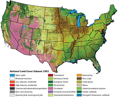
FIGURE 3.1 Major land cover features for the coterminous United States, based on early to mid-1990s Landsat Thematic Mapper satellite data. SOURCE: Vogelmann et al. (2001). Reprinted with permission from the American Society for Photogrammetry and Remote Sensing.
distinguished by inferring changes from the differences between two satellite images or, more recently, by examining as many as 25 images over a time series to identify segments that are changing over time. The former is typically done using annual to subannual Landsat data and research-level algorithms. The latter (trajectory-based image analysis), which is currently operational across the Pacific Northwest region of the United States, has advantages over traditional approaches in that it can detect forest thinning and trends such as progressive change from one land cover type to another, spreading mortality, and slow regrowth of forests over time (Kennedy et al., 2007). It can also detect a wide range of disturbance and recovery phenomena that were previously too ambiguous to label, capturing types of degradation with accuracies two to five times higher than previous change detection methods. Combining trajectory-based image analysis and high-resolution data improves the accuracy of regional estimates of terrestrial carbon fluxes and enables identification of the type of forest degradation (e.g., thinning versus mortality from insects or diseases; Kennedy et al., 2007). Such subtle disturbances may have potentially large cumulative impacts on carbon cycling at the regional scale (e.g., large-scale mortality of boreal forests from insect attack; Kurz et al., 2009).
Landsat data are also being used in time-series analysis across North America to identify forest areas subject to harvest and wildfire with a repeat interval of 2 years (Goward et al., 2008). An assessment over southeastern and northern U.S. national forests indicated overall accuracy values of 80 percent when comparing automated to human-identified disturbance mapping (Table 3.1). Most of the omissions were partial disturbances, such as thinning and storm damage, although some clearing harvests may not be detectable with temporal intervals of 2 years or more in areas of rapid forest regrowth (Huang et al., 2009). This type of approach has the potential to be applied globally.
Degradation from selective logging is more difficult to detect. In tropical forests, selective logging may leave a forest canopy that fills in within a year or that does not appear to have been thinned. The trajectory-based change detection approach has not been tested in the tropics. A new forest degradation monitoring system (Real-time Detection of Deforestation, DETER) has been developed in Brazil to detect selective logging, based on techniques of spectral mixture analysis and Normalized Difference Fraction Index (GOFC-GOLD, 2008). The system was tested in Brazil and Bolivia using 30 m Landsat data, and it failed to detect selective harvest. The system is now being tested using Satellite Pour l’Observation de la Terre (SPOT) 5 (10 m resolution) and ASTER (15 m resolution) imagery, which have spatial resolutions more appropriate for the size of individual tree canopies. Even if this approach is successful, it has three limitations: (1) it requires frequent (at least annual) mapping; (2) natural (e.g., windthrow) and human-caused degradation can be confused, possibly requiring additional ground or air photo interpretation; and (3) it requires a higher level of expertise and software for automated techniques.
At the national scale, the most effective method for detecting areas of selective harvest is to apply high spatial and temporal resolution remote sensing approaches to areas suspected of thinning, such as those determined by detection of landings along roads. Asner et al. (2005) applied an automated image analysis approach to annual Landsat data and pattern recognition techniques for detecting selective logging in the Brazilian Amazon. The analysis required initial ground-based spectroscopic characterization of surface features and tree species canopy spectra from a spaceborne hyperspectral sensor (Hyperion). The authors found an overall uncertainty of up to 14 percent in total logged area, based on seasonal Landsat data, atmospheric modeling, detection of forest canopy openings, surface debris, and bare soil exposed by forest disturbances. Alternatively, a combination of seasonal Landsat-type remote sensing and lidar or P-band radar may be required to reduce uncertainty (Treuhaft et al., 2004).
Anthropogenic fires in tropical peatlands and at the deforestation frontier contribute substantially to interannual variation in the growth rate of atmospheric CO2 and CH4, so fire monitoring is crucial to separate natural trends in atmospheric concentrations from the effects of mitigation. In addition, fire is used in some parts of the world to clear forest for pasture or agriculture, and fire is an important source of atmospheric CH4 (14-88 Tg CH4 yr–1; Mikaloff Fletcher et al., 2004; van der Werf et al., 2006; Denman et al., 2007). A variety of remote sensing methods are being used to identify the location, area, and intensity of fire. The Global Observations of Forest and Land Cover
Dynamics (GOFC-GOLD) project is working to develop a global system of geostationary monitoring of active fires. Multiyear burned area products derived from moderate resolution satellite imagery are available from several sources including SPOT (Tansey et al., 2008) and the Moderate Resolution Imaging Spectrometer (MODIS; Giglio et al., 2006; Roy et al., 2008). Landsat provides more accurate mapping of fire area and severity in forests and shrublands, and it has been used for this purpose in the United States since 1984.2 Tests using field data indicate that change detection using Landsat identifies high-severity fires with 10-30 percent uncertainty, moderate-severity fires with 40-50 percent uncertainty, and low-severity fires with 30 percent uncertainty in the western United States (Miller et al., 2009). In four fires in the western United States, low- and moderate-severity fire released 58 and 82 percent as much carbon emissions, respectively, as high-severity fire (Meigs et al., 2009), so determining the severity of all fires would reduce uncertainty in emissions estimates. National reporting is inconsistent, limiting our understanding of fire effects on forest and ecosystem degradation.
Approaches to estimating fire emissions vary widely and some result in overestimates because of faulty assumptions about the amount of fuel that is combusted (Wiedinmyer et al., 2006; Campbell et al., 2007). A common approach is to use Landsat (30 m pixels) estimates of burn area (change detection) and fire severity, and combustion completeness factors derived from field observations of live and dead biomass and surface organic matter before and after fire. Global-scale estimates use similar methods, but draw on moderate-resolution burned area observations (e.g., 500 m MODIS data) that do not differentiate fire severity. They require the use of models to estimate biomass and combustion completeness (e.g., van der Werf et al., 2006). An alternate method for global estimates is to use fire radiative power estimated at a subpixel level (e.g., using MODIS) and calibrated based on relationships between radiated energy and field estimates of combustion (Wooster et al., 2005). The results are at a coarser resolution than those yielded by the Landsat approach because active fire observations are currently available only at 1 km spatial resolution. The approach may be able to detect large homogeneous fires (27-34 percent uncertainty), but it is less effective in areas with high tree cover or heterogeneous burned areas (45 percent uncertainty; Hawbaker et al., 2008; Giglio et al., 2009). With both the regional and the global approaches described above, parameterizations of combustion completeness are now the most uncertain component of these models.
Post-fire emissions of CO2 can be substantial and may persist for several years after fire as a consequence of decomposition of remaining organic matter, including vegetation killed but not consumed by the fire (e.g., McMillan et al., 2008). Key factors that regulate the time it takes for an ecosystem to transition from a source to a sink after fire include the severity of the fire, recruitment and growth of new plant species within burned areas, and fire-induced changes in the microclimate, which influence rates of decomposition and levels of soil moisture.
Soil Carbon
Remote sensing of soil carbon stocks is not possible because the soil immediately below the surface is opaque to the portions of the electromagnetic spectrum used to detect properties of organic matter. Further, variations in soil moisture, soil mineralogy, plant residue, and vegetation cover make even soil surface carbon estimates problematic, although low- versus high-organic-matter soils can be broadly differentiated (Sullivan et al., 2005; Yadav and Malanson, 2007). However, remote sensing provides information on aboveground vegetation (e.g., plant phenology, leaf area, photosynthetically active radiation) and residue cover. In conjunction with models, these data can be useful in estimating soil carbon stocks and stock changes and greenhouse gas emissions. Nevertheless, a much more extensive set of ground-based soil carbon measurements will be necessary to improve the soil carbon models before they are reliable enough for treaty purposes (see below).
Cropland and Pastures
Most comprehensive maps of agricultural land cover derived from satellite imagery provide information only on aggregate classes (e.g., row crops) and often at relatively coarse (e.g., 1 km) resolution (Friedl
|
2 |
See <http://mtbs.gov/>. |
et al., 2002). However, accurate mapping (>90 percent fidelity) of major field crop types (e.g., corn, soybean, wheat) has been demonstrated using Landsat (Daughtry et al., 2006), and higher-resolution (30-50 m) crop maps are now being generated for U.S. croplands (West et al., 2008). Recently, progress has been made in assessing crop residue coverage, which is closely correlated with tillage management, using space-borne hyperspectral instruments. For example, Daughtry et al. (2006) were able to accurately differentiate minimum (conservation) tillage fields from more intensive (reduced plus intensive) tillage practices 80 percent of the time in corn and soybean fields in central Iowa, based on comparisons with ground surveys. They used a cellulose absorption index based on reflectance in the upper shortwave infrared wavelength region from the EOS-1 Hyperion sensor.3 Differentiation of three tillage classes (conservation, reduced, intensive) was only 60 percent accurate. Further development to correct for interference from certain types of soil minerals and to screen out pixels with more green vegetation could further improve accuracy (Serbin et al., 2009).
Methane and Nitrous Oxide
Flooded soils, including rice fields, natural wetlands, and reservoirs, are significant sources of CH4 emissions (Denman et al., 2007). Currently, only flooded rice is included as an anthropogenic source in national inventories, although a provisional methodology for calculating CH4 emissions from reservoirs and other artificial water impoundments is included in the IPCC guidelines. For rice methane, one of the most significant management effects is the timing and duration of flooding—a CH4 abatement option is to reduce the period of flooding and encourage midseason drainage of paddies. Landsat (e.g., Thimsuwan et al., 2000; Biradar et al., 2008) and MODIS (e.g., Sakamoto et al., 2009) have been used to determine rice areas and phenology, and seasonal synthetic aperture radar (SAR) images (e.g., Diuk-Wasser et al., 2006; Salas et al., 2007) have been used to determine the duration and timing of flooding. Studies combining remote sensing with ground-based surveys and model simulations have produced estimates of country-scale CH4 emissions from rice in China (Li et al., 2005; Yao et al., 2006) and India (Manjunath et al., 2006). Similar techniques to map natural wetlands using remote sensing (Kaheil and Creed, 2009) and climate information could help in estimating CH4 emissions from wetlands and other flooded soils that are not included in conventional inventories. Accuracies of 90-95 percent have been achieved in mapping and classifying different rice production systems using multiscale, multispectral satellite data (Biradar et al., 2008). However, actual CH4 emissions have greater uncertainties (50-100 percent) at regional to national scales because they are influenced by variable water and crop residue and manure management and plant varieties, and because plant varieties must be quantified using ground survey information.
Virtually all soils emit nitrous oxide, but the main driver for increased N2O emissions is external input of nitrogen, particularly from synthetic fertilizers but also from greater use of legume crops, manure, and deposition of the nitrate generated by combustion of fossil fuel. Emissions occur both at the site of nitrogen application (direct emissions) and in adjacent or downstream ecosystems (indirect emissions) that receive nitrogen that was lost from where it was originally applied. Remote sensing of vegetation characteristics (e.g., species, leaf area, leaf chlorophyll) that are related to plant nitrogen status can help constrain model-based estimates of N2O (and nitrogen oxide) emissions (Martin and Asner, 2005; Vuichard et al., 2007). However, emission estimates remain highly uncertain because of the high spatial and temporal variability of fluxes and because of uncertainty in management practices related to nitrogen use and the amount and form of nitrogen in the system. Direct monitoring of nitrogen management practices via remote sensing is unfeasible, and ground surveys would be required to verify the effects of any changes in practices directed at reducing N2O emissions (e.g., reduction in fertilizer use; change in timing, method of application, or type of fertilizer; use of nitrification inhibitors). Direct measurements of N2O using micrometeorological techniques (e.g., Phillips et al., 2007; Fowler et al., 2009) with aircraft or tower observations, in addition to more conventional chamber methods, offer the potential for estimating emissions
for land areas with a high concentration of agricultural activities. Observations of NO (nitric oxide) emissions from agricultural soils following application of fertilizer and precipitation have also been detected with satellite observations (Bertram et al., 2005). Because the release of N2O and NO is often proportional, depending on type of fertilizer (e.g., Akiyama and Tsuruta, 2003), this approach may help quantify agricultural N2O emissions.
IMPROVING UNFCCC INVENTORIES OF LAND-USE EMISSIONS
Improvements in monitoring and verification of AFOLU emissions will depend on reducing the uncertainties of UNFCCC inventory estimates. The next three sections describe research that could leverage existing infrastructure to reduce uncertainties in AFOLU emission estimates.
Improved Carbon Inventories
Changes in forest biomass carbon stocks can be measured directly from inventories of aboveground biomass (live and dead) at two points in time, supplemented with plot data on coarse root carbon and stumps. The U.S. Forest Service Inventory and Analysis (FIA) program measures every tree on more than 100,000 plots every 5 years, and the cause of death is investigated if it died. Plots are selected using stratified random sampling of remote sensing imagery. Data on soil carbon, woody debris, and quantities such as soil nutrients, light levels, and tree health are collected on a subset of the plots. These data are generally converted to carbon using wood density data from tree cores (roughly 50 percent of stemwood biomass is carbon). The Forest Service estimates that uncertainty is 20 percent for the nation’s forest carbon uptake and 10 percent for the aboveground timber volume change that is actually measured (EPA, 2008). However, estimates that include historically unmeasured pools and lands put the uncertainty at 50 percent (CCSP, 2007).
The United States does not conduct a similarly rigorous carbon inventory for nonforested ecosystems, such as croplands, pastures and natural grasslands, or shrublands. However, doing so would provide a number of advantages. An expanded inventory would provide unprecedentedly accurate estimates of CO2 emissions from U.S. AFOLU activities (i.e., 10 percent error would be a realistic target given the experience of the FIA inventory). It would demonstrate new inventory methods that could be brought into the UNFCCC process, including better quantitative estimates of important emission factors. Finally, it would provide an accurate measure of the total CO2 flux from non-fossil-fuel sources in the United States that could be used to develop better atmospheric methods for estimating carbon emissions (see Chapter 4).
Several European countries, Japan, Canada, and Mexico now have high-quality forest inventories, but most other nations rely on methods that are much less accurate than the FIA. Global monitoring of forest carbon stocks with ground-based inventories would provide the most accurate estimates of any method but would require an FIA-level effort in all forested countries, with spatially representative sampling, repeat visits to permanent plots, and measurements of above-ground live and dead biomass, forest floor carbon, belowground live and dead biomass, and soil carbon. Detailed methods for establishing a forest inventory are laid out in Global Terrestrial Observing System-Terrestrial Carbon Observations (GTOS-TCO) protocols (Law et al., 2008).
Global inventories of carbon fluxes from all types of ecosystems would require the implementation of similar protocols with repeated measurements of ecosystem carbon stocks over time in croplands, pastures, and nonforested natural ecosystems in all countries. This is likely to be beyond the capacity of many developing nations. For example, the cost of the FIA program in the United States is roughly $65 million per year, although FIA was designed for other purposes and the cost reflects many additional objectives. The U.S. inventory is heavily based on field data collection designed for state-level consistency in sampling intensity. An efficient design for greenhouse gas monitoring would rely more heavily on remote sensing and would have a variable sampling intensity based on ecosystem characteristics. To reduce uncertainty, measurements should include annual growth from tree cores (except some tropical species), changes in dead material (tree stems, branches, bark, stumps), and changes in soil carbon between the two measurement periods. In the United States, an expanded carbon stock measurement
network for nonforested ecosystems could build on the U.S. Department of Agriculture’s (USDA’s) existing National Resource Inventory, which already collects an extensive set of land-use and management data, for a cost of about $5 million per year (Jeffery Goebel, USDA, personal communication, 2009). A good example of an efficient greenhouse gas inventory design is the Australian National Carbon Accounting System, which was designed explicitly for carbon accounting in the absence of an existing forest inventory and was budgeted for $35 million over 10 years.4 The Mexican forest inventory, which is almost identical to the U.S. design but has ~17 percent of the forest area, costs ~$2 million per year (18 percent of the U.S. cost per unit forest area), largely due to significantly lower labor costs (Richard Birdsey, USDA, personal communication, August 19, 2009). Given the Australian and Mexican examples, the cost of a comprehensive national inventory of all non-fossil-fuel carbon fluxes would likely be a few (i.e., of order 10) million dollars per year in large and populous countries and significantly less in most countries, because the number of measurement sites scales with land area and the cost of labor. An assessment of monitoring costs for the Reducing Emissions from Deforestation and Forest Degradation in Developing Countries (REDD) program suggested that, depending on the policy framework and the precision needed to detect carbon stock and area changed, monitoring costs may reach $550 per square kilometer (Böttcher et al., 2009).
Eddy Flux Networks
An eddy covariance tower is a device that under most meteorological conditions measures the instantaneous exchange of CO2 and other gases between the atmosphere and land surface for areas ranging from a hectare to a few square kilometers, depending on the height of the tower. Fluxes are computed half-hourly and summed over an entire year to provide an estimate of the annual net amount of CO2 absorbed or released by the land ecosystem. Eddy covariance tower measurements are used to calibrate models that map annual carbon stocks and fluxes from the land. The measurements can also be used to evaluate flux estimates from ecosystem inventories. For example, records from the site at Harvard Forest show that the annual net carbon uptake over 15 years has averaged ~2.5 tons of carbon per hectare per year and has increased at an average rate of ~0.2 tons of carbon per hectare per year, which is consistent with a comprehensive carbon inventory at the same site (Barford et al., 2001). Where inventory measurements are made infrequently or turnover rates of pools are low (e.g., slow decomposition rates), it will take 5 to 10 years to compile enough data to compare with eddy covariance measurements (Curtis et al., 2002).
Eddy covariance measurements have several advantages over ecosystem inventory methods for computing the land-based net annual carbon uptake. In particular, they measure contributions to the CO2 flux from all carbon pools, including some that inventories may miss. In addition, eddy flux sites provide information on the rapid fluctuation in carbon exchange over 24 hours and between days that is vital to constrain models of terrestrial ecosystem carbon stocks and fluxes (Urbanski et al., 2007; Medvigy et al., 2009; Wang et al., 2009) and estimates of carbon fluxes from atmospheric data (see Chapter 4).
The distribution of flux sites is determined by national scientific research programs, with a relatively large number in many developed countries, but few or none in developing countries. China and India recently started their own networks. Over the past 10 years, the number of sites in the global network has increased fivefold to 500 sites worldwide and 103 in the AmeriFlux network in the Americas. The regional networks operate independently, but protocols exist or are being developed to coordinate or standardize measurements across networks for various purposes. For example, the Integrated Carbon Observation System (ICOS) would standardize measurements at a number of European sites and combine them with other kinds of measurements to provide improved regional estimates of carbon fluxes.5
Eddy flux towers are too expensive (i.e., $100,000 per year) to be used to verify emissions by themselves, given the heterogeneity of ecosystems. Recall that the
FIA relies on 100,000 sites to characterize stemwood dimensions of the different forest types, climate, and soils in U.S. forests. Also, the eddy covariance method is vulnerable to systematic bias errors in nonideal terrain (Finnigan et al., 2003). Nonetheless, eddy flux networks would be an essential component of an integrated system of measurements for monitoring landuse greenhouse gas fluxes in countries with sufficient capacity and funding.
Using integrated observation and modeling frameworks, annual carbon stocks and fluxes—including carbon sources and sinks from deforestation, degradation, and afforestation—can be estimated for some countries with uncertainties of ~30 percent (Luyssaert et al., 2009). Uncertainty can be reduced by using improved observations (e.g., remote sensing of disturbance history, soil carbon) and data assimilation methods in the modeling framework.
Anthropogenic Sinks at Small Scales
Under the UNFCCC, deliberately enhancing carbon uptake (e.g., by planting a forest) can be counted as an anthropogenic sink. The inventory and satellite methods described in this chapter can be used to monitor emissions and removals (sources and sinks) from forests with similar accuracy. However, verification of an emissions-trading and/or offset program would require monitoring at scales as small as a forest plantation or farm. Because ecosystem carbon uptake and release fluctuate from year to year with changes in the weather and other factors, carbon gains caused by deliberate management will be best measured against the baseline carbon flux on similar lands without the management.
Both high-resolution satellite imagery of forests and the small inventory plots used by the FIA have the spatial resolution required to assess forestry and land use at small scales. High-resolution satellites are capable of monitoring the sizes of individual trees and thus are able to monitor claimed increases in above-ground carbon stored by planted trees. Thus, conducting regular inventories of all ecosystems and satellite-based assessments of land use would also facilitate monitoring of forestry offset projects and identification of emission leakage.
Reducing Uncertainties in AFOLU Emissions of CH4and N2O
The greatest impediment to reducing uncertainties in soil N2O fluxes is the limited number of flux measurements for different climate regions, soil types, and management systems. An expanded network of flux measurement sites, using conventional chamber-based methods, at well-characterized field experiments could provide data to calibrate process-based models that integrate variable climate, soil, and management conditions. Although chamber methods are commonly used and are well suited for experimental plots comparing differences between management systems, they are subject to high spatial variability due to their small size. Combining conventional chamber-based approaches with micrometeorological techniques that are capable of estimating integrated fluxes for larger areas could further improve emission estimates (Fowler et al., 2009). Additional basic research to improve understanding of biotic and abiotic controls on N2O fluxes and improved predictive flux models are also needed. Better quantification of indirect N2O emissions, which are driven by the transport and subsequent emission of excess nitrogen to nonagricultural landscapes, will require flux measurements and nitrogen balance measurements at watershed scales (Deay et al., 2003). Improved survey data on soil nitrogen additions and management practices at local to national scales, which are needed to drive predictive models, can further reduce uncertainties.
Soil emissions of CH4 are a minor component of U.S. land-use-related emissions but are a major greenhouse gas source in rice growing regions, particularly in Asia. Additional flux studies, along with better survey data on rice cropping practices (e.g., water management, residue management, manuring) are needed to reduce uncertainties in annual emissions. Although CH4 emissions from native wetlands, reservoirs, and other flooded land are not currently required in national greenhouse gas inventories, they are highly uncertain due to the paucity of field studies conducted.
Ground-based eddy flux sites (described above) could be augmented with tunable diode laser instrumentation to measure CH4 and N2O fluxes (Pattey et al., 2006). The CH4 and N2O flux instrumentation is more expensive and difficult to manage than that
required for CO2, so deployment of such systems is currently limited, but it is likely to grow in the future (Desjardins et al., 2007; Sutton et al., 2007; Denmead, 2008).
FUTURE (>5 YEARS) OPPORTUNITIES AND THREATS
Remote Sensing Methods for Estimating Aboveground Carbon Stocks
Improvements in spatial estimates of terrestrial biomass (not including soils) are possible with planned satellite sensors. Currently, aboveground biomass is estimated using trajectory change detection maps to first identify which areas are changing and then ascribe biomass before change, biomass gained or lost, and thus biomass after the signal stabilizes. It is difficult to model biomass with Landsat alone, but Landsat time series could be combined with suitable ecosystem inventory data in a modeling framework to estimate biomass and biomass change (Samuel Goward, University of Maryland, personal communication, April 2009; Powell et al., 2010), before an orbiting vegetation lidar (light detection and ranging) sensor is flown. For example, intensive plot data can be used along with inventory tree dimension data to produce algorithms for estimating carbon stocks in vegetation and soils. The plot data are scaled spatially by developing models relating field-measured response variables to plot attributes (e.g., those related to stand age, soil fertility, climate), which are then used with satellite land cover and disturbance data and other spatial data (e.g., meteorology) to map carbon stocks (Blackard et al., 2008; Hudiburg et al., 2009). If there is a sufficient density of inventory plots, the data can be used to calibrate the remote sensing data (Landsat with lidar or P-band radar) to estimate biomass.
Other promising improvements may arise from research that combines lidar, radar, and airborne multi-spectral technologies (Treuhaft et al., 2004). Small (<5 m) and large (>25 m) footprint lidar have been most widely used to estimate forest carbon (e.g., Drake et al., 2002; Lefsky et al., 2002) over landscapes, but these methods also require field observations to develop the remote sensing algorithms and to assess accuracy. The multisensor approach has been applied at the landscape scale using lidar and High-fidelity Imaging Spectrometer (HiFIS) data in a tropical region with closed canopies and complex terrain (Asner et al., 2009). The method explained ~80 percent of the variation in field observations of aboveground forest biomass. The greatest source of uncertainty was in the field measurements used to develop species-specific equations. The intensive measurements, which are currently made from aircraft, are experimental and require field observations for developing the lidar equations. However, they show promise for landscape applications that could be scaled to larger areas using models or other scaling approaches (e.g., 10-year time frame).
It may be possible to calibrate the National Aeronautics and Space Administration’s (NASA’s) planned Deformation, Ecosystem Structure and Dynamics of Ice (DESDynI) mission and, to a lesser extent, the Ice, Cloud, and Land Elevation Satellite-II (ICESat-II) mission,6 with aboveground biomass observations to produce estimates of aboveground carbon storage in vegetation. These could be used to monitor changes in aboveground biomass caused by major disturbances (harvest, fire, storms).
Threats to Continuity of Terrestrial Observations
Long-term trends are critical for detecting changes in vegetation caused by management or by changes in climate, atmospheric CO2, or nitrogen deposition. However, the future continuity of observations from remote sensing and flux networks is threatened. Records from ground flux networks are now 7 to 15 years long, and they are beginning to show trends in ecosystem responses to management and climate, but there is a high risk that flux sites in the Canadian Carbon Program and CarboAfrica will be closed beyond 2010 because of budget shortfalls (Hank Margolis, Canadian Carbon Program coordinator, and Riccardo Valentini, CarboAfrica coordinator, personal communication, August 2009). In the United States, AmeriFlux sites are supported by the Department of Energy (DOE), National Oceanic and Atmospheric Administration, USDA, NASA, and National Science Foundation, with DOE supporting more than half of the current sites. Because these sites were established
for research purposes, rather than for agency operations, there is no guarantee that they will be maintained.
Likewise, operational measurements of the land surface from space are not within the mission of any U.S. agency, jeopardizing future continuity. Key observations of land cover and land-use change have been made for more than 30 years by the Landsat series of satellites, but the two satellites in orbit are deteriorating and the Landsat Data Continuity Mission (LDCM) is not scheduled for launch until 2012. There are no firm plans to continue the series of observations after the nominal mission lifetime ends in 2018 (NRC, 2007).7 These and additional threats to carbon cycle observations are detailed in Birdsey et al. (2009).
Access to Satellite and Inventory Observations
Improved access to satellite remote sensing and forest inventory observations is important for reducing uncertainties in carbon emissions associated with landuse change and for estimating emissions and removals from natural sources and sinks. Currently, different nations have different policies regarding access to moderate- and coarse-resolution satellite imagery. As noted above, Landsat and MODIS imagery is free, publicly available, and easily accessible. As a result, these datasets have been widely used by the international scientific community for both the development of UNFCCC AFOLU inventories and independent land-use change assessments. Both access and cost remain substantial barriers to the widespread use of satellite data from other countries, such as France (SPOT), India (India Remote Sensing Satellite), Japan (Advanced Land Observing Satellite Phased Array type L-band Synthetic Aperture Radar), and China-Brazil (Earth Resources Satellite; see Achard et al., 2007; DeFries et al., 2007; GOFC-GOLD, 2008). Moreover, data from a number of planned satellite missions (e.g., Japan’s Global Change Observation Mission Second Generation Global Imager, European Space Agency’s BIOMASS mission) have great potential to reduce uncertainties in carbon emissions, but are expected to carry restrictions.
An international avenue for discussing data access is the Group on Earth Observations (GEO), which is working to establish a Global Earth Observation System of Systems to improve public access to observations, datasets, tools, and expertise.8 The group’s draft carbon strategy describes using inventories, eddy covariance flux networks, atmospheric greenhouse gas observations, and ocean observations along with remote sensing observations of land cover and land-use change (Landsat, SPOT, IKONOS, MODIS, SAR) in a modeling framework to support climate agreements arising from UNFCCC conferences.9 Open data will be required for this purpose.
RECOMMENDATIONS
The following recommendations are aimed at integrating remotely sensed land cover data with inventories and other data in a model-data framework. Landsat is emphasized because global data are freely available now and its 30-year record offers a historic baseline from which to work for treaty purposes. Lidar and the planned sensors discussed above are likely to remain in research mode for some time but may eventually be useful for supplementing Landsat-type data for validating estimates of biomass at subregional to regional scales.
-
Establish a long-term working group to produce publicly available global maps of land-use and land cover change from Landsat and high-resolution satellite imagery at least every 2 years. This will provide an independent check on the activities responsible for the majority of AFOLU emissions in self-reported UNFCCC inventories. In particular, it will enable measurement of each nation’s level of deforestation, which are cumulatively responsible for approximately 12-22 percent of global anthropogenic CO2 emissions. The maps will also provide some independent constraints on estimates of the agricultural practices (e.g., rice cultivation) responsible for a substantial fraction of CH4 and N2O emissions. For countries with limited capacity, the data provided under this initiative could also
|
7 |
See also <http://ldcm.nasa.gov/>. |
|
8 |
As of September 2009, members of the Group on Earth Observations included 80 governments and the European Commission. See <http://www.earthobservations.org/about_geo.shtml>. |
|
9 |
See the open review version of the GEO carbon strategy at <http://www.fao.org/gtos/doc/2009-GTOS-SC/docs/8_GEO_Report.pdf>. |
-
lay the foundation for better self-reported inventories. Global maps of land-use and land cover change could be produced by the U.S. Geological Survey, which has been disseminating land remote sensing imagery and creating Landsat data products for several decades, and/or by NASA or university scientists.
-
Increase the availability of moderate- and high-resolution satellite observations for mapping land cover change. This means that a successor to the LDCM should be added to the mission queue of NASA or another federal agency within the next year. The 30 m resolution of the Landsat instrument will have to be supplemented with 1 m imagery in a statistical sub-sampling of locations to detect and measure selective logging and to improve estimates of tree density. The high-resolution data could be obtained either by adding another instrument to the Landsat platform or by acquiring commercial or national data (with the proviso that they be made freely available). The current plan to launch a single LDCM carries with it considerable risk. If the launch fails, it would be virtually impossible for the United States to monitor land-use change using public domain information and may significantly undermine the REDD component of a future global climate treaty by limiting the capability of tropical countries to produce realistic national inventories. The implementation issues associated with maintaining a U.S. capability for collecting moderate-resolution land imaging data are discussed in FLIIWG (2007).
-
An interagency group, with broad participation from the research community, should undertake a comprehensive review of existing information and design a research program to improve and, where appropriate, implement U.S. estimates of AFOLU emissions of CO2, N2O, and CH4. Key elements are likely to include continued research on the biogeochemical cycles of these gases, supported by observations from eddy covariance towers, other flux measurements for N2O and CH4, and ecosystem inventories of all of the major carbon pools and their trends in the United States. These observation systems will be necessary in a modeling framework (e.g., ecosystem biogeochemistry process modeling) to provide the accuracy needed for annual, spatially explicit assessments within countries.
For recommendation 3, a realistic goal is to deploy the observing systems within 5 years, which would return data needed to reduce uncertainties in AFOLU CO2 fluxes in the United States to less than 10 percent within the following 5 years. The improved estimates could be used to provide early warning of changes in the carbon cycle that could inform the design of a climate treaty, to facilitate improvements in models of the carbon cycle, to provide data necessary to improve atmospheric methods for estimating emissions (see Chapter 4), and to demonstrate new inventory methods that could become part of the UNFCCC reporting process.


