
3
Observational Networks
WATERS is envisioned to be an integrated network of observatories that support hydrologic, engineering, and social sciences research and education on water-related problems. In this chapter, the committee explores the concept of a network and evaluates how well the Science Plan describes the characteristics that define the unique attributes of the proposed WATERS Network. The chapter also includes discussions of challenges that are likely to be faced when developing the WATERS Network.
THE NETWORK IDEA
Networks are needed to collect uniform information across temporal and spatial scales. The word “uniform” is key here because the data need to be comparable in order to facilitate intersite comparisons. Sometimes, when a variable is measured at different sites using different types of sensors, one cannot distinguish if the differences in the measured values are related to spatial and temporal changes in the variable or if they are related to the instruments used to collect the data. For example, if nitrate is measured in one location using an optical sensor and in another location using an electrode, the numbers may not be comparable, and extensive intercalibration, which is costly and time-consuming, would be needed. Quality assurance and quality control are essential for cross-calibration of instrumentation and sensors. Furthermore, to facilitate intersite comparisons, networks need to be based on a common conceptual framework, driven by an encompassing set of conceptual models and hypotheses, so that commonalities in information can be distinguished from information unique to a particular environment.
Networks generally consist of one of two types: (1) an instrument
network or (2) a thematic network of research areas. In an instrument network, a single type of instrument is deployed across a variety of environments so that the spatial and temporal distribution of one specific type of information can be collected. The second type of network consists of a group of areas (e.g., watersheds) where research is conducted to address specific questions about how ecosystems function, including the natural, engineered, and human systems.
An example of an instrument network is the National Weather Service’s network of precipitation gauges across the United States. These gauges have uniform specifications and operation protocols. Another such network is the stream gauging network operated by the U.S. Geological Survey. The operation of this network requires extensive training of field technicians to use uniform protocols and computation techniques to measure stream velocities and cross-sectional areas under conditions that range from partially frozen rivers in Minnesota to the slow-flowing bayous of Louisiana. The goal is comparable data across the network.
An example of the second type of network, a group of research areas operated under the same theme (or conceptual framework), would be the Experimental Forests operated by the U.S. Forest Service. Research in the Experimental Forests generally has a common theme, such as the effect of weather on forest conditions or the effect of forest-harvesting practices on surface water quantity and quality. Similar to the case of an instrument network, the operation of a network of experimental or research areas requires a substantial amount of time and resources devoted to planning and training. Intersite comparisons are a goal common to both types of networks.
Long-Term Ecological Research (LTER) sites might also be considered a network. However, because of the wide variety of ecosystems being studied, this is a more loosely constrained network in terms of specific questions that are being asked that are uniformly addressed at all sites. LTER sites are each expected to provide comparable data with regard to pattern and control of primary production; spatial and temporal composition of populations selected to represent trophic levels; pattern and control of organic matter in sediments; patterns of inorganic nutrients and their movements through soils and water; and patterns, frequency, and effects of disturbance. The approaches, hypotheses, and experimental design differ by site. Another example might be a a program funded by the National Science Foundation for understanding climate-related decisions under uncertainty,5 in which five interdisciplinary
research teams each study different decision makers (e.g., water managers, insurance managers, and electric utility managers) or different aspects of decision making (e.g., group decisions, policy-maker use of information). The potential power of a network, however, is unclear in that climate decisions research program because of divergent research foci, the lack of common research protocol, and little integrating management structure.
The Need for Networks
A thematic network of research areas, as described in the preceding section, may be needed to address questions for which broad coverage is required to understand the functioning of various processes in both comparable and contrasting environments. There are many different natural environments in the United States that are defined by factors that include land-surface topography, soils, geology, climate, water abundance, and chemistry. Furthermore, the natural environments interact in complex ways with different human systems defined by factors such as land use, urbanization, water user types, community organizations, and the institutional structure that governs their use of water.
The Science Plan justifies the need for the WATERS Network in part because of the expected need for rapid policy changes affecting the wide variety of human and natural environments across the country (and the world) as society copes with water scarcity, declining quality, and climate change. Current studies of these issues are limited to short periods and limited locations, and therefore provide insufficient information of appropriate density and duration to adequately inform policymakers coping with these problems. A network of observatories could provide a stronger scientific foundation for research that could be generalized over the major temporal and spatial variations in human and natural systems affecting policy choices. Timely development of a WATERS Network may therefore enhance our ability to adapt to change and cope with foreseeable problems in the coming decades.
It is logistically and financially impossible to study all problems in all areas; therefore, specific areas considered to be representative of particularly challenged or important environments are selected for intense research. If the areas are defined and selected based on a common conceptual framework such that intersite comparisons can be made, the group of areas could be considered to be a network. An example of an intersite comparison might be a project to examine the effects of agricul-
tural practices on water quality in areas having flat land and sandy soils across a gradient of climate, such as comparing parts of Florida, Nebraska, Minnesota, and California’s central valley.
Networks also are needed to collect long-term datasets. The variability of climate provides natural variation in both the natural and human environments that allows hypotheses to be tested over a broader range of conditions than can be experienced in a limited time period. The planned spatial variation in network observations becomes even more powerful when supplemented by temporal variation. In addition, collection of long-term records permits evaluation of natural experiments (e.g., floods, droughts) and unplanned man-made experiments (e.g., changes in policies or governing institutions, changes in water users’ attitudes and economic status, failed treatment plants, burst pipelines). The impacts of such unplanned experiments can best be evaluated if captured and documented within the broader context of long-term, spatially distributed data that allow temporal comparisons before and after the intervention as well as with other “control” locations not affected by the experiment.
In addition to spatial and temporal observations to support hypothesis testing and modeling of systems, a network can also provide common experimentation facilities across a range of conditions. For example, decision management systems designed to improve policy-making decisions under uncertainty could be “laboratory tested” with policymakers from the diversity of institutional settings selected for observatories in the network. Common experimentation in the natural and human systems across the variation in conditions included in the network provides a much stronger basis for developing knowledge that is applicable on the national scale.
Challenges to Establishing Networks
The committee identified at least three major challenges that networks face in achieving their potential advantage over a less integrated set of observatories: (1) identifying the common bases that facilitate intersite comparisons; (2) matching methodologies with the science questions and developing common protocols; and (3) maintenance, management, and long-term operation.
Identifying Common Bases
One of the first challenges in designing networks is to identify the common bases that facilitate intersite comparisons. Such bases include physical attributes of the land, movement of water through landscapes, water quality, effects of humans on land and water, human attitudes and willingness to pay for high-quality water, and governing institutions. It generally is necessary to construct maps of these attributes so that “representative areas” (example areas made up of particular physical and human attributes) can be selected for long-term monitoring and intensive comparative study. The WATERS Science Plan states that it will base the selection of observatory sites on such a map.
The WATERS Network science team will face at least three challenges when constructing and integrating the required maps. First, attributes need to be selected that are most critical on a nationwide basis to the specific science questions for which the network is developed. Second, adequate national data on each attribute need to be developed to determine categories that provide the variance and “representativeness” that justifies the network concept. Although extensive measures of some potential attributes are readily available on a national scale, as illustrated in the Science Plan, others—particularly those related to users, user groups, and governing institutions—will need to be developed during the planning phase. Third, selection criteria need to be developed for weighting each attribute according to its importance to the central science questions, and this will be particularly challenging given the interdisciplinary foundations of the network. It is difficult to know how successfully the Science Plan’s clustering analysis approach can identify convincing bases for comparison without knowing the specific attributes and quality of data available. Decisions on how to construct the mapping need to be revisited in conjunction with the selection and refinement of attributes critical to the science plan.
Matching Methodologies with the Science Questions and Developing Common Protocols
Once representative areas have been identified, a second major challenge is to match the monitoring and experimental methodologies with the science questions and to develop common protocols capable of generating uniform information across a diversity of environments. The many possibilities unique to the particular environment of each observa-
tory site will raise numerous issues involving trade-offs between standardization of data and infrastructure across all observatory platforms versus customized data to take advantage of specific local situations. For example, the involvement of other agencies and organizations in data collection will require various trade-offs. In some cases, agencies are already collecting data on measures to be included in the observatories or are potentially willing to share responsibilities for data collection, but the protocols and site selection for measurements will need to be negotiated to fit the network’s need for uniformity. In other cases, local organizations including user groups and regulatory authorities will need to be involved to obtain data about their members and activities. Negotiating common protocols in diverse areas is again necessary for uniform information but may be particularly difficult with local groups and regulatory authorities, which face a diversity of challenges, including many that are unrelated to the network’s focal questions. In general, research involving human subjects will require a networkwide institutional review board to develop appropriate protocols capable of addressing national as well as local concerns involving human subjects.
Additional trade-offs will be confronted in developing common “data structures” that would integrate raw measurements into measures of higher order concepts that can be accessed and analyzed by a broad range of users from different disciplines. For example, to develop the means for evaluating the impact of policy or institutional changes on water quality across observatories, a common protocol would be needed for aggregating data from a grid of water quality monitors into meaningful indicators of water quality that would match the area affected by each policy or institution. The trade-off between optimizing the protocol for one observatory’s environment versus multiple or all observatory environments will need to be resolved for each data structure developed over the life of the network.
These and other trade-offs complicate the critical task of creating common protocols, particularly in comparison with protocols developed for a single independent observatory. On the other hand, a common network protocol is critical to ensure the uniform information that makes the network so valuable. By adjusting protocols for the expected range of environmental conditions early in the design stage, the network can avoid the costs and problems of trying to retrofit existing protocols developed separately at different independent observatories.
Maintenance, Management, and Operation
Perhaps a more daunting task after establishing networks of representative areas and common protocols is the maintenance, management, and long-term operation of the networks. The networks identified previously (e.g., Experimental Forests) are operated by government agencies that have a mandate to do so. Furthermore, their highly trained employees are at the job for long periods of time, adding stability and continuity to datasets. It is a greater challenge for academic institutions to operate networks because their principal mandates are teaching and research, although they could hire full-time technical staff to oversee maintenance and operation.
Within the management challenge, it is important to ensure continuity of data collection as well as adaptability to changing research concerns and opportunities. Continuity is critical to achieving the benefits associated with consistent longitudinal data. On the other hand, adaptability may be equally critical for ensuring maximal benefits from the network, given the long anticipated life expectancy of observatories, the potential problems in integrating the diverse measures of the human and natural environments, and the likely importance of emerging technologies for addressing critical science questions during the life of the observatories.
As with the previous challenges, the WATERS Network team will face differing perceptions of importance across various scientific disciplines, across the different observatory locations, and over time when balancing the needs for continuity and adaptability. Few examples of long-term facilities management deal with the same degree of potential challenges facing the WATERS Network, since few have attempted the scope of interdisciplinary integration required for this network. Planning the management structure that is capable of addressing these issues will be an important part of the design phase.
EVALUATION OF THE WATERS NETWORK SCIENCE PLAN AGAINST CRITERIA FOR NETWORKS
The WATERS Science Plan recognizes the need for a network of observatories in representative areas using common protocols, as well as the need for effective management and operation of them. It is too early in the development of the WATERS Network to discuss the detailed management and operation of a network of representative areas.
The program has also made a substantial first step in developing a map based on common attributes across the nation that serves as an illustration of how representative areas might be selected (see Figure 3-1). The map shows “human-influenced water environmental classes” (HIWECs), which are based on (1) land slope, (2) bedrock permeability, (3) soil permeability, (4) air temperature, (5) precipitation, (6) land cover, (7) population density, and (8) water use. These factors are a combination of the physical characteristics of the Earth, climate, and humans, including natural water flows, human-engineered flows, and human preferences for land and water use. They are selected primarily to illustrate how HIWECs can be developed from a convenient set of available data. To provide the foundation for developing a network that is based on a common conceptual framework, the specific attributes used to define the HIWECs need to be justified in terms of the focal scientific issue developed in the next phase of the project, and each HIWEC needs to have one or more hypotheses stated that will facilitate intersite comparisons. Potential climate change is one factor, not included in the list above, that would be particularly relevant to the WATERS Network science questions.
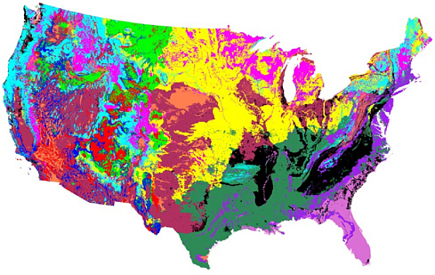
FIGURE 3-1 Human-impacted water environment classes in the continental United States, based on land slope, bedrock permeability, soil permeability, air temperature, precipitation, land cover, population density, and water use.
SOURCE: Dozier et al. (2009).
As noted in Chapter 2, the Science Plan does not clearly articulate compelling questions or hypotheses that require integration across individual observatories at the same time (i.e., that satisfy the strict requirement for a science network). Rather, the proposed network of observatories appears to be a collection of many strong pieces. The science questions posed are excellent at the vision level, and the committee believes that the case for requiring a science-based network to address the questions can indeed be made. It will be essential for the WATERS planning team to build the case for a network and develop the rationale for an integrated spatial and temporal intersite comparison as part of the next conceptual design planning stage. This issue is described in more detail in Chapter 4.
CONCLUSIONS AND RECOMMENDATIONS
Networks are needed to collect uniform information and test hypotheses across temporal and spatial scales. The WATERS Science Plan recognizes the strengths and usefulness of a network of observatories for addressing water issues that relate to the nation as a whole. However, the Science Plan does not clearly articulate specific questions that require a national network. Entering the conceptual design stage, MREFC projects need to articulate plans for a “site-independent description of the research infrastructure and technical requirements needed to meet the science” (NSF, 2007). To meet this requirement, the WATERS team would need to consider the criteria for networked sites and clarify what commonalities link the sites to form a network.
As the WATERS team goes forward, the WATERS team should bolster its case that a national network of observatories is required to address the science questions that are posed. Are there national-scale testable hypotheses that only a network of observatories such as the one envisioned by WATERS could address? These testable hypotheses would be intermediate between the three high-level science questions and the specific science cases (exemplified by snow hydrology, eutrophication, and the urban engineered system in the Science Plan; see Chapter 2). Because one of the clear strengths of the WATERS Network is the integration of hydrology, engineering, and aspects of the social sciences, the national-scale testable hypotheses should integrate across these disciplines.
The WATERS Network faces at least three major challenges in future planning to achieve their full advantages over a less integrated set of
observatories: (1) identifying the common bases that facilitate intersite comparisons; (2) matching methodologies with the science questions and developing common protocols; and (3) maintenance, management, and long-term operation. With respect to common bases, the Science Plan recognizes that the WATERS observatories need to be selected on the basis of a map uniquely designed for the WATERS program. The factors used to construct the present HIWEC map in the Science Plan may not be the most appropriate. Therefore, the committee recommends that the factors (data layers) that are used to generate the HIWEC map be thoroughly evaluated and debated to ensure that the most appropriate data are used to address the WATERS Network science questions. Developing appropriate methodologies and plans for network operations and maintenance will be critical issues to consider in the conceptual design stage ahead.


