
3
Infrastructure Issues
NAVAL INFRASTRUCTURE AND GLOBAL AND LOCAL SEA-LEVEL RISE—BACKGROUND
Among the many manifestations of climate change projected for the next several decades, sea-level rise is both highly certain to occur and highly certain to come with economic costs. This chapter begins with a review of historic sea-level change and the lack of precision in future sea-level prediction for future naval planning. The chapter then discusses the regional aspects of sea-level rise and the need for individual naval base assessments—to include the role of storm surge. The chapter concludes by reviewing recent preliminary naval coastal installation vulnerability assessments and makes suggestions for improving these assessments going forward.
The rate of sea-level rise has apparently accelerated in recent decades, although in the projections of further rise during the current century, an additional large uncertainty is how global change will be manifested locally. Local impact will in large part depend on changes in ocean circulation. An additional exacerbating condition relates to storm surge and the likelihood that some storms will intensify with further warming of the atmosphere and ocean.1 Sea-level rise is not uniform around the globe, and the potential coastal impact of regional sea-level rise is not linear with elevation. Sea-level rise even in the lower range of projections will challenge the utility and perhaps even viability of some shore-based
facilities. (Figure 3.1 and Box 3.1 provide illustrations of potential sea-level rise impact and the compounding impact of sea-level rise and storm surge.)
Precision in the measurement of changes in globally averaged sea level was improved substantially in the early 1990s with the deployment of the TOPEX/
![FIGURE 3.1 Potential regional impact of future sea-level rise. Several static and dynamic models are being developed for projecting the regional impact of sea-level rise. This figure shows potential impact to wetlands in the U.S. mid-Atlantic region under various sea-level rise scenarios (areas where wetlands would be marginal or lost [i.e., converted to open water] under three sea-level rise scenarios, in millimeters [mm] per year [yr]). Such scenarios may be applicable on a gross scale for judging first-order impact on naval installations. SOURCE: Reprinted from Figure ES.2, Coastal Sensitivity to Sea-Level Rise: A Focus on the Mid-Atlantic Region. A report by the U.S. Climate Change Science Program and the Subcommittee on Global Change Research, 2009, U.S. Environmental Protection Agency, Washington, D.C.](/openbook/12914/xhtml/images/p2001dcd5g64001.jpg)
FIGURE 3.1 Potential regional impact of future sea-level rise. Several static and dynamic models are being developed for projecting the regional impact of sea-level rise. This figure shows potential impact to wetlands in the U.S. mid-Atlantic region under various sea-level rise scenarios (areas where wetlands would be marginal or lost [i.e., converted to open water] under three sea-level rise scenarios, in millimeters [mm] per year [yr]). Such scenarios may be applicable on a gross scale for judging first-order impact on naval installations. SOURCE: Reprinted from Figure ES.2, Coastal Sensitivity to Sea-Level Rise: A Focus on the Mid-Atlantic Region. A report by the U.S. Climate Change Science Program and the Subcommittee on Global Change Research, 2009, U.S. Environmental Protection Agency, Washington, D.C.
Poseidon satellite altimeter, followed by later high-precision satellite altimeter missions. As a result, it is now possible to detect acceleration in sea-level rise over the past few decades.2 The current estimated rate (3 mm/year) is already at the upper limit of the range of global sea-level rise projections that were presented 20 years ago in the first Intergovernmental Panel on Climate Change (IPCC) assessment. Although this rate is small relative to the magnitude of tidal excursions at most localities, the probability of sea level rising at this rate or faster (while adding to tidal excursions and storm surges) over the next century requires serious assessment of the implications for coastal facilities.
Sea level has changed in the past with major climate cycles, dramatically so, relative to projections for future decades. During the last glacial maximum about 18,000 years ago, the accumulation of ice on land resulted in the surface ocean being approximately 120 meters below current levels.3 With the melting of most of this ice over a few thousand years, sea level rose to near its current level. As the human population grew over the past few centuries, a relatively stable sea level led to the extensive development of coastal margins for habitation and economic enterprise. This legacy of successful coastal development reflects the history of sea level within tidal variation and the degree to which related vulnerability issues are occasionally amplified by coastal storms. A 1900 hurricane in Galveston, Texas, with 8,000 fatalities, is a case in point. A rise of 0.5 meter over several decades will be of enormous consequence for coastal cities and naval installations that experience only small natural tidal variation. For example, such an increase in sea level will have significant consequences for St. Petersburg, Florida (typical tidal excursion up to 0.7 meter), but virtually none for Anchorage, Alaska (typical tidal excursion 10 meters).
The 2007 IPCC Fourth Assessment Report (AR4) projected changes in global average sea level under various scenarios considering glacier and ice sheet mass loss, but recognized that there was much uncertainty in the results. This lack of precision is because observational records of sea-level rise are short and therefore subject to uncertainty; in addition, the understanding of how glaciers and ice sheets will respond to increased temperature changes is very poor.4
Work published since the 2007 IPCC report suggests that loss of ice from small ice bodies (e.g., mountain glaciers and small ice caps) may have been
|
BOX 3.1 Sea-Level Rise and Storm Surge The effect of rising mean sea levels at naval coastal installations will be felt most profoundly during extreme storm conditions when strong winds and low atmospheric pressure bring about a temporary and localized increase in sea level known as a storm surge. Storm surge is simply water that is pushed toward the shore by the force of the winds swirling around the storm. This advancing surge combines with the normal tides to create the storm tide, which can increase the mean water level 15 feet or more. In addition, wind-driven waves are superimposed on the storm tide (see Figure 3.1.1). 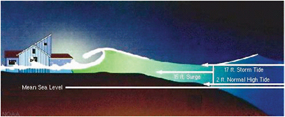 FIGURE 3.1.1 Sea-level rise and storm surge. SOURCE: Courtesy of NOAA. This rise in water level can cause severe flooding in coastal areas, particularly when the storm surge coincides with the normal high tides. Storm surges occurring on higher mean sea levels will enable inundation and damaging waves to penetrate further inland, increasing flooding, erosion, and the subsequent detrimental impacts on built infrastructure and natural ecosystems. At coastal naval instal |
underestimated5,6 and that major changes in Greenland and Antarctic ice sheet dynamics can take place over relatively short timescales. These changes should
|
lations where coastlines lie less than 10 feet above mean sea level, the impact from intense storm tides can be especially severe. For example, the August 2005 Hurricane Katrina—a Category 3 hurricane at landfall with 120 mph (195 km/h) sustained winds—produced a U.S. record storm surge, with peak surges estimated at 30 to 35 feet high (9 to 10 meters) and inland water reaching 6 to 12 miles (10 to 19 km) from the beach. The impact of sea-level rise and the inundation caused by storm surge on naval facilities in a particular area is determined in part by the slope of the continental shelf and shoreline elevation. A shallow or gentle slope off the coast (right side of Figure 3.1.2) will allow a greater surge to inundate coastal communities. Communities with a steeper continental shelf (left side of Figure 3.1.2) will not see as much surge inundation, although large breaking waves can still present major problems. 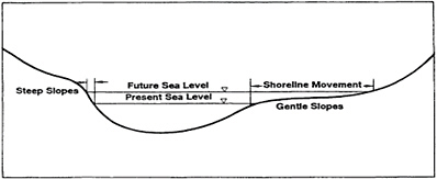 FIGURE 3.1.2 Continental shelf and shoreline elevation representation. SOURCE: Adapted from data provided by NOAA. |
be considered when planning for future sea-level increases and for naval scenarios in response. The mechanisms that could potentially drive rapid ice sheet change include meltwater drainage with an increase in basal lubrication, glacier surging due to basal hydrology changes, ice sheet/ocean interactions enhancing glacier melt by contact with warming seawater, and ice sheet thinning due to the loss of
ice shelf buttressing.7 It has also been recognized that discharge rather than surface mass loss alone can dominate ice sheet mass balance in Greenland; this implies the importance of ice dynamics in future sea-level projections.8 Although ongoing studies are attempting to incorporate these and other processes into future ice sheet dynamic models, and hence sea-level rise projections, the state of knowledge to accomplish this is at present lacking.
Several studies since the last IPCC report have approached the prediction of future sea level by refining previous ice loss estimates using different approaches. By considering observational data from the accelerated loss of ice from small glaciers and the dynamics of small marine terminating glaciers, several researchers have suggested an additional 0.1 to 0.25 meter to the global sea-level estimates reported in the IPCC’s Fourth Assessment.9 The most recent work on this topic proposes that a lower bound for the global contribution of melt from small glaciers and ice caps could be as much as 0.37 meter over the next 100 years.10 In 2007, the IPCC projections of the contribution from small glacier and ice cap melt to the sea level were between only 0.10 and 0.12 meter. In regard to the larger ice masses, recent work using a kinematic approach to determine plausible velocities of outlet glaciers in both Greenland and Antarctic has led to an indication of global average sea-level rise ranging from 0.4 meter to 2 meters by 2100.11 An examination of the various estimates leads the committee to regard a 0.8 meter global average sea-level rise by 2100 as a reasonable planning target for naval leaders. These estimates are subject to change and should be reviewed routinely.
In 2008, the National Intelligence Council judged that more than 30 U.S. military installations were already facing elevated levels of risk from rising sea levels. Research is ongoing in this important area, but more is needed in order first to better quantify glacier dynamics in a warming world and then to assess the impact of these dynamics on glacier ice loss and future sea-level rise.
Regional Aspects of Sea-Level Rise
Although a great deal of attention has focused on the question of mean sea-level rise, it is the regional variations that are of most serious concern to naval
forces and their installations. Worst-case regional changes are more than an order of magnitude greater than the global mean (see Figures 3.1 and 3.2). Global mean sea-level rise is primarily of concern to scientists attempting to balance global heat and water budgets. It is notable that in some regions of the world local sea level has been falling for more than a decade, albeit most places are experiencing apparent rises.
The large inferred relative regional changes in sea level arise from the combined effects of local changes in the freshwater balance (evaporation, precipitation, runoff, groundwater drawdown, and subsurface percolation); changes in the heat exchange with the atmosphere; and—probably the dominant effect—shifts in the wind patterns (both locally and globally) and isostatic rebound. Understanding the trends in regional sea level requires an understanding of oceanic general circulation, based on in situ and remote sensed data, regional and global circulation models, and shifts in land-ice volume.
Recently, a number of groups12,13 have begun making claims of skill in decadal forecasting of regional sea-level change. These, in turn, are forecasts of the ocean circulation that directly involve decadal forecast ability not just of the ocean but also of the overlying atmosphere and cryospheric components. The evaluation of such efforts, a determination of their probability of success, and the design of sensible naval responses to protect coastal assets present a major scientific problem for which the Navy requires its own expertise.
In many situations, neither the regional nor the global sea level is directly of primary interest. Rather it is the increased vulnerability of coastal areas to extreme events (storm surges) and the dependence of such events upon changes in regional relative sea level, tidal amplitudes, and the nature of extreme meteorological forces that are of greatest importance.14,15 Therefore, evaluating future risks for naval installations involves an understanding of changes in storm frequency as well as local sea-level rise. Each and every naval facility has a unique configuration and requires ongoing evaluation of changing risks as the climate changes.
Figure 3.2 shows the estimated trend in sea level from use of altimetric data alone.16 Figure 3.3 displays the anomaly (the global mean having been subtracted) from the combination of altimetry with temperature, salinity, and transport esti-
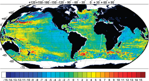
FIGURE 3.2 Observations from the TOPEX-Poseidon altimeter satellite of the global rise in sea level over about 12 years (in mm/yr). SOURCE: Courtesy of NASA/JPL-Caltech. Available at http://www.jpl.nasa.gov/imagepolicy/.
![FIGURE 3.3 Estimated sea-level change over 12 years (in m/yr) from a combination of altimetric, in situ observations and a general circulation model (updated from C. Wunsch, R. Ponte, and P. Heimbach, 2007, “Decadal Trends in Sea-Level Patterns: 1993-2004,” Journal of Climate [pdf]). SOURCE: Courtesy of NASA/JPL-Caltech. Available at http://www.jpl.nasa.gov/imagepolicy/.](/openbook/12914/xhtml/images/p2001dcd5g71001.jpg)
FIGURE 3.3 Estimated sea-level change over 12 years (in m/yr) from a combination of altimetric, in situ observations and a general circulation model (updated from C. Wunsch, R. Ponte, and P. Heimbach, 2007, “Decadal Trends in Sea-Level Patterns: 1993-2004,” Journal of Climate [pdf]). SOURCE: Courtesy of NASA/JPL-Caltech. Available at http://www.jpl.nasa.gov/imagepolicy/.
mates of a great variety of types. That the two pictures differ in some significant aspects is a reflection of the oceanographic complexity of the problem. The large magnitudes of the regional shifts, much larger than the global mean, lead to the inference that shifts in the wind fields driving the ocean circulation are a major element and would have to be part of any predictive system.
FINDING 3.1: Peer-reviewed literature since the 2007 Intergovernmental Panel on Climate Change Fourth Assessment Report (AR4) suggests that loss of ice from small ice bodies (e.g., mountain glaciers and small ice caps) may have been underestimated in the last IPCC report and that major changes in Greenland and Antarctic ice sheet dynamics can take place over relatively short timescales. Sea-level variations caused by shifts in wind, rain, evaporation, and land-ice volume can cause far greater local changes in sea-level variations than the global mean rise that is projected from thermal expansion of the ocean and land-surface meltwater runoff.
RECOMMENDATION 3.1: Based on recent peer-reviewed scientific literature, the Department of the Navy should expect roughly 0.4 to 2 meters global average sea-level rise by 2100, with a most likely value of about 0.8 meter. Projections of local sea-level rise could be much larger and should be taken into account for naval planning purposes. However, U.S. naval leadership (e.g., the Oceanographer of the Navy) should be aware that this estimate is subject to change, and it should be reviewed routinely for any significant change.
Assessing Exposure to Sea-Level Rise
Exposure to damage from future sea-level rise for naval installations will vary from locality to locality. No nation with coastal exposure will be spared the impacts of future sea-level rise; indeed, the viability of some island nations will be at risk if upper ranges of projected sea level materialize over the next few decades. In the aggregate, the effects of sea-level rise and more intense storms on infrastructure and facilities that constitute our built environment will be among the most unequivocal impacts of global climate change.
Each coastal naval installation needs to be examined individually. Thus predictions of greater-than-average sea-level rise along the coast of the Carolinas, coupled with potentially strengthened tropical and subtropical disturbances, would render bases there much more vulnerable than in areas where mean sea level has been falling, such as Diego Garcia. But even the latter would be subject to shifts in tropical cyclone intensity and fluctuations. Generalizations are difficult to make beyond the need to regard each facility as requiring specific scrutiny and assessment of risk.
Increased exposure for coastal regions due to both sea-level rise and inten-
sified coastal storms provides a good example of the value of a well-developed vulnerability analysis and decision making based on risk management principles.
FINDING 3.2: Neither regional nor global sea level is of primary interest in determining naval coastal installation vulnerability. Rather, it is the increased vulnerability associated with extreme events (storm surges) and their dependence on changes in regional sea level, tidal amplitudes, and the nature of extraordinary meteorological forces that are of greatest importance.
RECOMMENDATION 3.2: In performing vulnerability analysis, naval facility managers should recognize that each and every naval facility has a unique configuration and requires ongoing oversight of the changing risks as the climate system shifts. For example, local storm surge impact in climate-induced extreme storm events is likely to represent a bigger vulnerability risk than will sea-level rise alone.
NAVAL COASTAL INFRASTRUCTURE ISSUES
As stated above, global sea-level rise has significant potential to affect many naval coastal installations.17 These installations are enduring facilities, predominately in the coastal zone, that have been built to last for decades. All were constructed before climate change was recognized as a factor in their design and construction.18
The committee reviewed two preliminary assessments of U.S. military coastal installations at risk from coastal inundations caused by sea-level rise.19
Many of the U.S. military installations identified at “very high risk” or at “high risk” are naval installations.20 These assessments provide a starting point for more in-depth evaluations. As directed by requirements for the Department of Defense’s (DOD’s) Quadrennial Defense Review (QDR), a broader and more detailed assessment will provide a foundation, but there is a clear need for a more detailed global analysis and an action plan to address the vulnerabilities of those coastal installations identified as being at “very high risk” and at “high risk.”21 The assumptions, decisions, and time lines for addressing these risks should be determined on a consistent basis across the DOD and all naval services. The committee suggests that additional risk factors beyond current indicators of sea-level rise, tidal range, and coastal geomorphology be included in future analyses, including factors such as regional extreme weather history and potential impacts on critical infrastructure—such as communications, transportation, and utilities. In addition, groundwater drawdown and replenishment, saltwater intrusion, and recharge of the aquifer to prevent subsidence are critical factors to take into account in coastal vulnerability analyses. The committee believes that these analyses must explicitly address the potential impact that the combined issues of sea-level rise and more intense storm surges could have on critical military missions.
Some specific impacts that can be anticipated include effects on piers, utilities, and freshwater. Piers will be affected by the sea level relative to the height of the pier as the force exerted by the ship and waves on the pier may grow to be outside the original structural design criteria.22 This may require significant modifications of piers and waterfront structures at naval shore stations. Utilities such as electrical substations, sewage treatment facilities, and communications nodes, as well as other important and critical infrastructures on the base, may be destroyed or seriously degraded by flooding caused by sea-level rise. Adverse weather can have a deleterious effect on the aboveground utilities system due to high winds,
|
Maj Gen Richard Engel, USAF (Ret.), Director, Climate Change and State Stability Program, National Intelligence Council, “National Intelligence Assessment on the National Security Implications of Global Climate Change to 2030,” presentation to the committee, October 19, 2009, Washington, D.C. For additional information on the CVI, the reader is referred to the USGS’s National Assessment of Coastal Vulnerability website; available at http://woodshole.er.usgs.gov/project-pages/cvi/. |
lightning, and so on. Utilities can be hardened against this type of condition, but at a cost. Saltwater intrusion into aquifers caused by rising sea level where bases draw their freshwater will impact the availability and cost of freshwater.
In addition to facilities management challenges, there are other considerations related to climate change impacts on Navy and Marine Corps installations. Missions of various naval installations may be affected by the increased requirement to support contingency operations in the humanitarian assistance/disaster relief (HA/DR) area. The impact will be felt mostly in the area of logistics. Although bases have contingency plans for many kinds of events, the plan for evacuation due to flooding may require revision as well as more frequent assessment than is required now. Communities surrounding naval installations may also be stressed and require contingency plans, including the need to address potential impacts to coastal wetlands and ecosystems and on local public health.23,24
CURRENT NAVAL COASTAL VULNERABILITY STUDIES
There are currently at least three separate Navy groups involved in the analysis of coastal installation vulnerability issues for the Navy: the Naval Space Warfare Systems Command (SPAWAR), the Naval Facilities Engineering Service Center (NAVFESC),25 and the Naval Installations Command.26 Additionally, prior to the 2010 QDR the U.S. Marine Corps began conducting an analysis of
its coastal vulnerabilities.27 Also, the DOD’s Strategic Environmental Research and Development Program (SERDP) has initiated climate change military infrastructure studies.28 This committee believes that to avoid duplication of effort and to ensure a more comprehensive and consistent assessment, a more coordinated vulnerability analysis is needed across the naval installations nationally and internationally. This effort should also be coordinated with vulnerability assessments for other military installation across the DOD.
The Office of the Chief of Naval Operations, N46 (Shore Readiness), informed the committee that the Navy is reviewing the Military Construction Program to evaluate the impact of climate change on the facilities in the program. Life-cycle costing and impacts of climate change, energy reduction, and reduction of greenhouse gases can all be considered in investment decisions by the services. This approach is also recommended for non-DOD naval forces in their capital investment decisions.
Considering the current measurements for sea-level rise, it is not anticipated that the Navy will need to make a major resource investment in the near term, with the exception of those naval installations currently identified as being at very high risk. However, on the longer time horizon (the next 10 to 20 years), investments will have to be made for adaptation and mitigation of climate impacts at many naval coastal installations, and those investments may have implications for decisions being made today.29
As the mission of naval forces changes to meet the demands of climate change, it is also suggested that the Navy team review the potential requirement for new bases. This would include new enduring bases in places like the Arctic, the increased ability to logistically support sea basing of efforts much like the recent efforts in Haiti during earthquake recovery, and, finally, new requirements for contingency bases in response to world situations that may take the Navy to new places like Iraq and Afghanistan. Even though all these types of basing are within the current capability of the U.S. Navy, the impact of climate change should be routinely evaluated for all future naval base decisions.
A 1987 National Research Council report explores engineering considerations for dealing with sea-level rise and recommends a multiple-scenario
|
27 |
Elmer W. Ransom, Environmental Management Section, Headquarters, U.S. Marine Corps, and Capt Anthony V. Ermovic, USMC Facilities Branch Head, Headquarters, U.S. Marine Corps, “Marine Corps Perspectives and Climate Change Initiatives,” presentation to the committee, September 18, 2009, Washington, D.C. |
|
28 |
The Office of the Secretary of Defense’s Strategic Environmental Research and Development Program currently sponsors several projects related to the assessment of the impact of global sea-level rise on military infrastructure. These projects are managed under SERDP’s Sustainable Infrastructure Projects Program. Descriptive information on these projects (SI-1700, -1701, -1702, and -1703) is available at http://www.serdp.org/Research/SI-Facilities-Management.cfm. Accessed April 17, 2010. |
|
29 |
The Navy’s investment needs, if any, would be reflected in Program Objective Memorandum (POM) submissions. The POM submission is a 5-year outlook on budget requirements. It starts with the year following the President’s Budget, which is always 1 year ahead of the current year. |
approach to deal with uncertainties for which no reliable or credible probabilities can be obtained. While this 1987 report is dated from the observed sea-level rise data that it presents, its recommended approaches to deal with sea-level changes remain valid and should be considered by naval facilities management.30
FINDING 3.3: U.S. Navy, Coast Guard, and Marine Corps coastal installations around the globe will become increasingly susceptible to projected climate change. Several assessments now under way on naval installation vulnerabilities appear to be focused primarily on static sea-level rise and coastal inundation only. According to these current assessments, some adaptive actions are indicated owing to already identified vulnerabilities at specific naval installations. The preliminary review of climate-change-related base vulnerabilities across the DOD—currently under way as directed by the 2010 Quadrennial Defense Review31—does not include some important factors that affect coastal installation vulnerabilities, although it provides a baseline assessment across all branches of the armed services and serves as a starting point for more in-depth analysis and action.
RECOMMENDATION 3.3a: The Commander, Naval Installations Command, and the Navy Director for Fleet Readiness and Logistics should work with their U.S. Coast Guard and Marine Corps counterparts—and in conjunction with the other armed services and the Office of the Secretary of Defense—to ensure that a coordinated analysis is undertaken to address naval-installation vulnerability to rising sea levels, higher storm surges, and other consequences of climate change. In performing this vulnerability analysis, naval facility managers should recognize that each and every naval facility has a unique configuration and requires ongoing oversight of the changing risks as the climate system shifts. For example, local storm surge impact in climate-induced extreme storm events is likely to represent a bigger vulnerability than sea-level rise alone.
RECOMMENDATION 3.3b: For Program Objective Memorandum (POM)-14 planning purposes, the Chief of Naval Operations should prepare to invest in early-stage adaptation for targeted low-elevation naval installations identified in current vulnerability assessments as being at “very high risk” from more intense storm surges, sea-level rise, and other climate change impacts. Other risks for naval installations as a result of projected climate change require further analysis and planning at this time, but no immediate direct additional substantial investment beyond current budget plans.
FINDING 3.4: The U.S. military is well aware of the risks to its coastal facilities and infrastructure from sea-level rise. Recent observations of sea-level rise have exceeded projections made only a decade earlier, and the increasing realization of the potential of changes in ice dynamics leads to the further realization that there perhaps continues to be underestimation of the sea-level rise that would be associated with likely future climate change. The risk of harm to military and civilian coastal facilities from sea-level rise is not linear with the rate of rise. There will be thresholds at which existing natural and built coastal barriers are exceeded. An important dimension of this risk is that of storm surge, especially if warmer future conditions give rise to an increased intensity of storms.
RECOMMENDATION 3.4: For risk management purposes, U.S. naval leaders would be prudent to err on the side of overestimation of future sea-level rise when renovating existing or planning new coastal facilities. The Navy and other branches of U.S. services that have historic commitments to HA/DR efforts for the United States and beyond need to consider as highly probable the need to enhance these capabilities to be prepared for increased damage from coastal storms.


