
4
The Geodetic Infrastructure: Current Status and Future Requirements
The geodetic infrastructure consists of two principal components: (1) the network of observation instruments for each geodetic observation technique; and (2) associated international services composed of the various scientists, technicians, and administrators that support each technique. This chapter describes the current status of the main geodetic networks, the Earth observation satellites that underpin those networks, and the international services that support them as well as future technological and organizational needs in each of these areas.
GEODETIC NETWORKS
Very Long Baseline Interferometry (VLBI)
VLBI is a geometric technique that employs radio telescopes located thousands of kilometers apart to observe natural radio sources that are located billions of light-years from the Earth, such as quasars (see Figure 4.1). Although the observations from these telescopes are useful for radio astronomy, they also have important applications for geodesy. Because the radio sources are at such extreme distances they appear fixed in space and provide the most stable celestial reference frame (the reference frame that does not rotate relative to distant stars and is centered at the Solar system’s center of mass) that currently can be defined. As a result, VLBI is the definitive technique for tracking changes in the orientation of Earth in space, including precession, nutation, Earth rotation and, when VLBI is combined with Global Navigation Satellite Systems/Global Positioning System (GNSS/GPS) measurements, polar motion. The VLBI infrastructure includes the radio telescopes (“VLBI observatories”) and central data processing facilities called correlator centers. Each technique also has an associated international service that is a critical component of the infrastructure; these services are discussed later.
The International VLBI Service is an international collaboration of organizations that operate or support VLBI infrastructure (Schlüter and Behrend, 2007). Figure 5.1 illustrates the geographical distribution of the VLBI observatories that contributed geodetic data during 2008. The antennas in Fortaleza, Brazil and Hartebeesthoek, South Africa are currently inoperative but repair plans are
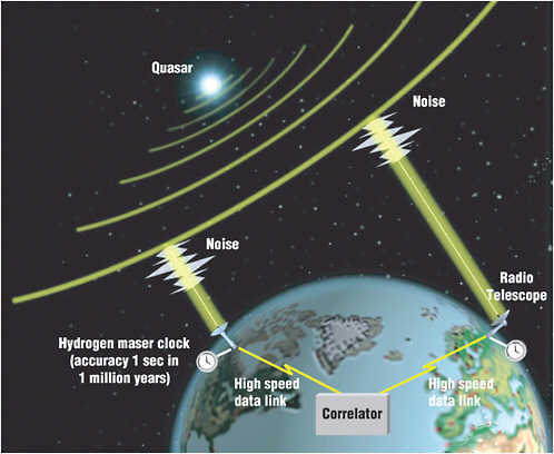
FIGURE 4.1 The VLBI technique uses multiple radio telescopes to measure natural radiometric noise from distant radio sources, such as quasars. The differences in the arrival time for the same radio noise at separate antennas are later correlated to determine the time delay between the two antennas to millimeter precision. By observing radio sources in multiple directions, the VLBI network can be used to determine Earth’s geometric shape and orientation in space. SOURCE: NASA, Goddard Space Flight Center.
in place. The two Canadian VLBI stations at Yellowknife and Algonquin have been shut down. The U.S. VLBI site in Gilmore Creek, Alaska was closed by NASA, and the geodetic VLBI site at Green Bank, West Virginia (originally part of the U.S. Naval Observatory program for Earth orientation) closed in 2001. There are currently no prospects for restoring either of the closed U.S. sites. Furthermore, those U.S. sites that are operational are not all operating routinely. Except for the sites at Kokee Park, Hawaii and Westford, Massachusetts, most U.S. VLBI sites collected less than ten days of data during 2009. If four non-colinear U.S. sites were routinely operational for geodetic observations, this would be sufficient for USNO to determine Earth’s orientation using U.S. resources only. Currently, USNO has to rely on international partners for its Earth orientation determination.
Several factors make the VLBI technique challenging and costly. First, the requirement that data from VLBI observatories must be physically shipped to a special correlator center for processing can introduce delays in determining Earth-orientation parameters. The signals from quasars far from Earth are weak and it is necessary to process the data from VLBI observatories centrally in order to separate the signals from background noise. In addition, obtaining usable signal-to-noise levels using
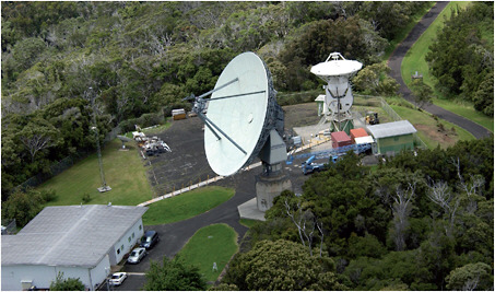
FIGURE 4.2 The 20-meter antenna at the Kokee Park Geophysical Observatory, NASA’s VLBI station in Hawaii, is one of the most active sites in the global VLBI network. SOURCE: U.S. Navy Pacific Missile Range Facility.
VLBI requires large directional antennas (see Figure 4.2) that are able to move rapidly to obtain the required geometrical distribution of observations. This requirement makes VLBI instruments technologically complex and costly, and it is difficult to determine the location of the antenna’s reference point at the desired one-millimeter-level for such large antennas (see Chapter 5).
The requirements outlined in the Global Geodetic Observing System project of the International Association of Geodesy, combined with the science goals specified in the NASA Solid Earth Science Working Group Report, establish three main criteria for the next generation of geodetic VLBI systems (VLBI2010) (Niell et al., 2006). These include one millimeter measurement accuracy, continuous measurements for station positions and Earth orientation, and a turnaround time of less than 24 hours.
Recommendation: To pursue these system enhancements, the United States should invest in the following future developments to make VLBI more effective and less expensive:
-
Radio telescope apertures should be reduced (to 10-12 meters) by increasing the recorded signal bandwidth. The benefits of smaller telescope apertures include: lower manufacturing and maintenance cost; higher attainable slew rates; lower instrument distortions associated with temperature changes and gravitational and wind loading; increased ease of locating the effective reference point; and reduced cost of piers and domes at observing stations. The optimal radio telescope parameters for geodetic applications are different than those for astronomical applications. The geodetic infrastructure must, therefore, include a dedicated network of geodetic VLBI observatories to obtain continuous measurements. In addition, using multiple VLBI antennas at some locations may yield improvements in accuracy and lead to better separation of atmospheric delay and clock parameter estimates. Although there is a need for a VLBI network dedicated to geodetic applications, correlator centers can efficiently process both geodetic and astronomic VLBI
-
observations, and it appears that both communities can and should collaborate on the development of future generations of VLBI instrumentation.
-
VLBI observations should be transferred from the observing stations to the correlator center(s) using high-speed communication systems. A small, but growing, number of VLBI sites are already using high-speed communication systems to transfer data. Using electronic data transfers can reduce the delays in processing “e-VLBI” observations to hours. Shorter delays would reduce the dependence on prediction models for determining the Earth’s orientation, which is particularly important for deep space tracking and military uses. New correlator designs, possibly including widely-distributed correlators rather than a single, central location, as well as more automated data processing may be required to handle the anticipated higher data rates.
-
VLBI data processing and products are not well integrated into geodetic products generated by other systems, though integrated products could improve the accuracy of VLBI results. VLBI data analysis centers should consider using products from GNSS/GPS data analyses, such as polar motion and atmospheric delay estimates, in the generation of VLBI products. The combined analysis would aid in terrestrial reference frame realization using VLBI networks with a small numbers of sites. The multi-look angles available with GNSS/GPS observations also could assist in accounting for atmospheric delays in VLBI processing, and the combined analyses would aid in integrating the VLBI analysis centers into the GNSS/GPS community.
GNSS/GPS
GPS1 is now ubiquitous in civilian life, but it also provides a critical component of the geodetic infrastructure. GPS operates by broadcasting predetermined coded signals, including predicted satellite positions from multiple dedicated satellites, and then correlating those signals with internally-generated versions of the same signals inside GPS receivers on the ground (Figure 4.3) or in other platforms, such as vehicles, ships, planes, or spacecraft. This correlation is used to measure the distances between the satellites and the receivers; given prior knowledge of satellites’ positions in space, the user’s time and position are subsequently determined with respect to the terrestrial reference frame (e.g., WGS 84 or ITRF). For more precise applications, geodetic GPS receivers track the carrier signal directly in addition to the codes, enabling measurements with a precision of a few millimeters. The existing GPS infrastructure may be broken down into three basic areas: (1) military operations that maintain the system and generate broadcast satellite orbital position and timing data (i.e., ephemeris); (2) infrastructure that has been installed primarily to address scientific questions; and (3) other networks that have been installed to support civil engineering and surveying projects. The latency of data distribution from these networks varies between real-time transmissions of data to several month-long lags for scientifically important locations lacking easy communications links.
There are thousands of GPS receivers distributed around the world, and the sizes of the networks controlled by single entities vary greatly. The Operational Control Segment network used to generate the broadcast ephemeris data for civil and military navigation is probably the smallest but most secure, with just six Air Force stations and enhanced by eleven NGA stations distributed around
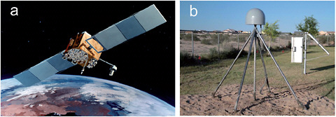
FIGURE 4.3 (a) An illustration of a Block-IIF GPS satellite and (b) a geodetic GPS receiver in San Luis, Arizona. SOURCE: Image courtesy of the United States Air Force (right) and photo courtesy of the Plate Boundary Observatory, the geodetic component of EarthScope, operated by UNAVCO and funded by the National Science Foundation (left).
the world. The network coordinated by the International GNSS Service (IGS), which provides the GPS component of the ITRF, consists of approximately 360 active stations (see Figure 5.1). The largest scientific network in the United States is the Plate Boundary Observatory (PBO) operated by UNAVCO for the National Science Foundation under its EarthScope Project. This network contains more than 1,100 high-accuracy GPS stations including 875 new stations built by the PBO and an additional 200 stations upgraded from networks that existed before the development of the PBO in 2004. Other scientific networks in the United States include the Bay Area Regional Dense array (BARD) near San Francisco Bay, the Pacific Northwest Array (PANGA), and others. These networks add approximately another 300 stations to the scientific networks. Within the United States, the largest network in support of surveying applications is the Continuously Operating Reference Station (CORS) network coordinated by the National Geodetic Survey (NGS). The stations in this network are operated by many different entities, but the distribution and archiving of data is carried out by the NGS. The NGS also sets the standards required for stations that are to be part of the CORS network. Currently, there are about 1,600 stations listed as CORS sites; many of these are also used as scientific stations.
Two major developments are occurring that will affect future applications of these GPS networks: (1) there is an increasing trend toward real-time access to high-sample rate data (one hertz and higher); and (2) new GNSS satellites are being developed that will add many more satellites and data types to the existing constellations. The transition to real-time data collection and dissemination is driven largely by the surveying community and industry, which can use real-time data to increase productivity in the field and improve vehicle tracking and navigation on local and global scales, respectively. In addition, the scientific community can use these data for developing warning systems for tsunamis and volcanic eruptions. It is expected that more GPS stations will be converted to real-time operation to support these types of activities. These new real-time applications affect the costs of network operations because they require continuously-operating data streams and the archival of high-rate data streams. On the other hand, real-time data are valuable for multiple uses, providing a broad community that can support the costs of these networks. In southern California, the maintenance of some of the real-time, high-rate stations in the Southern California Integrated GPS Network is supported by surveying groups who use the data. These maintenance efforts are coordinated through the California Spatial Reference Center.2
|
2 |
California Spatial Reference Center Website: http://csrc.ucsd.edu/ |
The other development that will affect existing GNSS/GPS networks is the transition from GPS-only receivers to combined GNSS/GPS receivers. Combined GPS-GLONASS receivers are now readily available and deployed by the IGS and for commercial applications. The current GLONASS constellation numbers 21 operational satellites with three more scheduled for launch in September 2010 to complete the nominal 24-satellite constellation. But, the largest impact may come from the European Galileo satellite system. When fully deployed, the Galileo system will be of similar size to the GPS system with 30 satellites in medium-Earth orbit. Existing GPS receivers will need to be replaced or upgraded, and antennas may need to be replaced to handle the new frequencies to be broadcast by Galileo. Even within the GPS network new antennas may be required to receive the full signal bandwidth, including additional signals that will be transmitted in the future at new frequencies. New antennas will need to be carefully calibrated to reduce systematic changes in the geodetic reference system caused during the transition.
Several system enhancements are needed to support the current and future scientific requirements and high-precision applications for GNSS/GPS. The GPS network must be upgraded to enable one millimeter post-processing positioning precision (24 hour averaging), 10 millimeter near real-time precision (few second latency), and 10 millimeter positioning precision for low-Earth orbiting satellites. The two main aspects of infrastructure development to achieve these objectives will be upgrading the GPS network equipment and distribution to meet the accuracy specifications and upgrading the GPS stations, data communications, and data processing infrastructure to enable high-precision, real-time positioning nationwide. The former requires upgrades to many stations to ensure stability (correct monumentation) and a good electrical environment (suppression of multipath). The latter could be achieved by signal processing techniques (rapid carrier phase ambiguity resolution), which would be strongly enhanced by spacing stations approximately 50 kilometers apart to cancel common errors between the user’s receiver and the nearest network receivers. In addition, almost all GPS receiver sites will need to be upgraded in order to take advantage of signals from new GNSS systems as they come on line. Although significant technological development is required to turn current prototypes into operational systems, the barriers to these developments are a lack of systematic coordination and funding rather than technological barriers.
Significant infrastructure development, inter-agency coordination, and transfer of technology will be needed to achieve these goals. On the national scale, the current GPS network to serve high-precision applications is actually a collection of networks operated by different federal agencies including NGS, NSF, USGS, and NASA. In addition, NASA contributes to the global GNSS/GPS network operated under the IGS for precision orbit determination and for reference frame realization in order to meet scientific objectives. The global network is essential to meeting precision requirements on the national scale and so must be considered an essential part of the national geodetic infrastructure.
The various GPS networks operated by agencies of the United States are heterogeneous in terms of quality of instrumentation, site stability, and multipath environment. This is partly a result of history as the network has grown over the past 20 years and partly due to differences among various agency missions and funding models for the networks. For example, NASA has long supported the global network, which means that much of the equipment is aging, and the early engineering designs were not optimal for site stability and multipath environment. As another example, the CORS network was developed largely by accepting stations that were operated by local and regional entities (such as counties) with the result that there is little control or consistent knowledge of the station configurations, leading to a broad range of data quality. The USGS is a user of the GPS infrastructure, but it also has its own regional networks for research on seismic hazards. NSF (through UNAVCO) operates one of the largest and most recently-added networks (containing approximately 1,100 stations), but NSF has funded this network for only the duration of the EarthScope program.
Recommendation: The United States should significantly strengthen the GPS network by upgrading the instrumentation, monumentation, and technology. In addition, there should be greater coordination among the various U.S. agencies to develop strategies for meeting the needs of multiple agencies, as well as for long-term site maintenance, upgrade, data flow, and response to technological innovation.
Such coordinated planning also could significantly reduce redundancies that are caused when an agency constructs networks only to meet its own needs or when agencies are not aware of the activities of other agencies.
With regard to data processing, there are currently several agencies and universities that routinely process data from the various high-precision GPS networks using custom software. Some are official analysis centers for the IGS. These include NGS, NASA’s Jet Propulsion Laboratory, the University of California at San Diego’s Scripps Institution of Oceanography, and the Massachusetts Institute of Technology. The IGS is currently conducting a “Pilot Project” for real-time, high-precision positioning.
Recommendation: Recognizing the importance of data-processing capabilities and activities to the national interest, the United States should continue to support these real-time, high-precision operations with a long-term view (not only for research and development).
The IGS model promotes continuous innovation and improvement of product quality; as such, a service oriented approach is needed to address development and operation of the GPS network and the national geodetic infrastructure in general.
Satellite and Lunar Laser Ranging (SLR and LLR)
Laser ranging is a technique used to measure the time it takes for ultra-short laser pulses to reach retroreflector arrays on satellites or the moon and reflect back to Earth. The laser pulse is focused to a narrow beam by a telescope aimed at a satellite or the moon, and the return signal (in some cases as low as a single photon) is captured by the same telescope or by a larger, more sensitive parallel telescope (see Figure 4.4). Because the laser beam is so narrow, the orbits of the satellites or the moon must be predicted accurately and the telescopes must be pointed precisely in order for the telescopes to track their targets. Unlike radiometric techniques like VLBI, laser ranging only can operate when the sky is clear or through very thin clouds. However, the optical frequencies are much less susceptible to refraction from water vapor in the atmosphere. The precision of laser ranging has improved from a few meters in 1964 to a few millimeters today with centimeter-level absolute ranging accuracy (See Box 5.1 for a discussion of precision and accuracy). Achieving ranging accuracy at the millimeter level is an important challenge as the laser ranging community strives to improve the quality of the data.
SLR stations are operated by a variety of institutions around the world that cooperate to provide a global tracking data set for approximately 30 satellites (see Figure 5.1). Laser ranging data and analysis activities are managed by the International Laser Ranging Service (Pearlman et al., 2002). Most of the collected data are available within an hour of acquisition. Laser ranging data are used to define and maintain the ITRF (Altimimi et al., 2007), to observe temporal variations of Earth’s gravity field (Cox and Chao, 2002; Cheng and Tapley, 2004), to determine Earth and lunar-orientation parameters and other fundamental physical constants for Earth, and to perform tests of general relativity (Ciufolini and Pavlis, 2004). Laser ranging also has pro-
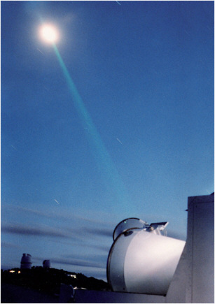
FIGURE 4.4 Lunar laser ranging by the McDonald Laser Ranging System. Lasers are aimed at retroreflectors left on the moon by the Apollo and Lunokhod missions providing range measurements accurate to a few centimeters. SOURCE: Courtesy of R. Ricklefs, McDonald Observatory.
vided a 30-year history of geodetic information (long-wavelength gravity, geocenter, and plate motion), is used to determine or verify centimeter-precision satellite orbits (Exertier et al., 2001), including ongoing altimeter (ERS-2, GFO, Jason-1, Jason-2, and ICESat) and gravity (CHAMP, GRACE) missions; and continues to provide long-wavelength gravity variations to supplement gravity missions such as GRACE.
LLR is currently performed at stations in Apache Point, New Mexico, Grasse, France, and McDonald Observatory, Texas. However, the Apache Point station, which was designed for millimeter-level accuracy is in limited operation. The Grasse site has recently restarted lunar observations after being out of operation for several years for upgrades and refurbishment. An SLR station in Matera, Italy is capable of lunar ranging but has not yet initiated a lunar observing program. In addition to performing LLR using two-way ranging to the retroreflector arrays on the moon, experiments have begun that are attempting one-way laser ranging to the Lunar Reconnaissance Orbiter.
An ongoing concern with the SLR network is the lack of uniform coverage and performance. Roughly 80 percent of the SLR tracking on the LAGEOS satellites (used for determining the ITRF) is from the northern hemisphere, and only about a third of the total tracking is from the western hemisphere. Furthermore, tracking can vary greatly from station to station depending on weather conditions and staffing resources (see Figure 4.5). Among the stations that provided more than 100 passes
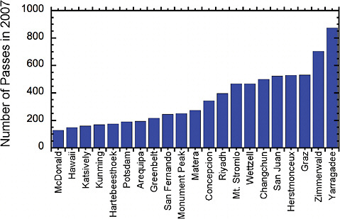
FIGURE 4.5 The number of passes obtained during 2007 from the SLR network for the altimeter satellite Jason-1 (only stations with at least 100 passes are shown), illustrating the significant range between stations in terms of data yield. SOURCE: Courtesy of John Ries.
for the Jason-1 altimeter satellite during 2007, the U.S. sites all fall in the lower half. Increasing the data yield from lower-volume sites, filling in the gaps in the SLR tracking network, and improving the overall balance in the station distribution are critical goals for the SLR system. In addition, the SLR network is threatened by reductions in operations or outright station closures due to considerable operation costs. The segment of the global SLR network that is operated by the United States is at risk of failure because the physical infrastructure is aging and many of the trained personnel in its small workforce are nearing retirement age.
Several significant enhancements are required for the next generation of SLR systems to improve data quality and reduce the cost of operation. Perhaps the most important needed improvement is to make the tracking equipment capable of fully autonomous operation yet retain the ability to acquire tracking for satellites up to GNSS/GPS altitudes. A prototype for such a system has been developed and is being tested at the Goddard Geophysical and Astronomical Observatory in Greenbelt, Maryland (a “fundamental” site where multiple geodetic techniques are co-located). In addition, multi-kilohertz firing rates, improved epoch timing, more stable ranging calibration, and operating in the single photon regime will reduce random and systematic errors for laser ranging. New applications of next-generation laser tracking stations include kilohertz-scanning of satellite surfaces (to determine the spin axis and rotation rate of spherical satellites) and atmospheric seeing measurements along the laser beam (to provide information on atmospheric turbulence). Kilohertz time transfer techniques are currently being tested on the Jason-2 mission with the Time Transfer by Laser Link (T2L2) experiment where one picosecond stability over several minutes may be achievable.
Recommendation: The United States should make a long-term commitment to deploy a new generation of SLR tracking stations capable of high-precision, high-rate, eye-safe, autonomous operation. At a minimum, these next-generation SLR tracking stations should be deployed at the four current United States tracking sites (Haleakala, Monument Peak, McDonald Observatory, and Greenbelt) to retain and extend the value of these sites for long-term terrestrial frame determination. International cooperation to improve the geographic coverage of the global SLR network and maximize the value of the U.S.-operated sites is also recommended.
To enable lunar and interplanetary applications there is also a need to upgrade more laser ranging stations to lunar ranging capability, and progress should continue in the area of laser transponders to the moon and other planets.
Doppler Orbit Determination and Radiopositioning Integrated by Satellite (DORIS)
The DORIS system is a French civil precise orbit determination and positioning system. As illustrated in Figure 4.6, DORIS consists of a network of terrestrial beacons that transmit signals to instruments onboard a satellite including an antenna, radio receiver, and an ultra-stable oscillator that provides the reference frequency standard. The onboard receiver compares the signal emitted by
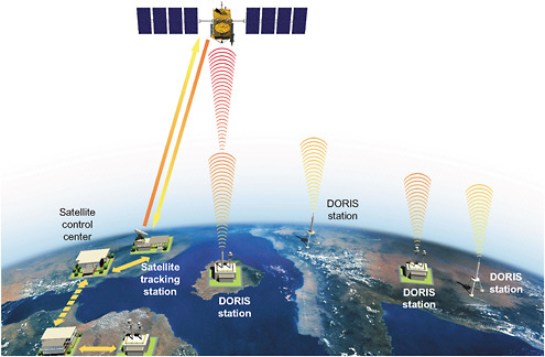
FIGURE 4.6 Schematic of the DORIS system. Ground beacons broadcast omni directionally and require only steady power. Some, called “master” beacons, are connected to high-precision time standards and can upload commands to a DORIS receiver onboard a satellite. The tracking data collected onboard is transmitted to the ground to be processed and distributed by SSALTO (Segment Sol Multimission Altimetry and Orbitography) operated by CNES. SOURCE: © CNES/ill. David Ducros.
the ground beacon against the onboard frequency standard. Because of the satellite’s velocity, the incoming signal will appear to be shifted in frequency causing a “beat” with respect to the satellite’s internal clock. Measurements of the number of beat cycles can be used to determine the velocity of the satellite, which is then incorporated with satellite orbit dynamics to determine the distance between the satellite and the ground beacon. DORIS is optimized for precise orbit determination with global coverage and all-weather measurements. The system was designed and developed by the Centre National d’Etudes Spatiales (CNES, the French Space Agency) in partnership with the Groupe de Recherche de Géodésie Spatiale (the French space geodesy research group) and the Institut Géographique National (the French national mapping agency). It was developed primarily for precise orbit determination of altimeter missions and, consequently, also for geodetic ground station positioning. The DORIS products and activities are managed by the International DORIS Service (IDS) (Tavernier et al., 2006).
The DORIS ground segment currently consists of 57 beacons with a remarkably uniform coverage around Earth (see Figure 5.1). This even coverage was established in part, because in the early development of the system, interference would occur within the receiver if the transmitters were close to each other. The new receivers, however, no longer have this limitation and can track several beacons at the same time. Nevertheless, CNES has strived to distribute the beacons evenly for the best possible performance for satellite orbit determination. One of the advantages of DORIS is that all observations are collected centrally onboard the satellites and no ground links are necessary making it possible to deploy beacons in remote and inhospitable areas (for example, islands in the southern hemisphere and Antarctica). As the ITRF attempts to achieve a no net rotation system (see Chapter 5), sites distributed over many locations on different plates is important. The scientific contributions of DORIS also increase as the time span increases providing a useful “lever arm” for station velocity determination. Some DORIS sites have been occupied since the early 1990s. The DORIS network is constantly being maintained with renovations at many of the sites to upgrade the transmitters or improve the stability of the antennas.
The DORIS network is well distributed, and the commitment of CNES to the maintenance of the system appears to be strong. Currently, there are six satellites carrying DORIS receivers, and it has been demonstrated that the DORIS positioning performance improves significantly when using four or more satellites (Altamimi and Collilieux, 2010). Consequently, installing the DORIS system on more satellites will significantly improve the DORIS contribution to positioning and geodesy applications.
Recommendation: The United States should deploy, where possible, DORIS receivers on U.S. low-Earth orbiting missions to enhance the DORIS positioning performance and the contribution of DORIS to the ITRF.
Future altimetry missions could benefit from carrying not only a DORIS receiver but also SLR reflectors and GNSS/GPS receivers to improve the inter-calibration between the three systems and for orbit precision verification.
Terrestrial (Ground and Airborne) Gravity
Differences in the height of land above the geoid—orthometric heights—determine the direction of water flow. Thus knowledge of orthometric heights is critical for applications such as estimating floodplain extent, evaluating storm surge hazards, and designing aqueducts. At present, orthometric heights in the United States are determined by tying local surveys into a network of 600,000 leveling monuments, which were established over the past century by the NGS. This
network was built up over decades using a variety of instruments and procedures with varying data quality and biases. That network has been steadily degrading as monuments are damaged or destroyed or experience unmonitored vertical motion. Today, leveling is a time-consuming, labor-intensive, and expensive surveying technique, and it is impractical to continue to maintain the existing monument network. Instead, the NGS has proposed that the United States switch to a method in which orthometric heights are determined using GNSS/GPS to measure geometric heights and then subtracting modeled geoid heights. This method is faster, less expensive, and more accurate than leveling. However, it requires an accurate, high-resolution geoid model.
The geoid is the level surface (a surface of constant gravitational potential) that, over the open ocean, approximates mean sea level. Extending the geoid to land was typically accomplished with ground-based leveling techniques, but is now augmented with global gravity field models from space techniques. Figure 4.7 illustrates the geoid over the continental U.S. based on the recent NGS geoid model GEOID09 (Roman et al. 2009) where the range in geoid height varies by approximately 50 meters. Geoid models created from satellite observations alone have spatial resolutions no better than 100-200 kilometers (see Box 4.1). In order to develop a geoid model that is accurate to the centimeter level and with a spatial resolution approaching the few kilometer level over the continental United States, it is necessary to record millions of ground or airborne gravity measurements that can be combined with a global satellite gravity field. Historical airborne gravity observations collected before aircraft were equipped with GNSS/GPS typically had such large biases and systematic errors that most geodesists have chosen not to use them in deriving regional geoid models. The NGS has embarked on the GRAV-D project to determine the geoid with accuracy at the 2-centimeter level for much of the country with high priority assigned to the coastlines of the continental Untied States and American island holdings (see Box 5.2). An accurate geoid is particularly important along the coastlines because many coastal areas are flat enough that small errors in height estimates can lead to mismodeled flood hazard predictions.
The geodetic community has recognized the potential of using highly precise gravity measurements to monitor vertical crustal motions and subsurface mass movements, particularly in combination with GNSS/GPS measurements of height changes (Wahr et al., 1995). NOAA established
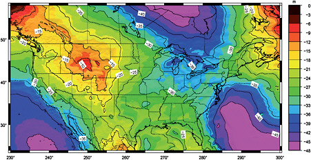
FIGURE 4.7 The geoid height over the continental United States based on GEOID09. Negative values indicate that the geoid is lower than the reference ellipsoid (positive values, above). For purposes of determining the direction of water flow, the absolute height of the geoid is not important but, rather, it is the slope in the geoid relative to the land surface that matters. GEOID09 is based on EGM2008 (Pavlis et al., 2008a), which in turn relied on GRACE for the long-wavelength component of the gravity field model. SOURCE: NGS (http://www.ngs.noaa.gov/GEOID/GEOID09/).
a gravity observatory near Boulder, Colorado equipping it with a cryogenic (superconducting) gravimeter and an absolute gravimeter. The absolute gravimeter was commercialized, and scientific organizations in nations around the world purchased the U.S.-manufactured instruments and began ambitious cooperative observing programs. The current programs using these absolute gravimeters are organized under the International Gravity Field Service, a new “umbrella” service of the International Association of Geodesy coordinating the collection, archiving, and distribution of gravity-related data, software, and information.
Recommendation: Because absolute and cryogenic gravity observations, when combined with GNSS/GPS observations, offer unique insight into glacial rebound and subsurface mass movement, the United States should reinvigorate its once world-class gravity program.
Tide Gauges
The global tide gauge network is important for geodesy in several respects. Historically, tide gauge data helped in defining geodetic reference heights (“datums”) at country scales. Recall that elevation or orthometric height is defined relative to mean sea level. In addition, tide gauge data provide information on ocean tides and long-term variations in sea level. Tide gauge data are especially critical for calibrating in-orbit altimetric satellites. For example, using a set of about 50 high-quality tide gauges distributed around the world Mitchum (1998) detected an artificial drift in the TOPEX/Poseidon altimeter caused by an algorithm error. Since then, drifts of instruments (in particular, radiometers used for measuring atmospheric water vapor) onboard altimeter satellites are routinely monitored by systematically comparing altimetry-derived and tide gauge-based sea level variations (see Mitchum, 2000; Nerem and Mitchum, 2001). Using GNSS/GPS-corrected tide gauges, Wöpplemann et al. (2009) estimated that regional sea level trends were different using the ITRF from the year 2000 versus the ITRF from the year 2005 due to the systematic differences between the two ITRF solutions.
The largest database of monthly and annual mean sea level records from tide gauges is the Permanent Service for Mean Sea Level (PSMSL) (Woodworth and Player, 2003). Although the PSMSL includes data from approximately 2,000 sites in about 200 nations, the records are inconsistent in terms of data length and quality. Only about 10-20 percent of this data set is useable for long-term sea level studies. For oceanographic, climate, and coastal sea level research, a core network of 290 high-quality PSMSL stations has been designed and is called the Global Sea Level Observing System (GLOSS), which is coordinated by the Intergovernmental Oceanographic Commission (Woodworth and Player, 2003). The distribution of the GLOSS network is presented in Figure 4.8.
One of the primary uncertainties in tide gauge calibration is the vertical motion of the ground at individual tide gauges. Mitchum (1998) proposed to design a dedicated network of globally-distributed tide gauges with GNSS/GPS correction for land movement that would be able to detect altimeter drift errors of one millimeter/year for a three-year period. Since then, tide gauges have proven to be extremely useful for calibrating satellite altimetry systems. Nevertheless, accurate knowledge of vertical land movements at tide gauge sites is still lacking. A significant part of the 0.4-0.6 millimeter/year uncertainty in the altimetry-derived rate of global mean sea level rise comes from reference frame errors or from the lack of any measurement of the vertical motions of the tide gauges used for calibration (Nerem and Mitchum, 2001; Beckley et al., 2007).
In 2001, the International GNSS Service established a pilot project called TIGA (GPS TIde GAuge bench mark monitoring) (Bevis et al., 2002) with an objective of establishing the required research infrastructure (observing stations, data centers, and dedicated analysis centers) for determining vertical motions at tide gauges to an accuracy of better than one millimeter/year within a
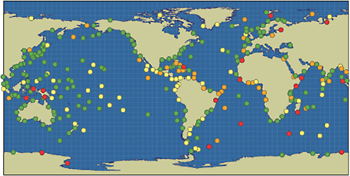
FIGURE 4.8 The GLOSS network of tide gauges. Green dots represent “operational” stations for which the latest data were collected in 2003 or later. Yellow dots represent “probably operational” stations for which the latest data were collected within the period 1993-2002. Orange dots represent “historical” stations for which the latest data were collected earlier than 1993. Red dots represent stations for which no PSMSL data exist. SOURCE: Courtesy of the Permanent Service for Mean Sea Level and the Global Sea Level Observing System (GLOSS).
decade. Determining local vertical rates at such a level of accuracy remains challenging, however, partly because of challenges involved in maintaining the stability of the reference frame and maintaining frequent leveling (at least annually) between the GNSS/GPS antenna and the tide gauge in places where these are not closely co-located. Regular leveling surveys are often neglected over time, particularly in places where the distance between the two instruments is large. Where this distance is more than one kilometer leveling ties error can be large and become a significant part of the error budget. Thus, except for sites with well-established local or regional stability, GNSS/GPS stations more than one kilometer from the tide gauge cannot really be considered as co-located. In many cases the GNSS/GPS station may need to be located on or very close to the tide gauge to represent its vertical motion accurately
Recommendation: The Committee recommends that the United States support the TIGA initiative and similar efforts to accurately determine the vertical motion of reference tide gauges.
EARTH OBSERVATION SATELLITES
Artificial satellites are an essential component of the precise geodetic infrastructure. These satellites provide the link between the global reference frame and the end user of geodetic products. Indeed, without the satellite component there would not be an ITRF. The artificial satellites can be broadly divided according to the measurements they provide (Table 4.1). GNSS/GPS satellites are used for precise point positioning anywhere on or near Earth’s surface (including low-Earth orbit). Satellite altimetry (radar or laser) provides elevation profiles of ocean, land, and ice surfaces at accuracies needed to monitor, for example, global mean sea level or polar ice sheet changes. Inter-
TABLE 4.1 Geodetic Satellites and Applications
|
Technology Orbit Height |
Type |
Agency |
Date |
Applications |
|
Global Navigation Satellite Systems (GNSS) |
||||
|
GPS 26,600 km |
Global Positioning System |
DoD |
1980-present |
Precise positioning, solid Earth, hydrology, glaciology, atmosphere, ionosphere, natural hazards |
|
GLONASS 19,100 km |
GLObal NAvigatsionnaya Sputnikovaya Sistema |
USSR/Russia |
1982-present |
|
|
Galileo 23,300 km |
Global Navigation Satellite System |
ESA |
testing |
|
|
Beidou-2 or COMPASS 36,000, 21,500 km |
Regional/Global Navigation Satellite System |
China |
2007-present |
|
|
Satellite Altimetry |
||||
|
SeaSAT 800 km |
Radar |
NASA |
1978 |
Oceanography, sea level rise hydrology, glaciology, marine gravity bathymetry |
|
GeoSAT 800 km |
Radar |
DoD |
1985-1989 |
|
|
TOPEX/Poseidon 1330 km |
Radar |
NASA/CNES |
1992-2006 |
|
|
Jason-1/2 1330 km |
Radar |
NASA/CNES |
2001-present |
|
|
ERS-1/2 780 km |
Radar |
ESA |
1992-present |
|
|
ENVISAT 780 km |
Radar |
ESA |
2002-present |
|
|
ICESAT 600 km |
Laser |
NASA |
2003-2010 |
Glaciology, hydrology oceanography |
|
CryoSAT-2 720 km |
SAR/Interferometric Radar |
ESA |
2010-present |
|
|
Interferometric Synthetic Aperture Radar (InSAR) |
||||
|
ERS-1 780 km |
C-band, VV polarization |
ESA |
1992-1996 |
Solid Earth, hydrology, glaciology, oceanography, geotechnical, natural hazards |
|
ERS-2 780 km |
C-band, VV polarization |
ESA |
1996-present |
|
|
JERS-1 570 km |
L-band, HH polarization |
JAXA |
1992-1998 |
|
|
Technology Orbit Height |
Type |
Agency |
Date |
Applications |
|
RADARSAT-1 800 km |
C-band, HH polarization |
CSA |
1995-present |
|
|
SRTM 233 km |
C-band, fixed baseline interferometer, HH,HV,VH,VV |
NASA |
2000 |
|
|
ENVISAT 780 km |
C-band, VV+VH, HH+HV |
ESA |
2002-present |
|
|
ALOS 690 km |
L-band, quad-polarization |
JAXA |
2006-present |
|
|
RADARSAT-2 800 km |
C-band, quad-polarization |
CSA |
2007-present |
|
|
TerraSAR-X 514 km |
X-band, quad-polarization |
DLR |
2007-present |
|
|
COSMO-SkyMed 619 km |
X-band, quad-polarization |
ASI |
2007-present |
|
|
Geodetic Missions (Reference Frame, Gravity or both) |
||||
|
Starlette/Stella 812 km |
Laser satellite |
CNES |
1975/1993-present |
|
|
LAGEOS-1/2 5620 km |
Laser geodynamics satellites |
NASA |
1976-present |
|
|
Etalon-1/2 19,100 km |
Laser satellites |
Russia |
1989-present |
|
|
CHAMP 350 km |
Challenging Minisatellite Payload |
DLR |
2000-present |
|
|
GRACE 460 km |
The Gravity Recovery and Climate Experiment |
NASA/DLR |
2002-present |
|
|
GOCE 250 km |
Gravity field and steady-state Ocean Circulation Explorer |
ESA |
Launched 2009 |
|
|
Agencies: CNES – National Space Study Center (France); CSA – Canadian Space Agency; DLR – German Aerospace Center; DoD – Department of Defense (USA); ESA – European Space Agency; JAXA - Japan Aerospace Exploration Agency; NASA – National Aeronautics and Space Administration (USA); ASI - Italian Space Agency Abbreviations: HH (Horizontal transmit, Horizontal receive); HV (Horizontal transmit, Vertical receive); VH (Vertical transmit, Horizontal receive); VV (Vertical transmit, Vertical receive). SOURCE: Modified from Wdowinski and Eriksson, 2009. |
||||
ferometric Synthetic Aperture Radar (InSAR) is a swath-mapping radar used to measure topography and topographic change over ocean, land, and ice surfaces. Finally, gravity missions measure the spatial and temporal variations in Earth’s gravity field associated with water redistribution between the atmosphere, oceans, groundwater, and ice sheets.
These satellites both rely on and help to define the ITRF. Their contribution to the reference frame depends mostly on the altitude of their orbit. Satellites in high-altitude orbits (higher than 5,000 kilometers) fly well above the outermost atmosphere of the Earth, and ground-based tracking of these high Earth-orbiting satellites is an essential component in defining and maintaining the accuracy of the ITRF. These satellites contribute to the definition of the location of Earth’s center of mass, Earth’s response to lunar and solar tidal forces, and the changes in Earth’s shape due to post-glacial rebound, large-scale changes in ocean circulation, and ice melting in mountain glaciers and polar ice sheets.
Geodetic satellites generally require medium or high-precision orbits though the exact level of accuracy needed depends on the application. Three main types of tracking systems are used. First, radar tracking of all orbiting material provides orbital accuracies at the 100-meter level, which is needed for space reconnaissance and collision avoidance. Second, much more precise tracking (1-10 centimeters) can be achieved by including a geodetic-quality GNSS/GPS or DORIS receiver onboard the satellite. These high-accuracy tracking systems are essential for most of the Earth science applications discussed in this report. Third, SLR offers a relatively inexpensive failsafe method of precise satellite tracking (to the centimeter level or better). Completely passive geodetic satellites such as LAGEOS, Starlette, Stella and Etalon, which will remain as stable orbiting reference points for hundreds or even thousands of years, are exclusively tracked by SLR. When multiple tracking systems are available they are often combined (with their data weighted according to performance) to provide the most accurate orbits. Alternatively, SLR tracking is sometimes withheld from the orbit solution to provide an independent assessment of the orbit accuracy. SLR data are unique in that they yield absolute range measurements between the ground and satellite independently of the orbit (some prior knowledge of the orbit is required only for “acquiring” the target satellite, that is, aiming the laser beam accurately). In contrast, for techniques like GNSS/GPS and DORIS estimation of all biases and corrections is not an independent procedure, but is instead an intrinsic part of the orbit solution. The use of SLR to verify the radial accuracy (height) of the orbit is especially critical for altimeter missions.
Though GNSS/GPS and DORIS are now routinely used for operational orbit determination on most geodetic satellites that require high precision orbits, SLR has proven to be vital as a backup tracking system. For example, the primary tracking aboard the European Space Agency’s Earth Remote Sensing satellite (ERS-1) failed immediately after launch, and the GPS receivers aboard the Geosat Follow-on Mission (GFO) failed in spite of four-unit redundancy. Fortunately, both satellites had an optical corner cube to enable SLR tracking to achieve sub-decimeter accuracy orbits. Without this SLR backup, both missions would have been nearly complete failures. Another example is RADARSAT-1, which was launched without any precise tracking capability just after the development of InSAR. InSAR has revolutionized our images of earthquakes, volcanoes, and ice streams but relies on an orbit accuracy of one meter or better. Although RADARSAT-1 was launched just three years after ERS-1 and had a superior radar, it was rarely used for the interferometric investigations because of its lack of precise orbital information. It is absolutely essential for any geodetic satellite mission that at least one of the precise tracking systems (GNSS/GPS, DORIS, or SLR) is functioning or the mission may fail to achieve its objectives. Onboard tracking receivers cannot be repaired after the satellite is injected into orbit so every geodetic satellite needs to be equipped with an optical corner cube for backup SLR tracking.
INTERNATIONAL GEODETIC SERVICES
For each one of the four primary geodetic techniques (VLBI, SLR, GNSS/GPS, and DORIS), an international service coordinated within the International Association of Geodesy (IAG) organizes and coordinates the data that are acquired, manages the analysis of that data, and generates products for users. These services develop the necessary standards and conventions and encourage international adherence to those conventions in the processing of the data provided by each technique. These services are critical components of the geodetic infrastructure.
As an example, the International VLBI Service (IVS) is essential to acquiring the basic data since VLBI measurements must be coordinated between the various stations to observe the same radio sources at the same time. The stations cannot work independently, and each observing run must be planned in detail. The IVS interacts with the users of VLBI products to integrate VLBI into the global Earth observing system, sets performance standards for the observing stations, establishes conventions for data formats and products, and issues recommendations for analysis software. Finally, the IVS sets the standards for analysis documentation and institutes appropriate product delivery methods in order to ensure product quality and timeliness. The IVS consists of about 30 Network Stations acquiring high-performance VLBI data; three Operation Centers coordinating the activities of a network of network stations; six Correlators processing the acquired data, providing feedback to the stations, and providing processed data to the analysts; six Data Centers distributing the products to users and providing storage and archiving functions; 21 Analysis Centers analyzing the data and producing the results and products; eight Technology Development Centers developing new VLBI technology; and one Coordinating Center coordinating daily and long-term activities. This adds up to more than 75 components representing more than 30 institutions in 16 countries.
The International GNSS Service (IGS) is a collaboration of approximately 200 organizations comprising diversely funded government agencies, universities, and other groups around the world that contribute data and analysis capability for GNSS/GPS. The products generated by the IGS analysis centers are freely available and include core products such as precise orbits and clock corrections for GNSS/GPS satellites (currently GPS and GLONASS), and tropospheric and ionospheric parameter estimates. The IGS orbit products are available on time scales ranging from near-real-time and predicted orbits (ultra-rapid product) to the most accurate orbits (final orbit product), which are available with 2-week latency. Comparisons among the IGS analysis centers show that the IGS ultra-rapid orbits have an internal consistency of better than five centimeters, while the IGS final orbits currently have an internal consistency at the one to two centimeter level. Comparisons with SLR tracking of the two GPS satellites that have reflector arrays indicate an absolute orbit accuracy better than five centimeters. The IGS products, particularly the precise orbits and GPS clock solutions, have become integral in a wide variety of civil and scientific activities. Even U.S. government agencies commonly rely upon the routine availability of the IGS products although some of these agencies such as the National Geospatial-Intelligence Agency have the capacity to generate such products independently. It is now common for geodetic missions to operate a GNSS/GPS receiver on board their satellites for precision orbit determination, relying upon either the IGS orbits and clock solutions or the ground data collected by the IGS network for computing their own solutions. The IGS analysis centers also now provide the dominant contribution to the determination of the Earth’s polar motion. Like the other services, the IGS sets antenna monumentation standards for the observing stations, establishes conventions for data formats and products, and issues recommendations for analysis models, constants, and procedures.
The International Laser Ranging Service (ILRS) provides satellite and lunar laser ranging data and their related products to support geodetic and geophysical research activities. Satellite tracking priorities are agreed upon by the ILRS to best reflect the tracking data needs of each mission and its overall contribution to the geodetic community with special tracking campaigns sometimes
organized for particular investigations of limited duration. The ILRS analysis centers receive and process tracking data from one or more data centers for the purpose of producing ILRS products without interruption at an interval and with a time lag specified by the Governing Board to meet ILRS requirements. The analysis centers are committed to producing Earth orientation parameters on a weekly or sub-weekly basis, as well as other products, such as station coordinates, on a regular basis. This analysis also provides a second level of quality assurance on the global data set by monitoring individual station range and time biases.
The International DORIS Service (IDS) serves a similar function for the community that relies upon the DORIS technique. IDS distributes the tracking data and derived products, establishes conventions for data and product formats, and issues recommendations for analysis models. It interacts with CNES, the agency controlling the DORIS system, regarding opportunities to deploy DORIS beacons in geodetically useful or geophysically interesting locations.
The International Gravity Field Service (IGFS) is a new “umbrella” IAG service coordinating the collection, archiving, and distribution of gravity-related data, software, and information. It does not distribute the gravity data directly, but rather functions as a unifying service for the various gravity-related IAG services. The data of the IGFS services include satellite-derived global models; terrestrial, airborne, satellite, and marine gravity observations; Earth tide data; GNSS/GPS leveling data; digital models of terrain and bathymetry; and gravity field information from satellite altimetry. The IGFS coordinates the Bureau Gravimetrique International in Toulouse, France; the International Geoid Service in Milano, Italy; the International Center for Earth Tides in Papeete, French Polynesia; the International Center for Global Earth Models in Potsdam, Germany; and the International Digital Elevation Model Service in Leicester, United Kingdom.
Finally, the International Earth Rotation and Reference System Service (IERS) provides the main geodetic references needed by the astronomical and geodetic communities, which are the celestial and terrestrial reference frames, and the Earth rotation and orientation parameters connecting these two frames. The IERS products are generated by combining the products from individual geodetic techniques enabling the IERS to take advantage of the strengths and mitigate the weaknesses of the individual contributions. So that these individual contributions are consistent and at the highest level of accuracy, the IERS coordinates the geodetic conventions, models, and constants used in the analysis of the geodetic data. The IERS Conventions are updated regularly as the models, constants, and procedures are improved.
In addition to these organizational services, data centers provide archiving of and electronic access to basic geodetic measurement data and products. The Crustal Dynamics Data Information System, funded by NASA’s Earth System Science Data and Services, provides access to the data from the VLBI, GPS, SLR, and DORIS techniques; the SLR data also is mirrored at the EUROLAS Data Center at the Deutsches Geodätisches Forschungsinstitut. The Physical Oceanography Distributed Active Archive Center, one of eight NASA Distributed Active Archive Centers, provides instrument data and derived products from a long list of oceanographic missions. It also is the U.S. distributor for the GRACE gravity mission data.3 Internationally, most geodetic services coordinate their operations through the Federation of Astronomy and Geophysics Data Analysis Services of the International Council for Science (ICSU). In 2008, ICSU recognized the need to update this half-century old organization as well as the World Data Centers and to develop a new World Data System (ICSU-WDS). The process of building this global scale collaboration is ongoing.4
A common feature, but also a source of concern, of the geodetic services is that they are built on the voluntary international collaboration of organizations (universities, space agencies, and geodetic national institutions) with distributed functions (Central Bureaus, Analysis Centers,
|
3 |
JPL Data Catalog: http://podaac.jpl.nasa.gov/DATA_CATALOG/index.html |
|
4 |
ICSU-WDS Website: http://icsu-wds.org |
Product Centers, Combination Centers, and other associated components). The current service components are primarily funded and maintained by their host countries on behalf of the scientific community. Research studies are undertaken by the participating institutions in order to produce the highest-quality products. Directing and Governing Boards of the services have the important role of reviewing the work of the different components of the service, coordinating their actions, and deciding policy. For the ILRS Central Bureau, the director, secretary, science coordinator, and two of the three analysis specialists are from the United States. For the IVS, the network and technology coordinators are from the United States, as are the Correlators and Operation Centers Representative. For the IGS, seven members of the Governing Board are from the United States, and NASA supports the IGS Central Bureau. This demonstrates that the various services are vulnerable to the vagaries of funding and support of the U.S. participants.
Recommendation: The United States should continue to participate in and support the activities of the international geodetic services (IGS, ILRS, IVS, IDS, IGFS and IERS) by providing long-term support for the operation of geodetic stations around the world and by supporting the participation of U.S. investigators in the activities of these services.
In summary, the geodetic infrastructure, which supports myriad national and international interests in the Earth sciences, consists of geodetic networks (ground-based instruments and their attached GNSS/GPS receivers, radio telescopes, laser tracking stations, DORIS beacons, tide gauges, and gravity meters), geodetic platforms (satellites, aircraft, and other vehicles), the geodetic data processing and service centers and, of course, the geodesists themselves. Each component is a critical link in the chain from the raw data to the refined measurements and products (such as the ITRF described in Chapter 5). A failure in any component is a failure in the technique, and all the techniques are required to support the important scientific studies addressing such issues as global climate change and natural hazard understanding, prediction, and mitigation.


