
Summary: A Shared National Resource
A middle-aged rocky planet, Earth offers a wondrous combination of interconnected systems. From its molten core below to the ionosphere above, planetary layers interact dynamically, moving constantly, affecting climate and environment, and impacting life of all forms on the planet. Quantifying these changes is essential to understanding the underlying processes well enough to identify their root causes and to anticipate and respond to future changes. Precise global geodesy is an essential tool to capture these changes.
Geodesy is the science of accurately measuring and understanding three fundamental properties of Earth: its geometric shape, orientation in space, and gravity field, and the changes of these properties with time.1 Over the past half century, the United States has been a world leader in the development of geodetic techniques and instrumentation. Today, these technologies enable scientists to determine the position of any point on the Earth with centimeter accuracy or better, to monitor variations in the time it takes the Earth to rotate around its spin axis with an accuracy of a few millionths of a second, to establish the orientation of Earth’s rotation axis in space with an accuracy of few billionths of one degree, and to measure changes in the Earth’s gravity that can perturb the position of an Earth-orbiting satellite by a few millionths of one meter. Geodetic observing systems provide a significant benefit to society in a wide array of military, research, civil, and commercial areas, including sea level change monitoring, autonomous navigation, tighter low flying routes for strategic aircraft, precision agriculture, civil surveying, earthquake monitoring, forest structural mapping and biomass estimation, and improved floodplain mapping (see Figure S.1 for a few examples of these applications).
In this report, the committee distinguishes between geodetic observing systems and geodetic infrastructure. Although these two overlap, they are distinguished by their primary purpose. When the report refers to geodetic observing systems (or in some cases geodetic observing networks), it is referring to systems that are designed to address specific goals (such as measuring sea level changes) and that may be used for a finite period of time. Geodetic infrastructure, on the other hand, supports
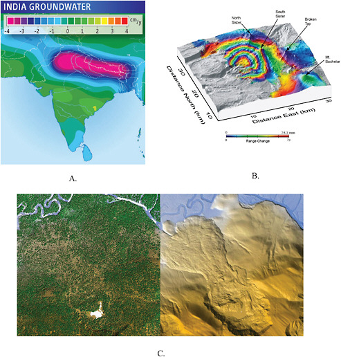
FIGURE S.1 The geodetic infrastructure supports many research and practical applications. For example, this infrastructure is critical to measuring: (A) Major groundwater depletion in India. (B) Uplift of the crust near the Three Sisters volcanoes, Oregon. (C) A landslide near Flathead Lake, Montana, revealed through the obscuring tree coverage using airborne LiDAR data collected by the NSF National Center for Airborne Laser Mapping (NCALM). These and other examples, as well as figure credits, are presented in Chapter 3.
all observing systems and applications over time; its main function is to provide the necessary information, such as the International Terrestrial Reference Frame (ITRF),2 that underpins many Earth observation missions and location-based applications. The strength of the infrastructure lies in its
longevity, continuity, stability, robustness, accuracy, speed of accessibility, and capability for supporting innovation through the development of new observing systems that exploit the accuracy of the infrastructure. Geodetic observing systems therefore rely on the existence of the geodetic infrastructure to achieve their goals.
Recognizing the growing reliance of a wide range of scientific and societal endeavors on infrastructure for precise geodesy, and recognizing geodetic infrastructure as a shared national resource, the National Aeronautics and Space Administration (NASA), the U.S. Naval Observatory (USNO), the National Geospatial-Intelligence Agency (NGA) of the Department of Defense (DoD), the National Science Foundation (NSF), the National Geodetic Survey (NGS) of the National Oceanic and Atmospheric Administration (NOAA), and the U.S. Geological Survey (USGS) requested the National Research Council (NRC) to establish a committee to provide an independent assessment of the benefits provided by geodetic observations and networks, as well as a plan for the future development and support of the infrastructure needed to meet the demand for increasingly greater precision (Box S.1). In response to this charge, the committee made a series of focused recommendations in the body of this report for upgrading and improving specific elements of the infrastructure, for enhancing the role of the United States in international geodetic services, for evaluating the requirements for a geodetic workforce for the coming decades, and for providing national coordination and advocacy for the various agencies and organizations that contribute to the geodetic infrastructure. This summary provides a set of overarching recommendations that address Tasks 2 through 5, which are based on the analysis of information provided throughout the report. These follow from the committee’s core recommendation:
Recommendation: The United States, to maintain leadership in industry and science, and as a matter of national security, should invest in maintaining and improving the geodetic infrastructure, through upgrades in network design and construction, modernization of current observing systems, deployment of improved multi-technique observing capabilities, and funding opportunities for research, analysis, and education in global geodesy.
|
BOX S.1 Committee Charge Improvements in positioning, navigation, and timing have always driven exploration and understanding of our world. Recognizing the national importance of maintaining and improving the global, high precision geodetic infrastructure that is fundamental to scientific discovery and leadership, and the applications to societal well-being and a vast array of commercial activity, the committee will:
|
GEODETIC INFRASTRUCTURE
The benefits of the geodetic infrastructure to society are profound and diverse, and this infrastructure has served the nation well by enabling the United States to establish a leadership position in
commercial, civil, and scientific applications of geodesy. Many stakeholders depend on the geodetic infrastructure and contribute to it (see Table 1.1); these departments and agencies support a range of activities serving economic, scientific, and national security interests.3
Despite the reliance of many stakeholders on high-precision geodetic infrastructure, there is no formal governance structure or lead agency explicitly responsible for this infrastructure. Its many components have been developed separately, often to serve specific purposes rather than to support global applications, such as maintaining the ITRF. Increasingly, however, geodesists have found that using these different components in combination can strengthen and improve the accuracy of any specific observing system. Thus, as new observing systems come online, they are designed to depend on the existence of the underlying shared infrastructure.
In the broadest sense, the geodetic infrastructure includes a wide suite of ground-, air-, and space-based geodetic observing systems and their support structures; systems and standards for geodetic data analysis and combination; computational facilities and procedural structures for analysis and combination of global data sets; and archival and distribution systems for geodetic data and data products. This report focuses on the components of the geodetic infrastructure that contribute globally, in particular the four geodetic hardware systems and associated services that form the backbone of the ITRF. These four systems are Very Long Baseline Interferometry (VLBI), Satellite Laser Ranging (SLR) and Lunar Laser Ranging (LLR), Global Navigational Satellite Systems (GNSS)/Global Positioning Systems (GPS), and Doppler Orbitography and Radio positioning Integrated by Satellite (DORIS). The United States developed and operates GPS, the most widely used global navigational system; France developed and operates DORIS; VLBI and SLR were developed and are operated in collaboration with a variety of international partners. Each system consists of a collection of sites equipped with hardware to determine and compile precise location information. Together these systems provide information about the Earth’s short-term (daily and shorter) and long-term (years and longer) motions, and importantly, information required to establish and maintain the ITRF.
The data acquired by these infrastructure systems travel a long path (Figure S.2). The data from each system (dark blue box in Figure S.2) are analyzed (red box) to provide intermediate data products, which are then combined to yield the information (green) that can then be easily incorporated into other observing systems by users (cyan). Thus, at the lowest levels, these systems must be coordinated to ensure that there is complete consistency and that errors are not introduced at any stage. In fact, the global geodetic community has worked for decades to provide common standards for analysis and data formats for the precise global geodetic infrastructure, of which the U.S. sponsored geodetic infrastructure is a leading component.
The past decades have seen tremendous growth in the utilization of observations and methods that are dependent on the geodetic infrastructure for scientific and practical applications, and today many billions of dollars are invested in U.S. satellites and ground-based networks that rely on the high-precision geodetic infrastructure. The geodetic infrastructure, however, is currently operating far below its optimal state, both in terms of number of sites and in modernization of instrumentation. This report provides recommendations for modernizing the observing systems of the existing infrastructure to make them more robust. The most effective use of resources would be to upgrade existing sites, thereby maximizing the value of past investments and extending the contributions of existing sites to the long-term geodetic infrastructure.
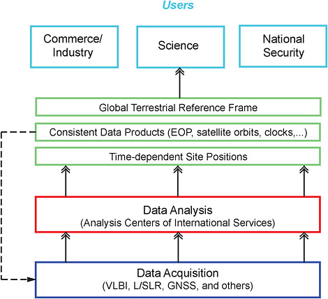
FIGURE S.2 The users of the geodetic infrastructure are organizationally removed from the systems that acquire the data. Raw data acquired by geodetic observing systems (described briefly in Chapter 1 and in some detail in Chapter 4) that form part of the geodetic infrastructure must first be analyzed in a consistent framework. This analysis is coordinated by international services and provides consistent precise data products, such as Earth-orientation parameters (rotational speed and direction of Earth’s spin axis) and information on GNSS satellite orbits and clocks. The data products include technique-specific time-dependent site positions that are then combined to determine the ITRF (see Chapter 5), which serves as a standard reference. Once all these data products have been produced, they enable or facilitate a range of commercial and scientific applications (see Chapters 2 and 3).
Recommendation: In the near term, the United States should construct and deploy the next generation of automated high-repetition rate SLR tracking systems at the four current U.S. tracking sites: Haleakala, Hawaii; Monument Peak, California; Fort Davis, Texas; and Greenbelt, Maryland. It also should install the next-generation VLBI systems at the four U.S. VLBI sites: Greenbelt, Maryland; Fairbanks, Alaska; Kokee Park, Hawaii; and Fort Davis, Texas. Maintaining the long history of data provided by these sites is essential for reference frame stability as we transition between ever-evolving geodetic techniques.
The results of realistic simulations presented to the committee demonstrated that an increased densification of the global geodetic network to approximately 24 multi-technique or ‘fundamental’ stations could yield substantial improvements to the determination of the ITRF required to support the most demanding Earth science applications.
Recommendation: In the long term, the United States should deploy additional stations to complement and increase the density of the international geodetic network, in a cooperative effort with its international partners, with a goal of reaching a global geodetic network of at least 24 fundamental stations.
The committee also recognizes the importance of accurate gravity field measurements in support of space-based positioning techniques. Further, the proposed implementation of a national geoid-based4 height system, consistent with global gravity models and accurate to 1-2 centimeters, requires strong support for gravity satellite missions and a revitalized U.S. terrestrial (ground and airborne) gravity program. Such a program also would support the multiple scientific and civil applications that call for monitoring changes in the gravity field over regional and global scales.
In addition, the committee identified many new applications that would benefit from a real-time GNSS/GPS data stream. These applications include autonomous navigation for land, sea, and air vehicles and robotic equipment; precision tracking of aircraft for laser and radar imaging; monitoring of space weather with potential to affect power grids, navigation, and communications; forecasting for extreme weather events; measurement of ground displacement in landslides; early warning systems for earthquakes and tsunamis; and monitoring of such critical structures as bridges, dams, railways, and pipelines.
Recommendation: The United States should establish and maintain a high-precision GNSS/GPS national network constructed to scientific specifications, capable of streaming high-rate data in real-time. All GNSS/GPS data from this network should be available in real-time without restrictions (and at no cost or a cost not exceeding the marginal cost of distribution), as well as in archived data files.
A GLOBAL COLLABORATION
With geodetic infrastructure deployed at sites around the Earth, modern geodesy is a global effort. This global infrastructure is organized by services of the International Association of Geodesy (IAG), including the International GNSS Service (IGS), the International VLBI Service (IVS), the International Laser Ranging Service (ILRS), International Gravity Field Service (IGFS), International Earth Rotation and Reference Systems Service (IERS), and the International DORIS Service (IDS). Each of these services archives data sets from a global network of stations, organizes and sets standards for data analysis, and distributes data sets and data analysis products without restrictions.
The United States plays a leading role in these services and benefits greatly from them. In effect, these services represent a force multiplier for the U.S. geodetic infrastructure. Playing a leading role enables the United States to exert a strong and lasting influence on standards and practices for the global geodetic network and data products.
Recommendation: The United States should continue to participate in and support the activities of the international geodetic services (IGS, ILRS, IVS, IDS, IGFS and IERS) by providing long-term support for the operation of geodetic stations around the world and by supporting the participation of U.S. investigators in the activities of these services.
Specifically, a long-term national commitment to the primary global geodetic product—the International Terrestrial Reference Frame—would ensure continuity and stability of the reference frame, and the many geodetic observing systems that depend on it.
Recommendation: The United States, through the relevant federal agencies, should make a long-term commitment to maintain the International Terrestrial Reference Frame (ITRF) to ensure its continuity and stability. This commitment would provide a foundation for Earth system science, studies of global change, and a variety of societal and commercial applications.
The committee also endorses the Global Geodetic Observing System (GGOS), a component of the Global Earth Observation System of Systems (GEOSS), being built under the aegis of the Group on Earth Observations (GEO), a voluntary partnership of governments and international organizations of which the United States is a leading member. GGOS links together existing and planned observing systems around the world and promotes common technical standards so that data from all these systems can be combined into coherent data sets. GGOS was conceived and introduced by the International Association of Geodesy as the new paradigm for sustained international cooperation toward integrating space-based geodetic techniques. The maintenance and development of the global precision geodetic infrastructure is recognized by GEO as a cross-cutting activity that affects many aspects of Earth science and the lives of most inhabitants of the planet.
A FOUNDATION FOR FUTURE GROWTH
The astonishing advances toward higher geodetic accuracy at increasing temporal resolution are made possible only by all components of the geodetic infrastructure working together as a coherent system. The components of the geodetic infrastructure, however, are dispersed among various departments, agencies, and organizations. Each of these bodies has independent missions and requirements, and there is no clear chain of responsibility and authority for maintaining, upgrading, and augmenting the geodetic infrastructure.
The nation’s precise geodetic infrastructure has not been considered holistically before now. Nevertheless, the geodetic infrastructure is a shared asset that is required for the nation to maintain its global leadership in economic and scientific spheres and to sustain national security into the future. Cooperation between and within national agencies and international services is essential to ensure the long-term viability of the geodetic infrastructure. Fortunately, the discipline of geodesy offers a conceptual framework that has proven very successful on a global scale and that could be adapted to satisfy national needs.
Recommendation: The United States should establish a federal geodetic service to coordinate and facilitate the modernization and long-term operation of the national and global precise geodetic infrastructure to ensure convenient, rapid, and reliable access to
consistent and accurate geodetic data and products by government, academic, commercial, and public users.
Establishing a federal geodetic service may not require the creation of a new independent agency, and it does not supersede the missions and strategic plans of the many agencies that currently support and rely on the geodetic infrastructure. Indeed, the federal geodetic service would support the missions of those agencies by drawing attention to the vital role of these otherwise separate and uncoordinated efforts. The unique mission of the federal geodetic service would be to ensure that the geodetic infrastructure meets the evolving future economic, scientific, and national security needs of the nation. It would achieve this mission by:
-
maintaining, modernizing, and augmenting the geodetic infrastructure;
-
coordinating the scientific and technical requirements and applications across stakeholders, including federal and state agencies, the scientific community, and commercial and public users;
-
selecting a primary provider and clearinghouse agent for data products, such as raw instrumental data, tracking data, and the necessary metadata;
-
coordinating the production and dissemination of data products, especially when the utilization of identical products by most or all end-users would be demonstrably beneficial or, in some instances, critical (for example, orbit information for precise navigation);
-
supporting emerging geodetic technologies, such as geodetic imaging, and developing the associated tools and data sets to support these technologies;
-
fostering fundamental research and education focused on technological and theoretical developments, ongoing deployments, and novel uses of precise global geodetic infrastructure; and
-
functioning as the lead U.S. partner in the deployment of global infrastructure and international services.
The committee considered the role and function of the National Executive Committee on Space-Based Positioning, Navigation, and Timing (PNT). Although PNT delivers basic and essential administrative coordination at the national policy and agency level, it is not currently charged with coordinating activities at the data product level, nor is it charged with orchestrating the community to insure an orderly and effective development and promotion of data and data product standards. Thus, a federal geodetic service is needed to provide a centralized access point for accurate, consistent geodetic information for government, academic, and commercial users through state-of-the-art technology, such as internet portals.
This report discusses several possible approaches for implementing the federal geodetic service. These include: (1) assign to a lead agency the responsibility and the necessary resources to act as the federal geodetic service; (2) create an embedded organization that consolidates the federal geodetic service activities into a new organization within one of the existing agencies; or (3) create a multi-agency federal service based on the model of the international geodetic services. Because it would take advantage of the existing talent and expertise in federal and state government agencies, research organizations, academia, and industry, the federal geodetic service would require a small staff.
For this service to succeed and be sustainable, innovative, and flexible, it is imperative that its staff be steeped in state-of-the-art scientific research in precise global geodesy. For this purpose, all agencies that support scientific research in this field (for example, DoD, NASA, NOAA, NSF, and USGS) ideally would provide input to the strategic plan of the service. Periodic independent advice from other stakeholders in the public and private spheres and those operating at the local and global levels would ensure that the service continues to provide reliable access to accurate geodetic information.
Finally, the committee found that one of the “weakest links” in the implementation of a precision geodetic infrastructure was a lack of a trained workforce to develop and maintain the infrastructure in the coming decades. Skilled workers are needed to obtain the highest level of accuracy from the infrastructure, assess the capabilities of the infrastructure as it continues to evolve, and capitalize on advances in technology to improve the accuracy or decrease the cost of the infrastructure. Representatives from every federal agency interviewed by the committee raised concerns about a perceived growing deficit of well-trained space geodesists and engineers with this necessary knowledge. As a science, geodesy has long been a niche discipline, populated by a small group of experts. Agencies are finding it difficult to replace these highly skilled geodesists as they retire, and instead are forced to hire young professionals from other disciplines whom they must train on the job. Although the committee did not collect or analyze quantitative demographic data about the geodesy workforce, anecdotal evidence presented by the agencies brought this issue to the fore.
Recommendation: A quantitative assessment of the workforce required to support precise geodesy in the United States and the research and education programs in place at U.S. universities should be undertaken as part of a follow-up study focused on the long-term prospects of geodesy and its applications.


