
THE NASA HELIOPHYSICS CORE PROGRAM
The systems approach for the study of the coupled Sun-heliosphere-Earth system that is advocated in this report requires flight opportunities that can provide observations of phenomena throughout the domain as well as adequate support of research and analysis activities to ensure that the full potential of the data is realized. With current projections showing at best level funding for solar and space physics over the coming decade, the survey committee was challenged to prescribe a program that would effectively “do more with less.” Among the key considerations in this effort are the appropriate mix and repeat-cycle (cadence) of small-, medium-, and large-class missions, and matching these efforts with a robust program of research and analysis and theory and modeling activities that will exploit, complement, add value, and, in effect, extend experimental observations. Further, in order to take advantage of future opportunities, there is an evident need to develop a well-trained workforce
The survey committee’s recommended core program for heliophysics includes the following elements, in descending order of priority:
1. Completion of the implementation of the NASA missions that are currently selected, with commitment to maintaining agreed-to costs and schedule commitments. These missions include RBSP (renamed the Van Allen Probes), MMS, Solar Probe Plus, and Solar Orbiter, along with IRIS and other already-selected Explorers.
2. Implementation of the DRIVE initiative as an augmentation to the existing enabling research program. The DRIVE components provide for operation and exploitation of the Heliophysics Systems Observatory for effective research programs. The community must be equipped to take advantage of new innovative platforms.
3. Execution of a robust Explorer program with an adequate launch rate, including Missions of Opportunity. The cadence should be accelerated to accomplish the important science goals that do not require larger missions and to provide access to space for all parts of the discipline.
4. Launch of strategic missions in the reinvigorated Solar-Terrestrial Probes (STP) line and in the Living With a Star (LWS) line to accomplish the survey committee’s highest-priority science objectives. This element includes first the notional IMAP investigation and then DYNAMIC and MEDICI in the STP program and GDC as the next larger-class LWS mission.
Figure 6.1 shows a proposed implementation of the core program, in which each of the assets required to achieve the goals of the survey committee’s recommended solar and space physics program have their
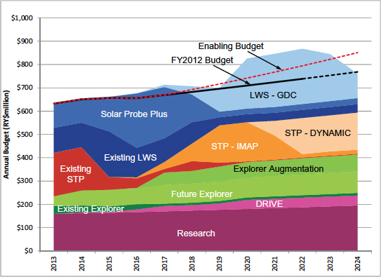
FIGURE 6.1 Heliophysics budget and program plan by year and category from 2013 to 2024. The solid black line indicates the funding level from 2013 to 2022 provided to the survey committee by NASA as the baseline for budget planning, and the black dashed line extrapolates the budget forward to 2024. After 2017 the amount increases with a nominal 2 percent inflationary factor. Through 2016 the program content is tightly constrained by budgetary limits and fully committed for executing existing program elements. The red dashed “Enabling Budget” line includes a modest increase from the baseline budget starting in 2017, allowing implementation of the survey-recommended program at a more efficient cadence that better meets scientific and societal needs and improves optimization of the mix of small and large missions. From 2017 to 2024 the Enabling Budget grows at 1.5 percent above inflation. (Note that the 2024 Enabling Budget is equivalent to growth at a rate just 0.50 percent above inflation from 2009.) Geospace Dynamics Constellation, the next large mission of the LWS program after Solar Probe Plus, rises above the baseline curve in order to achieve a more efficient spending profile, as well as to achieve deployment in time for the next solar maximum in 2024. NOTE: LWS refers to missions in the Living With a Star line, and STP refers to missions in the Solar-Terrestrial Probes line.
proper cadence, within a budget profile that should be attainable. The recommended program addresses in a cost-effective manner many of the most important and interesting science objectives, but the anticipated budget significantly constrains what can be accomplished. Built on top of the existing research foundation, the core program recommended here ensures that a proper distribution of resources is achieved. In particular, it restores a balance between small, medium, and large missions.
Figure 6.2 illustrates how, in the past decade, the number of large missions has increased at the expense of medium and small missions. With implementation of the committee’s recommended program, the bal-
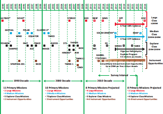
FIGURE 6.2 NASA mission sequence since 1990 by launch year and mission class. The strength of the heliophysics program over the past two decades has been the regular cadence of missions in a variety of sizes. It can be seen that the 1990 and 2000 decades each had 13 missions, with the Medium- and Explorer-class categories having 9 missions in each decade. A trend toward a loss of balance can be seen in the 2010 decade, in which the mission complement tipped toward fewer missions with a bias toward the Large category.
A key objective for the next survey interval is to restore the number of Medium- and Explorer-class missions such that, in combination with competitively selected instrument opportunities on hosted payloads (Missions of Opportunity), a higher cadence can be achieved that is capable of maintaining the vitality of the science disciplines. As discussed in the text and described in Figure 6.1, funding constraints affect the restoration and rebalance of the programs such that realization of the survey committee’s recommended strategy cannot begin until after 2017.
Missions denoted by an asterisk (*) demonstrate the importance of international collaborations in which the heliophysics community has a long, active, and very fruitful mission history. Open boxes indicate missions that are in development or are planned but have not yet flown.
ance between mission size and enabling research is restored. As shown in Figure 6.3, at the beginning of the 2013-2024 decade large missions from both the LWS and the STP lines dominate the budget. By the end of the decade, a balance between large, mid-size, Explorer, and enabling assets (baseline research plus DRIVE) has been achieved. The phasing that leads to this rebalance is implemented based on the priorities accorded to the elements of the core program. During the early part of the decade, when there is very little
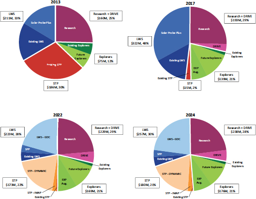
FIGURE 6.3 Effects of strategic rebalancing. These pie charts illustrate the evolution of program balance among four core program elements as the survey-recommended plan is implemented over the survey interval, 2013-2022, plus 2 years. The charts reflect that much of the NASA heliophysics budget from 2013 to 2017 is already locked in. The year 2017 is effectively the start for an enabling trajectory. An important result apparent in 2017 is the effect of implementing the DRIVE initiative and the restructured Explorer program. It can be seen that the sum of Research + DRIVE and Explorers (R + D + E) increases from approximately 37 percent to the intended value of 50 percent of the total program budget.
The year 2022 represents the endpoint of the survey interval and occurrence of the overall rebalancing of the program with the maintenance of the 50 percent R+D+E funding but also a sustainable division between the STP and LWS programs with the remaining 50 percent of the budget. The year 2024 represents the planned endpoint of the rebalancing initiative as well as the legacy profile for the next survey. An important legacy result is how the program stably maintains the balance moving forward from 2022. Note that the 2022 and 2024 budgets are represented by the enabling-trajectory budget and do not include the Geospace Dynamics Constellation bump, which is considered a plus-up from the base program.
flexibility in the NASA heliophysics program, the focus is on completing the implementation of existing missions, as well as on maintaining the baseline level of enabling research programs and Explorers. The first new recommendations of this survey to be acted on pertain to the DRIVE initiative. Early implementation of DRIVE ensures the fastest possible return on new investments for the decade (Figure 6.4).
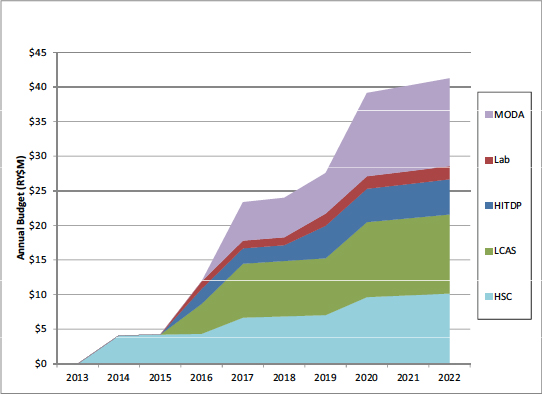
FIGURE 6.4 NASA DRIVE implementation. For the cost of a small mission, the DRIVE initiative includes recommended augmentations to NASA mission-enabling programs that have been carefully chosen to maximize the effectiveness of the program overall. Six of the DRIVE sub-recommendations made in Chapter 4 have a cost impact for NASA. Of these, a NASA mission guest investigator program would require a cost allocation within the Solar-Terrestrial Probes and Living With a Star missions of ~2 percent of total mission cost for a directed guest investigator program. Shown above are expected costs for the other five: a NASA tiny-satellites augmentation to the Low-Cost Access to Space program (LCAS), Mission Operations and Data Analysis augmentation (MODA), heliophysics science centers (HSCs), a heliophysics instrument and technology development program (HITDP), and a multiagency laboratory experiments program (Lab). They have been phased with a slow start because of budget constraints, and in sequence that allows for time to develop and ramp up new programs. Note that the MO&DA augmentation begins in 2016, at a time when the Solar Dynamics Observatory will have moved out of prime mission, adding greatly to data covered by the general guest investigator program. Implementation of the NASA portion of DRIVE ramps up by 2022 to an augmentation to existing program lines that is equivalent to approximately $33 million in current (2013) dollars. Note that in developing this figure, the survey committee assumed a 2.7 percent rate of inflation, which is what NASA currently assumes as the inflation factor to be used for its new starts.
The next priority element is the Explorer augmentation, and this is also to be acted on as early in the decade as possible. Explorer missions are cost-effective means of strategically pursuing new and exciting science. The recommended augmentation of the Explorer line allows for a restored MIDEX line to be deployed alternately with SMEX missions at a 2- to 3-year cadence and for regular selection of Missions of Opportunity.
The committee’s highest-ranked STP and LWS missions, IMAP and GDC, are implemented next, exploring the outer heliosphere and near-Earth space, respectively. The minimum recommended cadence for the STP missions is 4 years, and so IMAP, as a moderate-size mission, could launch in 2021 and be followed by DYNAMIC and MEDICI, the next-highest-ranked STP science targets (Figure 6.5). The recommended cadence for LWS is 6 years (Figure 6.6), and so only GDC could begin in this decade. Moreover, launching GDC even as early as 2024, as shown in Figure 6.1, would require an increase in the heliophysics budget,
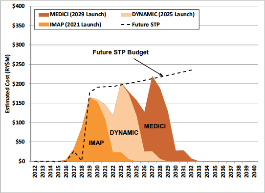
FIGURE 6.5 Recommended Solar-Terrestrial Probes (STP) program budget with associated mission cadence. The dashed line represents the recommended funding level for the STP program including a 2 percent inflation slope. Funding at the full level occurs in approximately 2019, with a 4-year mission cadence beginning with IMAP and then continuing with DYNAMIC and MEDICI. The dips in funding between missions are intentional, with the objective of allowing for both technology development and mission extensions.
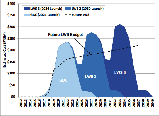
FIGURE 6.6 Recommended Living With a Star (LWS) program budget with associated mission cadence. The dashed line represents the recommended base funding level for the LWS program, including a 2 percent inflation slope. Funding at the full level occurs near the end of the decade, with a 6-year mission cadence beginning with GDC. The bumps above the future LWS budget line in mission funding are intentional in order to achieve the most cost-effective implementation at the preferred cadence. The actual bump will be based on mission cost and the associated development plan.
beyond a simple extension of the current budget. The increase would permit the timely execution of a major mission in coordination with related STP missions. However, if the required increase is not possible, it is appropriate to delay both the start and the launch date of GDC.
DECISION RULES AND AUGMENTATION PRIORITIES
The recommended program for NASA addresses important and highly compelling science objectives in a cost-effective manner. However, the survey committee recognizes that an already significantly constrained program could face further budgetary challenges. Decision rules are required to preserve an orderly and effective program in the event that less funding than anticipated is available, or some other disruptive
event occurs. The decision rules need to ensure that, under any funding profile, balanced progress can be made across the subdisciplines of solar and space physics and that the only adjustment that is possible, i.e., the cadence of NASA assets, is properly applied. To further guide the allocation of resources, the committee recommends the following decision rules.
Recommended Decision Rules for Maintaining Balance Under More Constrained Budgets
The decision rules should be applied in the order shown to minimize disruption of the higher-priority program elements.
Decision Rule 1. Missions in the STP and LWS lines should be reduced in scope or delayed to accomplish higher priorities (see below for explicit triggers for review of the Solar Probe Plus mission1).
Decision Rule 2. If further reductions are needed, the recommended increase in the cadence of Explorer missions should be reduced, with the current cadence maintained as the minimum.
Decision Rule 3. If further reductions are still needed, the DRIVE augmentation profile should be delayed, with the current level of support for elements in the NASA research line maintained as the minimum.
Rule 1 calls for the reduction in scope or delay of missions in the LWS or STP lines as the first line of defense against budget stress. However, the committee is aware that in the early years of the decade there is very little flexibility in the NASA heliophysics program. Only Solar Probe Plus (SPP) is not already in design and development, Phase C/D. SPP science remains important and timely (Box 6.1), but the mission is costly and technically challenging. Significant cost growth beyond the current cap threatens to disrupt the balance of the total program and should not be accepted without careful consideration. While a low-cost delay imposed early in the decade may have minimal impact, the committee otherwise recommends the following specific triggers for NASA to initiate a review of the SPP mission in order to maintain program balance during the first 5 years:
Trigger 1. A decrease in the heliophysics budget expected to cause an interruption in the current cadence of Heliophysics Explorers lasting more than 1 year, or that would impact the remainder of the core research program.
Trigger 2. A decrease in the heliophysics budget that prevents the Heliophysics Division from launching SPP and at least one new STP mission before 2022.
Trigger 3. An increase in the total SPP life-cycle cost above NASA’s projected $1.23 billion level,2 irrespective of where the cost growth occurs.
________________________
1 In accordance with its charge, the survey committee did not reprioritize any NASA mission that was in formulation or advanced development. In June 2011, the survey committee’s charge was modified by NASA to include a request for it to present “decision rules” to guide the future development of the Solar Probe Plus mission.
2 The committee understood the life-cycle costs of SPP to be approximately $1.23 billion as of September 2011, which is consistent with the President’s FY 2012 budget request announced in February 2011. NASA informed the survey committee that funding already appropriated for the advanced technologies required for SPP have retired substantial technical risk. Note: Life-cycle costs do not include potential mission extensions.
BOX 6.1 SOLAR PROBE PLUS—A MISSION TO THE CORE OF THE HELIOSPHERE
Solar Probe Plus (SPP) will travel closer to the Sun than any other spacecraft and explore the innermost region of our solar system—the corona. The 2003 decadal survey1 recommended a solar probe intended to “determine the mechanisms by which the solar corona is heated and the solar wind is accelerated and to understand how the solar wind evolves in the innermost heliosphere.” The present survey found that the scientific rationale for a solar probe remains compelling and concluded that SPP meets that challenge. SPP will study the streams of charged particles the Sun hurls into space from a vantage point where the processes that heat the corona and generate the solar wind actually occur. SPP will repeatedly sample the near-Sun environment and, using in situ measurements, reveal the mechanisms that produce the fast and slow solar winds, coronal heating, and the transport of energetic particles.
The region inward of 0.3 AU is one of the last unexplored frontiers in our solar system. Discovering how the solar wind originates and evolves in the inner heliosphere requires in situ sampling of the plasma, energetic particles, magnetic field, and waves as close to the solar surface as possible. SPP measurements will determine how energy flows upward in the solar atmosphere, heating the corona and accelerating the solar wind. SPP will also reveal how the solar wind evolves with distance in the inner heliosphere. During the past decade remote observations have revealed much about particle acceleration, heating, plasma turbulence, waves, and the flows of mass and energy in the corona. In the survey committee’s view, these observations only increase the need for measurements from this critical region.
The current solar probe differs in several respects from the mission envisioned in the 2003 survey. The closest approach for SPP is 9.5 solar radii (RS) instead of 4 RS (Figure 6.1.1). The loss in proximity is significant but is more than compensated for by the opportunity to spend far more time close to the Sun and gather observations spanning half a solar cycle. This latter feature in particular makes the timing of the mission with respect to the solar activity cycle a less significant issue. SPP orbits in the ecliptic plane instead of a polar plane and thus leaves the polar regions unexplored. Nevertheless, fast solar wind streams typical of polar coronal holes will still be adequately sampled, albeit at larger radial distances from the Sun. Only one remote sensing instrument remains on SPP, but the most significant impairment comes from the lack of in situ solar wind composition measurements; the survey committee urges NASA to consider restoring this capability. However, in most other aspects SPP offers the prospect of a substantially enhanced science return compared to the earlier solar probe concept.
The four science investigations provide a combination of in situ and remote sensing capability. Three in situ instruments will make comprehensive measurements of the solar wind ion and electron thermal plasma, of suprathermal and energetic particles, and of magnetic and electric fields from DC to high frequencies. A side-looking imager will provide both global context and quasi-in situ measurements of density and dust in the corona from 2.2 to 20 RS.
__________
1 National Research Council, The Sun to the Earth—and Beyond: A Decadal Research Strategy in Solar and Space Physics, The National Academies Press, Washington, D.C., 2003; and National Research Council, The Sun to the Earth—and Beyond: Panel Reports, The National Academies Press, Washington, D.C., 2003.
The committee emphasizes that what is called for is a review by NASA, in which the expected outcome will be actions by NASA with regard to SPP that preserve a program of balanced progress in heliophysics throughout the decade.
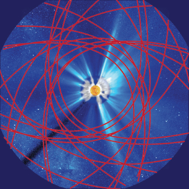
FIGURE 6.1.1 A simulated view of the Sun and inner heliosphere seen from above the pole illustrates the revamped trajectory of Solar Probe Plus during its 19 near-Sun passes inside 30 RS. The spacecraft will spend nearly 1,000 hours within 20 RS of the Sun and 30 hours within 10 RS. The 3-month near-ecliptic orbit allows repeated measurements of the slow wind from the streamer belt as well as of the fast wind from equatorial coronal holes. Terrestrial observatories, from both ground and space, will provide global context measurements. SOURCE: NASA, Solar Probe Plus: Report of the Science and Technology Definition Team, NASA/TM-2008-214161, NASA Goddard Space Flight Center, Greenbelt, Md., July 2008.
The survey committee notes that the resources assumed in crafting this decadal survey’s recommended programs are barely adequate to make the required progress; with reduced resources, progress will be inadequate. It is also evident that with increased resources, the cadence of the assets by which the nation pursues its program could be increased with a concomitant increase in the pace of scientific discovery and societal value.
Recommended Augmentation Priorities for Maintaining Balance Under More Favorable Budgets
The survey committee recommends the following augmentation priorities to aid in implementing a program under a more favorable budgetary environment:
Augmentation Priority 1. If even modest additional financial resources can be made available early in the decade, the implementation of the DRIVE initiative should be accelerated.
Augmentation Priority 2. Given sufficient funds throughout the decade, the Explorer line should be further augmented so as to increase the cadence and amount of funding available for missions including Missions of Opportunity.
Augmentation Priority 3. Given further budget augmentation, the cadence of STP missions should increase to allow the recommended third-priority mid-size science target (MEDICI) to be initiated in this decade.
Augmentation Priority 4. The major-mission-line recommendation (GDC) should be implemented in the most cost-effective manner, if possible with a funding bump as shown in Figure 6.1.
Collaborations between NASA and foreign space agencies have historically achieved major science at a relatively low cost to the United States. Missions labeled with an asterisk in Figure 6.2 are examples of such international collaborations. These include SOHO, Ulysses, Yohkoh, CLUSTER, Hinode, and Solar Orbiter. Collaborations with the Japanese space agency have been particularly fruitful, with investments of Explorer-size funds having resulted in full U.S. participation in major missions (Yohkoh, Hinode). Such missions leverage U.S. investments while simultaneously sustaining a U.S. leadership role in science.3
Opportunities continue to arise for NASA to collaborate with other nations, and in so doing to obtain a high science return at a relatively low cost. The Solar-C mission, a follow-on to Yohkoh and Hinode that will study the magnetic coupling of the lower solar atmosphere and the corona, has been confirmed by Japan and would greatly benefit from contributions of instrumentation from the United States. A mission concept has also been developed in Japan, Canada, and Europe that involves a fleet of spacecraft performing simultaneous in situ measurements of fields and plasmas at key locations in the magnetosphere. Finally, NASA support for the U.S.-Taiwanese FORMOSAT-3/COSMIC microsatellite science mission for weather, climate, space weather, and geodetic research illustrates the range of possible collaborative opportunities that might arise. The augmented Explorer line is the recommended source of funding for participation in most such international collaborations.
____________
3 At the same time, collaborations with international partners add complexity and risk that must be actively managed. See, for example, National Research Council, U.S.-European Collaboration in Space Science, National Academy Press, Washington, D.C., 1998.


